

MT HOOD WEATHER FORECAST
Hey skiers and snowboarders! Winter is back on Mt. Hood – the higher resorts picked up about 4” of new snow last night, and there are a few more inches of snow in the forecast today. Intermittent snow showers could add an inch or two mid-week, and after that, we fall into a period of true spring skiing: sunshine, warm temps, corn snow. Wonderful! Today’s the last forecast until I return from my month-long retreat. I should have a forecast up for you May 2nd. If not, definitely May 3rd!
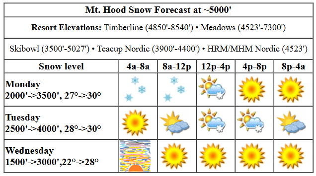
today’s mt hood weather forecast
Let’s look at today. It’s a snowy start up there on the volcano. The snow level is around 2000′ this morning. It’ll rise to 3500′ this afternoon and then the freezing level falls to 2500′ under clear sky tonight. Temps at 5000′ today range from 27F this morning to 30F this afternoon. About 0.3” water equivalent (WE) is forecast. That gives us another 3” of decent quality snow. Wind will be SW 15-25 this morning, SW 10-20 this afternoon, and light NW overnight.
tuesday mt hood weather forecast
Tuesday starts clear. Instability in the afternoon could trigger some snow flurries or even a thunderstorm with up to an inch of new snow. The snow level will be 2500′ in the morning, 4000′ in the afternoon, and the free air freezing level will fall to 1500′ under clear sky overnight. Temps start around 28F, rise to 30F, and fall to the low 20s overnight. Wind: light NW in the morning builds to NW 20-25 in the afternoon and turns to W 30 overnight. We can’t rule out a little orographic snowfall overnight with those winds, but models suggest there won’t be enough moisture at 5000′ for clouds and snowfall.
wednesday mt hood weather forecast
Wednesday starts partly high overcast and quickly turns clear. The free air freezing level will be 1500′ early, 3000′ in the afternoon, and 2500′ overnight. Temps: low 20s early, 28F in the afternoon, and mid 20s overnight. Wind: W 30 in the morning, W 10-15 in the afternoon, and light/variable overnight.
extended mt hood weather forecast
Sunny, dry weather is forecast on Thursday and Friday with a slow warming trend: temps max in the mid 30s on Thursday and near 40F on Friday. The weekend looks warm and sunny with the free air freezing level at 10,000′ or higher. .All righty – that’s all I’ve got for you until early May. Have a wonderful month on the snow. Get some for me!
Was that helpful? I knew it was! Guess what? All of this crucial work – from your personal wind and snow reports to the invaluable TATAS updates – is made possible by my relentless efforts. Maintaining this labor of love isn’t easy. Each daily forecast takes hours. Website hosting, weather model access, and back-end admin work takes time and money. That’s where you come in.
YOUR CONTRIBUTION MAKES A DIFFERENCE
- SUPPORT ACCURATE, HYPER-LOCAL WEATHER FORECASTING
- ENABLE ACCESS FOR ALL, EVEN THOSE WITH LESS MEANS
- SUPPORT A COOL HUMAN WHO WORKS HARD SO YOU CAN PLAY
Take a moment to click one of the buttons below. Donate $19.99 or more (how much does this forecast enhance your life?) and get the email in your inbox. Whether it’s a renewing subscription (auto-renew) or a one-time donation, every contribution makes a real difference. Help me keep this labor of love alive, so we can all continue playing, commuting, and living in the Gorge with peace of mind and the best weather forecasts possible. Thank you!


Hood River, Oregon 97031


GORGE WIND FORECAST

Hi friends! Westerlies make an appearance the next three afternoons, and if the timing on Tuesday is right, it could be a decent day. Note that river flow is way up, which should have you carefully considering the best spots to play. Rufus is out for SUP foiling over 200kcfs, and it’s out for windsurfing/kiting/winging around 300-325kcfs.
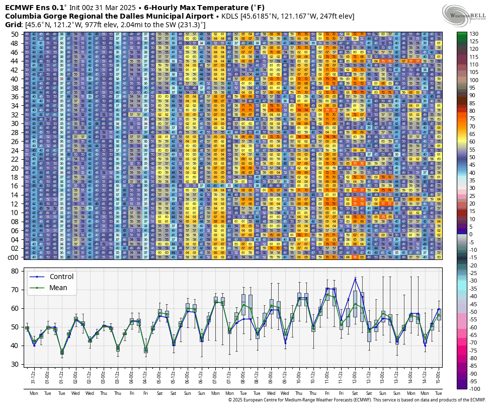
Monday kicks off with very light onshore gradients and a low far offshore making headway towards Oregon. As it approaches, it’ll nudge westerlies upward. By early afternoon, we’ll have 10-13 from Stevenson to The Dalles. After 2pm, we should have gusty 13-16 from Stevenson to Hood River, gusty 16-19 from Mosier to Doug’s,, and gusty 19-23 from Avery to Boardman. Rain will be part of the picture this morning, and instability will be present this afternoon. Expect low-quality wind and intermittent showers all the way to Arlington all the way into the evening. River flow over the last 24 hours was 223-254kcfs, river temp is 47.3F, and high temp forecast is 53F.
Tuesday starts calm. As the previously mentioned low moves inland and high pressure builds offshore in the afternoon, westerlies ramp up. As usual, timing is everything. As of this morning, models suggest 20-23 all the way from Stevenson to Arlington in the afternoon. This is a good setup for Swell to Doug’s and there’s a possibility the wind could over-perform if high pressure builds a bit early. High temp: 54F with lingering atmospheric instability and scattered showers.
Wednesday starts with 7-10 from Stevenson to Mosier and 17-20 from Lyle to Boardman. Models suggest the wind will focus on the sunny desert with 22-25 from Avery to Arlington. We can’t rule out swell: there’s a shot at 14-17 from Stevenson to Hood River and 17-20 from Mosier to Doug’s. High temp: 53F with clouds decreasing throughout the day. All right folks, that’s it. I’ll see you when I return from my retreat at the end of the month. Next forecast will probably be May 2. Have an awesome month!
BARE BONES HOOD RIVER WEATHER FORECAST
Clouds and rain this morning. Showery and partly cloudy this afternoon. Temps start in the low 40s and rise to the low 50s. Calm wind early. Moderate westerlies later. 99% chance of rainbows. Tuesday will be partly cloudy all day with instability-driven showers in the afternoon. Temps start in the mid 30s and rise to the mid 50s. Calm wind early. Moderate westerlies later. No rainbows. Wednesday will be cloudy then mostly clear. Temps start in the upper 30s and rise to the low 50s. Light westerlies in the morning. Moderate later. No rainbows.
TEMIRA’S AWESOME TRAVEL ADVISORY SERVICE
HYPERLOCAL WEATHER FORECAST FOR THE COLUMBIA GORGE
THE DALLES, HOOD RIVER, WHITE SALMON, TROUT LAKE, STEVENSON, CASCADE LOCKS, PARKDALE, ODELL, HUSUM, BZ, MILL A, WILLARD, GOLDENDALE, RUFUS, ARLINGTON, boardman
Good morning, neighbors! March is ending on a cloudy, drizzly note, but by the time we get to April, we’ll have more sun. Speaking of April, I’ll be on a silent retreat for the whole month, so this is the last forecast until May 2nd or 3rd. Lemme tell ya – I’m gonna be so excited to look at weather models and write a forecast when I get back!!!
Let’s look at Monday:
glenwood today!
No, wait, let’s look at Glenwood! 35 degrees and drizzly.
today’s gorge weather
Back to looking at today: I’m looking out the window, and it looks like December. Dark, cloudy, damp. Drizzle continues on and off east to Arlington through late morning. By afternoon, we’ll all ditch most of the clouds (ditch your clothes too, if you like – it’s freeing, but you’ll be freezing). Thanks to the sunshine later, we could see a few instability-driven showers this afternoon all through the Gorge, all the way to the Arlington Triangle. Wind starts calm. It picks up to 15mph west of Lyle and 15-25mph from Lyle to Boardman this afternoon. High temp: 53. NOT WARM ENOUGH FOR ME.
tuesday’s gorge weather
Tuesday looks very similar to today except we’ll start partly cloudy in the west and sunny to the east. We all finish up partly cloudy with scattered instability-driven showers. Wind starts calm and rises to 20-25mph from Stevenson to Arlington after 2pm. Prior to that: Spray, baby, spray. Also, that calm start combined with -2C temps at 850mb will result in frost above 1000′ or so in areas with clear sky. High temp: 54. NOT WARM ENOUGH FOR ME.
wednesday’s gorge weather
On Wednesday morning, areas west of Mosier will be cloudy and areas to the east will be sunny. West of Cascade Locks, intermittent light drizzle continues into the evening. With temps at 5000′ at -4C, frost is likely from 500′ on up anywhere with clear sky and light wind. There should be a morning breeze near the Nch’i Wana, so you’re unlikely to see frost in the lowlands. Wind will be 5-10mph from Stevenson to Mosier and 15-20mph from Lyle to Boardman to start. Afternoon: 15-20mph from Stevenson to The Dalles and 20-25mph from Avery to the Arlington Triangle. High temp: 53F. Once again, NOT WARM ENOUGH FOR ME. Good thing I’m going to Massachusetts where it’s colder then hotter then really cold then warm and what the hell is wrong with the weather back east? I’M SO GLAD I LIVE HERE!
thursday and beyond
Starting Thursday, the Gorge kicks off a week-long period of warm-ish, mostly dry weather. “Spectacular” seems like a good word for it: a slow climb from 55F on Friday to nearly 70F the following Friday (assuming the forecast holds, that is). That should kick off some orchard blooms and some balsam flowers and lupine and… gosh, people, enjoy all the flowers for me while I’m on my retreat. I hope you have a wonderful month filled with natural beauty, good times with friends, and of course awesome Indian food at Amayah’s and Hindustani. Speaking of… I’d better put in an order so I don’t have to eat shitty airplane food. See y’all early May. Safe travels. -TATAS
