

MT HOOD SNOW FORECAST

Hey skiers and snowboarders! Let’s start off with the good news this (Monday) morning. Timberline picked up 7” of snow last night, and Meadows picked up 5”. That’s better than nothing at all! Down at Teacup: they’re working on clearing the 55 downed trees, but the soggy, muddy, wet soil is the main problem right now. Skibowl: no new overnight.
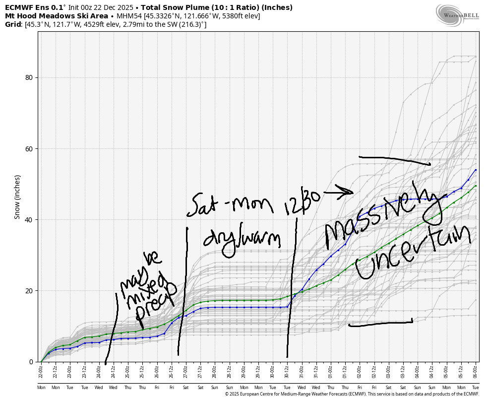
Taking a bird’s eye view of the next week or so, we have a few inches of snow tonight. During the Wednesday through Friday time period, there are times when the incoming precipitation will be cold enough for snow, and there are other periods that are likely to result in mixed precipitation, rain, or freezing rain. Next weekend brings dry, sunny weather to the slopes. Uncertainty skyrockets late next Monday (the 30th), so I’m going to pass on making guesses about the extended time frame.
Short term Mt Hood snow forecast
Diving in to today (Monday), we have lingering flurries early in the morning, partly cloudy sky for much of the day, and a few inches of snow overnight. The snow level will be 2000′ early, 4000′ this afternoon, and 2000′ (if you believe the sounding model) to 4000′ (going by the 0C temps at 850mb) overnight. We’re expecting about 0.3” water equivalent (WE) for about 3” of moderate density snow. Wind: WSW 15-20 this morning, SW 15-30 this afternoon, SW 20-40 late tonight, and SW 10-15 after midnight.
A few flurries on Tuesday give way to a brief clear period then high clouds. Overnight, light mixed precip is forecast. The snow level will be 2000′ in the morning, 6000′ in the evening, and 8000′ after midnight. There is a brief period of intense precip around 10pm that could result in wet snow all the way down to 1500-2000′, but that won’t last; temps at 850mb (~5000′) rise as high as +7C overnight, depending on location. Luckily, we’re only expecting 0.1” to 0.2” WE. Call it little to no accumulation. Wind: SW 10-15 in the morning, S15-30/E25 depending on elevation in the evening, and S 30-50 overnight.
Snow continues on Wednesday with the snow level around 2000′. As of right now, we’re looking at 0.3” to 0.4” WE for 3-5” relatively light new snow. Wind: WNW 55 early, W 30 in the afternoon, and SSW 10-20 after midnight. We could see enhanced snowfall and higher totals early thanks to the very strong WNW wind.
Extended Mt Hood Snow Forecast
Models are all over the place on the exact details for Wednesday. Generally speaking, some sort of system swings north along the coast. While it will bring at least some precipitation, ti’s also going to bring periods of warm air. 850Mb temps bounce around between -1C and +2C. This is likely to result in mixed precip with some potential for freezing rain. Wind on Wednesday could be quite strong out of the S/SW or even WSW – not as strong as the last couple of systems, but still quite breezy.
Extended: light mixed precip or potentially snow is forecast Thursday into Friday. By Saturday, a ridge arrives. We’re looking at warm, sunny conditions for a few days. Models are uncertain when this ridge will break down; starting Monday, uncertainty is quite high with over 10C of range in the 5000′ temps. Generally speaking, the temps look to be on a downward trend after Monday, and precip looks to be on an upward trend. Let’s cross our fingers for now and leave the forecast at that. Hope to see you on the snow soon!
Was that helpful? I knew it was! Guess what? All of this crucial work – from your personal wind and snow reports to the invaluable TATAS updates – is made possible by my relentless efforts. Maintaining this labor of love isn’t easy. Each daily forecast takes hours. Website hosting, weather model access, and back-end admin work takes time and money. That’s where you come in.
YOUR CONTRIBUTION MAKES A DIFFERENCE
- SUPPORT ACCURATE, HYPER-LOCAL WEATHER FORECASTING
- ENABLE ACCESS FOR ALL, EVEN THOSE WITH LESS MEANS
- SUPPORT A COOL HUMAN WHO WORKS HARD SO YOU CAN PLAY
Take a moment to click one of the buttons below. Donate $19.99 or more (how much does this forecast enhance your life?) and get the email in your inbox. Whether it’s a renewing subscription (auto-renew) or a one-time donation, every contribution makes a real difference. Help me keep this labor of love alive, so we can all continue playing, commuting, and living in the Gorge with peace of mind and the best weather forecasts possible. Thank you!


Hood River, Oregon 97031


GORGE WIND FORECAST
If you’re still seeing yesterday’s and it’s after 9am, try opening this in an incognito window
SHORT-TERM gorge wind forecast
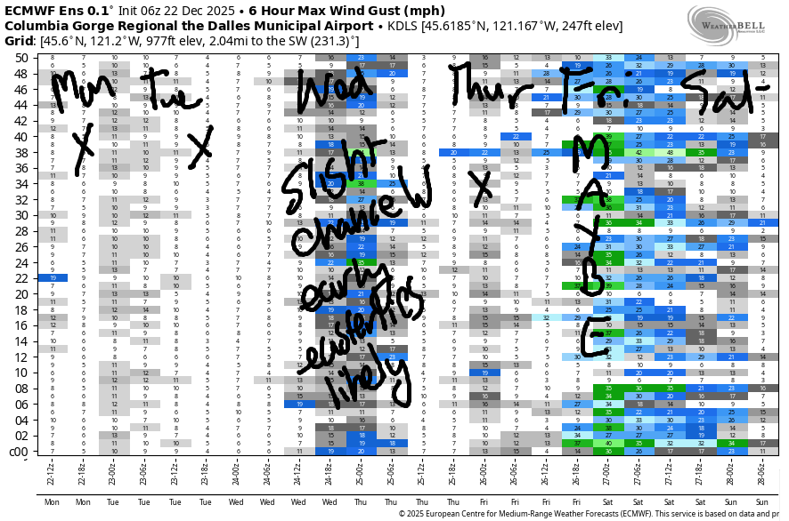
Hi friends! Active weather continues – at least a couple of low pressure systems moving along the coast and potentially inland give us wind from various directions. Most notable is a system on Wednesday that’s surrounded by uncertainty. Looking deeper into the future, there’s a chance of westerlies on Friday as a front swings inland and high pressure builds behind it. Fingers crossed on that one!
Looking at Monday morning, we have very light offshore gradients to start. Easterlies rise to 10mph at Iwash (Rooster) Rock and 15-20mph at Stevenson by late morning and hold into the afternoon. Overnight, the wind turns westerly at 12-15mph, but it’ll be dark outside, and you’ll be asleep. River flow over the last 24 hours was 192-216kcfs, river temp is 48.4F, and high temp forecast is 44F and (eventually) partly cloudy.
Tuesday starts calm or very light easterly. In the afternoon, easterlies rise to 25mph at Iwash Rock and 20-25mph at Stevenson. High temp: 43F and cloudy. Watch for debris in the river, and take the current into account.
RIVER FLOW FOR SITES BETWEEN AVERY (EAST OF THE DALLES) AND RUFUS: CLICK HERE FOR JOHN DAY DAM FLOW.
RIVER FLOW FOR SITES BETWEEN STEVENSON AND DOUG’S BEACH (WEST OF THE DALLES): CLICK HERE FOR THE DALLES DAM FLOW

LONGER-TERM gorge wind forecast
Wednesday has a lot of uncertainty. It’s possible a compact and powerful low will form somewhere between the coastal waters and the Cascades. If it forms, it will move north. IN response, we’ll have moderately strong easterlies followed by the possibility of westerlies. It’s almost certain, given the low’s path, that westerlies will be confined to areas west of the Hatch. Out in the desert: strong S to SW wind is possible. IN other words, it’s unlikely we’ll see westerly windsport wind out of this one, but it’s not impossible. Easterlies are more likely, but they’ll be accompanied by rain. High temp: 45F.
Easterlies continue at 20-25mph or so on Thursday (probably). Our next best chance for windsport westerlies is Friday. Models are somewhat hopeful, and so am I. We’re not talking about a nuker, but we are talking about enough for foil sports. Okay, that’s it for now. Have an awesome day!
BARE BONES HOOD RIVER WEATHER FORECAST
Drizzle early, dry much of the day with partly cloudy sky, rain this evening. Temps start in the mid 30s and rise to the mid 40s. Light east wind all day. Light west wind overnight. 61% chance of rainbows. Tuesday will be drizzly before sunrise, dry midday, and rainy in the evening. Temps start in the upper 30s and rise to the low 40s. Calm wind early. Light easterlies later. 16% chance of rainbows. Wednesday will be partly cloudy with rain overnight. Temps start in the mid 30s and rise to the mid 40s. Light easterlies in the morning. Light westerlies** (see TATAS) later. No rainbows.
TEMIRA’S AWESOME TRAVEL ADVISORY SERVICE
HYPERLOCAL WEATHER FORECAST FOR THE COLUMBIA GORGE
THE DALLES, HOOD RIVER, WHITE SALMON, TROUT LAKE, STEVENSON, CASCADE LOCKS, PARKDALE, ODELL, HUSUM, BZ, MILL A, WILLARD, GOLDENDALE, RUFUS, ARLINGTON, boardman
Good morning, neighbors! Happy winter to all of you! We’ll get something like 4 seconds more daylight today. If you are fully, completely present with it, it will feel like a lifetime. Go for it! Make the most of it! Upcoming weather doesn’t have much action. One exception is Wednesday when a system might/might not result in strong southerly wind in Wasco, Sherman, and Gilliam Counties. Maybe.
Glenwood this morning
Looking around the Gorge this morning, we’ve got Glenwood at 32F, Dufur at 29F, and most other folks in the mid 30s. The Nothing has devoured Underwood. It’s gone. Highway 35 remains closed south of Cooper Spur road thanks to that landslide at the S-Curves. Beyond that, it’s chains required on 35/26 thanks to actual honest-to-god mountain snow last night. Other than that, roads appear to be clear of ¡CE this morning. May they stay that way!
Today’s Gorge weather forecast
Weather today: after a cloudy start to the west and clear sky to the east, we’ll see a period of at least partly cloudy sky for all. Another round of rain arrives this evening as far east as Mosier with a downpour near Cascade Locks in the 7pm to 10pm time period. Temps max out in the mid 40s today everywhere in the lowlands. Wind: east 15-20mph in the usual east wind spots. Light elsewhere.
Tuesday’s Gorge weather forecast
Tuesday starts with a bit of drizzle as far east as Mosier, but that should be done by sunrise. Rest of the day: mostly cloudy with high temps in the 43-44F zone. Rain returns from the SW in the evening and extends all the way from Cascade Locks to Hermiston. Wind: calm in the morning, E 20-25mph in the afternoon near Stevenson and Iwash (schlong) Rock.
Wednesday’s Gorge weather forecast
Things get more interesting on Wednesday as a potentially strong system potentially forms into a low and potentially brings a windstorm to the Valley of Willies. Out here in the Gorge, we could see moderately strong west wind west of Underwood with strong south wind in Wasco, Sherman, and Gilliam Counties in the evening. Models agreement is too low at this point to hazard a precise forecast, so I won’t. Let’s try again tomorrow! Temps Wednesday: mid 30s to start, mid 40s to finish. Wind will (probably) be strong easterly near Stevenson and Iwash (dick) Rock for the morning hours.
Extended Gorge weather forecast
In the extended forecast, we have light/intermittent rain on Thursday and Friday. High pressure (dry weather) builds in Saturday and continues through at least Monday. An inversion is almost certain to develop. Its strength will determine the presence/lack of The Nothing. That seems like enough forecast for now. Safe travels. -TATAS
HEY! DON’T STOP READING! Is this community-focused forecast helpful to you? It sure is! It takes me a couple hours a day to write. Please join your friends and neighbors in contributing to keep it going. Venmo: @thegorgeismygym PayPal: twomirrors@gmail.com USPS: Temira / PO Box 841 / Hood River, Oregon 97031 You can test out the forecast subscription for a few days for free by signing up below. Easy! Do it!
JONES BEACH, SAUVIE ISLAND, & COAST FORECAST
ON WINTER VACATION UNLESS DESPERATELY NEEDED.
