

MT HOOD SNOW FORECAST

Hi skiers and snowboarders! I woke up late this morning – still trying to find that lost hour. Upcoming this week – wild weather for Mt Hood as a westerly atmospheric river takes aim at our beloved volcano. In the past, an AR from this direction would have been a sure thing for massive snowfall; with climate change warming, this storm will be right on the edge for snow at 5000′. Generally speaking, we’ll have light snowfall and cool temps through Wednesday morning.
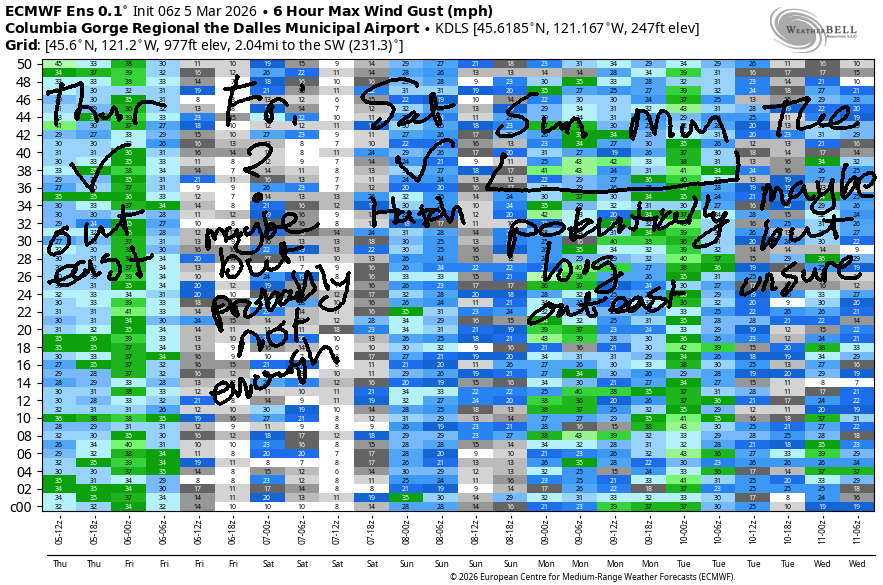
The Big System arrives Wednesday daytime. Along with significant moisture, we’ll have very strong wind Wednesday and Thursday and potentially Friday as well. Lift ops will be questionable all three days.
Short term Mt Hood snow forecast
But not Monday. Monday brings light snowfall top to bottom at all the resorts. Snowfall picks up overnight. The snow level will be around 2000′ all day, and it’ll fall as low as 0′ near Mt. Hood overnight. About an inch of new snow is forecast during the day. Overnight, we’re expecting 0.3” to 0.4” water equivalent (WE) for 3-5” fresh powder. Wind will be WNW 30-40 early, WE 20 in the afternoon, and NW 25-30 after midnight. Snow surface will be powder accumulating over scoured frozen granular.
Tuesday starts sunny and adds a few clouds midday. Flurries are possible in the afternoon, and they’re followed by light, steady snowfall overnight. The snow level will be 0′ in the morning, 2000′ in the afternoon, and 1500′ (but warming) overnight. A trace is expected in the afternoon followed by 0.2” WE for a couple inches of increasingly dense snow overnight. If we get the expected snow Monday night, Tuesday’s surface conditions will have at least some packed powder. Wind: NW 25-30 early, WSW 20-30 in the afternoon, and WSW 30-45 after midnight.
Extended Mt Hood Snow Forecast
Storm intensity ramps up on Wednesday as the jet stream takes aim at the PNW. The snow level starts around 4000′ and slowly rises to 6000′ (850mb temps at +2C) before falling back to 4500′ (850mb temps at 0C) overnight. During the day, 1.2” WE is forecast for 7-10” of dense new snow. That could switch to mixed precip in the evening for a while and may continue as mixed precip overnight. That said, precip intensity could keep it wet snow. We’re expecting 2.2” WE overnight. If that’s snow, it’s 15-20” wet snow. Also likely given the temperature variations and accompany wind: significant icing of lifts and inability to run lifts. Wind will be WSW 45 early, W 50 midday, WSW 55-65 in the afternoon, and W 55 overnight. The most likely period of shutdown is during that W 50 period… WSW is a little easier for lifts to handle.
Thursday starts with marginal temps, strong wind, and heavy precip. The snow level will be around 4500-5500′ (850mb temps at 0C) early, 6000′ in the afternoon (850mb temps at +2C), and will hold somewhere between 4000′ and 8000′ overnight as an isothermal environment develops. We’re expecting 1.4” WE during the day for 8-12” dense snow. That’s followed by 0.3” WE overnight for a couple more inches. Lifts are unlikely Thursday as the wind holds at W 55 all day long and only drops to W 50 overnight. As of this morning, a rain n’ wind combo with zero lifts is on tap for Friday. Precip tapers off and temps drop early Saturday. I’ll leave this here for now other than some comments…
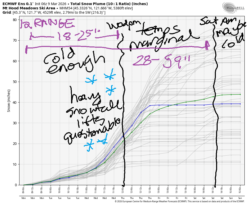
This system is going to be right on the edge for rain/snow. Given the direction and quantity of moisture, I suspect we’ll (mostly) stick with dense snowfall rather than pouring rain. Models still have quite a bit of range in how much moisture they’re expecting, but they’re currently calling for 7-9” of much-needed water equivalent through Sunday. Through Thursday morning, when temps start to rise, the intraquartile snowfall range is 18-25”. Through Saturday (when it’s relatively cool), the range is 28-59”. Run-to-run, the Euro ensemble has been shifting towards higher snow totals. Fingers crossed! And again, I emphasize the strength of the wind Wednesday through Friday – do check the resort websites for lift ops info before driving up, as ops are almost certain to be affected. Okay. Fingers crossed again for at least a couple feet of snow from this system! Hope to see you out there for some storm skiing!
Was that helpful? I knew it was! Guess what? All of this crucial work – from your personal wind and snow reports to the invaluable TATAS updates – is made possible by my relentless efforts. Maintaining this labor of love isn’t easy. Each daily forecast takes hours. Website hosting, weather model access, and back-end admin work takes time and money. That’s where you come in.
YOUR CONTRIBUTION MAKES A DIFFERENCE
- SUPPORT ACCURATE, HYPER-LOCAL WEATHER FORECASTING
- ENABLE ACCESS FOR ALL, EVEN THOSE WITH LESS MEANS
- SUPPORT A COOL HUMAN WHO WORKS HARD SO YOU CAN PLAY
Take a moment to click one of the buttons below. Donate $19.99 or more (how much does this forecast enhance your life?) and get the email in your inbox. Whether it’s a renewing subscription (auto-renew) or a one-time donation, every contribution makes a real difference. Help me keep this labor of love alive, so we can all continue playing, commuting, and living in the Gorge with peace of mind and the best weather forecasts possible. Thank you!


Hood River, Oregon 97031


GORGE WIND FORECAST
If you’re still seeing yesterday’s and it’s after 9am, try opening this in an incognito window
SHORT-TERM gorge wind forecast
Hi friends! Hopefully those of you who were at Rufus and areas farther east had a great time yesterday. And it was fun riding with the folks who caught the unexpected session mid-afternoon at the Hatch. We’ll have additional opportunities for westerlies this week, most notably Saturday but also Wednesday and Thursday.
Monday started with pressures of 30.13/30.03/29.88 for gradients of 0.10/0.05. Models suggest the pressures will drop west of The Dalles by late morning and leave us with 10-13mph. From Avery to Hermiston, we’ll have gusty 20-23mph pretty much all day. The wind fades after 5pm. River flow over the last 24 hours was 180-197kcfs (185-197 at Rufus), river temp is 43.9F, and high temp forecast is 46F and partly cloudy.
RIVER FLOW FOR SITES BETWEEN AVERY (EAST OF THE DALLES) AND RUFUS: CLICK HERE FOR JOHN DAY DAM FLOW.
RIVER FLOW FOR SITES BETWEEN STEVENSON AND DOUG’S BEACH (WEST OF THE DALLES): CLICK HERE FOR THE DALLES DAM FLOW

LONGER-TERM gorge wind forecast
Tuesday brings lesser wind. The day starts with 7-10mph all through the Gorge and rises to 10-13mph all through the Gorge. High temp: 47F with morning clouds to the west and sun out east. By afternoon, the whole Gorge will be cloudy.
More “interesting” weather arrives on Wednesday as the jet stream takes aim at the Pacific Northwest. This, and associated impulse, sets us up for periods of moderately strong to strong westerlies. Viento tends to nuke with this setup, and sometimes the associated wind will extend to the Hatch. Also benefiting from strong W wine aloft is the Rufus-Arlington zone, but it’ll be extra gusty. On Wednesday, we’ll have gusty 20-25 in the afternoon near the Hatch with gusty 24-28 near Rufus.
Somewhat lesser wind is likely Thursday. Models suggest you keep an eye on the Hatch and Rufus Friday and also Saturday, but that’s a long ways out and the details are unclear. Ensembles insist that something exciting will happen in wind world on Saturday, so clear that day if you can. Hope to see you on the river soon for foiling!

BARE BONES HOOD RIVER WEATHER FORECAST
Partly cloudy sky today. Drizzle this evening. Temps start in the low 40s and rise to the mid 40s. Moderate westerlies. No rainbows. Tuesday may start with a few snow flurries. Rain arrives in the afternoon. Temps start in the low 30s and rise to the upper 40s. Light westerlies. 18% chance of rainbows. Wednesday will be rainy. Temps start in the mid 30s and rise to the low 50s. Calm wind early. Moderate westerlies later. 99% chance of rainbows.
TEMIRA’S AWESOME TRAVEL ADVISORY SERVICE
HYPERLOCAL WEATHER FORECAST FOR THE COLUMBIA GORGE
THE DALLES, HOOD RIVER, WHITE SALMON, TROUT LAKE, STEVENSON, CASCADE LOCKS, PARKDALE, ODELL, HUSUM, BZ, MILL A, WILLARD, GOLDENDALE, RUFUS, ARLINGTON, boardman

Good morning, neighbors! A brief spell of winter is planned tonight. That’s followed by an impressive westerly atmospheric river that will absolutely soak (no, not that kind of soaking) the western Gorge and the Cascades Wednesday through Friday and potentially briefly again over the weekend. Y’all better cross your fingers right now that temps remain just-cold-enough in the Cascades – we have the opportunity here to make an impact on our sad-ass snowpack.
Glenwood this morning and today’s Gorge weather forecast
Glenwood’s not making an impact (or impression) on anyone this morning – it’s merely 34F there and boring. Also boring: the roads. Not much ice, and no !CE. Looks like folks above 1500′ may have picked up a trace of snow last night – Underwood Mountain has a trace. Some areas will pick up some snow tonight. More on that in a minute. Monday will be increasingly cloudy after a partly cloudy start. Drizzle arrives for Cascade locks from 11am to 5pm.
That’s followed by another, colder system tonight. 1-2” of snow are possible for Mill A, Willard, Underwood, Trout Lake, York Hill, Parkdale, Husum, and associated areas. Lower elevations and also areas west of Rowena could see a trace to an inch. South Wasco: a trace to an inch. High temps Monday will be in the mid 40s (west), upper 40s (The Dalles), and low 50s (The Desert). Snow level: 2000′ during the day falling to 0-500′ tonight. Wind will be W 10-15mph west of The Dalles with 15-25mph east of The Dalles to Hermiston.
Tuesday’s Gorge weather forecast
A few lingering flurries or sprinkles give way to dry, cloudy weather Tuesday morning, when temps will be right around 32F in the lowlands. The next system brings rain as far east as Cascade Locks by 2pm. Intensity increases into the evening and rain extends as far east as Rowena in the lowlands and Appleton in the highlands. Max temps will be in the upper 40s to low 50s. Wind will be westerly at 10mph. As of this morning’s forecast, the snow level looks to stay above 1500′ on Tuesday night. This puts a few of you (Willard, Trout Lake, Parkdale, Underwood, Snowden) at risk for some snowfall, but other folks just get rain.
Extended Gorge weather forecast
By Wednesday morning, we’ll have pouring rain west of Hood River. That’ll fuck up your commute! Lighter rain extends as far east as Mosier or Lyle in the lowlands and High Prairie or Centerville on the WA side highlands. Max temps will be 50F to the west, 55F near The Dalles, and 60F out in the desert. This setup continues all the way through Saturday morning with the exception of several hours of lighter rain or even a dry period on Friday morning. Accompanying this will be moderately strong to strong west wind, especially up in the mountains. Driving to or from the metro area between Wednesday and Saturday? Expect pouring rain for most of that time period with the possible exception of Friday morning.
Uncertainty rises this weekend, but it does look super windy and potentially slightly colder on Saturday. We start a warmer, mostly-dry pattern on Sunday, although uncertainty is pretty high around specific temps. That’s all I’ve got for you now. Safe travels. -TATAS
HEY! DON’T STOP READING! Is this community-focused forecast helpful to you? It sure is! It takes me a couple hours a day to write. Please join your friends and neighbors in contributing to keep it going. Venmo: @thegorgeismygym PayPal: twomirrors@gmail.com USPS: Temira / PO Box 841 / Hood River, Oregon 97031 You can test out the forecast subscription for a few days for free by signing up below. Easy! Do it!
JONES BEACH, SAUVIE ISLAND, & COAST FORECAST
ON WINTER VACATION UNLESS DESPERATELY NEEDED.

Leave a Reply