

MT HOOD SNOW FORECAST

Hey skiers and snowboarders! Sunday was an excellent spring skiing day. Looks like temps dropped low enough this morning for a repeat of corn snow today. We move into a rainy period midday on Tuesday. It’s possible we’ll pick up a little bit of snow at the tail end of this system. Looking deeper into the future, we have another warm spell at the end of this week.
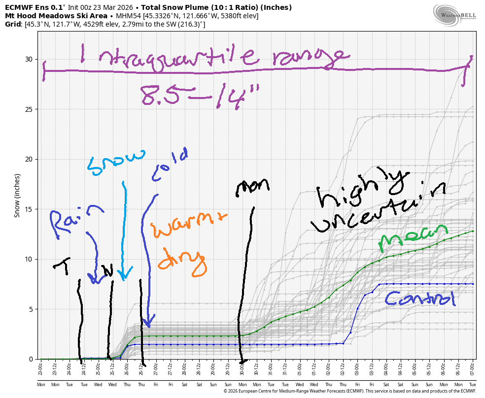
Uncertainty skyrockets at the end of the weekend. The spaghetti model suggests we could pick up some snow in the following week, but honestly, the vast majority of the ensemble members (despite the snow in the spaghetti model) keep temps above freezing at 5000′. Through April 7th, the intraquartile range for snowfall is 8.5-14”.
Short term Mt Hood snow forecast
Today, Monday, brings high clouds and above-freezing temps. The free air freezing level will be 8000′ in the morning, 9000′ in the afternoon, and 11,000′ overnight. Temps at 5000′ max out around 40F. We’re not expecting any precipitation. Wind will be under 15mph all day. It’ll rise to WSW 30-40 after midnight. Snow surface will be frozen or loose granular early and corn snow pretty quickly.
After a cloudy start to Tuesday, rain arrives mid-morning. It’ll transition to snow after 8pm, but most of the precip will be done by then. The snow level will be 11,000′ early, 10,000′ when the rain arrives, 7000′ in the evening, and then it will fall to 2500′ by early Wednesday. We’re expecting about 0.7” rain prior to 5pm. Between 5pm Tuesday and Wednesday 5am, we’re expecting 0.5” water equivalent (WE) mixed precipitation. That gives us 2-3” wet snow if we’re lucky. Wind will be WSW 30-40 in the morning, SW 30-50 from noon on through the evening, and W 35 after midnight.
Extended Mt Hood Snow Forecast
Wednesday starts with some orographic (terrain-driven) snow flurries. Another weak system arrives mid-morning for a little snow. Overnight, the sky clears. The snow level will be 2500′ all day, and the free air freezing level will fall to 1000′ overnight. Up to 2” new snow is forecast during the day. Wind will be W 35 in the morning, W 30 in the afternoon, and WNW 15-25 after midnight. That wind is likely to shut down the highest lifts, but most lifts will be just fine.
Thursday will be sunny and cool. The free air freezing level starts around 1000′, rises to 3000′, and drops to 2500′ after midnight. No precip. Wind will be WNW 15-25 in the morning, light westerly in the afternoon, and E 15-20 overnight. Friday looks sunny and warm with temps pushing to almost 40F. Saturday adds some clouds. Beyond that… uncertainty rises. That’s all I’ve got to say today. Enjoy the spring skiing conditions!
Was that helpful? I knew it was! Guess what? All of this crucial work – from your personal wind and snow reports to the invaluable TATAS updates – is made possible by my relentless efforts. Maintaining this labor of love isn’t easy. Each daily forecast takes hours. Website hosting, weather model access, and back-end admin work takes time and money. That’s where you come in.
YOUR CONTRIBUTION MAKES A DIFFERENCE
- SUPPORT ACCURATE, HYPER-LOCAL WEATHER FORECASTING
- ENABLE ACCESS FOR ALL, EVEN THOSE WITH LESS MEANS
- SUPPORT A COOL HUMAN WHO WORKS HARD SO YOU CAN PLAY
Take a moment to click one of the buttons below. Donate $19.99 or more (how much does this forecast enhance your life?) and get the email in your inbox. Whether it’s a renewing subscription (auto-renew) or a one-time donation, every contribution makes a real difference. Help me keep this labor of love alive, so we can all continue playing, commuting, and living in the Gorge with peace of mind and the best weather forecasts possible. Thank you!


Hood River, Oregon 97031


GORGE WIND FORECAST
If you’re still seeing yesterday’s and it’s after 9am, try opening this in an incognito window
SHORT-TERM gorge wind forecast
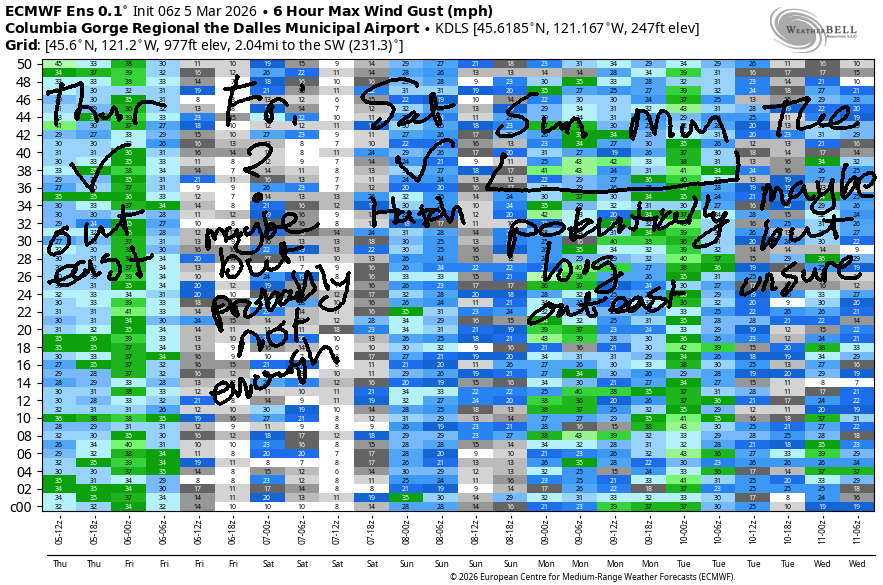
Hi friends! Light westerlies are planned for Monday and Tuesday. Models give us a better chance of a stronger day on Wednesday out in the desert. Not much happens on Thursday, but ensembles like the idea of a stronger easterly day on Friday.
Monday starts with pressures of 30.12/30.11/30.10 for very light onshore gradients. Wind was light and variable to start the day. A slight onshore temp gradient this afternoon gives us westerlies at 12-15mph from Stevenson to The Dalles. River flow over the last 24 hours was 244-265kcfs, river temp is 46.0F, and high temp forecast is 61F with increasing clouds.
RIVER FLOW FOR SITES BETWEEN AVERY (EAST OF THE DALLES) AND RUFUS: CLICK HERE FOR JOHN DAY DAM FLOW.
RIVER FLOW FOR SITES BETWEEN STEVENSON AND DOUG’S BEACH (WEST OF THE DALLES): CLICK HERE FOR THE DALLES DAM FLOW

LONGER-TERM gorge wind forecast
Tuesday starts light and variable. A cold front swings inland and allows a nice temp gradient to develop, but other factors are not supportive. The day starts light/variable. Afternoon brings a slow build to 14-17mph from Stevenson to Doug’s with 21-24 from Rufus to Arlington. High temp: 57F to the west and 63F out east with drizzle all the way into the desert after 2pm and drizzle west of The Dalels all day.
That system clears the area on Wednesday and is quickly followed by another, weaker system. Suggestion: let those systems move through, and wait for the afternoon; morning wind will be under 10mph west of The Dalles and 12-15mph to the east of The Dalles. After 2pm, Stevenson to Doug’s rises to gusty 12-15. Between Avery and Boardman, westerlies rise to 27-30mph. Strongest wind (currently) is forecast between 2pm and 5pm with a fade later. High temp: 52F in Hood River and upper 50s in the desert with sunshine in the afternoon out east. Keep in mind that the river flow is quite high at Rufus.
Thursday’s forecast is currently for calm wind early and light easterlies in the afternoon. Cool air in the desert on Friday morning combines with a developing heat low in the Willamette Valley. Forecast: E 40mph. Saturday starts with strong easterlies but fades quickly and ends dead calm. Beyond Saturday, uncertainty is too high to make predictions. Have fun on the Nch’i Wana – I hope to see you out there soon!

BARE BONES HOOD RIVER WEATHER FORECAST
High clouds today. Temps start in the mid 30s and rise to the low 60s. Light to moderate westerlies. No rainbows. Tuesday will be dry early and rainy from mid-morning on. Temps start in the low 40s and rise to the upper 50s. Light westerlies. 99.9% chance of rainbows. Wednesday will be mostly cloudy. Temps start near 40 and rise to the low 50s. Drizzle midday. Light westerlies. 99% chance of rainbows.
TEMIRA’S AWESOME TRAVEL ADVISORY SERVICE
HYPERLOCAL WEATHER FORECAST FOR THE COLUMBIA GORGE
THE DALLES, HOOD RIVER, WHITE SALMON, TROUT LAKE, STEVENSON, CASCADE LOCKS, PARKDALE, ODELL, HUSUM, BZ, MILL A, WILLARD, GOLDENDALE, RUFUS, ARLINGTON, boardman
Good morning, neighbors! Nothing to see here… other than spring! My friend’s Bing cherry tree had an open blossom on it yesterday… things are marching right along here to the beat of April. Headlines for the week include rain on Tuesday, enough for an unpleasant city/country commute, and a little drizzle on Wednesday. Then we’re back to relatively warm and totally dry weather for a few days. Our best chance of frost is Thursday morning…
Glenwood this morning
Speaking of frost, there’s frost in Glenwood this morning: it’s 25 degrees there. Other cool areas (Parkdale, Trout Lake, Dufur) are generally running 29-33F. Along the Nch’i Wana: upper 30s to mid 40s.
Today’s Gorge weather forecast
It is Monday today, all day long. We’re expecting increasing clouds. High temps: 61-64F in the lowlands. Clouds extend all the way out into the desert this afternoon. Wind will be light and variable this morning. It picks up to 10-15mph between Stevenson to The Dalles this afternoon with lighter wind out east.
Tuesday’s Gorge weather forecast
We all start cloudy on Tuesday. Rain arrives around 11am to Hood River and extends all the way past the Tri-Cities by 2pm. South Wasco, Sherman, and Gilliam Counties see some drizzle mid-afternoon. Rain pretty much ends by 8pm except near Cascade Locks, where drizzle continues all night. No surprise there! Driving to/from the metro area Tuesday? Expect heavy rain west of Hood River from 11am to 8pm. Despite all this rain, temps stay relatively warm: 57F to the west, 62F (The Dalles), and 64F (the desert). Wind starts light/variable and rises to 10-15mph west of The Dalles and 15-25mph east of The Dalles.
Wednesday’s Gorge weather forecast
Overnight into Wednesday, the snow level falls to around 2500′. A few of you could see some flurries, but sticking snow is unlikely. Early in the day, The Dalles will be partly cloudy. The rest of us, to the east, west, north, and south, start the day under clouds. Drizzle returns mid-morning and sticks around as far east as The Dalles (Biggs too for a couple hours) until late afternoon. Thanks to strong offshore high pressure, areas east of The Dalles will be windy: 25-30mph in the afternoon. To the west: 10-15mph. Max temps will be low 50s to the west, mid 50s in the The Dalles, and 60F in the desert.
Extended Gorge weather forecast
Sunny, mid-50s, calm-wind weather is forecast on Thursday. Given the clear, calm start combined with 850mb (~5000′) temps at -6C, frost is likely all the way down to the Nch’i Wana (big river). It’s possible we’ll see icy roads as well. Leave a little extra time for your drive on Thursday morning just in case. Friday looks sunny and warmer. Ditto Saturday. Model agreement falls apart on Sunday, but there’s nothing even vaguely concerning in the extended forecast. There is, thankfully, at least a little rain. Safe travels. -TATAS
HEY! DON’T STOP READING! Is this community-focused forecast helpful to you? It sure is! It takes me a couple hours a day to write. Please join your friends and neighbors in contributing to keep it going. Venmo: @thegorgeismygym PayPal: twomirrors@gmail.com USPS: Temira / PO Box 841 / Hood River, Oregon 97031 You can test out the forecast subscription for a few days for free by signing up below. Easy! Do it!
JONES BEACH, SAUVIE ISLAND, & COAST FORECAST
ON WINTER VACATION UNLESS DESPERATELY NEEDED.

Leave a Reply