

MT HOOD SNOW FORECAST

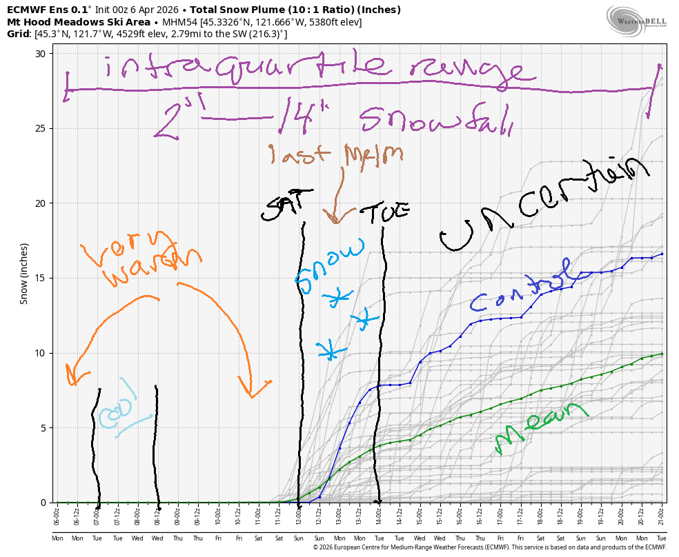
Hey skiers and snowboarders! Another sunny and (mostly) dry week is on tap for Mt. Hood. In an ironic twist, cooler temps and a little snow are likely for closing weekend at Mt Hood Meadows. Beyond next Sunday, uncertainty is quite high – the range for 850mb temps is 0-8C (approximately) through the 21st of the month, the end of this particular model run. In other words, no conclusions can be drawn, but snow is an unlikely outcome beyond next Monday.
Short term Mt Hood snow forecast
This Monday kicks off sunny with temps in the mid 40s to start the day. The free air freezing level (FAF) hovers near 10,000′ all day before dipping to 9000′ overnight. Temps max out in the upper 40s to low 50s at 5000′. Wind will be light westerly early, W 20-25 in the afternoon, and W 35-40 after midnight. Snow conditions: sounds like there was a light freeze, but it’ll quickly turn slush. Note: Meadows has opened Superbowl for hiking the last couple of days, so carry your hiking gear and water if that’s something you enjoy. The window of opportunity will be small due to warming, so attempt it early if they open it!
Tuesday will be clear. The free air freezing level will be as high as 8500′ early, but it’ll fall to 6000′ in the afternoon and 4000′ overnight with the passage of a dry cold front. Temps at 5000′ fall to the low 30s. Wind will be W 35-40 early, WNW 15-20 in the afternoon, and variable to 10 overnight.
Extended Mt Hood Snow Forecast
Wednesday also looks sunny, and may be the best skiing of the week thanks to an overnight freeze. The free air freezing level will be 4000′ early, 6500′ in the afternoon, and 8000′ overnight. Temps max out in the mid to upper 30s. Wind will be light and variable all day. Thursday: warmer (40 degrees), sunny, and light wind. Ditto Friday, when temps will max out in the upper 40s with sunshine and light wind.
Looking at the weekend, we have a weak system on Saturday that brings a little rain followed by a little snow. Light snowfall is forecast on Sunday, which happens to be the last day Meadows is open this season. Have fun out there today in the sun and snow!
Was that helpful? I knew it was! Guess what? All of this crucial work – from your personal wind and snow reports to the invaluable TATAS updates – is made possible by my relentless efforts. Maintaining this labor of love isn’t easy. Each daily forecast takes hours. Website hosting, weather model access, and back-end admin work takes time and money. That’s where you come in.
YOUR CONTRIBUTION MAKES A DIFFERENCE
- SUPPORT ACCURATE, HYPER-LOCAL WEATHER FORECASTING
- ENABLE ACCESS FOR ALL, EVEN THOSE WITH LESS MEANS
- SUPPORT A COOL HUMAN WHO WORKS HARD SO YOU CAN PLAY
Take a moment to click one of the buttons below. Donate $19.99 or more (how much does this forecast enhance your life?) and get the email in your inbox. Whether it’s a renewing subscription (auto-renew) or a one-time donation, every contribution makes a real difference. Help me keep this labor of love alive, so we can all continue playing, commuting, and living in the Gorge with peace of mind and the best weather forecasts possible. Thank you!


Hood River, Oregon 97031


GORGE WIND FORECAST
If you’re still seeing yesterday’s and it’s after 9am, try opening this in an incognito window
SHORT-TERM gorge wind forecast
Hi friends! It’s a beautiful and not-very-windy morning here in the Gorge, but we have westerlies on tap late today and all day Tuesday. Wednesday through Friday don’t hold much opportunity for wind sports, but it’s possible we’ll see westerlies this weekend as the weather turns more active.
Looking at Monday morning…. we started with light east gradients. The wind will be calm or light easterly this morning. By early afternoon, westerlies rise to 12-15mph from Stevenson to The Dalles. Give it a little longer, and we’ll have 15-18 from Stevenson to Mosier with gusty 22-25mph from Lyle to Arlington, likely strongest at Rowena and Doug’s. River flow over the last 24 hours was 201-222kcfs, river temp is 47.8F, and high temp forecast is 78F.
RIVER FLOW FOR SITES BETWEEN AVERY (EAST OF THE DALLES) AND RUFUS: CLICK HERE FOR JOHN DAY DAM FLOW.
RIVER FLOW FOR SITES BETWEEN STEVENSON AND DOUG’S BEACH (WEST OF THE DALLES): CLICK HERE FOR THE DALLES DAM FLOW

LONGER-TERM gorge wind forecast
A dry cold front swings through the Gorge on Tuesday and leaves us with relatively strong offshore high pressure. Models suggest some morning low clouds in the western Gorge followed by a clear afternoon. Daybreak gives us 21-24mph (maybe more if we’re lucky) for TJ’s Dawn Patrol from Viento to Mosier with 13-16mph near Rowena and 23-26mh from Avery to Arlington. Eastern Gorge sites back off quickly as sunshine takes over. Afternoon wind looks like 22-25mph from Stevenson to Avery with 15-18mph at Rufus. After 5pm, the wind drops to 15-18mph for all the aforementioned locations. High temp: 60F with clouds early and sun in the afternoon.
Wednesday, Thursday, and Friday all look light and variable. Temps rise from 66F on Wednesday to 69F Thursday and 71F on Friday with mostly clear sky.
A weather system is likely on Saturday. Ensembles are all over the place on the evolution of the pattern. About 50% of the ECMWF ensemble members give us a solid westerly day, and the same is true for Sunday and Monday. Fingers crossed!!! Hope to see you on the Nch’i Wana soon!

BARE BONES HOOD RIVER WEATHER FORECAST
Clear sky this morning. A few high clouds later. Temps start in the mid 40s and rise to the upper 70s. Calm wind early. Moderate westerlies later. No rainbows. Tuesday will be partly cloudy then mostly clear. Temps start in the mid 40s and rise to 60 or so. Moderately strong westerlies. No rainbows. Wednesday will be mostly clear then clear. Temps start in the mid to upper 30s and rise to the mi d60s. Calm wind early. Light/variable wind later. No rainbows.
TEMIRA’S AWESOME TRAVEL ADVISORY SERVICE
HYPERLOCAL WEATHER FORECAST FOR THE COLUMBIA GORGE
THE DALLES, HOOD RIVER, WHITE SALMON, TROUT LAKE, STEVENSON, CASCADE LOCKS, PARKDALE, ODELL, HUSUM, BZ, MILL A, WILLARD, GOLDENDALE, RUFUS, ARLINGTON, boardman
Good morning, neighbors! Mild to hot, sunny weather is in the cards all week long. For those of you seeking windless days, Wednesday through Friday will serve your fuckin’ needs. It’s possible we could see fuckin’ frost on Wednesday morning for some areas. More on that later. Looking at next weekend, we’re likely to see cooler weather and a few showers.
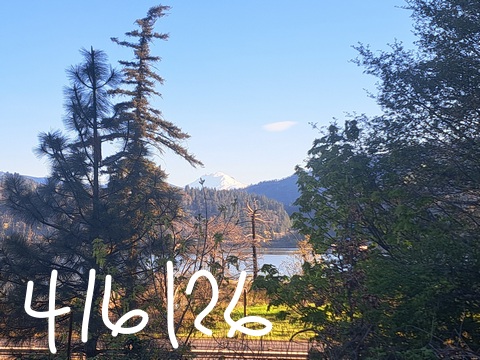
Glenwood this morning
Looking around the Gorge this morning…. Fuckin’ Glenwood dipped to 33F last night and is standing tall and proud above the crowd this morning. Middle Mountain, above the inversion, was 50F at sunrise. WARM! While we didn’t set any record low or high-low temps today, we might just set a record high today! Temps rise to the upper 70s or low 80s all across the lowlands. Hood River’s record for this date is 79 degrees, and the forecast high is 78 degrees. EEEEEEEEEEEEEE! A fuckin’ record is within reach. It’s gonna be hella hot today!
Today’s Gorge wind forecast
After a clear-as-F start (hey, F bombs are apparently appropriate to say anytime, anywhere, by ANYONE now – INVOKE THE FUCKIN’ 25TH!!!), we finish with a few high clouds and yet another colorful fuckin’ sunset. Calm wind persists through midday. Westerlies pick up to 15-20mph west of Lyle and 20-25mph from Lyle to Arlington’s fuckin’ Triangle this evening.
Tuesday’s Gorge weather forecast
As an almost-unnoticeable weather system swings through overnight into Tuesday morning, the wind picks up and a few high clouds move in. Despite cooler temps aloft (as low as 0C), we shouldn’t’ see frost thanks to the fuckin’ restless, constantly-moving air. Temps start in the 40-45 range most places and rise to 60F (west), 63F (The Dalles), and 67F (The Desert). Tuesday morning wind will be 20-25mph early west of Lyle and East of The Dalles with 15-20mph in between. Afternoon wind falls to 15-20mph between Stevenson and Rufus and drops below 15mph to the east of Rufus. Up in the hills: also fuckin’ windy.
Wednesday’s Gorge weather forecast (frost possible)
Everything calms down Tuesday night into Wednesday morning. We’re left clear and fuckin’ chilly. With 850mb (~5000′) temps at +2C, frost is a possibility above 1000′ or so. We’ll check in tomorrow about this. Afternoon sees the high temp rise to SIX-SEVEN degrees. Wind will be calm early, E 10-15mph near Stevenson midday, and W 10mph from Stevenson to Hood River or Mosier in the afternoon with light wind to the east and in the fuckin’ hills.
Extended Gorge weather forecast
Warm, light wind, sunny weather is forecast on Thursday with high temps around 70F. A couple degrees more warmth is forecast on Friday. For the weekend, we’re (likely) looking at fuckin’ cooler weather with a chance of a few sprinkles and a little mountain-fuckin’-snow. Thanks to clouds, frost looks unlikely, but we’ll check in about that as we get closer. With all this nice weather on tap, your garden is calling. Fuckin’ heed the call!. Safe travels. -TATAS
HEY! DON’T STOP READING! Is this community-focused forecast helpful to you? It sure is! It takes me a couple hours a day to write. Please join your friends and neighbors in contributing to keep it going. Venmo: @thegorgeismygym PayPal: twomirrors@gmail.com USPS: Temira / PO Box 841 / Hood River, Oregon 97031 You can test out the forecast subscription for a few days for free by signing up below. Easy! Do it!
JONES BEACH, SAUVIE ISLAND, & COAST FORECAST
ON WINTER VACATION UNLESS DESPERATELY NEEDED.

Leave a Reply