

MT HOOD SNOW FORECAST

QR codes and links for end-of-season tips – thank you!!!
Did this forecast make your snow sports season better? If so, please contribute to thank me for all the hard work that goes into this!
Cash/check: Temira – PO BOX 841 – Hood River, Oregon 97031


Hey skiers and snowboarders! Meadows is done for the season now, but Timberline is hanging in there. Uphill traffic is not yet allowed at MHM (today’s employee ski day!), but keep an eye out for the end of “no uphill traffic” season. Hopefully in time for the Wednesday-Thursday storm!
Monday starts out clear and windy on Mt. Hood and stays that way. The free air freezing level will be around 3500′ all day and will fall to 2500′ overnight. Wind will be W 40 this morning, W 25 this afternoon, and WNW 20-30 overnight. Temps hover in the 30-32F range. Snow surface: probably frozen granular.
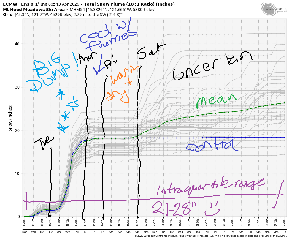
Short term Mt Hood snow forecast
Tuesday starts cloudy ahead of The Big Storm that’s coming our way. Snow kicks in mid-afternoon and intensifies overnight. The snow level will be 3500′ for most of the system and will drop to 1000-1500′ overnight. Period to 5pm, we’re expecting 0.2” water equivalent (WE), for a couple inches of snow at 5000′. Between Tuesday evening and early Wednesday, approximately 1.3” WE is expected for 11-14” new snow. Wind will be WNW 20-30 early, SW 20-35 midday, WSW 40-50 in the evening, and NW 30-35 after midnight. Yay! Snow! Temps max out in the 30-32F range before falling overnight.
Wednesday starts snowy, switches to flurries and sunbreaks midday, and turns snowy again in the afternoon. The snow level will be 1000-1500′ in the morning, 2000′ in the afternoon, and the freezing level will drop to 1000′ overnight. It’s difficult to predict snow totals due to the showery nature of this setup. Call it 2-4” during the day and 1-2” overnight. Wind will be NW 25-35 in the morning, W 35 in the afternoon, and NW 30-40 after midnight. Temps max out in the mid to upper 20s.
Extended Mt Hood Snow Forecast
A few flurries Thursday morning give way to sunny sky. The snow level will be 1000′ in the morning, 3000′ in the afternoon, and 1000-1500′ after midnight. Up to an inch of new snow is forecast in the morning. Wind: NW 30-40 in the morning, NW 25-35 in the afternoon, and WNW 20-25 after midnight. High temp at 5000′: low 30s. Cool weather continues into Friday.
Beyond that, the weekend looks warm. Starting early next week, uncertainty impedes any ability to forecast. Generally speaking the weather does look pretty dry… Have fun up there this week!
Was that helpful? I knew it was! Guess what? All of this crucial work – from your personal wind and snow reports to the invaluable TATAS updates – is made possible by my relentless efforts. Maintaining this labor of love isn’t easy. Each daily forecast takes hours. Website hosting, weather model access, and back-end admin work takes time and money. That’s where you come in.
YOUR CONTRIBUTION MAKES A DIFFERENCE
- SUPPORT ACCURATE, HYPER-LOCAL WEATHER FORECASTING
- ENABLE ACCESS FOR ALL, EVEN THOSE WITH LESS MEANS
- SUPPORT A COOL HUMAN WHO WORKS HARD SO YOU CAN PLAY
Take a moment to click one of the buttons below. Donate $19.99 or more (how much does this forecast enhance your life?) and get the email in your inbox. Whether it’s a renewing subscription (auto-renew) or a one-time donation, every contribution makes a real difference. Help me keep this labor of love alive, so we can all continue playing, commuting, and living in the Gorge with peace of mind and the best weather forecasts possible. Thank you!


Hood River, Oregon 97031


GORGE WIND FORECAST
If you’re still seeing yesterday’s and it’s after 9am, try opening this in an incognito window
SHORT-TERM gorge wind forecast
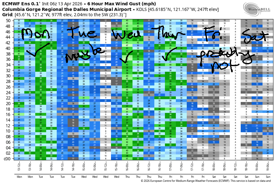
Hi friends! A windy day is on tap today, and that’s not the only west wind day in our future. Gusty westerlies continues on Tuesday with strong westerlies out east on Wednesday and another round of solid westerlies on Thursday. Wind backs off Friday and Saturday, and uncertainty skyrockets on Sunday to leave us guessing.
Today, Monday, started with pressures of 30.05/29.95/29.83 for gradients of 0.10/0.12 – this suggests wind all through the Gorge but especially east of Lyle or east of The Dalles. The day starts with up-and-down 10-20mph west of The Dalles with 24-27mph from Avery to Threemile. By late morning, we’ll have 28-32mph from Avery to Hermiston. The wind holds through late afternoon and then fades to 25-28mph or a bit less. Between Mosier and Doug’s, we have questionable wind today – it really depends on how far the clouds burn back – less clouds means more wind, and vice-versa.
RIVER FLOW FOR SITES BETWEEN AVERY (EAST OF THE DALLES) AND RUFUS: CLICK HERE FOR JOHN DAY DAM FLOW.
RIVER FLOW FOR SITES BETWEEN STEVENSON AND DOUG’S BEACH (WEST OF THE DALLES): CLICK HERE FOR THE DALLES DAM FLOW

LONGER-TERM gorge wind forecast
West of Mosier, intermittent showers are forecast all day. We can’t rule out a period of gusty 20-25mph from Viento to the Hatch until late morning, but I’m not going to rule it in either. Head east for best results. River flow over the last 24 hours was 179-227kcfs (218-222kcfs at Rufus), river temp is 50.2F, and high temp forecast is 57F for Hood River and six-seven degrees in the mostly-sunny desert.
Tuesday’s overall weather picture is dominated by an approaching strong cold front. The day starts with under 10mph west of The Dalles and gusty 13-16mph east of The Dalles. Just ahead of the front, mid-morning ish, we should see a brief burst of gusty 20-25mph from Viento to the Hatch. Once the rain starts, the wind drops to gusty 14-17mph west of The Dalles. Out east, we’ll have gusty, unreliable, up-and-down 20-26mph between Avery and Arlington. High temp: 54F with increasing rain to the west and 61F with increasing clouds out east.
Wednesday sees this system move inland. High pressure slowly builds offshore, and wind aloft will be moderately strong out of the NW. Ensembles are calling for more wind than the operational GFS – we should see somewhere in the 26-30mph range east of The Dalles. High temp: 51-56F with clouds to the west and partly cloudy sky out east.
All that movement settles down on Thursday. We’re left with a 27-30mph day between Mosier and Rufus with lighter wind in the cloudy western Gorge. Lesser westerlies, low teens (best guess) is our Friday expectation. Saturday looks similar. Far more uncertainty is present for next Sunday’s forecast, so I’m not even going to guess. Have a great day on the Nch’i Wana today!
BARE BONES HOOD RIVER WEATHER FORECAST
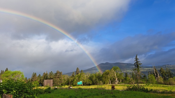
Mostly cloudy this morning with sprinkles this morning. Partly cloudy later. Temps start near 50 and rise to the upper 50s. Moderate westerlies. 100% chance of rainbows. Tuesday will be dry early then rainy. Temps start in the low 40s and rise to the mid 50s. Light to moderate westerlies. 99% chance of rainbows. Wednesday will be showery. Temps start in the upper 30s and rise to the low 50s. Light to moderate westerlies. 99% chance of rainbows.
TEMIRA’S AWESOME TRAVEL ADVISORY SERVICE
HYPERLOCAL WEATHER FORECAST FOR THE COLUMBIA GORGE
THE DALLES, HOOD RIVER, WHITE SALMON, TROUT LAKE, STEVENSON, CASCADE LOCKS, PARKDALE, ODELL, HUSUM, BZ, MILL A, WILLARD, GOLDENDALE, RUFUS, ARLINGTON, boardman
Good morning, neighbors! Wow… Ma Nature sure did under-perform in the rain department yesterday. Wraparound moisture never wrapped around, and most of us stayed dry, sunny, and breezy. Next chance of significant moisture is Tuesday afternoon into Wednesday, when a stronger system will bring heavy rain west of Mosier and heavy snow for the Cascades and passes. Frost is possible Wednesday, likely Thursday, and possible Friday. More on that in a bit…
Glenwood this morning
Up in Glenwood on this Monday morning, it’s not very Glenwood-like: 44 degrees up there to start the day. Everyone is enjoying the warmth and doing line dances in nothing but their cowboy boots. People are comfortable in their own skin in Glenwood. May we all achieve the same!
Today’s Gorge weather forecast
Today’s weather brings intermittent showers as far east as Underwood Mountain (which used to be a volcano, but is now sleeping). Clouds dissipate east of Rowena and linger to the west. This disparity results in strong west wind east of The Dalles: 25-35mph all day long as far east as Hermiston. West of The Dalles, westerlies will be 10-20mph depending on the moment of time you’re measuring them. Temps rise to 57 (west), 60 (The Dalles), and SIX-SEVEN (The Desert).
Tuesday’s Gorge weather forecast
Clouds increase tonight ahead of an incoming system. With that blanket in place on Tuesday morning, we’re unlikely to see frost despite the freezing level being at 2500′. Rain arrives from the NW late morning. By 2pm, we’ll have drizzle to Hood River. Rain slowly creeps eastward, but doesn’t do more than sprinkle east of Rowena until after midnight. West of Hood River, rain will be heavy between 2pm Tuesday and 5am Wednesday. “Heavy” means enough to fuck with your drive to/from the metro area. Tuesday morning wind will be up-and-down 10-20mph from Stevenson all the way to Hermiston. Afternoon wind rises to 20-30mph east of The Dalles. High temps: 54F to 61F.
Wednesday’s Gorge weather forecast
In the wee hours of Wednesday, this system slides to the southeast. Everyone, including south Wasco and other areas normally in the rain shadow of the Cascades, sees some rain for a few hours. After this system moves through, the snow level falls to 1000-2000′. While there won’t be much moisture around Wednesday, flurries are completely possible above 1000′. A little snow could accumulate in the evening on grass and other not-warm objects at our highest elevations. Wednesday wind will be 10-15mph west of The Dalles and 25-30mph to the east. Temps max out in the low 50s (west) to mid 50s (The Dalles and areas to the east).
Extended Gorge weather forecast
Overnight Wednesday, the sky at least partially clears. Cloud coverage is going to impact frost coverage on Thursday morning: more clouds = less frost and warmer temps. Aloft: windy. Down low: windy. This is going to mitigate some frost/freeze concerns, but not all of them: 850mb (~5000′) temps are forecast to be -5/-6C with a freezing level around 1000′-1500′. Upper Valley, Trout Lake, and anyone above 1500′ is likely to see sub-freezing temps. Rest of the day: breezy and partly cloudy. Temps max out between 54F and 59F, warmest to the east.
Friday starts cloudy to the west and clear to the east with light wind and cool temps. Again, we have a chance of frost, and again, it depends on cloud coverage. High temps: upper 50s to low 60s. Temps look warmer for the weekend. All right, that’s enough for now. Safe travels! -TATAS
HEY! DON’T STOP READING! Is this community-focused forecast helpful to you? It sure is! It takes me a couple hours a day to write. Please join your friends and neighbors in contributing to keep it going. Venmo: @thegorgeismygym PayPal: twomirrors@gmail.com USPS: Temira / PO Box 841 / Hood River, Oregon 97031 You can test out the forecast subscription for a few days for free by signing up below. Easy! Do it!
JONES BEACH, SAUVIE ISLAND, & COAST FORECAST
ON WINTER VACATION UNLESS DESPERATELY NEEDED.

Leave a Reply