

MT HOOD SNOW FORECAST

Hey skiers and snowboarders! Oh what a difference 1000′ of elevation makes! Meadows Nordic (about the same elevation as Teacup, 4300′ or so) had 2” of snow last night. Meadows base (5380′) picked up 7”. Timberline base (5800′) is reporting 13” of new via telemetry. That’s a welcome addition to a very bleak snowpack. Looking at the SWE map from yesterday (2/8), the Mt. Hood test side was at zero percentile (worst year ever) and 30% of normal. Yesterday’s snow (and the rain too) should bring today’s reading up once the calculations are in. That’s good, because this week looks dry.
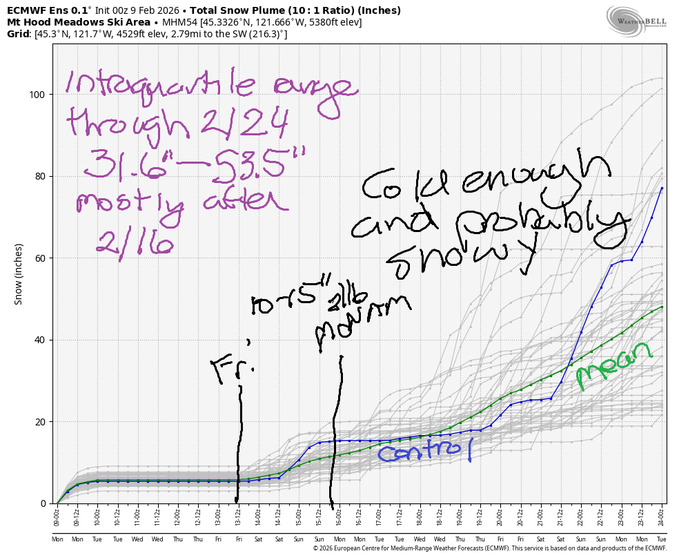
Snow returns Friday. While the longer-range forecasts aren’t certain how much snow we’ll pick up, they are insistent that temps will be cold enough for snow starting Friday and staying that way for a good, long while. The intraquartile range for snowfall between this morning and next Monday is 10-15”. The intraquartile range between now and 2/24 is 31.6”-53.5”, mostly arriving after 2/16.
Short term Mt Hood snow forecast
Looking at Monday, we’ll have snow flurries through midday followed by partly cloudy sky this afternoon and mostly clear sky tonight. The snow level will be +/- 3000′ all day today. We’re only expecting about 0.1” water equivalent (WE) today for another inch of fresh snow. Wind will be W 35 this morning, SW 10 this afternoon, and SE 20 overnight. Groomed snow surface today: packed powder up high and dense packed snow down low. Off the groom: actual fresh snow to ride!
Tuesday will be partly high overcast with filtered sun. The free air freezing level will be +/- 3000′ all day. Temps max out in the upper 20s to low 30s at 5000′.Wind will be SE 20 in the morning, E 20 in the afternoon, and E 15 overnight. Sun is forecast on Wednesday. The free air freezing level will be around 3000′ in the morning, 4000′ in the afternoon, and 4500′ overnight. Temps max out in the low-mid 30s at 5000′. Wind will be E 15 in the morning, E 10 in the afternoon, and light westerly overnight. Clear sky sticks around Thursday with temps right around freezing and increasing west wind.
Extended Mt Hood Snow Forecast
Longer-range forecast models suggest snow will return late Friday. More notably, they (generally) keep temps at 5000′ well below freezing from Friday on through at least 2/24. Those models also bring in intermittent light to moderate snowfall. This is the first clear sign the models have given of an extended period of wintry weather on the slopes. Super welcome change! Fingers crossed!
Was that helpful? I knew it was! Guess what? All of this crucial work – from your personal wind and snow reports to the invaluable TATAS updates – is made possible by my relentless efforts. Maintaining this labor of love isn’t easy. Each daily forecast takes hours. Website hosting, weather model access, and back-end admin work takes time and money. That’s where you come in.
YOUR CONTRIBUTION MAKES A DIFFERENCE
- SUPPORT ACCURATE, HYPER-LOCAL WEATHER FORECASTING
- ENABLE ACCESS FOR ALL, EVEN THOSE WITH LESS MEANS
- SUPPORT A COOL HUMAN WHO WORKS HARD SO YOU CAN PLAY
Take a moment to click one of the buttons below. Donate $19.99 or more (how much does this forecast enhance your life?) and get the email in your inbox. Whether it’s a renewing subscription (auto-renew) or a one-time donation, every contribution makes a real difference. Help me keep this labor of love alive, so we can all continue playing, commuting, and living in the Gorge with peace of mind and the best weather forecasts possible. Thank you!


Hood River, Oregon 97031


GORGE WIND FORECAST
If you’re still seeing yesterday’s and it’s after 9am, try opening this in an incognito window
SHORT-TERM gorge wind forecast
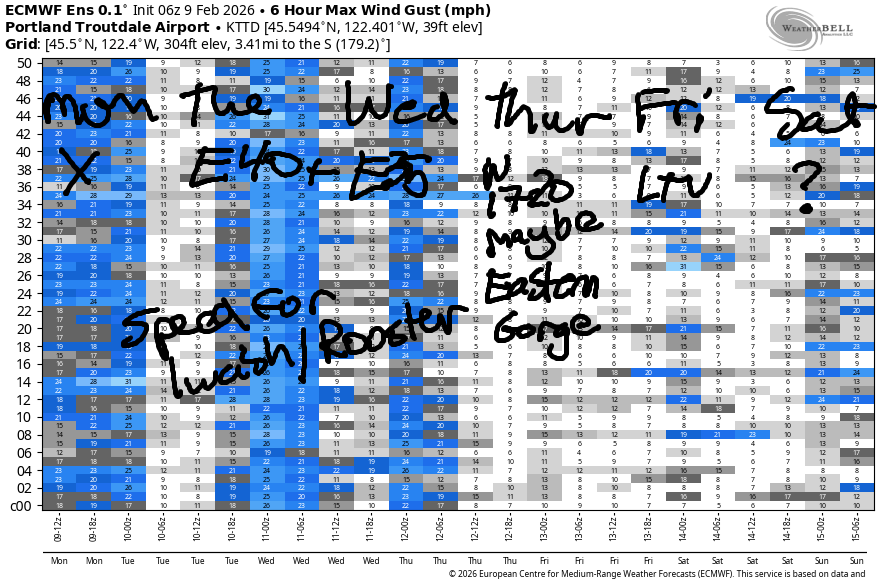
Hi friends! In the upcoming week, we have a couple days of easterlies for you. After Wednesday, there’s some chance for light westerlies as weak weather systems move through, but there’s no solid sign of any big west wind days in the next couple of weeks.
Today started with pressures of 30.33/30.28/30.25 for a small onshore gradient. East of The Dalles, speeds were in the low teens to start the day. The west side was looking mighty glassy, at least in Hood River. Models do say we’ll have light west flow all day long, but it won’t be enough to get you on the river. River flow over the last 24 hours was 129-178kcfs, river temp is 41.2F, and high temp forecast is 49F.
RIVER FLOW FOR SITES BETWEEN AVERY (EAST OF THE DALLES) AND RUFUS: CLICK HERE FOR JOHN DAY DAM FLOW.
RIVER FLOW FOR SITES BETWEEN STEVENSON AND DOUG’S BEACH (WEST OF THE DALLES): CLICK HERE FOR THE DALLES DAM FLOW

LONGER-TERM gorge wind forecast
Tuesday brings offshore wind thanks to cold air in the desert and warmer air on the west side. Add in a weak high settled off Vancouver Island, and you have both an east wind day for the Gorge and a coast wind day. Easterlies will be 45mph at Iwash in the morning and 25mph there in the afternoon. Stevenson starts with 30-35mph and fades to 25mph. East of Hood River, you’ll find easterlies at 10-15mph. With easterlies spilling over the Cascade crest, speeds could under-perform in the Gorge. Out on the coast: Side-offshore 15-20 (north), 20-25 (central), and 10-15 (south). High temp: 48F and mostly sunny in the windy zones.
Easterly flow diminishes on Wednesday, but if you’re out early, there should be enough. Iwash starts with 35-40 and fades to 15-20 in the afternoon. Stevenson starts with 25 and fades to 15-20. Out on the coast (North/Central/South) we have: 15-20/15-20/25-30. High temp: 49F and sunny.
A weak system passes through on Thursday. That might turn the wind weekly onshore. As of this morning, it does not look like we’ll see enough wind to get folks on the river; the GFS deterministic calls for 17-20mph all the way from Stevenson to Arlington, but the ensembles aren’t nearly as optimistic. High temp: 49F and high overcast. Friday’s forecast is currently for light/variable wind. Beyond that, more active (and colder/wetter) weather is forecast. That’s all for today. Stay safe out there in the chilly river!
BARE BONES HOOD RIVER WEATHER FORECAST
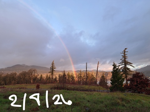
Showery this morning. Clear this afternoon. Temps start in the upper 30s and rise to the upper 40s. Light westerlies. 100% chance of rainbows. Tuesday will be Nothing then clear. Temps start in the mid 30s and rise to the upper 40s. Light to moderate easterlies. No rainbows. Wednesday will be partly Nothing then clear. Temps start in the low 30s and rise to the upper 40s. Light easterlies. No rainbows.
TEMIRA’S AWESOME TRAVEL ADVISORY SERVICE
HYPERLOCAL WEATHER FORECAST FOR THE COLUMBIA GORGE
THE DALLES, HOOD RIVER, WHITE SALMON, TROUT LAKE, STEVENSON, CASCADE LOCKS, PARKDALE, ODELL, HUSUM, BZ, MILL A, WILLARD, GOLDENDALE, RUFUS, ARLINGTON, boardman

Good morning, neighbors! Congratulations to all the Seahawks fans out there! That was a well-played game, and it was also a sweet show of camaraderie and humility by the players who were interviewed. Also much appreciated was the marquee during the (awesome) Bad Bunny halftime show that read “The only thing more powerful than hate is love.” Wise words in this time. Perhaps we can contemplate them together today and put them into action in our own small community. Caring for each other is a place to start.
Glenwood this morning
We can start today with a little love for our friends in Glenwood: 39 degrees there this morning. Also toss out some love for the snowpack and everything affected by it. 5380′ picked up 7”, and 6000′ picked up 13”. This. Is. Good.
Our long-range Gorge forecast brings showers today, dry weather with morning Nothing this week, and cooler, wetter weather starting sometime in the Friday-Saturday window. Cool, damp weather sticks around for the extended period. This is happening because I planted peas in my garden. In other words, it looks like winter is about to (finally) kick off here in the Gorge. It’s impossible to say now if we’ll see snow for some of us – too much range exists in the temp forecasts – but the overall setup does point to the possibility of snow above 1000′ or so starting a week or so from now.
Today’s Gorge weather forecast
Today (Monday), however, we’ll just see some morning sprinkles followed by a dry afternoon. West of Viento, sprinkles continue into mid-afternoon before the sky clears for all. Yay. Sun. Lowland temps rise to the upper 40s (west), low 50s (The Dalles), and mid 50s (desert). Wind will be light westerly all day.
Tuesday’s Gorge weather forecast
Calm wind overnight allows the Nothing to build near the Nch’i Wana (Big River) on Tuesday morning. Away from it, the sky starts partly high overcast with filtered starlight. This allows areas away from the Nothing to drop below freezing, especially given the fact that 850mb temps will be under 0C. In the Nothing, freezing fog and frosty roads are possible. By afternoon, we should be back to clear sky on the west side. East of The Dalles: mid and high clouds. Highs rise to the upper 40s all across the land. Those of you driving to/from the metro area will find east wind at 45mph near Iwash (schl*ng) Rock in the morning and 25mph in the afternoon. Easterlies will be widespread: elsewhere, they’ll rise to 10-15mph in the afternoon.
Extended Gorge weather forecast
On Wednesday, we start with partial Nothing and clear sky away from it. Widespread below-freezing temps and frosty roads are likely. Under the Nothing: probably 33-34F, but above it, mid-20s are possible. Sunshine (thankfully) is forecast in the afternoon with temps nearing 50F. Easterlies will be 35-40mph near Iwash in the morning and 15-20mph in the afternoon. Thursday looks similar, but the wind will be lighter. Friday starts the same and (probably) finishes wet.
Next weekend is too far into the future to be certain about the details, but models do suggested colder, intermittently damp weather with the snow level lower than it’s been this year. We’ll keep a close eye on it. In the meantime, keep your fingers crossed that the forecast is correct about the Nothing burning off each day this week! Safe travels. -TATAS
HEY! DON’T STOP READING! Is this community-focused forecast helpful to you? It sure is! It takes me a couple hours a day to write. Please join your friends and neighbors in contributing to keep it going. Venmo: @thegorgeismygym PayPal: twomirrors@gmail.com USPS: Temira / PO Box 841 / Hood River, Oregon 97031 You can test out the forecast subscription for a few days for free by signing up below. Easy! Do it!
JONES BEACH, SAUVIE ISLAND, & COAST FORECAST
ON WINTER VACATION UNLESS DESPERATELY NEEDED.
