

MT HOOD SNOW FORECAST

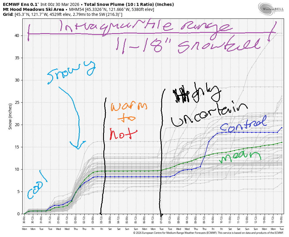
Hey skiers and snowboarders! At least it’s chilly on the mountain this morning! Chilly weather sticks around through Thursday, and there’s even a solid snowstorm in the forecast! Starting Friday, we’re back to warm weather for a few days. Uncertainty skyrockets Monday and leaves all of us guessing. The intraquartile range for snowfall through April 14th is 11-18”.
Short term Mt Hood snow forecast
Monday started with a few high clouds, but sun is on the way. The free air freezing level (FAF) climbs from 1000′ this morning to 3000′ this afternoon and falls back below 3000′ overnight. Temps today max out in the 32-35F range at 5000′. Wind will be NE 10 this morning, E 10-15 this afternoon, and E 10 overnight. Expect frozen granular surface conditions that soften to corn snow in the sun.
Tuesday will be sunny to start, cloudy in the afternoon, and snowy after midnight. The snow level will be 2000′ in the morning, 4000′ when the snow arrives, and 2000-2500′ after midnight. Just an inch or so of new snow is forecast overnight. You’ll have to wait for Wednesday for more! Wind will be E 10 in the morning, WSW 10-15 in the afternoon, and SW 15-30 overnight.
Extended Mt Hood Snow Forecast
On Wednesday, it will be snowy! The snow level starts around 2500′, rises to 4500 mid-morning’, falls to 3500′ in the afternoon, and drops to 2000′ or less overnight. About 0.9” water equivalent (WE) is forecast during the day for 7-10” new snow. Snow! Yay! Overnight, another 0.3” WE is forecast for 2-4” more. Wind will be SW 15-30 during the day, W 30 in the evening, and WNW 25-30 after midnight.
Lingering flurries Thursday morning give way to sunshine in the afternoon. The snow level will be 2000′ or less early, 2500′ in the afternoon, and 1500′ after midnight. Wind starts at WNW 25-30, turns to W 25, and becomes NW 20-25 after midnight.
Sunny, warming weather is forecast on Friday. Dry, warm weather continues through the weekend. Uncertainty increases late Sunday into Monday. With that much uncertainty, I’m not even going to guess. We’ll look at it again tomorrow. Have fun on the snow today!
Was that helpful? I knew it was! Guess what? All of this crucial work – from your personal wind and snow reports to the invaluable TATAS updates – is made possible by my relentless efforts. Maintaining this labor of love isn’t easy. Each daily forecast takes hours. Website hosting, weather model access, and back-end admin work takes time and money. That’s where you come in.
YOUR CONTRIBUTION MAKES A DIFFERENCE
- SUPPORT ACCURATE, HYPER-LOCAL WEATHER FORECASTING
- ENABLE ACCESS FOR ALL, EVEN THOSE WITH LESS MEANS
- SUPPORT A COOL HUMAN WHO WORKS HARD SO YOU CAN PLAY
Take a moment to click one of the buttons below. Donate $19.99 or more (how much does this forecast enhance your life?) and get the email in your inbox. Whether it’s a renewing subscription (auto-renew) or a one-time donation, every contribution makes a real difference. Help me keep this labor of love alive, so we can all continue playing, commuting, and living in the Gorge with peace of mind and the best weather forecasts possible. Thank you!


Hood River, Oregon 97031


GORGE WIND FORECAST
If you’re still seeing yesterday’s and it’s after 9am, try opening this in an incognito window
SHORT-TERM gorge wind forecast
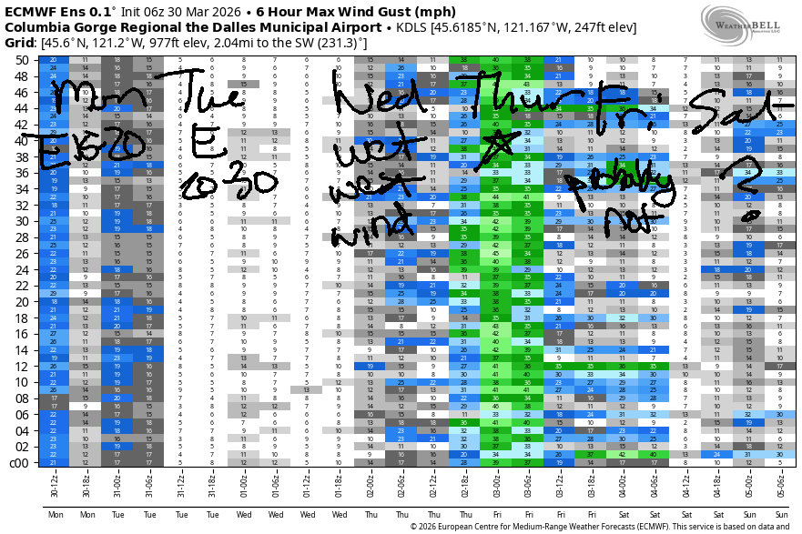
Hi friends! Not much happens between Monday and Wednesday, but a decent day of eastern Gorge westerlies is looking more and more likely for Thursday. Calm wind returns on Friday, so that Thursday blow is a one-day extravaganza for you.
Monday kicks off with light west wind, but that won’t last. Easterlies pick up to 15-20mph this afternoon at both Iwash (Rooster) Rock and Stevenson. Near Hood River, easterlies rise to 5-10mph. River flow over the last 24 hours was 222-252kcfs, river temp is 47.1F, and high temp forecast is 55F with sunshine.
RIVER FLOW FOR SITES BETWEEN AVERY (EAST OF THE DALLES) AND RUFUS: CLICK HERE FOR JOHN DAY DAM FLOW.
RIVER FLOW FOR SITES BETWEEN STEVENSON AND DOUG’S BEACH (WEST OF THE DALLES): CLICK HERE FOR THE DALLES DAM FLOW

LONGER-TERM gorge wind forecast
Tuesday starts with E 25-30mph at Iwash and E 20-25mph at Stevenson. Stevenson holds for a few hours. Iwash quickly drops to 15-20mph. By mid-afternoon, Iwash turns light westerly, and Stevenson becomes light and variable. High temp: 54F and mostly cloudy.
Wednesday looks wet. Thanks to an offshore low, the wind starts at E 20mph or so at both Stevenson and Iwash. Midday wind will be calm. As the system pushes eastward mid-afternoon, there will be a brief bump in the wind. You’ll find very gusty, up-and-down, 20-30mph for 30-90 minutes as the low moves inland. Best opportunities will be east of The Dalles. High temp: 50F with lots of rain.
Another low moves inland early Thursday, and high pressure builds offshore. With clouds on the west side, you’ll find the strongest, steadiest wind to the east of Hood River. For now, let’s call it 29-33mph from Mosier to Threemile, but it may end up being Lyle to Threemile. High temp: 52F in Hood River and 58F in the desert.
Uncertainty increases after Friday (calm wind Friday, if you were wondering). The GFS deterministic offers up solid westerlies for the weekend, but there’s no agreement in the ensembles… yet… I’ll have my fingers crossed! See you on the Nch’i Wana soon!

BARE BONES HOOD RIVER WEATHER FORECAST
Partly high overcast this morning. Clear later. Temps start in the upper 30s and rise to the mid 50s. Calm wind then light easterlies. No rainbows. Tuesday will be mostly cloudy. Temps start in the mid 30s and rise to the mid 50s. Light easterlies. No rainbows. Wednesday will be rainy. Temps start in the upper 30s and rise to 50 or so. Light easterlies then calm wind. 11% chance of rainbows.
TEMIRA’S AWESOME TRAVEL ADVISORY SERVICE
HYPERLOCAL WEATHER FORECAST FOR THE COLUMBIA GORGE
THE DALLES, HOOD RIVER, WHITE SALMON, TROUT LAKE, STEVENSON, CASCADE LOCKS, PARKDALE, ODELL, HUSUM, BZ, MILL A, WILLARD, GOLDENDALE, RUFUS, ARLINGTON, boardman

Good morning, neighbors! I woke up quite late this morning, but I woke up early enough to see that clouds stuck around long enough last night to protect us from sub-freezing temps most places. Upcoming this week: cool temps and a very wet Wednesday. Warmer weather returns on Friday and sticks around for the weekend.
Glenwood this morning
Up in Glenwood this morning (it’s Monday, apparently, even in Glenwood), it was 28 degrees. Elsewhere: the Parkdale area was hovering right around freezing as was Trout Lake. Next chance for frost is Wednesday morning when the comb of clear sky and light east wind and low dewpoints (low 20s to the south, teens to the north) allow radiational cooling to work its magic.
Today’s Gorge weather forecast
Monday’s weather becomes increasingly sunny as the sky rids itself of pesky clouds. Calm wind early gives way to easterlies: 20mph at Iwash (cock) Rock and Stevenson; 5-10mph along the Nch’i Wana lowlands; 10mph in the hills. High temps rise to the mid 50s (west), upper 50s (The Dalles), and mid 50s (The Desert).
Tuesday’s Gorge weather forecast
Revisiting the models for Tuesday morning, we have disagreement about cloud cover. How annoying! Models keep us clear until 1am or so, when they drag clouds in. This is going to be really close for frost on the south side of the Nch’i Wana – to the north, it’ll almost certainly be clear and quite chilly. Rest of Tuesday: increasing clouds and temps rising to 54-57F in the lowlands. Wind will be E 25mph near Stevenson and Iwash (male member) Rock in the morning with light/variable wind all through the Gorge in the afternoon.
Wednesday’s (wet) weather forecast
Rain arrives in the wee hours of Wednesday. Commuters: you’ll find heavy rain west of Hood River from 5am Wednesday through 5am Thursday. Yucky driving, for sure. Moderate rain extends all the way to Celilo Village by 8am and makes it all the way to the Tri-Cities by 2pm. Morning temps will be in the upper 30s. Afternoon: 50F to the west and 55F from The Dalles eastward. Wind will be E 20mph in the usual spots in the morning and calm midday. Evening brings light westerlies west of The Dalles and westerlies at 20-30mph to the east.
Extended Gorge weather forecast
Overnight, rain tapers off. A few showers linger into Thursday morning. By afternoon, we’ll have clouds west of Mosier and sun to the east with strong to very strong west wind from Mosier east into the desert. High temps: 52-58F. Friday looks calm, sunny, and warmer. How nice! Warm weather continues into the weekend. Okie dokie. It’s already 9am, and I’d better get this forecast posted so we can all get on with our days. Safe travels. -TATAS
HEY! DON’T STOP READING! Is this community-focused forecast helpful to you? It sure is! It takes me a couple hours a day to write. Please join your friends and neighbors in contributing to keep it going. Venmo: @thegorgeismygym PayPal: twomirrors@gmail.com USPS: Temira / PO Box 841 / Hood River, Oregon 97031 You can test out the forecast subscription for a few days for free by signing up below. Easy! Do it!
JONES BEACH, SAUVIE ISLAND, & COAST FORECAST
ON WINTER VACATION UNLESS DESPERATELY NEEDED.

Leave a Reply