

MT HOOD SNOW FORECAST

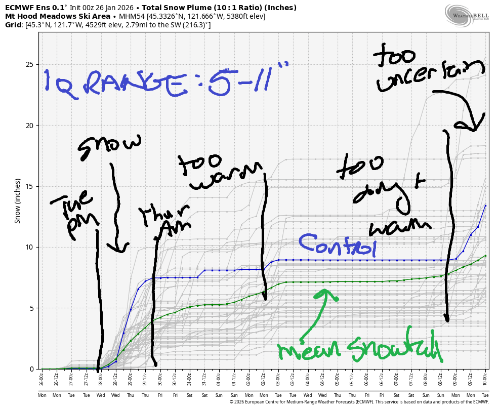
Hey skiers and snowboarders! It’s Monday, and it’s another dry day on Mt. Hood. This long dry spell comes to an end on Tuesday afternoon. We’ll pick up some snow Tuesday night into Thursday morning, after which temps warm again. A lot of uncertainty remains in the details of the incoming precipitation. The ECMWF brings in 0.9” to 2.0” water equivalent this week, and the intraquartile range for snowfall is 5” to 11”. As you might have surmised, it’s likely we’ll see at least some rain in this time period after the snow falls. Fingers crossed it’s minimal! After Thursday, the weather is likely to turn warm and dry again, although we may see some rain Saturday and also early next week.
Short term Mt Hood snow forecast
Monday starts partly high overcast with temps in the 22F to 38F range depending on elevation. At 5000′, the day started warm – upper 30s. The free air freezing level will be around 6000′ all day under partly cloudy sky. Wind will be SW 15-20 in the morning, SW 15-25 in the afternoon, and S 10-15 overnight.
Tuesday starts high overcast. Clouds build during he day, and light snowfall arrives around 4pm. The snow level will be 6000′ in the morning and will fall to around 4000′ in the evening. Temps at 5000′ drop to right around 32F, just cold enough for snow. About 0.1” to 0.2” water equivalent (WE) is forecast overnight for 1-2” of snow. Some ensemble members bring more. Vote for them. Wind will be S 10-15 in the morning, S 10-20 in the afternoon, SW 20-40 in the evening, and WSW 30-35 after midnight.
Extended Mt Hood Snow Forecast
Snow continues on and off all day Wednesday. The snow level will be around 4000′ all day with temps at 5000′ right around freezing. About 0.3” WE is forecast during the day for 2-3” dense snow at 5000′. Another 0.2” WE is forecast overnight for up to 2” additional dense snow. Wind will be WSW 30-35 in the morning, SW 15-30 in the afternoon, and W 20 after midnight.
Thursday starts with snow and switches to rain as the snow level rises from 4000′ to 7000′ in the afternoon and 10,000′ overnight. About 0.2” WE is forecast. Call it half snow (for an inch or so) and half rain. Wind will be W 20 in the morning, WSW 20-30 during the day, and SW 15-25 overnight. Friday looks dry and warm. We could see another round of light rain on Saturday, but that’s really too far out to predict. Generally speaking, temps at 5000′ look too warm for snow for the extended period, but it also doesn’t look like we’ll see heavy rain. Could be worse…. Get up there and enjoy the conditions over the next few day! I’ll see you on the snow!
Was that helpful? I knew it was! Guess what? All of this crucial work – from your personal wind and snow reports to the invaluable TATAS updates – is made possible by my relentless efforts. Maintaining this labor of love isn’t easy. Each daily forecast takes hours. Website hosting, weather model access, and back-end admin work takes time and money. That’s where you come in.
YOUR CONTRIBUTION MAKES A DIFFERENCE
- SUPPORT ACCURATE, HYPER-LOCAL WEATHER FORECASTING
- ENABLE ACCESS FOR ALL, EVEN THOSE WITH LESS MEANS
- SUPPORT A COOL HUMAN WHO WORKS HARD SO YOU CAN PLAY
Take a moment to click one of the buttons below. Donate $19.99 or more (how much does this forecast enhance your life?) and get the email in your inbox. Whether it’s a renewing subscription (auto-renew) or a one-time donation, every contribution makes a real difference. Help me keep this labor of love alive, so we can all continue playing, commuting, and living in the Gorge with peace of mind and the best weather forecasts possible. Thank you!


Hood River, Oregon 97031


GORGE WIND FORECAST
If you’re still seeing yesterday’s and it’s after 9am, try opening this in an incognito window
SHORT-TERM gorge wind forecast
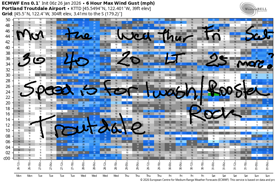
Hi friends! The east wind pattern sticks around for the extended time period. Strongest days out of the next five will be today (Monday) and tomorrow (Tuesday). Monday started with pressures of 30.23/30.32/30.33 with easterlies at 33mph at Iwash (Rooster) Rock, 20mph at Stevenson, and 19mph at Viento. The wind holds at 20mph at Stevenson and fades to 15-20mph at Iwash. River flow over the last 24 hours was 185-213kcfs, river temp is 41.4F, and high temp forecast is 42F.
RIVER FLOW FOR SITES BETWEEN AVERY (EAST OF THE DALLES) AND RUFUS: CLICK HERE FOR JOHN DAY DAM FLOW.
RIVER FLOW FOR SITES BETWEEN STEVENSON AND DOUG’S BEACH (WEST OF THE DALLES): CLICK HERE FOR THE DALLES DAM FLOW

LONGER-TERM gorge wind forecast
Tuesday starts with 30mph at Stevenson and 40mph at Iwash. Iwash holds all day. Stevenson bumps up to 35mph for a few hours mid-morning before fading to 30mph in the afternoon. High temp: 39F with high clouds all day.
Wednesday starts with easterlies at 20mph at Stevenson and 15mph at Iwash. They both finish up at 15mph. In a fun twist, it’ll be drizzling pretty much all day and into the evening. High temp: 45F under cloudy sky. Lighter east wind is forecast on Thursday. Models hint at stronger easterlies on Friday. No sign of west wind in the next couple of weeks. If you’re going out, dress warmly, have an emergency plan, and keep an eye on your buddies!
BARE BONES HOOD RIVER WEATHER FORECAST
Mostly cloudy sky all day. Temps start in the upper 20s and rise to the low 40s. Light easterlies. No rainbows. Tuesday will be high overcast all day with light rain in the evening. Temps start in the upper 20s and rise to the upper 30s. Light easterlies. No rainbows. Wednesday will be drizzly all day and into the evening. Temps start in the low 30s and rise to the mid 40s, which I guess means we could see a little icing in select spots. Light easterlies. 18% chance of rainbows.
TEMIRA’S AWESOME TRAVEL ADVISORY SERVICE
HYPERLOCAL WEATHER FORECAST FOR THE COLUMBIA GORGE
THE DALLES, HOOD RIVER, WHITE SALMON, TROUT LAKE, STEVENSON, CASCADE LOCKS, PARKDALE, ODELL, HUSUM, BZ, MILL A, WILLARD, GOLDENDALE, RUFUS, ARLINGTON, boardman
Good morning, neighbors! It’s a quiet (no ¡CE) morning in the Gorge with chilly temps thanks to partly cloudy sky last night. Enjoy whatever sun you see today – our long dry spell is coming to an end (for some of us, anyway) Tuesday evening. That said… after a few days of unremarkable drizzle, we’ll be back into dry weather for much of the next two weeks. We do have a slight chance of a little freezing rain on Wednesday morning. Other than that – nothing to be concerned about other than a developing drought…
Glenwood this morning
Checking in with our regulars this morning… Glenwood was 18 degrees at sunrise and celebrating its adulthood (18F = grown up) by reflecting on what it means to be an adult. On some level, this means having values and living by them. It also means unflinchingly looking at your values to see if they cause harm to you and others and considering changing those values if they’re tainted by hate and greed. If your values have the smell of an unwashed taint, there’s something to learn there! It takes courage to revisit what you believe, so be gentle with yourself.
Today’s Gorge weather forecast
Other chilly spots this morning: ALL OF US! Low 20s for the Upper Valley, low 20s near Dufur, low 20s in The Dalles… you get the picture. To find temps closer to 32F, you have to head to the windy zones west of Viento, where the stirred-up air is slightly warmer. By afternoon, lowland temps rise to 40sih. East wind fades from 30mph near Iwash (RELEASE THE FILES – WE HAVEN’T FORGOTTEN) Rock to 15-20mph this afternoon. Same for wind-battered Stevenson and Cascade Locks – have some compassion for them, okay? Sky coverage today: increasingly cloudy in the west, and increasingly clear to the east.
Tuesday’s Gorge weather forecast
Tuesday starts off with a partial Nothing near the Nch’i Wana (Big River) and high clouds away from it. This gives us morning temps in the mid to upper 20s. Glenwood: colder, of course! High clouds stick around all day, and temps rise to nearly 40F. Easterlies will be 40mph near Iwash (Venezuela is NOT an American colony) Rock and 30mph near Stevenson. Around 4pm, drizzly arrives. Yes, actual rain is actually forecast. It extends to The Dalles and perhaps south Wasco County in the evening and continues west of Rowena overnight. A couple things to mention: 1) the air is pretty dry, so we’re likely to see less precip than expected; 2) evaporative and radiational cooling overnight could drop temps low enough for a little freezing rain into Wednesday morning. We’ll revisit this tomorrow.
Extended Gorge weather forecast
The sounding model for Wednesday morning suggests scattered areas of light freezing rain. Let’s look more closely tomorrow morning, okay? Temps will be marginal… We will have drizzle most of the day. We’ll even see drizzle as far east as Biggs for a few hours early morning. For a few hours early in the day, just as you’re driving/from the metro area, you’ll be navigating moderately intense rainfall, puddles, and a minor risk of hydroplaning (in direct proportion to your speed). Temps Wednesday max out in the low 40s. East wind holds at 15-20mph at Stevenson and Iwash (immigration actions must follow the Constitution too) Rock. Drizzle continues Wednesday night into Thursday morning when models suggest the rain might actually make it all the way east into the desert. Tumbleweeds will be unhappy – when they are wet, they can’t tumble as far.
Friday: dry. Saturday: probably a bit of drizzle. Sunday: probably dry. Models hint at a little rain early next week. After that: probably dry and probably warm and probably sunny. That’s probably all I have to say for today. Safe travels. -TATAS
HEY! DON’T STOP READING! Is this community-focused forecast helpful to you? It sure is! It takes me a couple hours a day to write. Please join your friends and neighbors in contributing to keep it going. Venmo: @thegorgeismygym PayPal: twomirrors@gmail.com USPS: Temira / PO Box 841 / Hood River, Oregon 97031 You can test out the forecast subscription for a few days for free by signing up below. Easy! Do it!
JONES BEACH, SAUVIE ISLAND, & COAST FORECAST
ON WINTER VACATION UNLESS DESPERATELY NEEDED.
