

MT HOOD SNOW FORECAST

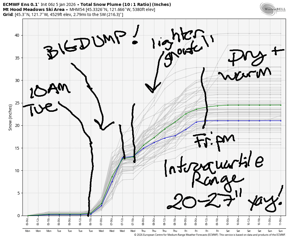
Hey skiers and snowboarders! Finally some awesome news in the forecast. Starting Tuesday afternoon, we’re heading into a period of heavy snowfall. That’s followed by cool temps and moderate snowfall much of the time through Friday. Beyond that, warm and sunny weather returns to the slopes, but we should have 20-27” of new snow on the ground by then. That range, btw, is the intraquartile range – 25th percentile to 75th percentile. Sounds awesome, right???
Short term Mt Hood snow forecast
Monday will be sunny on Mt Hood. Clouds return tonight. The free air freezing level (FAF) will be around 2000′ all day and will drop to 500-1000′ overnight. Temps at 5000′ will be in the upper 20s today. Wind: WSW 15-20mph this morning, W 10 this afternoon, and WSW 25-30 overnight.
A dry, high overcast start to Tuesday gives way to light snowfall mid-morning. By afternoon, it’ll be DUMPING! The snow level starts around 1000′, rises to 2500′ in the afternoon, and drops to 1500′ overnight with the arrival of colder air aloft. We’re expecting about 0.3” water equivalent (WE) during the day for 3-4” relatively dry new snow. Overnight, models now call for 1.2” WE for 12-14” of increasingly dry powder. Wind will be WSW 25-30 early, SW 20-40 midday, WSW 45-55 in the afternoon, and W 20-25 overnight. YES!
Extended Mt Hood Snow Forecast
Moderate snowfall continues on Wednesday with a short break around sunrise. The snow level will be 1500′ in the morning and 1000′ in the afternoon with the free air freezing level dropping to 0-1000′ overnight. About 0.4” WE is forecast during the day for 4-5” powder. Another 0.4” WE falls overnight for 4-5” additional light, fluffy snow. Wind will be W 20-25 early, SW 20-35 mid-morning, W 25 in the afternoon, and WNW 25-30 after midnight. That WNW wind could give us a couple inches more snow than expected.
Intermittent orographic flurries are in the cards Thursday daytime for 1-3” additional snow. Overnight, 0.2” to 0.3” WE arrives for 2-4” more. The snow level will be less than 1000′ in the morning, 1500′ in the afternoon, and 2000′ overnight. Expect stormy conditions: wind will be WNW 25-30 in the morning, W 40 it eh afternoon, and W 25 overnight. That’s not enough to take out the standard slate of lifts, but it is enough to warrant an extra layer of clothing. Friday: cool with another round of light snow.
Rapidly warming weather is forecast on Saturday under sunny sky. Most ensemble members hold us in warm, dry, sunny weather for quite a while. Forecast uncertainty sky rockets starting around the 15th of January, so let’s just call it warm and dry until then and revisit the extended forecast when models have more sense of what’s next. It’s worth mentioning that the big snowfall this week should be enough to carry us through this upcoming warm/dry spell. Whew. See you on the snow soon!
Was that helpful? I knew it was! Guess what? All of this crucial work – from your personal wind and snow reports to the invaluable TATAS updates – is made possible by my relentless efforts. Maintaining this labor of love isn’t easy. Each daily forecast takes hours. Website hosting, weather model access, and back-end admin work takes time and money. That’s where you come in.
YOUR CONTRIBUTION MAKES A DIFFERENCE
- SUPPORT ACCURATE, HYPER-LOCAL WEATHER FORECASTING
- ENABLE ACCESS FOR ALL, EVEN THOSE WITH LESS MEANS
- SUPPORT A COOL HUMAN WHO WORKS HARD SO YOU CAN PLAY
Take a moment to click one of the buttons below. Donate $19.99 or more (how much does this forecast enhance your life?) and get the email in your inbox. Whether it’s a renewing subscription (auto-renew) or a one-time donation, every contribution makes a real difference. Help me keep this labor of love alive, so we can all continue playing, commuting, and living in the Gorge with peace of mind and the best weather forecasts possible. Thank you!


Hood River, Oregon 97031


GORGE WIND FORECAST
If you’re still seeing yesterday’s and it’s after 9am, try opening this in an incognito window
SHORT-TERM gorge wind forecast
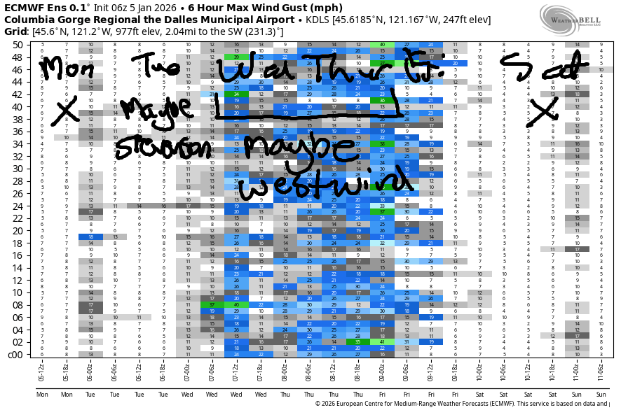
Hi friends! Light to moderate west wind is in the cards for the next three days. There’s a chance for somewhat stronger, but not nuking, westerlies on Thursday thanks to some assistance from wind aloft. Looking at Monday morning, we have pressures of 29.74/29.72/29.76 and light/variable wind. By afternoon, westerlies rise to 11-14mph from Stevenson to Hermiston. River flow over the last 24 hours was 180-204kcfs, river temp is 43.5F, and high temp forecast is 46F with sunshine.
Tuesday starts with light west wind. Mid-morning sees the westerlies pick up west of the Hatch and near Arlington. We’ll see gusty 20-25mph from Multnomah Falls to Viento and at Arlington for a few hours. High temp: 44F and rainy west of Rowena all day.
RIVER FLOW FOR SITES BETWEEN AVERY (EAST OF THE DALLES) AND RUFUS: CLICK HERE FOR JOHN DAY DAM FLOW.
RIVER FLOW FOR SITES BETWEEN STEVENSON AND DOUG’S BEACH (WEST OF THE DALLES): CLICK HERE FOR THE DALLES DAM FLOW

LONGER-TERM gorge wind forecast
Wednesday brings a slightly better chance of just-enough west wind. The day starts with 11-14mph from Stevenson to Hermiston. For a few hours in the morning, we’ll have gusty 18-22mph from Multnomah Falls to the Hatch, lighter wind from Hood River to Doug’s, and gusty 18-22mph from Avery to Arlington. The wind out east will start a couple hours later than the western Gorge wind and also last a couple hours later. By afternoon, areas west of The Dalles drop below the 11-14mph range. High temp: 44F with lots of rain.
After that Wednesday systems moves through, we’re left with a more westerly flow aloft. Models hint at the possibility of west 21-24mph all through the Gorge. That’s your best chance this week to get on the river. Friday through Sunday are likely to be calm, or at least quite light, thanks to a building ridge of high pressure. By Monday, we should have strong easterlies in response to this setup. It’s worth noting that these easterlies will be somewhat warmer than our usual winter east wind, and could be enticing for many. By “many”, I mean maybe even me! Hope to see you on the Nch’i Wana soon!
BARE BONES HOOD RIVER WEATHER FORECAST
Mostly cloudy sky this morning. Mostly clear later. Temps star tint he mid 30s and rise to the mid 40s. Light to moderate westerlies. 1% chance of rainbows. “Tuesday will be cloudy with rain from 10am on. Temp start in the low-mid 30s and finish in the mid 40s. Light westerlies. 8% chance of rainbows . Wednesday will be drizzly early then rainy in the afternoon. Temps start in the mid 30s and rise to the mid 40s. Light to moderate westerlies. 93% chance of rainbows.
TEMIRA’S AWESOME TRAVEL ADVISORY SERVICE
HYPERLOCAL WEATHER FORECAST FOR THE COLUMBIA GORGE
THE DALLES, HOOD RIVER, WHITE SALMON, TROUT LAKE, STEVENSON, CASCADE LOCKS, PARKDALE, ODELL, HUSUM, BZ, MILL A, WILLARD, GOLDENDALE, RUFUS, ARLINGTON, boardman

Good morning, neighbors! It’s a Nothing start to the day along the Nch’i Wana, and the clear sky from earlier has disappeared. Alas. But it should be back later today when the forecast calls for clear sky. By tomorrow (Tuesday) afternoon, we’ll be back to wet and/or snowy for a good portion of the time through Friday morning. Beyond that: dry for quite a while…
Glenwood this morning
Checking in with Glenwood this morning, we see 31 degrees air temp and one degree of separation. That’s what happens in small towns – everyone knows everyone. Beating Glenwood this morning: Trout Lake with 28 degrees, Dufur with 30, and a tie with Parkdale at 31. Roads do not appear to be ¡CE-y this morning, but do watch out for black ice this morning in areas that were exposed to clear sky last night. Radiational cooling is powerful, as powerful as peaceful protest in the face of tyranny, violations of international norms, and the widespread acceptance of hate and cruelty.
“Darkness cannot drive out darkness; only light can do that. Hate cannot drive out hate; only love can do that.” (MLK)
Today’s Gorge weather forecast
Keep that in your heart today as the power of the sun eventually burns away the Nothing cloud. We’ll be left with temps in the mid-40s along the river. West wind rises to 10-15mph between Stevenson and Hermiston this afternoon. Freezing level: 2000′.
Tuesday’s Gorge weather forecast
Overnight, clear sky will linger long enough for temps to drop below freezing in many areas. Precip arrives around 10am Tuesday and initially falls as snow above 1000′. Afternoon sees the snow level rise to 2500′, but it drops to 1500′ again overnight. In addition, intense precipitation will drive temps down (evaporative cooling for the win) and allow snow to fall as lower-than-expected elevations.
Areas expected to pick up significant snow on Tuesday night: Trout Lake, Willard, Mill A, Snowden, High Prairie, Glenwood, Parkdale, Appleton, Underwood, and elevated areas of Mosier, Odell, and Stevenson. With light west wind lingering, lower-elevation areas are unlikely to see snow. Wind will be 20-25mph Tuesday afternoon west of Viento and also near Arlington and in South Wasco, Gilliam, and Sherman counties as well as near Goldendale. High temps: mid to upper 40s in the lowlands.
Extended Gorge weather forecast
A brief break on Wednesday morning gives way to another round of “weather” late morning or early afternoon. Temps at 850mb (~5000) are forecast to be -5C, which is cold enough for a snow level of 1000-1500′. The snow level holds through Thursday afternoon. For most of this period, precip will stay west of The Dalles, but there’s a period Wednesday afternoon when Goldendale, Centerville, Wahkiakas and other associated areas may also see snow. Wednesday’s lowland temps: mid 30s to start and mid 40s to finish. Wind: west 10-15mph in the morning with 20mph mid-morning west of Hood River and 20mph in the afternoon east of The Dalles.
As I implied in the last paragraph, another round of light precip (rain down low, snow up high) arrive sin the Thursday-Friday time period. After that, ridging takes over. If the ensembles are correct, we’ll be high and dry for a week. Thanks to cool (not cold) air in the desert and east wind and a heat low in the Valley of Willies, we’ll stay cool for the period of the inversion, which is likely to be all next week. Beyond that? Too much uncertainty to say. Safe travels. -TATAS
HEY! DON’T STOP READING! Is this community-focused forecast helpful to you? It sure is! It takes me a couple hours a day to write. Please join your friends and neighbors in contributing to keep it going. Venmo: @thegorgeismygym PayPal: twomirrors@gmail.com USPS: Temira / PO Box 841 / Hood River, Oregon 97031 You can test out the forecast subscription for a few days for free by signing up below. Easy! Do it!
JONES BEACH, SAUVIE ISLAND, & COAST FORECAST
ON WINTER VACATION UNLESS DESPERATELY NEEDED.
