

MT HOOD SNOW FORECAST

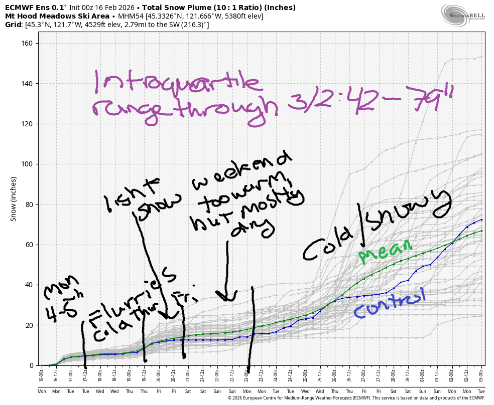
Hey skiers and snowboarders! I slept in so late today, so here we are with a late forecast! It’s a mostly good one – other than a period of warm weather (that actually doesn’t look too wet) next weekend, we have a long and fruitful and snowy relationship with Ma Nature in the future. For this week, we have cold weather coming along with intermittent light snowfall. Models give us 1-2” moisture through next weekend and then really ramp up the snowfall for the following week. Why is it always “the following week” this year? I don’t know the answer to that, but at least it’ll be cold this week!
Short term Mt Hood snow forecast
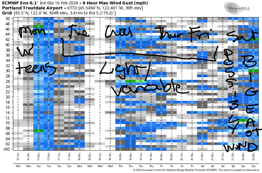
Looking at Monday, we have the snow level around 2000-2500′ to start the day. IT holds there all day, and then falls with the next system this evening. That takes the snow level below 1000′, but there won’t be much moisture left. During the day, we’re expecting about 0.4” water equivalent (WE) for about 4-5” increasingly dry snow. Snow quality is Cascade Concrete below 5000′ this morning, but it will transition to powder this evening. Nordic: red wax and a plastic bag over your outfit. Wind today: SW 5-10 this morning, WSW 15-20 this afternoon, WSW 25-350 tonight as the cold front swings through, and SW 15-25 after midnight.
Flurries are forecast Tuesday morning and Tuesday afternoon with the potential for partly cloudy sky midday and after midnight. The snow level will be around 1000′ all day, and it’ll fall to 0′ overnight. Just 0.1” WE is forecast for the 24 hours period, so an inch of snow. Wind on Tuesday: SW 15-25 in the morning, W 10 in the afternoon, and NW 15-20 overnight.
Extended Mt Hood Snow Forecast
Wednesday will be partly cloudy during the day. Light snow returns overnight. The snow level will be0′ early, 1500′ in the afternoon, and 0′ after midnight. Up to 0.2” WE is forecast overnight for up to two inches of new, which may fall in the lowlands as well! Wind: NW 15-20 in the morning, W 15 in the afternoon, and SW 10-15 overnight. Light snow continues on Thursday with the snow level at 0′.
Models suggest the weather might warm up but probably stay (mostly) dry over the weekend before snow returns late in the weekend or early next week. We’ll sort out the details as we get closer. All-in-all, things look good in the forecast: the intraquartile range through March 2nd is 42-79” of snow!
Was that helpful? I knew it was! Guess what? All of this crucial work – from your personal wind and snow reports to the invaluable TATAS updates – is made possible by my relentless efforts. Maintaining this labor of love isn’t easy. Each daily forecast takes hours. Website hosting, weather model access, and back-end admin work takes time and money. That’s where you come in.
YOUR CONTRIBUTION MAKES A DIFFERENCE
- SUPPORT ACCURATE, HYPER-LOCAL WEATHER FORECASTING
- ENABLE ACCESS FOR ALL, EVEN THOSE WITH LESS MEANS
- SUPPORT A COOL HUMAN WHO WORKS HARD SO YOU CAN PLAY
Take a moment to click one of the buttons below. Donate $19.99 or more (how much does this forecast enhance your life?) and get the email in your inbox. Whether it’s a renewing subscription (auto-renew) or a one-time donation, every contribution makes a real difference. Help me keep this labor of love alive, so we can all continue playing, commuting, and living in the Gorge with peace of mind and the best weather forecasts possible. Thank you!


Hood River, Oregon 97031


GORGE WIND FORECAST
If you’re still seeing yesterday’s and it’s after 9am, try opening this in an incognito window
SHORT-TERM gorge wind forecast
Hi friends! Not much happening this week, and along with the not much that’s happening, temps will be colder. Monday starts with pressures of 29.60/29.53/29.52 for light onshore gradients and west wind under 10mph to start the day. Around 10am, as a system swings through, westerlies pick up in advance of the next system.
We’ll see 11-14mph from Stevenson to The Dalles and 14-17mph near Rufus for a few hours. In the afternoon, the wind falls to 10-13mph all through the Gorge. River flow over the last 24 hours was 170-181kcfs, river temp is 41.9F, and high temp forecast is 43F.
RIVER FLOW FOR SITES BETWEEN AVERY (EAST OF THE DALLES) AND RUFUS: CLICK HERE FOR JOHN DAY DAM FLOW.
RIVER FLOW FOR SITES BETWEEN STEVENSON AND DOUG’S BEACH (WEST OF THE DALLES): CLICK HERE FOR THE DALLES DAM FLOW

LONGER-TERM gorge wind forecast
On Tuesday, Stevenson starts with E 15-20mph, but pretty much everywhere eels will be under 5-10mph. The wind turns calm midday and light westerly in the afternoon. High temp: 43F with flurries in the morning and partly cloudy sky later.
Wednesday brings light west wind, under 10mph everywhere. High temp: 42F with clouds most of the day. Thursday brings calm wind to the Gorge. High temp: 41F. Light easterlies return on Friday. Models are uncertain about the future beyond that, so I’ll leave it there for now. Stay warm out there!
BARE BONES HOOD RIVER WEATHER FORECAST
Rain this morning, partly cloudy midday, rain/showers this afternoon and evening. Temps start in the upper 30s and rise to the low 40s. Light westerlies. 99% chance of rainbows. Tuesday starts with light snowfall and ends partly cloudy. Temps start near 30 and rise to the low 40s. Light and variable wind. 14% chance of rainbows. Wednesday will be dry and cloudy during the day with light rain then light snow overnight. Temps start in the upper 20s and rise to the low 40s. Light westerlies. No rainbows.
TEMIRA’S AWESOME TRAVEL ADVISORY SERVICE
HYPERLOCAL WEATHER FORECAST FOR THE COLUMBIA GORGE
THE DALLES, HOOD RIVER, WHITE SALMON, TROUT LAKE, STEVENSON, CASCADE LOCKS, PARKDALE, ODELL, HUSUM, BZ, MILL A, WILLARD, GOLDENDALE, RUFUS, ARLINGTON, boardman
Good morning, neighbors! Winter is finally here – gray, damp weather will mix in this week with gray, slightly snowy weather and also a few sunbreaks. Plan for icy roads starting Tuesday morning as much colder, below-normal, air slips in from the northwest.
Glenwood this morning
Looking around the Gorge this morning, we have Glenwood at 33F. Trout Lake and Parkdale and Middle Mountain are just a touch colder and likely have a little snow on the ground. Given the warm temps, that’s likely to be slush on the roads, not ice. As for the other kind of !CE, no confirmed sightings yet today…
Today’s Gorge weather forecast
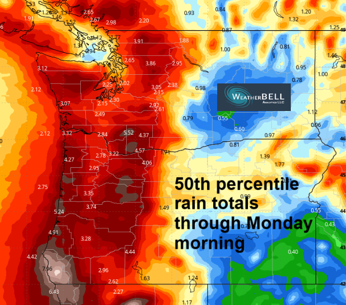
Rain continues this (Monday) morning until 10am or so all the way east past the Arlington Triangle into the Hermiston Hexagon and the Tri-Cities Rhombus. A break late morning is quickly followed by a cold front from the west that brings rain back to areas west of Mosier. East of Mosier, the clouds break up and the sun shines through, but if you go too far east, you’ll find clouds again. Sweet spot for sunshine: The Dalles. Overnight, much colder air arrives aloft. With partly cloudy sky around, we’re looking at the potential for icy roads all the way down to 84/14. Not for sure, but likely!
Tuesday’s Gorge weather forecast
Tuesday kicks off with 30 degrees and light snow prior to dawn as far east as Centerville in the WA hills and as far east as Hood River in the lowlands. Up to an inch of snow is possible in the more western elevated areas (Mill A, Trout Lake, Stabler, Parkdale, Middle Mountain, Snowden, Underwood). Partly cloudy sky returns by afternoon with highs in the low 40s. Wind will be light/variable.
Extended Gorge weather forecast
Wednesday starts mostly cloudy, turns mostly clear, and ends cloudy with light snow overnight down to 1000′ or less. With temps starting in the upper 20s, we’ll have widespread icy roads. Afternoon high: low 40s. Wind: light westerly. Models suggest a slightly higher chance of slightly more snow (up to an inch or two) on Thursday. Model agreement falls apart as we approach the wend of the week and the weekend. IT does look like we’ll have warmer air aloft and limited precipitation. That’s good, because warmer air aloft combined with cold air below and lots of precip is a recipe for an ice storm. That’s not in the cards at this point. Wetter weather is forecast to return next week.
Summary: expect icy roads and intermittent morning/overnight snow flurries starting Monday night. Safe travels. -TATAS
HEY! DON’T STOP READING! Is this community-focused forecast helpful to you? It sure is! It takes me a couple hours a day to write. Please join your friends and neighbors in contributing to keep it going. Venmo: @thegorgeismygym PayPal: twomirrors@gmail.com USPS: Temira / PO Box 841 / Hood River, Oregon 97031 You can test out the forecast subscription for a few days for free by signing up below. Easy! Do it!
JONES BEACH, SAUVIE ISLAND, & COAST FORECAST
ON WINTER VACATION UNLESS DESPERATELY NEEDED.
