

MT HOOD SNOW FORECAST

Hey skiers and snowboarders! It’s been a good night on Mt. Hood: both Timberline and Meadows are reporting 9” of new snow. Down at Teacup, things are more dire: it’s been a mix of rain and snow overnight with a saturated and ungroomable snowpack. That doesn’t bode well for the lower slopes of Skibowl.
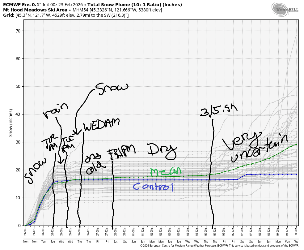
Generally speaking, temps will climb a bit over the next 24 hours, and snow will switch to rain mid-morning Tuesday. Don’t panic! Rain switches back to snow on Tuesday night with a favorable orographic situation. Beyond that… models generally keep things (mostly) dry for about 10 days, but they aren’t sure what sort of temps we’re facing along with the dry stretch.
Short term Mt Hood snow forecast
Monday brings snow, dense snow, but snow, to Mt Hood. The snow level will be around 4000′ early, 3000′ mid-morning, and temps will slowly rise overnight. A small difference in the location of this frontal system will make the difference between snow and rain. During the day, we’re expecting 0.4” water equivalent, for 4-5” snow at 5000′ with temps in the low 30s at 5000′; expect a break in the snow late morning. From late afternoon on into Tuesday morning, we’re expecting 1.0” water equivalent with temps ranging from -1C to +2C. This will probably result in very wet snow and potentially periods of mixed precip. I’m really guessing here, but let’s call for 3-6” new snow overnight. Maybe we’ll get lucky and get a foot! Wind will be W 25 this morning, SW 10-20 this afternoon, and SW 5-15 after midnight.
Snow switches to rain on Tuesday morning as temps on Mt Hood climb to +4C – mid-upper 30s. Overnight, a cold front swings through and takes temps back down to -5C! The snow level will be around 5000′ early, 6500′ mid-morning, 5500′ in the afternoon, and 1500′ after midnight thanks to a cold front moving in from the NW. During the day, we’re expecting about 0.6” WE of mixed precip – wet snow followed by rain. Overnight, models give us up to 0.6” WE of increasingly dry snow. Call it 4-6”. Wind will be SW 10-15 in the morning, SW 30-45 in the afternoon, W 45 in the evening (orographic support!), and W 35 after midnight.
Extended Mt Hood Snow Forecast
Orographic (terrain-enhanced) flurries are likely on Wednesday morning before partly cloudy, dry weather in the afternoon. The snow level will be 1500′ in the morning, 2000′ in the afternoon, and the free air freezing level will be 1500′ after midnight. Just an inch of snow is forecast in the morning before the sky turns clear. Wind: W 35 in the morning, WNW 20-25 in the afternoon, and W 10-15 after midnight.
Dry, sunny weather is forecast on Thursday and Friday with temps maxing out around 32F. Wind will be under 25mph on Thursday, but it may be stronger on Friday. Model agreement falls apart after Friday, but generally speaking, things look dry for most of the next ten days. See you on the slopes!
Was that helpful? I knew it was! Guess what? All of this crucial work – from your personal wind and snow reports to the invaluable TATAS updates – is made possible by my relentless efforts. Maintaining this labor of love isn’t easy. Each daily forecast takes hours. Website hosting, weather model access, and back-end admin work takes time and money. That’s where you come in.
YOUR CONTRIBUTION MAKES A DIFFERENCE
- SUPPORT ACCURATE, HYPER-LOCAL WEATHER FORECASTING
- ENABLE ACCESS FOR ALL, EVEN THOSE WITH LESS MEANS
- SUPPORT A COOL HUMAN WHO WORKS HARD SO YOU CAN PLAY
Take a moment to click one of the buttons below. Donate $19.99 or more (how much does this forecast enhance your life?) and get the email in your inbox. Whether it’s a renewing subscription (auto-renew) or a one-time donation, every contribution makes a real difference. Help me keep this labor of love alive, so we can all continue playing, commuting, and living in the Gorge with peace of mind and the best weather forecasts possible. Thank you!


Hood River, Oregon 97031


GORGE WIND FORECAST
If you’re still seeing yesterday’s and it’s after 9am, try opening this in an incognito window
SHORT-TERM gorge wind forecast
Hi friends! Not much happening today, but you’ll have easterlies (and pouring rain) on Tuesday if you want them. High pressure settles in offshore (or maybe in the Willamette Valley) from Wednesday onward giving us west wind of some sort. As of right now, it looks like the strongest westerlies will be overnight Tuesday into Wednesday as that high pressure builds, but we might still get lucky with west wind river time!
Monday, however, doesn’t give you much: light/variable wind in the morning and dead calm wind in the afternoon. River flow site is down again. River temp is 41.5F, and high temp forecast is 46F with lots of clouds and rain.
RIVER FLOW FOR SITES BETWEEN AVERY (EAST OF THE DALLES) AND RUFUS: CLICK HERE FOR JOHN DAY DAM FLOW.
RIVER FLOW FOR SITES BETWEEN STEVENSON AND DOUG’S BEACH (WEST OF THE DALLES): CLICK HERE FOR THE DALLES DAM FLOW

LONGER-TERM gorge wind forecast
Tuesday starts with E 40mph at Iwash (Rooster) Rock and E 30mph at Stevenson. By 1pm, the wind drops to 30mph at Iwash and 20-25mph at Stevenson. By mid-afternoon, the wind goes calm, and it turns westerly after dark. High temp: 46F with lots of rain.
Wednesday brings west wind. Models are all over the place with how much, but 22-25mph east of The Dalles seems likely with 12-15mph west of The Dalles. Thursday and Friday have a little more uncertainty but still seem like west wind days. Let’s keep watching them! See you on the river soon!
BARE BONES HOOD RIVER WEATHER FORECAST
Rain this morning and this afternoon and night with a break 10am-1pm ish. Temps start in the upper 30s and rise to the mid 40s. Calm wind. 76% chance of rainbows. Tuesday will be rainy all day. Temps start in the upper 30s and rise to the mid 40s. Light easterlies. 2% chance of rainbows. Wednesday will be showery early and partly cloudy later. Temps start in the mid 30s and rise to the upper 40s. Moderate westerlies. 81% chance of rainbows.
TEMIRA’S AWESOME TRAVEL ADVISORY SERVICE
HYPERLOCAL WEATHER FORECAST FOR THE COLUMBIA GORGE
THE DALLES, HOOD RIVER, WHITE SALMON, TROUT LAKE, STEVENSON, CASCADE LOCKS, PARKDALE, ODELL, HUSUM, BZ, MILL A, WILLARD, GOLDENDALE, RUFUS, ARLINGTON, boardman
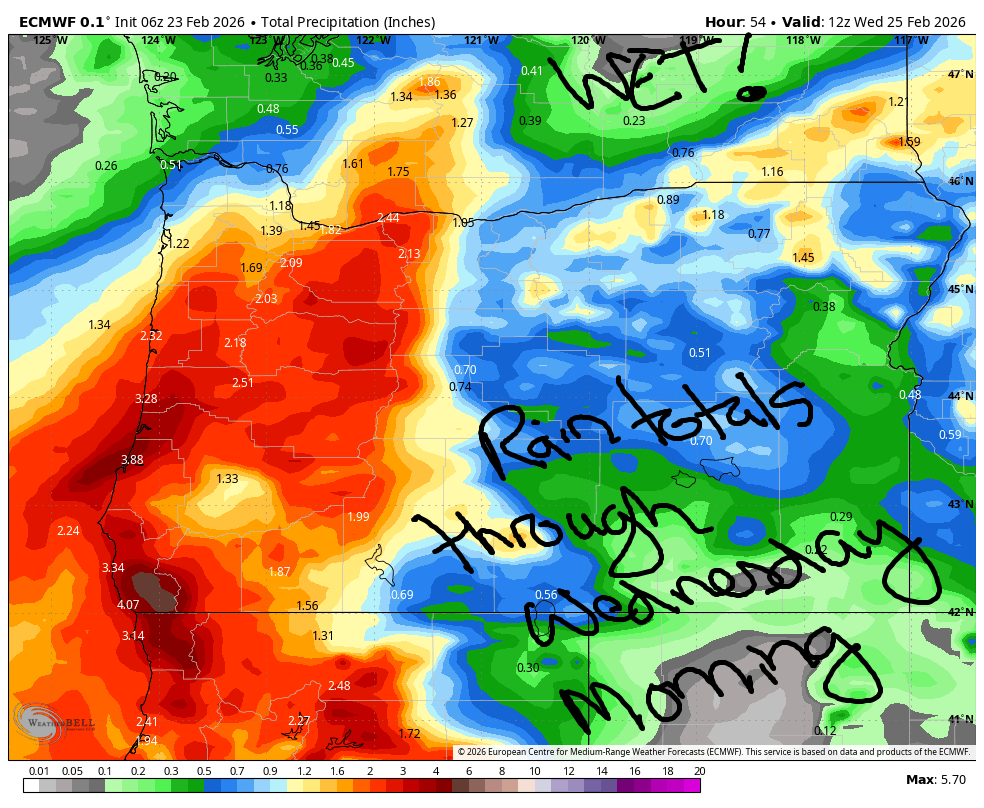
Good morning, neighbors! A couple of soaking wet days are on tap, even if you live in the desert, even if you live in south Wasco County, even if you live in Gilliam County, and especially if you live in Hood River or Skamania County. WET! WET! WET! Commute to/from the metro area: WET! Starting Wednesday midday, we’ll be dry for a while. DRY!
Glenwood this morning
Looking around the Gorge this morning, it’s gray. And wet. Glenwood started the day at 35F, and everyone is shaking their heads at the lack of pipe-freezing weather this winter. Nobody is disappointed in the lack of frozen pipes, to be clear. They’re happy, because less time spent on frozen pipes is more time spent, ahem, playing with one’s own pipe and the pipes of others.
Today’s Gorge weather forecast
Elsewhere in the Gorge, it’s cloudy and rainy all the way out past the Tri-Cities, where people are “tri”-ing to stay dry but not succeeding. North Bonneville already picked up 1.13” rain, Hood River 0.5”, a trace for The Dalles, and 0.22” in Goldendale. Rain continues through late morning, takes a break between Hood River and Hermiston for a few hours, and returns with a vengeance this afternoon. Today’s wind will be light and variable. Today’s high temps max out around 46F (west), 47F (The Dalles), and 50F (way out east). Heaviest rain for you commuters will be 4pm-10pm west of Hood River. Moderately heavy rain spreads all the way east past Arlington and into Sherman, Gilliam, and Wasco Counties after midnight.
Tuesday’s Gorge weather forecast
Tuesday starts with pouring rain and temps in the upper 30s. The sounding model suggests a few areas could be below freezing and picking up a little ice, but that really doesn’t make much sense given the above-freezing temps this morning, warm air aloft, and lack of clearing tonight. Let’s just call for rain. Commuters encounter pouring rain west of Hood River through 10am with light to moderate rain everywhere else that could even remotely be referred to as “The Gorge”. After 10am, the rain tapers off, but drizzle and/or sprinkles are possible through 4pm. Temps max out in the mid 40s. Wind will be E 40mph near Iwash (take down the pillars of authoritarianism!) Rock and E 30mph near Stevenson in the morning. After 4pm, the wind turns calm. Overnight, moderately strong westerlies swing through the Gorge.
Wednesday’s Gorge weather forecast
Wednesday starts with clouds to the west, clear sky to the east, and a snow level of 1500-2000′. Icy roads are possible in those clear-sky areas as morning temps drop into the low-mid 30s. We can’t rule out Parkdale waking up to a little bit of snow, but we can’t rule it in yet either, especially given the presence of west wind. Rest of the day: clearing skies to the west and sunny all day to the east with west wind at 15-25mph in the lowlands and high temps between the upper 40s (west) and low 50s (desert).
Extended Gorge weather forecast
Expect icy roads on Thursday morning away from the Nch’i Wana as clear sky allows radiational cooling to do its thing. Rest of the day: sunny. Dry weather is forecast for much of the next ten days, but the temp forecast is highly uncertain. Not in the picture: any sort of arctic outbreak with sub-freezing temps. The unusually warm and dry winter continues…. Safe travels. -TATAS
HEY! DON’T STOP READING! Is this community-focused forecast helpful to you? It sure is! It takes me a couple hours a day to write. Please join your friends and neighbors in contributing to keep it going. Venmo: @thegorgeismygym PayPal: twomirrors@gmail.com USPS: Temira / PO Box 841 / Hood River, Oregon 97031 You can test out the forecast subscription for a few days for free by signing up below. Easy! Do it!
JONES BEACH, SAUVIE ISLAND, & COAST FORECAST
ON WINTER VACATION UNLESS DESPERATELY NEEDED.
