

MT HOOD SNOW FORECAST

Hey skiers and snowboarders! While the extended forecast is very unclear, this week’s forecast is not – we’re looking at unseasonable warm temps in the mountains (and the valleys) with on-and-off chances for light drizzle and periods of sun breaks. Thank the stars (Sol in particular) for the cloud cover – the snowpack is fragile, and we need all the help we can to protect it!
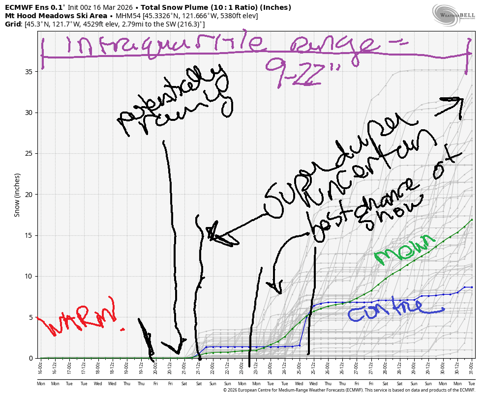
Short term Mt Hood snow forecast
Monday will be partly cloudy on Mt Hood and then clear. The free air freezing level will be well over 10,000′ all day. No precip. Wind will be WNW 35 early, SW 20-35 in the afternoon, and W 45-50 after midnight. Snow surface is partially transformed, high-humidity snow that’s working its way to granular. On Sunday, it softened up quickly. Expect the same today. Get it early, and wax yellow. High temp forecast for 5000′ is low 50s.
Tuesday will be partly high cloudy to start with some light drizzle form mid-morning on. The sky clears overnight. The snow level will be well above 10,000′ all day. Wind: W 45-50 early, W 30 mid-morning, WSW 15-20 in the afternoon, and W 30 after midnight. High temp at 5000′: upper 40s.
Extended Mt Hood Snow Forecast
Wednesday will be sunny in the morning and partly cloudy in the afternoon. The free air freezing level will be 10,000+. Wind will be W 30 in the morning, SW 20-35 in the afternoon, and SW 20-30 overnight. Thrusday also looks warm and breezy with high clouds. A bit of drizzle is possible late in the day. High temps will be somewhere in the upper 40s to low 50s.
Model consensus falls apart on Friday. At least some models have rain, but others are simply dry and cloudy. Uncertainty skyrockets as we head into next weekend, but it’s likely temps will stay above freezing. The intraquartile range for snowfall through the end of the month is 9-22”. I suggest you get up there and ride while you can, especially if you’re Nordic skiing!
Was that helpful? I knew it was! Guess what? All of this crucial work – from your personal wind and snow reports to the invaluable TATAS updates – is made possible by my relentless efforts. Maintaining this labor of love isn’t easy. Each daily forecast takes hours. Website hosting, weather model access, and back-end admin work takes time and money. That’s where you come in.
YOUR CONTRIBUTION MAKES A DIFFERENCE
- SUPPORT ACCURATE, HYPER-LOCAL WEATHER FORECASTING
- ENABLE ACCESS FOR ALL, EVEN THOSE WITH LESS MEANS
- SUPPORT A COOL HUMAN WHO WORKS HARD SO YOU CAN PLAY
Take a moment to click one of the buttons below. Donate $19.99 or more (how much does this forecast enhance your life?) and get the email in your inbox. Whether it’s a renewing subscription (auto-renew) or a one-time donation, every contribution makes a real difference. Help me keep this labor of love alive, so we can all continue playing, commuting, and living in the Gorge with peace of mind and the best weather forecasts possible. Thank you!


Hood River, Oregon 97031


GORGE WIND FORECAST
If you’re still seeing yesterday’s and it’s after 9am, try opening this in an incognito window
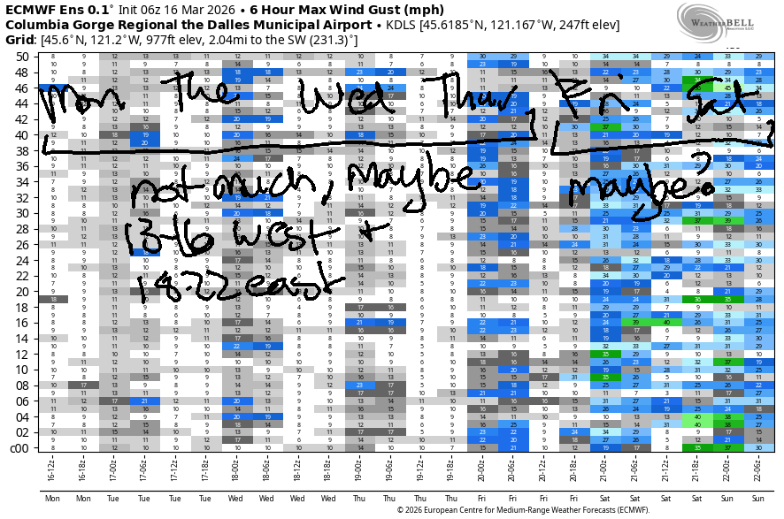
SHORT-TERM gorge wind forecast
Hi friends! Not much happening this week, although those of you with gear made for wind under 15mph could find yourself with an opportunity to play on the river.
Monday starts with pressures of 30.24/30.20/30.19 for gradients of 0.05/0.01. We’ll have light/variable wind to start the day. Westerlies slowly build to 13-16mph from Stevenson to Doug’s – strongest after 2pm. East of The Dalles, the wind rises to 10-13mph as far east as Rufus. River flow is notable: over the last 24 hours it was 229-278kcfs, (232-278kcfs at Rufus), river temp is 45.5F, and high temp forecast is 67F with clearing sky.
RIVER FLOW FOR SITES BETWEEN AVERY (EAST OF THE DALLES) AND RUFUS: CLICK HERE FOR JOHN DAY DAM FLOW.
RIVER FLOW FOR SITES BETWEEN STEVENSON AND DOUG’S BEACH (WEST OF THE DALLES): CLICK HERE FOR THE DALLES DAM FLOW

LONGER-TERM gorge wind forecast
Tuesday starts with 20-23mph from Viento to the Hatch prior to dawn, but it’s likely to fade quickly. By 8am, we’ll have 15-18mph from Viento to the Hatch, 10-13mph from Hood River to Doug’s, and 18-22mph near Rufus. The wind holds at 14-17mph in the west and 18-22mph out east and extends to Arlington until 2pm or so. After that: light wind, maybe even light/variable. High temp: 63F with clearing sky.
Wednesday starts with light west wind, under 10mph. It rises to 13-16mph from Stevenson to Hood River mid-morning. In the afternoon, mid-teens also pop up from Rufus to Arlington. High temp: 65F with partly cloudy sky. As of this morning (Monday), Thursday looks like 18-22mph from Doug’s to Rufus, but it could be more or less.
For the extended forecast, we have unusually high uncertainty. Some members of the ensembles have stronger westerlies in the Friday-Saturday time frame, but it’s not worth penciling that in yet. The probability is just too low. In the meantime, enjoy this warm, spring-like weather! Hope to see you on the Nch’i Wana soon!

BARE BONES HOOD RIVER WEATHER FORECAST
Mostly cloudy sky this morning. Temps start in the low 40s and rise to the upper 60s. Light westerlies. No rainbows. Tuesday will be mostly cloudy then mostly clear. Temp start in the upper 40s and rise to the low 60s. Moderate westerlies in the morning. Light westerlies later. No rainbows. Wednesday will be partly high overcast with a colorful sunrise then partly high overcast. Temps start in the upper 40s and rise to the mid 60s. Light westerlies. No rainbows.
TEMIRA’S AWESOME TRAVEL ADVISORY SERVICE
HYPERLOCAL WEATHER FORECAST FOR THE COLUMBIA GORGE
THE DALLES, HOOD RIVER, WHITE SALMON, TROUT LAKE, STEVENSON, CASCADE LOCKS, PARKDALE, ODELL, HUSUM, BZ, MILL A, WILLARD, GOLDENDALE, RUFUS, ARLINGTON, boardman
Good morning, neighbors! An uneventful week is on tap, but it’ll be notable for the unseasonable warmth. Records are generally 70-75F this week for Hood River, and we’re unlikely to set records. That said, T-shirt weather is in your future. From Thursday evening on, uncertainty is quite high, but winter is unlikely to make an appearance. That said… low temps next week could hover at or below freezing, so don’t go planting your tomatoes yet!
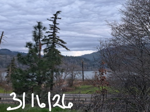
This morning in Glenwood
This morning in Glenwood, it’s 46 degrees, 40 degrees warmer than it should be in Glenwood on a late winter morning. Okay, that’s an exaggeration, but it’s still darn warm for Glenwood. On the roads around the Gorge: no ice, and no !CE. Speaking of !CE: I’m offering up an invitation to all you wonderful folks who drive by the Mercado on Sunday afternoons and give a honk or a thumbs up: please come join us in support of our immigrant neighbors. We’re there every Sunday from 3pm to 4pm. We’d love your company, even for just a short period of time, and your presence indicates to our immigrant neighbors that they are welcome and safe in your company. If you’d like to join a bigger demonstration against authoritarianism and unwanted wars, mark your calendar for 3/28. There are protests all across the country and lots of protests in the Gorge!!!
Today’s Gorge weather forecast
Weather for Monday: uneventful. After a cloudy start, the sky mostly clear. We’ll be left with just enough high clouds for a colorful sunset. Temps start in the low 40s along the river (colder than Glenwood!!!) and finish near 67 (SIX-SEVEN) degrees all the way from the west side out into the desert. Wind will be light to start (spray, baby, spray) and westerly at 10-15mph to finish as far east as Rufus.
Tuesday’s Gorge weather forecast
Moving on to Tuesday, most of us will have a partly cloudy start. A trace of rain is possible as far east as Cascade Locks from 5am to 8am. Other than that, dry weather is forecast with full-on sunshine by the afternoon. Morning temps will be mild: upper 40s. Afternoon temps will be … low 60s (west), mid 60s (The Dalles), and 69 (sexing it up in the desert). Wind will be west 20mph near Hood River to start with 15mph from Stevenson to Rufus midday. After noon, the wind drops and finishes up light and variable.
Wednesday’s Gorge weather forecast
High clouds Wednesday morning set us up for a beautiful sunrise. It’ll be plenty warm for photo-taking: upper 40s. Afternoon brings 65F (west) to 72F (desert) with light westerlies at 15mph or less. Clouds increase on Thursday, and rain is possible west of Cascade Locks. High temps will be 67 (SIX-SEVEN) to the west, 70F (The Dalles), and 74F (The Desert, where you can banana-hammock your day away thanks to the warmth).
Extended Gorge weather forecast
Model agreement collapses on Friday, just like you collapse at the end of the week. Beyond that, we’re just going to have to wait and see for a bit as model agreement remains low. Should you plant your tomatoes yet? No, but you should definitely have them, your brassicas, your peppers, your onions, asparagus and artichoke seeds started. Happy gardening. Safe travels. -TATAS
HEY! DON’T STOP READING! Is this community-focused forecast helpful to you? It sure is! It takes me a couple hours a day to write. Please join your friends and neighbors in contributing to keep it going. Venmo: @thegorgeismygym PayPal: twomirrors@gmail.com USPS: Temira / PO Box 841 / Hood River, Oregon 97031 You can test out the forecast subscription for a few days for free by signing up below. Easy! Do it!
JONES BEACH, SAUVIE ISLAND, & COAST FORECAST
ON WINTER VACATION UNLESS DESPERATELY NEEDED.

Leave a Reply