

MT HOOD SNOW FORECAST

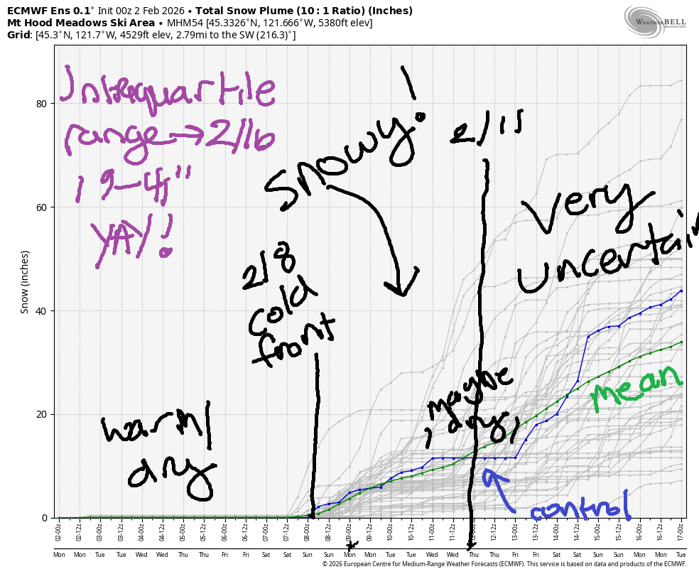
Hey skiers and snowboarders. Finally there’s some good news in the forecast! While this week looks (mostly) sunny and warm, the Euro insists that we’ll have a period of heavy snow next weekend and potentially more snow deeper into the future. There is some uncertainty beyond the 11th about temps and precip quantity, but it seem quite likely that we’ll get a season-saving snowfall before that. Fingers crossed! The intraquartile range (25th percentile to 75th percentile snowfall) through 2/16 is 19”-41”. Please, please let us get the 75th!
Short term Mt Hood snow forecast
But not today. Today will be a cloudy day on the mountain as a weak system passes to the north. I can’t rule out some mist and/or fog at the higher elevations, but I can’t rule it in either. The free air freezing level (FAF) will be 5500′ this morning, 7000′ this afternoon, and 9000′ overnight. Temps rise to nearly 40F on the slopes this afternoon. Wind will be SW 10-15 this morning, WSW 25-30 this afternoon, and light southerly overnight. Snow surface: dense, wet snow up high and wet granular down low.
Ridging (high pressure) takes over on Tuesday. The free air freezing level starts around 9000′ and rises to 12,000′ with temps at 5000′ rising to nearly 50 degrees under mostly clear sky. Wind will be S or SW 5-10mph all day. Negligible wind. Nice day!
Extended Mt Hood Snow Forecast
Wednesday starts with a few high clouds and then turns perfectly clear and with low humidity. The free air freezing level will be around 12,000′ all day, and temps at 5000′ will rise into the low 50s. Wind will be SE 10-20 in the morning, S 10-20 in the afternoon, and W 5-10 overnight.
That west flow ushers in slightly cooler (upper 40s) weather with a 10,000′ freezing level and full-on sunshine for Friday. Wind will be W 10-15 in the morning, 5-10 in the afternoon, and under 10mph overnight. Clear, mild weather continues on Saturday. Sunday’s our transition day unless this ridge lasts much longer than anticipated (which is a distinct possibility – these things often persist beyond the initial forecast). Anyway, models are clear that a NW-sourced cold front is planned late Sunday or early next week. That brings us some snow.
Cooler, wetter weather persists for at least a few days. During that time, we’re going to pick up some snow, but how much is unclear. Just vote for “lots’, please! Around the 11th, model uncertainty increases to the point where it’s impossible to tell if we’re looking at snow, rain, or nothing at all. I’ll leave it here for now. Enjoy the sunny weather this week!
Was that helpful? I knew it was! Guess what? All of this crucial work – from your personal wind and snow reports to the invaluable TATAS updates – is made possible by my relentless efforts. Maintaining this labor of love isn’t easy. Each daily forecast takes hours. Website hosting, weather model access, and back-end admin work takes time and money. That’s where you come in.
YOUR CONTRIBUTION MAKES A DIFFERENCE
- SUPPORT ACCURATE, HYPER-LOCAL WEATHER FORECASTING
- ENABLE ACCESS FOR ALL, EVEN THOSE WITH LESS MEANS
- SUPPORT A COOL HUMAN WHO WORKS HARD SO YOU CAN PLAY
Take a moment to click one of the buttons below. Donate $19.99 or more (how much does this forecast enhance your life?) and get the email in your inbox. Whether it’s a renewing subscription (auto-renew) or a one-time donation, every contribution makes a real difference. Help me keep this labor of love alive, so we can all continue playing, commuting, and living in the Gorge with peace of mind and the best weather forecasts possible. Thank you!


Hood River, Oregon 97031


GORGE WIND FORECAST
If you’re still seeing yesterday’s and it’s after 9am, try opening this in an incognito window
SHORT-TERM gorge wind forecast
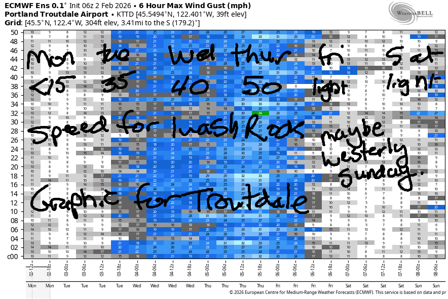
Hi friends! Another week of east wind is on tap, and it’s going to get strong enough for even the most picky of you! But Monday won’t be windy. As a matter of fact, it’ll be not-windy enough for the most picky of you. Easterlies prior to dawn were in the 7-13mph range. By early afternoon, the wind goes completely calm. River flow over the last 24 hours was 154-189kcsf, river temp is 40.6F, and high temp forecast is 50F with clouds in the morning and partly cloudy sky later.
Tuesday starts with E 35mph at Iwash/Rooster Rock and 25-30mph at Stevenson. The wind holds until early afternoon, when it drops to 25mph at both of those spots. High temp: 52F and partly cloudy.
RIVER FLOW FOR SITES BETWEEN AVERY (EAST OF THE DALLES) AND RUFUS: CLICK HERE FOR JOHN DAY DAM FLOW.
RIVER FLOW FOR SITES BETWEEN STEVENSON AND DOUG’S BEACH (WEST OF THE DALLES): CLICK HERE FOR THE DALLES DAM FLOW

LONGER-TERM gorge wind forecast
Strong easterlies are forecast on Wednesday. Iwash starts the day at 40mph, and Stevenson’s opening play is 25-30mph. Stevenson rises to 30mph mid-morning before dropping to 25mph in the afternoon. Iwash drops to 30-35mph in the afternoon. High temp: 52F and sunny in the windy zones.
Thursday looks like the windiest day of the week. Iwash maxes out at 50+, which gives us 35+ at Stevenson. High temp will be near 50F with sunshine in the windy zones. Lesser wind is forecast on Friday and Saturday. There are some hints of a possible west wind period in the Sunday-Monday time frame as a cold front slams into the PNW. Timing will be everything with this one. Fingers crossed! Stay safe out there – dress warmly, have an emergency plan, and keep an eye on your buddies!
BARE BONES HOOD RIVER WEATHER FORECAST
Nothing this morning. Partly cloudy later. Temps start in the low 40s and rise to 50. Calm wind. No rainbows. Tuesday will be Nothing then partly high cloudy. Temps start in the upper 30s and rise to the low 50s. Light easterlies. No rainbows. Wednesday will be Nothing then partly Nothing. Temps start in the upper 30s and rise to the low 50s. Light to moderate easterlies. No rainbows.
TEMIRA’S AWESOME TRAVEL ADVISORY SERVICE
HYPERLOCAL WEATHER FORECAST FOR THE COLUMBIA GORGE
THE DALLES, HOOD RIVER, WHITE SALMON, TROUT LAKE, STEVENSON, CASCADE LOCKS, PARKDALE, ODELL, HUSUM, BZ, MILL A, WILLARD, GOLDENDALE, RUFUS, ARLINGTON, boardman
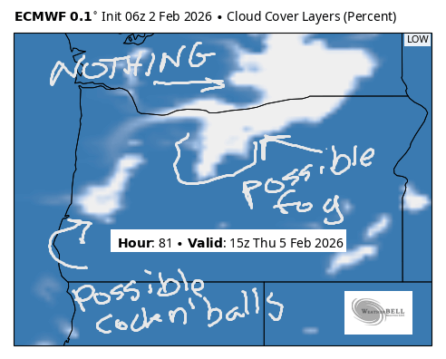
Good morning, neighbors! If you’re one of those people who work the traditional schedule (M-F), happy start of the work week to you! If not, may your day be a peaceful one, and may folks be nice to you. May you be nice to them too! Our weather plans to be “nice” this week, meaning we’re not looking at any snow or ice. We are, unfortunately, looking at some periods of Nothing. For the person in Sherman County who asked: we may be looking at fog for you on Wednesday into Thursday. I think. Not my area of expertise!
Glenwood this morning
Know what is my area of expertise? The morning temp in Glenwood! It’s 31F there this morning, tied with Centerville for coldest. Everyone in Glenwood is doing math this morning… “two times 31 is 62, and if you add 5 to that, you get… SIX SEVEN!!!!” Looks like everyone else is in the 34-39F range to start Monday, and everyone else is doing division instead of multiplication and addition. Instead of division, please try for understanding and compassion. They’re a lot more helpful than division. Roads seem to be pretty clear this morning; there are no reports of snow, sleet, ice, or ¡CE in the Gorge.
Today’s Gorge weather forecast
Weather today: a weak system is passing to the north of us. A few of you north of the Nch’i Wana (Big River) could get a little drizzle midday, but that’s not a promise. The rest of us will be cloudy this morning. After noon, the west side should be partly cloudy while the east side ends with high clouds and filtered sun. Temps rise to the low 50s today all across the lowlands. East wind at 15mph in the usual spots this morning dies off and leaves us with calm wind in the lowlands. If you’re high enough in the hills, you’ll encounter SW wind at 20mph.
Tuesday’s Gorge weather forecast
Mostly clear to partly high overcast sky Monday night allows a small Nothing to develop near the river for Tuesday morning. Areas near the river stay partly Nothing on Tuesday while areas away from the river or in the west-side windy zones turn partly high overcast with plenty of sun. Morning temps will be in the upper 20s to low 30s away from the Nothing and in the mid to upper 30s in and below it. By afternoon, high temps rise to the low-mid 50s. Head to Iwash (by “files”, we meant “stop redacting the pedos’ names”) Rock for easterlies at 35mph. Head to Stevenson for 25-30mph. Head east of Viento for light wind.
Extended Gorge weather forecast
On Wednesday, Thursday, and Friday, we’ll have partnered up (u-hauled) with a strong ridge of high pressure. Each day gives us slightly cooler mornings, slightly more areal coverage of Nothing, and strong east wind west of Viento. High temps each day are forecast to be in the low 50s, but you’re probably going to have to get above the Nothing to experience that. Equally-warm temps are forecast for the (desperate) ski areas and in the mountains. Nice days are coming for mid-elevation hiking!
We finally break out of this pattern late next weekend as a cold front arrives from the NW. It’ll bring some moisture, thankfully. It’s highly unlikely to bring lowland snow or ice or travel concerns. Remember, that’s why this forecast got started: because it used to snow and sleet and ice and shut down the roads around here. Now it’s just Nothing. Paraphrasing the Neverending Story (best movie ever) there, in case you didn’t catch it. Safe travels. -TATAS
HEY! DON’T STOP READING! Is this community-focused forecast helpful to you? It sure is! It takes me a couple hours a day to write. Please join your friends and neighbors in contributing to keep it going. Venmo: @thegorgeismygym PayPal: twomirrors@gmail.com USPS: Temira / PO Box 841 / Hood River, Oregon 97031 You can test out the forecast subscription for a few days for free by signing up below. Easy! Do it!
JONES BEACH, SAUVIE ISLAND, & COAST FORECAST
ON WINTER VACATION UNLESS DESPERATELY NEEDED.
