

GORGE WIND FORECAST
today’s gorge wind forecast
Hi friends! In an interesting twist this morning, we have a fine example of how tricky the Gorge wind forecast can be: at dawn, models were suggesting dawn patrol at 25mph+, and reality had us with dawn patrol, I mean “TJ’s Dawn Patrol”, at 10mph. We’ll talk more about today in a bit. Looking at this week, we’ve got wind every day. The least of the days is Tuesday, and even then, we’re expecting teens in the Corridor and mid 20s to the east. Looking at the extended forecast in the Euro ensembles, we have our next shot at a true rest day at the beginning of next week. Maybe. Uncertainty is high!
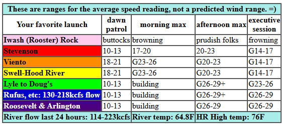
Let’s look at today: pressures started with 30.07/29.97/29.94 for gradients of 0.10 and 0.03. This would indicate a Corridor day, but an approaching front will make the wind more widespread. With cloud cover lacking in the metro area, we’re relying on a cool air refresh for our temp gradient today. We’ve also lost the strong NE Pacific High, which will nudge potential downward. There are some other factors at play that hint at reality under-performing today and the wind being gustier than usual.
Even so… we should see westerlies rise to 23-26 from Stevenson to Mosier by mid-morning with 20-23 as far east as Rufus. 25-28 from Viento to Swell isn’t out of the question, but those limiting factors will make it tough. We’re likely to see Stevenson-Hood River drop to gusty 18-22 this afternoon as the metro area heats. Viento may hold – it often does when fronts get involved. From Mosier to Rufus this afternoon, we’re looking at 26-29 with a shot at 28-31 from Avery to Arlington. After 5pm, the wind drops to gusty 14-17 from Stevenson to Mosier with 23-26ish from Lyle to Doug’s and 26-29ish from Avery to Threemile. River flow over the last 24 hours was 114-223kcfs (130-218kcfs at Rufus), river temp is 64.8F, and high temp forecast is 76F for Hood River and 83F for Arlington.
RIVER FLOW FOR SITES BETWEEN AVERY (EAST OF THE DALLES) AND RUFUS: CLICK HERE FOR JOHN DAY DAM FLOW.
RIVER FLOW FOR SITES BETWEEN STEVENSON AND DOUG’S BEACH (WEST OF THE DALLES): CLICK HERE FOR THE DALLES DAM FLOW

tomorrow’s gorge wind forecast
That frontal system I mentioned will still be in the picture on Tuesday, and that will impact wind quality. It’ll still be windy. No rest day for you. The day starts with 12-15 from Stevenson all the way to Boardman. Westerlies rise to 14-17 from Stevenson to Hood River late morning with 18-21 from Mosier to Arlington. Afternoon sees a brief period of 20ish at Stevenson-Mosier before a return to 14-17. Out east, we’ll see 24-27 from Lyle to Rufus and 20-23 at Arlington. High temp: 78F for Hood Rive rand 82F for Arlington.
extended Gorge wind forecast
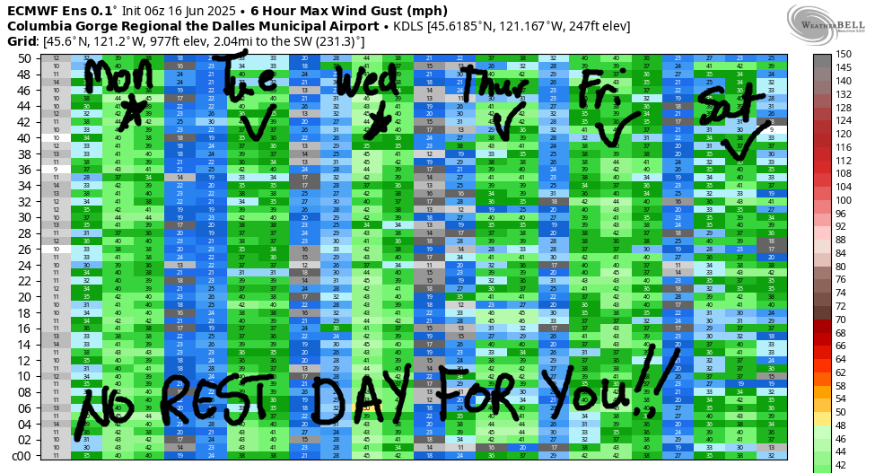
On Wednesday, a weather system drives clouds into the metro area, and high pressure rebuilds off the Oregon coast. The day starts with 11-14 form Stevenson to Doug’s with 20-23 out east. Afternoon wind rises to gusty 22-26 form Stevenson to Mosier as the clouds burn back with 26-29+ from Lyle to Arlington and 23-26 at Threemile. I suspect the wind will over-perform on Wednesday thanks to the clouds. High temp: 74F for Hood River and 79F for Arlington. A strong day is in the cards for Thursday all the way from Stevenson to the desert. Friday: windy out east as we start to see showers on the west side. Ditto for Saturday. Sunday brings quite a bit of uncertainty depending on where a low pressure system settles and what it does next. Looking beyond that, uncertainty continues, but there’s at least a slight chance of a rest day early next week. Maybe! Have a great day on the river today!
Was that helpful? I knew it was! Guess what? All of this crucial work – from your personal wind and snow reports to the invaluable TATAS updates – is made possible by my relentless efforts. Maintaining this labor of love isn’t easy. Each daily forecast takes hours. Website hosting, weather model access, and back-end admin work takes time and money. That’s where you come in.
YOUR CONTRIBUTION MAKES A DIFFERENCE
- SUPPORT ACCURATE, HYPER-LOCAL WEATHER FORECASTING
- ENABLE ACCESS FOR ALL, EVEN THOSE WITH LESS MEANS
- SUPPORT A COOL HUMAN WHO WORKS HARD SO YOU CAN PLAY
Take a moment to click one of the buttons below. Donate $19.99 or more (how much does this forecast enhance your life?) and get the email in your inbox. Whether it’s a renewing subscription (auto-renew) or a one-time donation, every contribution makes a real difference. Help me keep this labor of love alive, so we can all continue playing, commuting, and living in the Gorge with peace of mind and the best weather forecasts possible. Thank you!


Hood River, Oregon 97031


JONES BEACH, SAUVIE ISLAND, & COAST FORECAST
Wind northerly unless otherwise indicated. For coast, it’s North/Central/South with the “central” at approximately Florence. Swell forecast from NWS for central coast. Jones: westerly unless otherwise stated. Sauvie Island: northerly unless otherwise stated. Monday: LTNW/LTNW/N15-20, NW swell 3′ at 8 seconds and S 2′ @ 17 seconds. Tuesday: LTW/LTW/N15-20, W 5′ @ 10. Wednesday: NW5-10/NW10/N25-30, @ 4′ @ 7. Jones Monday: 19-22. Tuesday: LTW. Wednesday: 8-11. Sauvie Island Monday: 15-18 > 5pm. Tuesday: 10-13. Wednesday: 10-13.
BARE BONES HOOD RIVER WEATHER FORECAST
Monday will be mostly clear then partly cloudy then clear. Temps start near 50 and rise to the mid 70s. Strong westerlies. No rainbows. Tuesday will be clear. Temps start near 50 and rise to the upper 70s. Moderate westerlies. No rainbows. Wednesday will be cloudy with a chance of a few sprinkles early and partly cloudy to clear in the afternoon. Temps start in the mid 50s and rise to the upper 70s. Moderate westerlies. 1.5% chance of rainbows.
TEMIRA’S AWESOME TRAVEL ADVISORY SERVICE – MONDAY 6/16
HYPERLOCAL WEATHER FORECAST FOR THE COLUMBIA GORGE
THE DALLES, HOOD RIVER, WHITE SALMON, TROUT LAKE, STEVENSON, CASCADE LOCKS, PARKDALE, ODELL, HUSUM, BZ, MILL A, WILLARD, GOLDENDALE, RUFUS, ARLINGTON, boardman
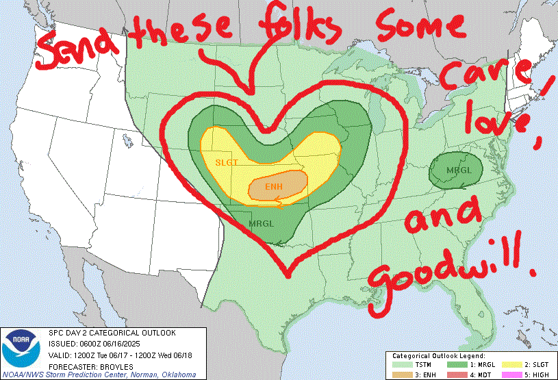
Good morning, neighbors! Looks like a nice week on tap – high temps for The Dalles will (except today) be under 80 degrees. That’s cool as a cucumber, but not the cucumber you used as a dildo. That cucumber’s about 98.6 degrees now. Unless you froze it first. Speaking of cucumbers, it’s entirely possible we’ll see measurable rain as far east as Mosier or Rowena on Friday. We (meaning my friend Maude and I and all the other cherry farmers) are keeping a close eye on this. People who are in favor of rain – pretty much all of us thanks to a very dry spring and a very early and very sobering start to fire season. As for the cherries – thankfully the incoming rain should be 1) quite cold, and 2) accompanied by wind. In other weather news… send our friends in the central USA some love – they have an enhanced chances of severe storms today. SPC appears to be sending them love in the graphical forecast. We should too!
Glenwood this morning
Checking in with our friends in Glenwood… it was 35 degrees there this morning. AMAZING!
today’s gorge weather forecast
On to today’s weather. Windy from Stevenson to Mosier early and windy from Stevenson to Arlington later. Windy = 25-35mph or so. In the afternoon, thanks to a barely-a-weather-system approaching the coast, we’ll have some high clouds. Hopefully they’ll stick around into the evening and transform from clouds into reflectors of late-day sunbeams. In other words, there’s a good chance of a colorful sunset. Temps today rise from 50ish to 75 (west) and 82 (The Dalles) and 83 (Arlington Triangle) and 37 (McCurdy Farms cold storage) and 97.3 (TATAS’ hoo-ha).
tuesday’s gorge weather forecast
Clear sky overnight into Tuesday leads to a 50 degree morning. Afternoon temps rise to 80ish pretty much everywhere. Westerlies at 15mph all the way from Stevenson to Arlington in the morning rise to 20mph (west of The Dalles) and 25-30mph (east of The Dalles) in the afternoon. Other than a few mid-level clouds in the afternoon, the sky will be clear as a shatterproof glass dildo after a run through the dishwasher with whatever that detergent is that makes things clear and sparkly. I don’t have a dishwasher, so I’m not familiar with detergent brands.
wednesday’s gorge weather forecast
Wednesday bring something different: a little bit of drizzle west of Mosier or maybe west of Hood River. For the Cascade Crest, models have a trace to 0.2”. For the lowlands: just a trace. East of the Cascade crest, the sky will be clear all day. West: cloudy in the morning and partly to mostly cloudy in the afternoon. High temps rise to the mid 70s (west), upper 70s (The Dalles), and upper 80s (watermelon growing zone near Hermiston). This results in west wind. Again. 10-15mph under the clouds in the morning with 20-25mph east of the clouds. Afternoon wind rises to 25mph west of Mosier and 25-35mph from Mosier east to the Arlington Triangle and beyond.
extended gorge weather forecast
Thursday: windy and sunny with temps in the low 70s.
Now, let’s look at the Friday-Sunday period. An organized low pressure system approaches and eventually moves inland. Rain chances start on Friday morning and continue through Sunday, but it’s far from clear how much rain we’ll see. Along the Cascade crest and for areas west of Viento, models give a good chance of 0.25” to 0.5” total by Sunday morning. Rain totals fall dramatically as we look east: for The Dalles, models have a trace to 0.12” there, and even less for the Maryhill cherries. Parkdale and the west side of Hood River could see 0.1” to 0.2” total. East side of Hood River and Mosier: less. The caveat to this is that instability on Saturday and Sunday could result in brief heavy showers if there are enough sunbreaks. High temps for the period will be approaching record cool: 66 for Friday, 63 for Saturday (a record, if it happens), and 68 for Sunday. Add in extensive clouds and moderate to strong west wind for a best-case-possible scenario for the possibility of rain on ripening cherries. I’ll keep looking at this each day and trying to refine this forecast.
From Sunday on, uncertainty enters the picture like a cat photo-bombing a twerking video. (Yes, I have a video of my cat photo-bombing me practicing twerking) While there’s a ten-degree range in high temps starting early next week, the possibilities stay under 90 degrees every day and under 80 degrees most days. This ain’t great weather for growing watermelons, but it’s great weather for existing as a human being on the planet. Safe travels. -TATAS
HEY! DON’T STOP READING! Is this community-focused forecast helpful to you? It sure is! It takes me a couple hours a day to write. Please join your friends and neighbors in contributing to keep it going. Venmo: @thegorgeismygym PayPal: twomirrors@gmail.com USPS: Temira / PO Box 841 / Hood River, Oregon 97031 You can test out the forecast subscription for a few days for free by signing up below. Easy! Do it!
