

GORGE WIND FORECAST
If you’re still seeing yesterday’s and it’s after 9am, try opening this in an incognito window
today’s gorge wind forecast
Hi friends! Fun times this week – widespread easterlies today in response to a one-two punch of weather features. Lingering easterlies tomorrow. West wind returns to the Gorge wind forecast Wednesday afternoon with the approach of a cool trough from the northwester. Thursday continues to hold potential for a big day, first at the Hatch, then at Rufus. Associated west wind may or may not linger into Friday – models have varying ideas for that day, but my best guess is … YES.
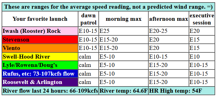
Not much was happening to start Monday morning. Pressures were basically flat, and wind was east at 10mph or so at the usual east wind spots (Iwash/Rooster, Stevenson, Home Valley, Viento). As a low moves south along the coast and a cold front approaches from the northeast, east wind picks up all through the Gorge. By late morning or early afternoon, Iwash (Rooster) Rock builds to 25mph, Stevenson rises to 20mph, and Viento rises to 15-20mph. In a fun twist, easterlies fill in at 10-15mph east of Viento to Hood River with 15-20mph east wind east of Mosier all the way out into the desert. After 2pm, the wind drops to 20mph at Iwash, 15mph at Stevenson, and 10-15mph everywhere else. River flow over the last 24 hours was 66-109kcfs, river temp is 64.6F, and high temp forecast for Hood River is just 54F with clearing sky.
RIVER FLOW FOR SITES BETWEEN AVERY (EAST OF THE DALLES) AND RUFUS: CLICK HERE FOR JOHN DAY DAM FLOW.
RIVER FLOW FOR SITES BETWEEN STEVENSON AND DOUG’S BEACH (WEST OF THE DALLES): CLICK HERE FOR THE DALLES DAM FLOW

tomorrow’s gorge wind forecast
Easterlies continue on Tuesday. For the morning, you’ll find 20-25mph at Iwash (Rooster) Rock, 15-20mph at Stevenson, and 15-20mph at Viento. After noon, Stevenson and Iwash level out at 15-20mph, and Viento drops to 15mph. By 5pm, all the spots previously mentioned will be at 10-15mph or less. High temp for Hood River: 59F with clear sky.
extended Gorge wind forecast
Wednesday starts with easterlies at 10mph or so. We’ll see a slow west wind build in the afternoon. By mid-afternoon, Stevenson to Hood River will be at 13-16mph. For the executive session (after 5pm), 17-20mph is possible from Stevenson to Rufus, but that stronger wind might not arrive until dark. High temp forecast: 64F and sunny.
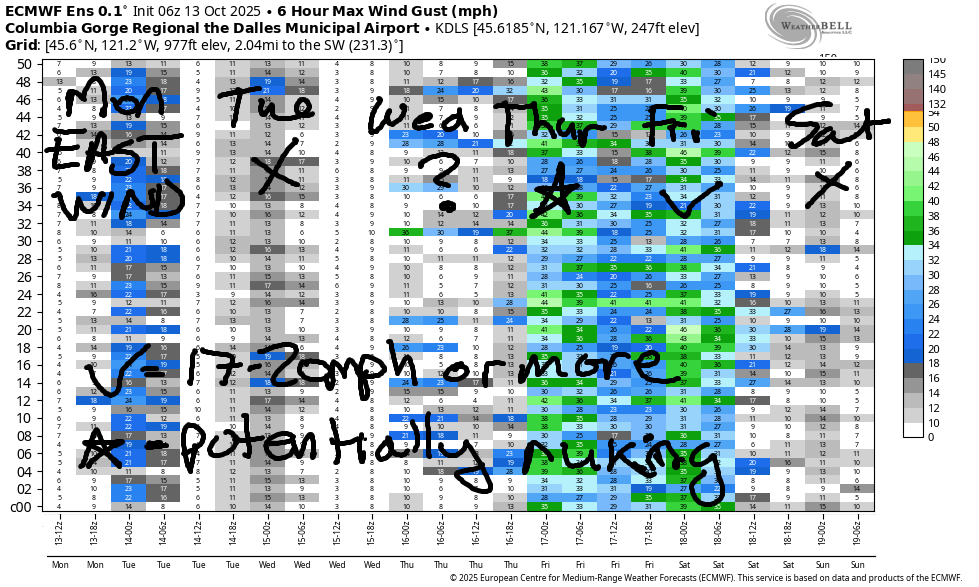
Low clouds slide inland on Wednesday night and continue to build into the day Thursday as a trough settles in at the coast. This gives us strong westerlies from Viento to Mosier in the morning and strong westerlies from Stevenson (?) or Viento (yes) to Rufus or maybe even Arlington in the afternoon. The Euro ensemble isn’t fully on board with the Rufus/Arlington scenario, but it seems like a good setup to me. In an interesting twist, the GFS deterministic basically shuts the wind off on Friday while the Euro repeats Thursday. So… no consensus there yet, but I’m leaning towards “windy” for both days. Weekend: Saturday looks light. Sunday has some potential as a weather system approaches. That’s all for now. Have a great day. See you on the Nch’i Wana!
Was that helpful? I knew it was! Guess what? All of this crucial work – from your personal wind and snow reports to the invaluable TATAS updates – is made possible by my relentless efforts. Maintaining this labor of love isn’t easy. Each daily forecast takes hours. Website hosting, weather model access, and back-end admin work takes time and money. That’s where you come in.
YOUR CONTRIBUTION MAKES A DIFFERENCE
- SUPPORT ACCURATE, HYPER-LOCAL WEATHER FORECASTING
- ENABLE ACCESS FOR ALL, EVEN THOSE WITH LESS MEANS
- SUPPORT A COOL HUMAN WHO WORKS HARD SO YOU CAN PLAY
Take a moment to click one of the buttons below. Donate $19.99 or more (how much does this forecast enhance your life?) and get the email in your inbox. Whether it’s a renewing subscription (auto-renew) or a one-time donation, every contribution makes a real difference. Help me keep this labor of love alive, so we can all continue playing, commuting, and living in the Gorge with peace of mind and the best weather forecasts possible. Thank you!


Hood River, Oregon 97031


JONES BEACH, SAUVIE ISLAND, & COAST FORECAST
ON WINTER BREAK. MAY SHOW UP OCCASIONALLY AS NEEDED.
BARE BONES HOOD RIVER WEATHER FORECAST
Mostly cloudy sky this morning mostly clears later. Temps start in the low 40s and rise to the mid 50s. Calm wind early. Moderate easterlies later. No rainbows. Tuesday will be sunny. Temps start in the mid 30s and rise to the upper 50s. Light easterlies. No rainbows. Wednesday will be partly Nothing then clear. Temps start in the upper 30s and rise to the mid 60s. Calm wind early. Moderate west wind late. No rainbows.
TEMIRA’S AWESOME TRAVEL ADVISORY SERVICE
HYPERLOCAL WEATHER FORECAST FOR THE COLUMBIA GORGE
THE DALLES, HOOD RIVER, WHITE SALMON, TROUT LAKE, STEVENSON, CASCADE LOCKS, PARKDALE, ODELL, HUSUM, BZ, MILL A, WILLARD, GOLDENDALE, RUFUS, ARLINGTON, boardman

Good morning, neighbors! Cloud cover this morning spared us from frost, but it won’t be here to save us tomorrow. We’re looking at our first shot at a widespread frost/freeze. Unless you’re right near the Nch’i Wana or west of Underwood down low, prepare!
Glenwood this morning
Enough clouds were out and about this morning to keep even Glenwood above freezing: 42 degrees there to start the day. Glenwood residents had their coffee in camelbacks today because they’re desperately scrambling to prepare for a very cold morning tomorrow. At least they have the option to wear clothes, just like the protesters in Portland yesterday: clothing optional bike ride. Know what those folks were protesting: Injustice in the form of ICE brutality; injustice in the form of military being deployed to oppress Blue cities; injustice in the form of oppression against trans, Black, Indigenous, POC, queer, female, disabled, and otherwise not White-cis-male-straight people. If you belong to that last category, please stand up and help the rest of us. Injustice anywhere is a threat to justice everywhere. (-MLK, seen on the building in the photo)
Today’s Gorge weather forecast
Back to the Gorge, back to not-Glenwood people: everyone else around the Gorge was just having a Monday. I decided to start my Monday by sleeping in for the first time in a good long while. I got 10 hours of zzzzzzzz! Thankfully my cat was on board and chose to cuddle rather than stomping back and forth across my head demanding food. THANKS, KITTY! Today’s weather: after a 40-45 degree start, we’ll finish in the mid 50s, except way out near Pasco, where low 60s are the forecast. A cold front moving in from the NE brings cool, low-humidity air this afternoon. That melts away the clouds and leaves us set for a chilly night.
Tuesday’s (frosty) Gorge weather forecast
With 850mb temps around 0C, clear sky, and light wind, we’ll see widespread frost on Tuesday morning. Right near the Nch’i Wana, the dewpoint should be high enough for a protective Nothing. Between Iwash (wang) Rock and Viento, it will be breezy enough to prevent sub-freezing temps. Locations set for a hard freeze: Trout Lake, Glenwood (duh), Parkdale, High Prairie, Centerville, Goldendale, Appleton. Frosty areas: elevated parts of Mosier, Cherry Heights, Steele Road area of The Dalles, Odell, potentially White Salmon and the elevated parts of Hood River, South Wasco County. My house: no frost. My garden: yes frost. Rest of Tuesday: sunny and 60ish degrees all across the lowlands. Morning easterlies will be 20-25mph near Iwash Rock and 15-20mph at Stevenson. Afternoon: 10-15mph. Hills: east wind at 10mph.
Extended Gorge weather forecast
Wednesday starts with a partial Nothing clouds. Another round of frost is likely, but it won’t be as intense as on Tuesday. Temps max out in the mid 60s (west), upper 60s (The Dalles), and low 60s (The Desert). Light/variable wind early becomes westerly at 15-20mph late in the day between Stevenson and Rufus. Sky cover: clear all day becoming cloudy on the west side overnight.
Thursday looks cloudy to the west and sunny to the east with strong west wind. High temps: 60-65 degrees. Friday looks similar. A calmer, slightly warmer day is forecast Saturday. Sunday: probably rainy, perfect for watching SPORTSBALL!!!! GO SEAHAWKS! Safe travels. -TATAS
HEY! DON’T STOP READING! Is this community-focused forecast helpful to you? It sure is! It takes me a couple hours a day to write. Please join your friends and neighbors in contributing to keep it going. Venmo: @thegorgeismygym PayPal: twomirrors@gmail.com USPS: Temira / PO Box 841 / Hood River, Oregon 97031 You can test out the forecast subscription for a few days for free by signing up below. Easy! Do it!
MT HOOD SNOW FORECAST

CURRENTLY ON VACATION. WILL RETURN SOMETIME BEFORE THE START OF SKI SEASON AT MEADOWS, TIMBERLINE AND SKIBOWL. SAME GOES FOR THE NORDIC SKIING SEASON AT MEADOWS AND TEACUP!

Leave a Reply