

GORGE WIND FORECAST
If you’re still seeing yesterday’s and it’s after 9am, try opening this in an incognito window
today’s gorge wind forecast
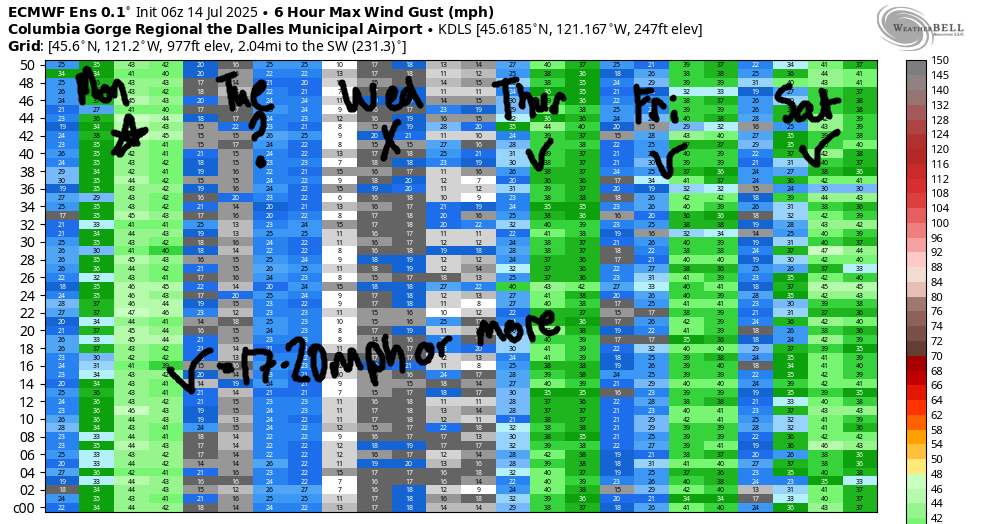
Hi friends! A windy, windy day is on tap today (it’s Monday). We’ll see much lighter wind Tuesday and Wednesday as high pressure pushes inland and temps climb. The less-windy weather will be short-lived: we’re back to westerlies in the Gorge wind forecast on Thursday, and they’ll stick around through the extended forecast period.
Looking at this morning, we have a cool trough approaching the area. This does a few helpful things: it creates a big cross-Cascade temp gradient, it stabilizes the air mass on the west side, and it adds in support from NW upper-level wind. Offshore, we have very strong high pressure at 1032mb to aid the big picture. Only thing lacking: clouds on the west side. Models do suggest marine air may filter in to the metro area through late morning, which can only help us here in the Gorge. It’s going to be a good one!
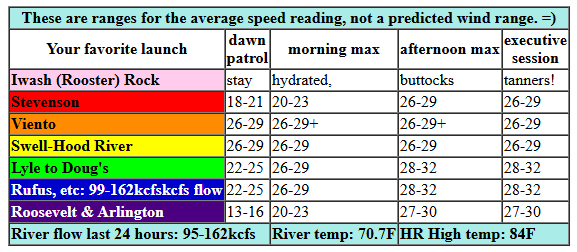
We started the day with pressures of 30.08/29.95/29.94 for gradients of 0.13 (PDX-DLS) and 0.01 (DLS-PSC). Westerlies were in the low to mid 20s from Viento to Rufus to start the day. We’ll see a quick build to 26-29mph from Viento to Mosier for the early session with 22-25 between Lyle and Rufus. Midday wind fills in at 26-29 (maybe even a little stronger) between Stevenson (lower end of that range) to Avery. Don’t be surprised if the wind touches 30mph average here and there! Afternoon: 26-29 from Stevenson to Hood River with 28-31 from Mosier to Rufus. Mid-afternoon carries potential for 30-34 between Mosier and Rufus with 27-30 east of Rufus to Threemile. Sounds like a nice day on the river for those of us who like it strong! River flow over the last 243 hours was 95-162kcfs (99-162kcfs at Rufus), river temp is 70.7F, and high temp forecast is 84F for Hood River and 91F for Arlington.
RIVER FLOW FOR SITES BETWEEN AVERY (EAST OF THE DALLES) AND RUFUS: CLICK HERE FOR JOHN DAY DAM FLOW.
RIVER FLOW FOR SITES BETWEEN STEVENSON AND DOUG’S BEACH (WEST OF THE DALLES): CLICK HERE FOR THE DALLES DAM FLOW

tomorrow’s gorge wind forecast
The picture looks much, much different on Tuesday, but hey, it looks better than it did in yesterday’s forecast – at least we’ll have west wind, not easterlies! We start the day with west wind at 16-19mph between Viento and Swell. The wind drops as the day goes on and eventually lands at 7-10mph between Stevenson and Swell. High temp: 90F for Hood River with sunny sky all day.
extended Gorge wind forecast
Wednesday looks light and variable. To be more precise, we’ll have calm wind to start, E 10mph near Stevenson midday, and W 12-15mph between Stevenson and Swell late afternoon into the evening. To the east of Hood River, the wind will either be calm (near Rowena) or easterly at 5-10mph (east of The Dalles). High temp: 93F for Hood River and pretty much everywhere else!
There’s some uncertainty for the latter half of the week, but the wind generally looks westerly. The hottest weather shifts to the east side, and this turns the wind onshore; let’s call it low to mid 20s for Thursday and Friday. Models hint at cooler temps on the west side this weekend thanks to an approaching trough. If that plays out, both weekend days will be strong. All-in-all, this looks like a darn nice stretch of wind other than Tuesday and Wednesday. Go wear yourself out today so you can take advantage of that proffered rest! See you on the Nch’i Wana!
Was that helpful? I knew it was! Guess what? All of this crucial work – from your personal wind and snow reports to the invaluable TATAS updates – is made possible by my relentless efforts. Maintaining this labor of love isn’t easy. Each daily forecast takes hours. Website hosting, weather model access, and back-end admin work takes time and money. That’s where you come in.
YOUR CONTRIBUTION MAKES A DIFFERENCE
- SUPPORT ACCURATE, HYPER-LOCAL WEATHER FORECASTING
- ENABLE ACCESS FOR ALL, EVEN THOSE WITH LESS MEANS
- SUPPORT A COOL HUMAN WHO WORKS HARD SO YOU CAN PLAY
Take a moment to click one of the buttons below. Donate $19.99 or more (how much does this forecast enhance your life?) and get the email in your inbox. Whether it’s a renewing subscription (auto-renew) or a one-time donation, every contribution makes a real difference. Help me keep this labor of love alive, so we can all continue playing, commuting, and living in the Gorge with peace of mind and the best weather forecasts possible. Thank you!


Hood River, Oregon 97031


JONES BEACH, SAUVIE ISLAND, & COAST FORECAST
Wind northerly unless otherwise indicated. For coast, it’s North/Central/South with the “central” at approximately Florence. Swell forecast from NWS for central coast. Jones: westerly unless otherwise stated. Sauvie Island: northerly unless otherwise stated. Coast Monday: 10-15/20-25/35+, NW swell 7′ at 9 seconds. Tuesday: 10-15/10-15/30-35, NW 7′ @ 9. Wednesday: 15/15-20/20, NW 7′ @ 9. Jones Monday: 20-23. Tuesday: 15-18. Wednesday: 19-22. Sauvie Island Monday: 13-16. Tuesday: 12-15. Wednesday: 13-16.
BARE BONES HOOD RIVER WEATHER FORECAST
Clear sky all day. Temps start in the low 70s and rise to the mid 80s. Strong westerlies. No rainbows. Tuesday will be sunny. Temps start in the upper 50s and rise to 90 or so. Moderate westerlies early. Light westerlies later. No rainbows. Wednesday will be clear. Temps start in the lo w60s and rise to the low 90s. Calm wind most of the day. Light westerlies late. No rainbows.
TEMIRA’S AWESOME TRAVEL ADVISORY SERVICE
HYPERLOCAL WEATHER FORECAST FOR THE COLUMBIA GORGE
THE DALLES, HOOD RIVER, WHITE SALMON, TROUT LAKE, STEVENSON, CASCADE LOCKS, PARKDALE, ODELL, HUSUM, BZ, MILL A, WILLARD, GOLDENDALE, RUFUS, ARLINGTON, boardman

Good morning, neighbors! Thanks to the high humidity and the overnight wind, most of us are starting Monday quite warm – 70 degrees! Fortunately, the morning lows will be cooler the next few days and the humidity will be lower. I say fortunately, because we’re headed into another strong of hot days. Relief is possible, but not certain, next weekend when temps finally fall to near normal. In the meantime…
GLENWOOD THIS MORNING
Glenwood, as usual, was the nicest place to be on a warm summer morning. Why? Because it was almost 20 degrees colder than the hot spots: 54 degrees to start the day. Know what folks were up to there this morning? Expressing gratitude (through prayer, offerings, metta for the planet, etc) for living in a place with cool mornings and nice views.
TODAY’S GORGE WEATHER FORECAST
For the rest of the day today for the rest of us, we’ll have wind, heat, and fire danger: NWS Pendleton issued a Red Flag Warning for that combo. Keep your wits about you today, and don’t do witless things like mowing, weed whacking, zooming without a spark arrestor, or pitching butts out the wind or onto the ground. Temps max out in the mid 80s (west), low 90s (The Dalles), and 100 (watermelon zones way out east). West wind will be 20-30mph this morning between Viento and Rufus. Afternoon wind rises to 25-30mph between Stevenson and Mosier with 30-35mph between Lyle and Arlington with 25-30mph east of Arlington out to Threemile Canyon and maybe beyond.
TUESDAY’S GORGE WEATHER FORECAST
The weather, other than the persistent sunshine, looks rather different on Tuesday. As Monday’s cool trough moves east for Tuesday, temps rise again in the west. After a 50-60 degree start, we’ll have 90 (west), 94 (The Dalles), and 87 (desert). The cooler temps on the east side are due to lingering influence of the cooler upper-elevation air. Anyhow… most places will have light wind on Tuesday. Exception: between Stevenson and Hood River, westerlies start the day at 15mph and drop to 5-10mph late in the day.
EXTENDED GORGE WEATHER FORECAST
A clear, cool-enough, low-enough-humidity Tuesday night leaves is with a 60-65 degree Wednesday morning. For the rest of the day: no clouds, plenty of heat. Temps max out in the low 90s everywhere except near The Dalles, where temps max out in the mid 90s. Wind will be calm to start. Near Stevenson, the wind will be easterly at 10mph midday and westerly at 10-15mph in the afternoon. East of The Dalles, expect light east wind all day.
Uncertainty increases towards the end of the week, but things still look hot and dry with low humidity through Friday. Models are hinting at cooler weather Saturday through next Monday. I’ll vote for that for sure. Of note: windy weather is in the cards every day starting Thursday.
These warm, lower-humidity nights will be great for stargazing. How convenient: the Alpha Capricornids meteor shower runs from July 12th to August 12th with the peak at the end of July. While it’s not the most active of showers (that’s the Perseids), it does make fireballs. You could watch them while drinking Fireball, but then you’d be drunk and not able to fully appreciate the fireballs in the sky. If you choose to drink Fireball, be careful. If you spill it in your lap, you’ll have fireballs, which is an uncomfortable situation requiring immediate attention. Be careful while stargazing and drinking. Safe travels. -TATAS
HEY! DON’T STOP READING! Is this community-focused forecast helpful to you? It sure is! It takes me a couple hours a day to write. Please join your friends and neighbors in contributing to keep it going. Venmo: @thegorgeismygym PayPal: twomirrors@gmail.com USPS: Temira / PO Box 841 / Hood River, Oregon 97031 You can test out the forecast subscription for a few days for free by signing up below. Easy! Do it!
