

GORGE WIND FORECAST
If you’re still seeing yesterday’s and it’s after 9am, try opening this in an incognito window
today’s gorge wind forecast
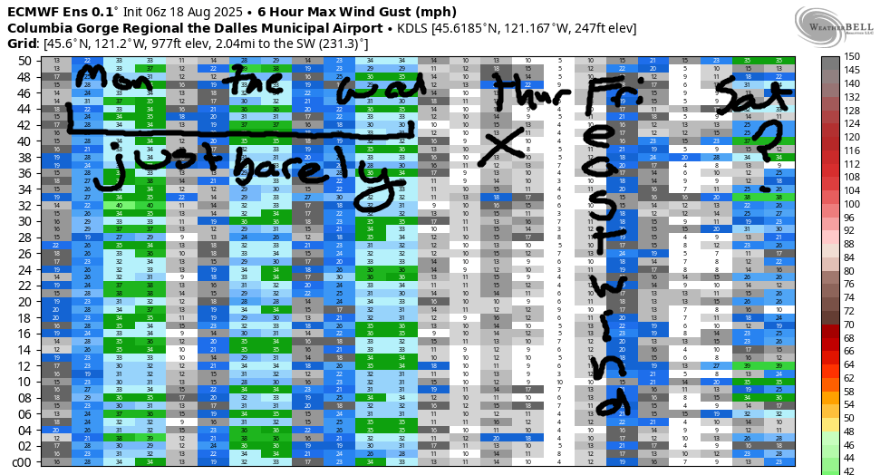
Hi friends! Moderate, probably-just-enough, westerlies stick around Monday through Wednesday as cool air aloft and offshore low pressure combine to squash gradients. Heat surges north from the desert southwest starting Thursday. Unfortunately, both side of the cascades will be infiltrated by the heat. This results in light wind on Thursday and easterlies Friday. After that: we wait for the cooldown. Gorge wind forecast ensembles are all over the place on when this will happen and how intense it will be. For example, yesterday’s deterministic GFS had 30-35mph on Sunday. Now it does not, but it has 27-30mph on Monday. Ensembles aren’t much help here – they’re all over the place too. Patience… fingers crossed that this ends up being “The Cooldown You Were Looking For”!
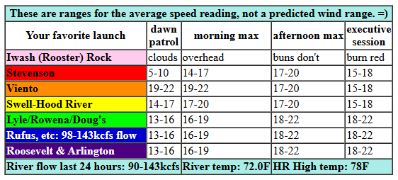
In the meantime… Monday started with pressures of 30.01/29.96/29.94 for gradients of 0.05 (PDX-DLS) / 0.02 (DLS-PSC). Wind was 14-17mph between Viento and Hood River with 10-13mph at Stevenson, the Rowena zone, and the Rufus zone. We’re expecting most of these clouds to burn off today, but a few low clouds will linger on the west wide. This gives us a slow build to 16-19mph late morning or early afternoon from Swell to Rufus with 13-16mph at Stevenson and Arlington. Afternoon wind rises to 19-22mph from Mosier to Arlington and drops to 15-18mph between Stevenson and Hood River. River flow over the last 24 hours was 90-143kcfs, river temp is 72.0F, and high temp forecast is 78F with clearing sky.
RIVER FLOW FOR SITES BETWEEN AVERY (EAST OF THE DALLES) AND RUFUS: CLICK HERE FOR JOHN DAY DAM FLOW.
RIVER FLOW FOR SITES BETWEEN STEVENSON AND DOUG’S BEACH (WEST OF THE DALLES): CLICK HERE FOR THE DALLES DAM FLOW

tomorrow’s gorge wind forecast
Clear sky is forecast on Tuesday until the afternoon, when a weak system sends high clouds into the Gorge. This system nudges the wind upwards by keeping the west side cooler than the east. Early wind will be 11-14mph from Viento to Swell. Late morning: 16-19mph from Stevenson to The Dalles. As the system exerts influence mid afternoon, Stevenson-Hood River drop to 15-18mph and Mosier-Avery rises to 20-23mph. Late in the day, just in time for the Executive Session (after 5pm), westerlies rise to 22-25mph from Mosier to Rufus. High temp: 82F.
extended Gorge wind forecast
Offshore high pressure returns on Wednesday. Low clouds are forecast in the metro area early with sunshine later. Current forecast (subject to change a bit as usual this far out) is 18-21mph from Viento to Swell early with 18-21mph from Stevenson to Doug’s in the afternoon. If the low clouds over-perform, we could see a few mph more than this forecast. High temp: 81F for Hood River.
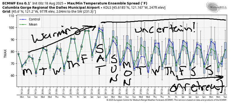
Heat surges north from Arizona on Thursday. Models currently have 10-13mph to start and less later. On Friday, the hottest weather sets up over the Willamette Valley. This turns the wind easterly. For now, let’s say 20mph and re-evaluate when the high-resolution models for Friday speak up in a couple days. Saturday looks hot with light/variable wind. Models, as I mentioned at the start of this forecast, are all over the place on the timing of the cooldown. That said, most ensembles have west wind of some sort Sunday through all of next week. Speaking of next week, I leave the 29th for a week of meditation. That’s almost certain to guarantee a week of strong west wind! See you on the Nch’i Wana!
Was that helpful? I knew it was! Guess what? All of this crucial work – from your personal wind and snow reports to the invaluable TATAS updates – is made possible by my relentless efforts. Maintaining this labor of love isn’t easy. Each daily forecast takes hours. Website hosting, weather model access, and back-end admin work takes time and money. That’s where you come in.
YOUR CONTRIBUTION MAKES A DIFFERENCE
- SUPPORT ACCURATE, HYPER-LOCAL WEATHER FORECASTING
- ENABLE ACCESS FOR ALL, EVEN THOSE WITH LESS MEANS
- SUPPORT A COOL HUMAN WHO WORKS HARD SO YOU CAN PLAY
Take a moment to click one of the buttons below. Donate $19.99 or more (how much does this forecast enhance your life?) and get the email in your inbox. Whether it’s a renewing subscription (auto-renew) or a one-time donation, every contribution makes a real difference. Help me keep this labor of love alive, so we can all continue playing, commuting, and living in the Gorge with peace of mind and the best weather forecasts possible. Thank you!


Hood River, Oregon 97031


JONES BEACH, SAUVIE ISLAND, & COAST FORECAST
Wind northerly unless otherwise indicated. For coast, it’s North/Central/South with the “central” at approximately Florence. Swell forecast from NWS for central coast. Jones: westerly unless otherwise stated. Sauvie Island: northerly unless otherwise stated. Coast Monday: LTW/LTW/LTV, NW swell 5′ at 9 seconds. Tuesday: LTNW/NW5-10/N15-20, NW 4′ @ 9. Wednesday: 15-20/20/25-30, NW 4′ @ 15. Jones Monday: 11-14. Tuesday: 14-17. Wednesday: 16-19. Sauvie Island Monday: 8-11 > 5pm. Tuesday: 8-11. Wednesday: 12-15.
BARE BONES HOOD RIVER WEATHER FORECAST
Mostly cloudy sky this morning. Partly cloudy later. Temps start in the mid 60s and rise to the upper 70s. Moderate westerlies. No rainbows. Tuesday will be sunny most of the day with high clouds late. Temps start in the mid 50s and rise to the low 80s. Moderate westerlies. No rainbows. Wednesday will be partly cloudy then clear. Temps start in the upper 50s and rise to the low 80s. Moderate westerlies. No rainbows.
TEMIRA’S AWESOME TRAVEL ADVISORY SERVICE – MONDAY 8/18
HYPERLOCAL WEATHER FORECAST FOR THE COLUMBIA GORGE
THE DALLES, HOOD RIVER, WHITE SALMON, TROUT LAKE, STEVENSON, CASCADE LOCKS, PARKDALE, ODELL, HUSUM, BZ, MILL A, WILLARD, GOLDENDALE, RUFUS, ARLINGTON, boardman
Good morning, neighbors. Cool weather. Hot weather. Windy weather. That’s the plan for the next seven days or so. Mornings will be warm most places. Did you know that average lows in Hood River this time of year are 50-53F degrees? Not the 60+ degrees we’ve been seeing most days?
glenwood this morning
Looking at Glenwood’s low temps today, we see a warm morning for Glenwood: 54 degrees. As it’s Monday, everyone in Glenwood who works a desk job is getting ready for work. Everyone else is putting on chaps. Because they haven’t had coffee yet, they all forgot pants and panties under the chaps, so their junk is hanging out. SEXY!
today’s gorge weather forecast
The rest of us started with a rather warmish morning: 57-71 degrees, Rowena being the overachiever this morning along with Wyeth. Our widespread morning clouds eventually (mostly) burn off, but they’ll be nice to have this morning! Get outside and do some outside stuff! West wind builds to 15-20mph by early afternoon between Stevenson and Rufus with the Arlington Equilateral Triangle joining in late afternoon. Highs range from 78F (west) to 82F (Dallesport – you thought I was going to say “The Dalles”, didnt’ you?) and 90F (desert, where the Bighorn sheep are glad they haven’t been shorn).
Oh hey, a quail just landed on my fence 10 feet away and is calling his friends!
tuesday’s gorge weather forecast
Tuesday looks like a sunny day. In the evening, high clouds arrive, and this makes for a pretty sunset. Morning temps will be 55-60F (ish). Afternoon brings low 80s to the west, upper 80s to Fred Meyer, and 91F in the desert. Wind will be 10-15mph from Viento to Hood River early. Afternoon wind rises to 20mph west of Mosier, and 20-25mph from Mosier to Rufus.
wednesday’s gorge weather forecast
A few low clouds on the west side Wednesday give way to mostly clear sky in the afternoon. Highs range from 80F in the west to 90F in The Dalles and the desert. Wind will be 15-20mph from Viento to Hood River to start with 15-20mph from Stevenson to The Dalles in the evening.
thursday’s gorge weather forecast
Hotter, not-windy weather is forecast on Thursday, when The Dalles maxes out at 94F or so. East wind, perhaps 20mph near Stevenson, is forecast for Friday. This is important, because it’ll be hot, low-humidity, and blowing easterly even up in the hills. Saturday looks hot and calm: temps are headed for 95F on the west side and 100F from The Dalles eastward. If that temp gradient plays out, it won’t actually be calm – we’ll see west wind return late in the day and (slightly) cool things off. It’ll be more like a convection over (I need to turn mine on (NOT LIKE THAT – just the electricity, not the oven’s libido) so I can break bread for my BLT & Tomato Tasting Gathering tonight)….
extended gorge weather forecast
Ohhhhh, one of the big baby quail just joined on the fence! SO CUTE! (I would post a picture, but I took one and it’s really unclear because my windows are so dirty – now I’m going to wash them today!)
Back to the weather… We start to cool off a bit sometime between late Saturday and Monday or Tuesday. Looking at next week, models are all over the place. Some hold on to a hotter/ridging pattern. Some bring in troughing and cooler weather. If you’re my friend, you’ll vote for the latter because it’s 1) cooler and 2) windier.
The baby quail is singing now too!
Safe travels. -TATAS
HEY! DON’T STOP READING! Is this community-focused forecast helpful to you? It sure is! It takes me a couple hours a day to write. Please join your friends and neighbors in contributing to keep it going. Venmo: @thegorgeismygym PayPal: twomirrors@gmail.com USPS: Temira / PO Box 841 / Hood River, Oregon 97031 You can test out the forecast subscription for a few days for free by signing up below. Easy! Do it!
