

GORGE WIND FORECAST
If you’re still seeing yesterday’s and it’s after 9am, try opening this in an incognito window
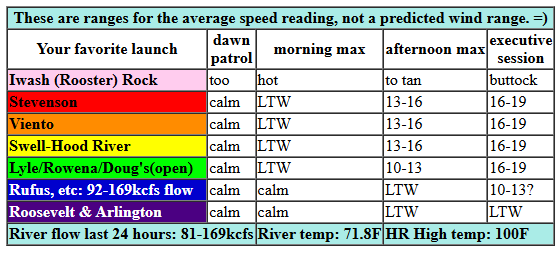
today’s gorge wind forecast
Hi friends! Thanks for letting me take a day off yesterday! I didn’t get All The Things done, but it was still nice to have a couple extra hours in the morning. I’ll be here for you daily now until I head off on retreat for 6 days starting Labor Day weekend. Between now and then… westerlies return today and really ramp up on Wednesday. When I last looked at the models (Saturday), all looked good for the end of next week and next weekend. But now… now we have an atmospheric river with high potential for cool temps and rain all the way into the desert starting Friday. Almost all the ensemble members have wind every day through Sunday (at least), but they’ve knocked down the strength beyond Thursday. Let’s take a look, shall we?
Today (Monday) started off with pressures of 29.99/29.97/29.97 for not much gradient and excellent fishing weather. I see lots of boats at the mouth of the White Salmon! Westerlies take their time today; we’ll be under 10mph this morning. By mid-afternoon, the wind builds as the ridge shifts westward and allows (slight) cooling in the west side and blasting heat out in the desert. We’ll see a slow build to 16-19mph between Stevenson and Mosier this evening with 13-16mph from Lyle to Doug’s. Worth mentioning: breaking out of the heat wave can happen more slowly than expected, and usually does. I won’t be surprised if the wind is lighter than this forecast. River flow over the last 24 hours was 81-169kcfs, river temp is 71.8F (poor salmon), and high temp forecast is 100F for Hood River.
RIVER FLOW FOR SITES BETWEEN AVERY (EAST OF THE DALLES) AND RUFUS: CLICK HERE FOR JOHN DAY DAM FLOW.
RIVER FLOW FOR SITES BETWEEN STEVENSON AND DOUG’S BEACH (WEST OF THE DALLES): CLICK HERE FOR THE DALLES DAM FLOW

tomorrow’s gorge wind forecast
While it’ll still be hot in the metro area on Tuesday, it won’t be as hot, and the desert will still be baking like a rattlesnake on a rock at Syncline. The day starts with 17-20mph from Viento to the Hatch. Midday wind rises to 17-20mph from Stevenson to Doug’s. As a trough slides south from BC, instability knocks down the wind at the Hatch and shifts things east: 20-23mph from Mosier to Rufus and 13-16mph at Arlington. Rufus may over-perform if the wind aloft provides a little extra support. High temp: 97F for Hood River and 102F out in the desert with a few afternoon mid and high clouds.
extended Gorge wind forecast
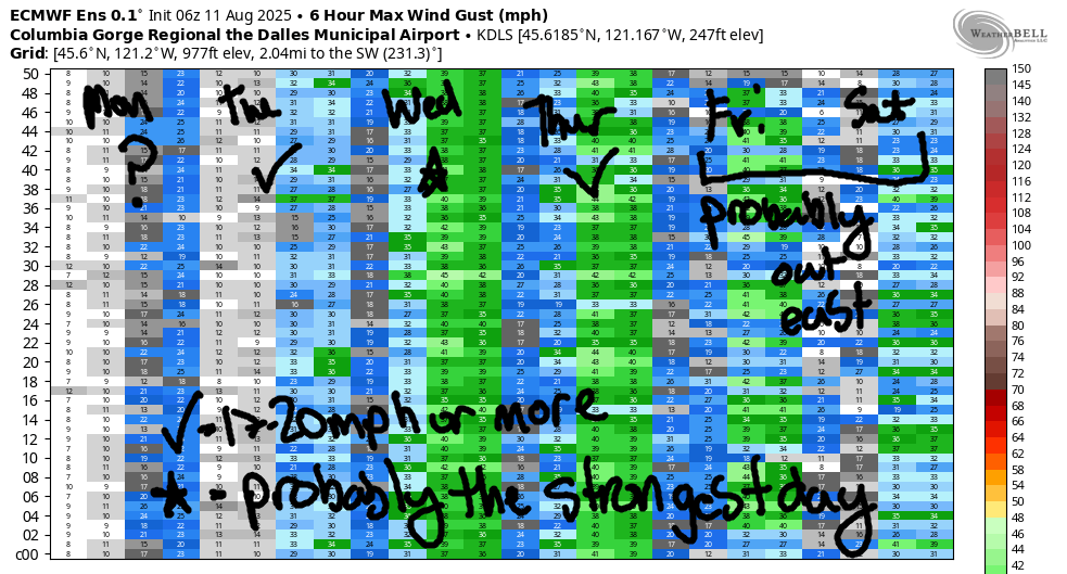
Troughing sets up along the west side on Wednesday, high pressure holds west of it in the Pacific, and the heat low lingers in the desert. It’s going to be a windy one! Both the GFS and the Euro have backed off on the marine layer, but they haven’t backed off on the wind at the Hatch: 22-25mph to start and 27-30mph (+) in the afternoon. The GFS takes Mosier-Boardman to 30-35mph in the afternoon, but I’m skeptical of the far-east forecast given that the Euro ensembles don’t agree on that level of nuking. My schedule has been cleared. Join me in clearing yours if you can. High temp: 82F for Hood River, upper 80s to low 90s out east.
Models call for a deep marine layer on Thursday, which would shift the wind out east. An approaching front disrupts the wind field. For now, let’s call it gusty 25-28mph and revisit it each day. Up next: Friday and Saturday: it’s almost certainly going to rain! Models are all over the place on wind speeds. Given the massive available moisture and fronts forecast to move in, the wind will almost certainly be east of The Dalles and gusty. That’s a big change from the last forecast I wrote, eh? Hopefully you don’t have to change plans that you made. We’ll keep a very close eye on this incoming “weather”. And you should clear your Wednesday. See you on the Nch’i Wana!
Was that helpful? I knew it was! Guess what? All of this crucial work – from your personal wind and snow reports to the invaluable TATAS updates – is made possible by my relentless efforts. Maintaining this labor of love isn’t easy. Each daily forecast takes hours. Website hosting, weather model access, and back-end admin work takes time and money. That’s where you come in.
YOUR CONTRIBUTION MAKES A DIFFERENCE
- SUPPORT ACCURATE, HYPER-LOCAL WEATHER FORECASTING
- ENABLE ACCESS FOR ALL, EVEN THOSE WITH LESS MEANS
- SUPPORT A COOL HUMAN WHO WORKS HARD SO YOU CAN PLAY
Take a moment to click one of the buttons below. Donate $19.99 or more (how much does this forecast enhance your life?) and get the email in your inbox. Whether it’s a renewing subscription (auto-renew) or a one-time donation, every contribution makes a real difference. Help me keep this labor of love alive, so we can all continue playing, commuting, and living in the Gorge with peace of mind and the best weather forecasts possible. Thank you!


Hood River, Oregon 97031


JONES BEACH, SAUVIE ISLAND, & COAST FORECAST
Wind northerly unless otherwise indicated. For coast, it’s North/Central/South with the “central” at approximately Florence. Swell forecast from NWS for central coast. Jones: westerly unless otherwise stated. Sauvie Island: northerly unless otherwise stated. Coast Monday: NW15/N10-15/N15-20, NW swell 7′ at 10 seconds and SW 2′ at 17 seconds. Tuesday: W10-15/15/20-25, NW 7′ @ 10 and SW 2′ @ 16. Wednesday: LTNW/NNW5-10/N25-30, NW 7′ @ 9 and SW 3′ @ 15. Jones Monday: 12-15. Tuesday: 19-22. Wednesday: LTW. Sauvie Island Monday: 9-12. Tuesday: 10-13. Wednesday: NNW 15-18.
BARE BONES HOOD RIVER WEATHER FORECAST
Clear and hot today. Temps start in the low 60s (open windows) and climb to 100. Calm wind in the morning. Light to moderate westerlies later. No rainbows. Tuesday will be sunny with a few clouds in the afternoon. Temps start in the upper 60s and rise to the upper 90s. Moderate westerlies. No rainbows. Wednesday will be mostly clear. Temps start in the upper 80s and rise to the mid 90s. Strong westerlies. No rainbows.
TEMIRA’S AWESOME TRAVEL ADVISORY SERVICE
HYPERLOCAL WEATHER FORECAST FOR THE COLUMBIA GORGE
THE DALLES, HOOD RIVER, WHITE SALMON, TROUT LAKE, STEVENSON, CASCADE LOCKS, PARKDALE, ODELL, HUSUM, BZ, MILL A, WILLARD, GOLDENDALE, RUFUS, ARLINGTON, boardman
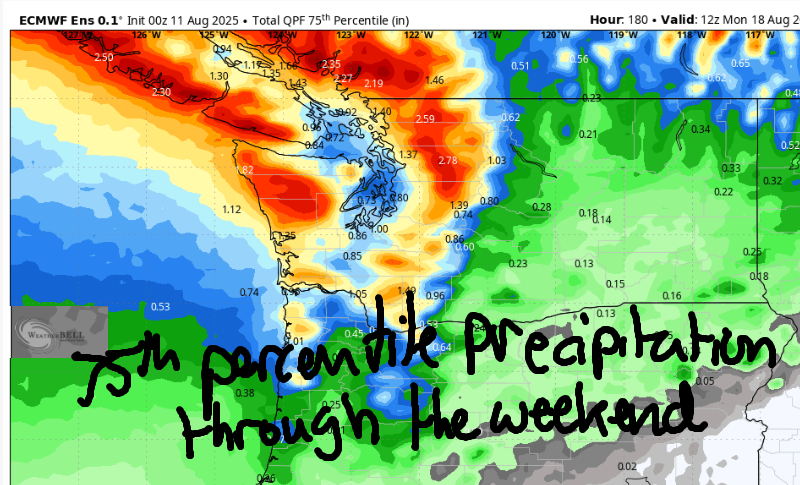
Good morning, neighbors! Oh my gosh – all sorts of interesting stuff to talk about today. And I have more energy to do it after taking a day off yesterday. Here’s what we’ve got: triple-digit heat for most of us today and for many of us tomorrow. Super windy weather on Wednesday. Darn good chances of rain (way more moisture involved than last time) for Friday and Saturday. Yup, you read that right. RAIN! Maybe even record rain, and almost certainly record available moisture. Take a look at the image of the 75th percentile for precipitation through the weekend.* Not bad! (*I chose 75th because there’s SO MUCH availble moisture)
glenwood this morning
But none of that happens today. It’s Monday, and it’s going to be hot as a lizard fucking another lizard in Death Valley in early August. After a reasonable start – 50 degrees in Glenwood, where all the cowboys are oiling their chaps – temps rise to 100-105 degrees. We missed a record in Hood River yesterday by 1 measly degree. Today’s record is 105. We are unlikely to break that. Calm wind this morning (GREAT for fishing) picks up to 10-15mph mid-afternoon (Stevenson-Mosier) and 15-20mph this evening (Stevenson-Murdoch).
Tuesday Gorge weather forecast
Tonight’s gonna be a warm one near the Nch’i Wana (Columbia River) thanks to a westerly breeze: it might be warm enough to set a record high-low tomorrow (Tuesday). That record is 65 degrees and likely to fall. For the rest of Tuesday: lots of heat, lots of sun, and a few afternoon clouds. Temps max out in the upper 90s (west) and low triple digits (The Dalles eastward to the watermelon zone). West wind will be 15-20mph all day from Viento to Hood River with 20-25mph from Mosier to Rufus in the afternoon and 10-15mph at the Arlington Bermuda Triangle Pose, the area more easily known as “Roosevelt, WA”.
wednesday gorge weather forecast
Much cooler weather is forecast for the west side on Wednesday, but the desert will still be in the mid to upper 90s. If you know the Gorge, you know what that means: blasting west wind. DO NOT START A FIRE. Temps in the morning start in the upper 60s (hot, maybe record hot). Afternoon brings low 80s to the west side, 90 in The Dalles, and 96 out near the fields of watermelons. Just how strong will the wind be? 20-25mph in the morning picking up to 30-35mph (average speed) in the afternoon all the way from Stevenson to Boardman.
extended gorge weather forecast
Much cooler weather is forecast Thursday into the weekend. Things get very interesting on Friday as a potentially record-breaking (I think, anyway) atmospheric river potentially takes direct aim at us. A couple of fronts combine with decently-strong (technical term there) wind aloft to squeeze the moisture out of this sponge. Given the available moisture in the column – upwards of 1.25” – significant rain is not only possible, it’s likely. Timing isn’t quite set, but many of us (probably as far east as The Dalles if nothing changes) can count on a cool and cloudy and probably wet period to end this week.
Do you hear that sound? That’s the sound of chanterelle mycelium stretching into the future to touch the rain in the forecast. And do you hear that other sound? That’s my heart (and stomach) getting very excited to eat the fruits of the mycelium. Safe travels. -TATAS
HEY! DON’T STOP READING! Is this community-focused forecast helpful to you? It sure is! It takes me a couple hours a day to write. Please join your friends and neighbors in contributing to keep it going. Venmo: @thegorgeismygym PayPal: twomirrors@gmail.com USPS: Temira / PO Box 841 / Hood River, Oregon 97031 You can test out the forecast subscription for a few days for free by signing up below. Easy! Do it!
