

GORGE WIND FORECAST
If you’re still seeing yesterday’s and it’s after 9am, try opening this in an incognito window
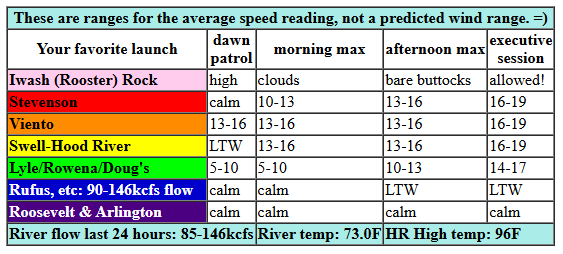
today’s gorge wind forecast
Hi friends! Yesterday we saw how unpredictable and changeable the wind models can be from day to day and even from run to run. The night-before model run had east wind for yesterday, and then reality gave us 14-17mph westerlies! Yesterday’s westerlies are a good sign for today and the rest of the week – we saw the heat low shift east yesterday, and we’ll have onshore gradients again today. Uncertainty remains quite high this week, so be cautious about using ink to write down your plans.
Monday started with pressures of 29.92/29.88/29.89 for gradients of W 0.04 and E 0.01. Models suggest some wind this morning, a dip midday, and slightly stronger wind this evening. If the models are correct, we’ll see a period of 16-19mph from Stevenson to Swell mid-morning (12-15mph in Hood River) followed by a dip to 13-16mph (Stevenson-Swell) midday. The wind languishes in that range until the evening, when it returns at 16-19mph from Stevenson to Hood River and 12-15mph near Mosier. To the east, the wind will be light all day, under 10mph. River flow over the last 24 hours was 85-146kcfs, river temp is 73.0F (poor salmon!), and high temp forecast is 96F. One note: instability will be present along the Cascade Crest, and that will impact wind quality and quantity.
RIVER FLOW FOR SITES BETWEEN AVERY (EAST OF THE DALLES) AND RUFUS: CLICK HERE FOR JOHN DAY DAM FLOW.
RIVER FLOW FOR SITES BETWEEN STEVENSON AND DOUG’S BEACH (WEST OF THE DALLES): CLICK HERE FOR THE DALLES DAM FLOW

tomorrow’s gorge wind forecast
Tuesday looks similar in strength to Monday. Instability persists. Instability impacts wind quality. Models hint at 17-20mph dawn patrol from Viento to Swell followed by a quick drop to 13-16mph (Stevenson to Swell). In the afternoon, westerlies return at 16-19mph between Stevenson and Mosier. A couple mph more are possible in the evening (for the Executive Session), and it’s also possible the 16-19mph wind will spread as far east as The Dalles. Models do hint at evening instability potentially driving the wind speed below 15mph in the evening west of Mosier. High temp: 93F.
extended Gorge wind forecast
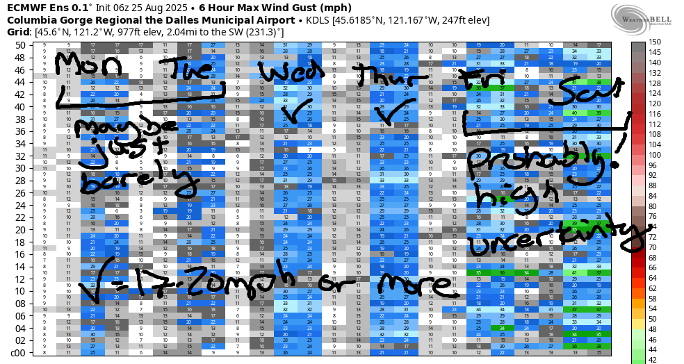
Models have no idea what will happen on Wednesday. Looking at the Euro ensemble, we’ve got 19-22mph out east with the potential for stronger wind near Hood River. The GFS deterministic insists on 30+ mph out east in the afternoon; there is ZERO sign of this in the Euro ensembles. Add widespread atmospheric instability to this picture, and we have a very low confidence forecast at this point. Let’s just say there will be 17-20mph+ somewhere and refine as we get closer. Hopefully the models will start to form a consensus. High temp: 87F.
Instability decreases starting Thursday, which will improve wind quality. Disagreement continues between the Euro and deterministic GFS; 20mph or more seems likely. Uncertainty really increases as we move into the weekend and the overall pattern becomes less certain. Part of this is due to the likelihood of a low pressure system (and cooler air, yay) settling in off the coast. Various associated factors combine to create uncertainty. That said, about 80% of the ensemble members have 17-20mph+ for Friday, Saturday, Sunday, and potentially beyond. I’ll get a forecast out Friday morning, and then I’ll be on retreat until the following Thursday. That, of course, means it will be windy every day! Hope to see you on the Nch’i Wana today!
Was that helpful? I knew it was! Guess what? All of this crucial work – from your personal wind and snow reports to the invaluable TATAS updates – is made possible by my relentless efforts. Maintaining this labor of love isn’t easy. Each daily forecast takes hours. Website hosting, weather model access, and back-end admin work takes time and money. That’s where you come in.
YOUR CONTRIBUTION MAKES A DIFFERENCE
- SUPPORT ACCURATE, HYPER-LOCAL WEATHER FORECASTING
- ENABLE ACCESS FOR ALL, EVEN THOSE WITH LESS MEANS
- SUPPORT A COOL HUMAN WHO WORKS HARD SO YOU CAN PLAY
Take a moment to click one of the buttons below. Donate $19.99 or more (how much does this forecast enhance your life?) and get the email in your inbox. Whether it’s a renewing subscription (auto-renew) or a one-time donation, every contribution makes a real difference. Help me keep this labor of love alive, so we can all continue playing, commuting, and living in the Gorge with peace of mind and the best weather forecasts possible. Thank you!


Hood River, Oregon 97031


JONES BEACH, SAUVIE ISLAND, & COAST FORECAST
Wind northerly unless otherwise indicated. For coast, it’s North/Central/South with the “central” at approximately Florence. Swell forecast from NWS for central coast. Jones: westerly unless otherwise stated. Sauvie Island: northerly unless otherwise stated. Coast Monday: NW5-10/N10-15/N25-30, NW swell 5′ at 8 seconds. Tuesday: NNW10-15/NNW15/N25, NW 5′ @ 8. Wednesday: NW10/NNW10/N10, NW 4′ @ 8. Jones Monday: 18-22. Tuesday: 23-26. Wednesday: 16-19. Sauvie Island Monday: 10-13 > 5pm. Tuesday: 13-16 > 5pm. Wednesday: 7-10.
BARE BONES HOOD RIVER WEATHER FORECAST
Partly high overcast this morning. Temps start in the mid 60s and rise to the mid 90s. Muggy. Moderate westerlies. No rainbows. Tuesday will be partly cloudy with a chance of thunder. Temps start in the upper 60s and rise to the low 90s. Muggy. Moderate westerlies. 1.5% chance of rainbows. Wednesday will be mostly clear. Temps start in the upper 60s and rise to the upper 80s. Moderately strong westerlies (???). 2% chance of rainbows.
TEMIRA’S AWESOME TRAVEL ADVISORY SERVICE
HYPERLOCAL WEATHER FORECAST FOR THE COLUMBIA GORGE
THE DALLES, HOOD RIVER, WHITE SALMON, TROUT LAKE, STEVENSON, CASCADE LOCKS, PARKDALE, ODELL, HUSUM, BZ, MILL A, WILLARD, GOLDENDALE, RUFUS, ARLINGTON, boardman
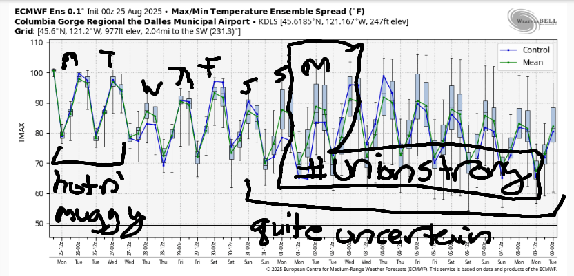
Good morning, neighbors! Hot, muggy weather continues… today will be the hottest of the days, and then we’ll slowly cool down a bit. Still… models are not optimistic about The Dalles dropping below 90 degrees any time soon. Model uncertainty increases Saturday and continues into next week (when I’ll be meditating and won’t really care so much about the weather from day to day). Our next chance of rain comes from atmospheric instability over the next few days, but the chance of a widespread, soaking rain is quite low.
Glenwood, WA this morning
It’s another very warm morning here in the Gorge: 60-70F degrees for most of us with 75F on Middle Mountain and a few scattered upper 50s. Once again, if you want to sleep well, you should be spending the night in Glenwood: they started the day at 51F. Being filled with wisdom, the beings of Glenwood never forget to practice gratitude for the cool morning temps. By doing so, they create minds that feel gracious and thankful more often than not. You too can try this by practice gratitude each morning. I do this. Every morning I thank the sun for coming up so I didn’t freeze into a block of ice, and I also thank it for not going supernova and burning me to a crisp. No really. I do this. It’s very grounding and fills my heart with gratitude! It’s the simple things…
Monday’s Gorge weather forecast
Moving on to Monday’s weather… it’s going to be a hot and muggy one. If you’re out and about today, drink plenty of water and reframe the situation as a free Hot Yoga class. Temps max out around 96F (Hood River) and 100F (The Dalles and areas to the east). Up in the hills: quite warm as well thanks to 850mb temps pushing 25C. Monsoonal moisture streaming in from the south allows mid and high level clouds to build this afternoon. It’s possible we’ll see temps under-perform today. That would be nice! West wind builds to 15mph or so between Stevenson and Hood River this afternoon. To the east: the wind stays light. It’s really worth highlighting the mugginess today: some areas will have a dewpoint as high as 62F this afternoon! Wow! But that’s nothin’ compared to Tuesday…
Tuesday’s Gorge weather forecast
A muggy, hot (upper 60s) Tuesday morning leads into a muggy, hot Tuesday day and Tuesday afternoon and Tuesday night. We’ll have a slight chance of showers and/or thundershowers along the Cascade Crest. West wind will be 15-10mph in the morning between Viento and Hood River. It’ll bounce around during the day and eventually spread east to The Dalles. Most interesting thing on Tuesday: models have the dewpoint at high as 67 degrees midday near The Dalles. This is crazy-pants muggy for this region. Your pants will be crazy-sweaty-stuck-to-you. High temps range from the low 90s (west) to 100-102 (The Dalles and areas to the east). If we get lucky, cloud cover will inhibit the heat a bit.
Wednesday’s Gorge weather forecast AND the future of this nation
Somewhat cooler weather is forecast on Wednesday, but we’ll still start hot (upper 60s) and we’ll still be muggy (dewpoint 55-60F). While highs will be down – upper 80s to the west and low 90s to the east – it’ll still be hot. And muggy. Wind forecast models are all over the place. For now, let’s call it 20-25mph between Stevenson and Arlington with the potential for stronger wind east of The Dalles. We are seriously like the frog in the pot of warming water here. Kinda like we are in this nation – the water just gets hotter and hotter. First we have masked goons refusing to show identification and picking up people (documented and not) off the streets and at the borders and locking them up. Next we have unarmed military in the streets. Next we have armed military in the streets. You might not be noticing this because it’s happening bit by bit and isn’t happening to YOU specificically. THIS IS NOT NORMAL. We do not have military in the streets in this country. You should be concerned, whatever political affliliation you hold.
First they came for the non-binary people (1/20/2025), and you were not non-binary, so you didn’t say anything. Then they came for the immigrants, and you did not say anyting because you are a citizen. Then they came for the tourists at the borders, and you did not say anything because you live here. Then they came for the liberal cities with the military, but you did not speak up because you’re in rural America. What will it take for you to sspeak up and stand up? Who will they have to come for before you let your outrage and worry and patriotism move you to action?
Extended Gorge weather forecast
Think about this as you consider what to do for the latter half of the week. Weather-wise, similar conditions – warm, breezy – are forecast through Saturday, although uncertainty ramps up starting Friday. By Sunday, there’s a 15+ degree spread in possible high temps. That continues into next week. So don’t be trusting your phone weather forecasts, okay? Safe travels. -TATAS
HEY! DON’T STOP READING! Is this community-focused forecast helpful to you? It sure is! It takes me a couple hours a day to write. Please join your friends and neighbors in contributing to keep it going. Venmo: @thegorgeismygym PayPal: twomirrors@gmail.com USPS: Temira / PO Box 841 / Hood River, Oregon 97031 You can test out the forecast subscription for a few days for free by signing up below. Easy! Do it!
MT HOOD SNOW FORECAST

CURRENTLY ON VACATION. WILL RETURN SOMETIME BEFORE THE START OF SKI SEASON AT MEADOWS, TIMBERLINE AND SKIBOWL. SAME GOES FOR THE NORDIC SKIING SEASON AT MEADOWS AND TEACUP!
