

GORGE WIND FORECAST
today’s gorge wind forecast
Hi friends! Welcome to another summer day in the Gorge. We’ll be right on the edge (again) today for just enough wind to get some of you on the water. Stronger westerlies return Tuesday and Wednesday as the hottest weather in the region shifts east of the Cascade Crest. Westerlies continue into Thursday, Friday’s a question mark, and the Gorge wind forecast beyond that is an even bigger question mark as models struggle for consensus on the overall weather picture.
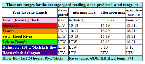
Looking at Monday, it’s, well, it’s a Monday. Pressures early this morning were 30.01/29.97/29.98 for gradients of 0.04 (PDX-DLS) and E 0.01 (DLS-PSC). That setup says “Corridor or Nothing”, and nothing it is to start the day. The iWind/iKite Viento sensor was reading 13mph early, and everywhere else was at 0-10mph. We’ll see a slow build into the afternoon as we await support from the cross-Cascade thermal gradient. It’ll be strongest after the metro area starts to cool in the evening. So… midday wind rises to 11-14mph from Stevenson to Hood River. Afternoon: 16-19 from Stevenson to Mosier with 12-15 from Lyle to Rowena. If everything plays out just right this evening, we could see 18-21mph from Stevenson to Doug’s. East of Doug’s, the wind will be light all day. River flow over the last 24 hours was 95-175kcfs, river temp is 68.0F, and high temp forecast is 94F for Hood River.
RIVER FLOW FOR SITES BETWEEN AVERY (EAST OF THE DALLES) AND RUFUS: CLICK HERE FOR JOHN DAY DAM FLOW.
RIVER FLOW FOR SITES BETWEEN STEVENSON AND DOUG’S BEACH (WEST OF THE DALLES): CLICK HERE FOR THE DALLES DAM FLOW

tomorrow’s gorge wind forecast
The ridge of high pressure and associated extra-hot temps shifts east of the Cascades on Tuesday. Offshore, a weak system with cooler air approaches the coast. This sets us up for a bangin’ (is that a good use of that word) cross-Cascade thermal gradient (helpful) and instability east of the Cascades (definitely not helpful). It’s also worth noting that marine clouds will be absent, a setup that often leads to the wind at the Hatch falling apart.
So. Dawn Patrol looks like 22-25 from Stevenson to Swell with 19-22 from Hood River to Mosier and 12-15 east of Mosier to Arlington. The wind dips to 19-22 near Swell mid-morning. Afternoon wind is forecast to build, but instability could be a problem, especially east of The Dalles. All that said… we should see 23-26 from Stevenson to Doug’s (exception: Hatch) by early afternoon with 11-14 at Avery. The Hatch, thanks to the heating metro area, is questionable and may be super-gusty and under-performing. From mid-afternoon on, as that thermal gradient really establishes itself, westerlies are forecast to rise to gusty 27-30 from Mosier to Rufus and then to Arlington for the late-day session. With instability present, I’m a bit skeptical of both the strength and wind quality. High temp: 92F for Hood River and 98F at Arlington.
extended Gorge wind forecast
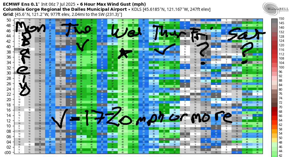
A big marine cloud push is forecast on Wednesday morning. Those clouds keep pushing inland during the day, which makes the eastern Gorge the place to be. As of now (subject to change), Wednesday looks like this: 18-21 from Stevenson to Arlington to start. By late morning: gusty 19-22 (and at least partly cloudy) from Stevenson to Mosier with 25-28 from Lyle to Rufus. Afternoon wind rises to 29-33 from Lyle to Arlington with 23-26 from Threemile to Boardman. Wind west of Lyle really depends on what the clouds do; as of now, the afternoon forecast is for very gusty, very up-and-down, 20-26. Let’s refine this as we get closer. High temp: 79F and partly to mostly cloudy in Hood River with 85F and sunshine out east.
Thursday’s forecast has quite a bit of range in it still. For now, let’s say 21-24 from Stevenson to Doug’s with high temps around 80. Model agreement falls apart on Friday; it will be hotter on Friday, but it’s unclear what the wind will do. Beyond that, uncertainty is quite high, high enough that making a prediction for next weekend remains impossible. Let’s check in about that again tomorrow morning, shall we? Have a great day today. Stay cool whatever you do!
Was that helpful? I knew it was! Guess what? All of this crucial work – from your personal wind and snow reports to the invaluable TATAS updates – is made possible by my relentless efforts. Maintaining this labor of love isn’t easy. Each daily forecast takes hours. Website hosting, weather model access, and back-end admin work takes time and money. That’s where you come in.
YOUR CONTRIBUTION MAKES A DIFFERENCE
- SUPPORT ACCURATE, HYPER-LOCAL WEATHER FORECASTING
- ENABLE ACCESS FOR ALL, EVEN THOSE WITH LESS MEANS
- SUPPORT A COOL HUMAN WHO WORKS HARD SO YOU CAN PLAY
Take a moment to click one of the buttons below. Donate $19.99 or more (how much does this forecast enhance your life?) and get the email in your inbox. Whether it’s a renewing subscription (auto-renew) or a one-time donation, every contribution makes a real difference. Help me keep this labor of love alive, so we can all continue playing, commuting, and living in the Gorge with peace of mind and the best weather forecasts possible. Thank you!


Hood River, Oregon 97031


JONES BEACH, SAUVIE ISLAND, & COAST FORECAST
Wind northerly unless otherwise indicated. For coast, it’s North/Central/South with the “central” at approximately Florence. Swell forecast from NWS for central coast. Jones: westerly unless otherwise stated. Sauvie Island: northerly unless otherwise stated. Coast Monday: 20/20-25/25, NW swell 4′ at 7 seconds. Tuesday: W 5-10/NW5-10/LTS, W 3′ @ 8. Wednesday: LTW/LTW/N20, W 4′ @ 8. Jones Monday: 19-22. Tuesday: 21-24. Wednesday: LTW. Sauvie Island Monday: 12-15. Tuesday: 14-17. Wednesday: LTN.
BARE BONES HOOD RIVER WEATHER FORECAST
Sunshine all day Monday. Temps start in the upper 50s (open windows) and rise to the mid 90s (close windows). Light wind early. Moderate later. No rainbows. Tuesday will be sunny. Temps start in the low 60s and rise to the lo w90s. Moderately strong westerlies. No rainbows. Wednesday will be cloudy then partly cloudy. Temps start in the mid 60s and rise to the upper 70s. Moderate westerlies. No rainbows.
TEMIRA’S AWESOME TRAVEL ADVISORY SERVICE
HYPERLOCAL WEATHER FORECAST FOR THE COLUMBIA GORGE
THE DALLES, HOOD RIVER, WHITE SALMON, TROUT LAKE, STEVENSON, CASCADE LOCKS, PARKDALE, ODELL, HUSUM, BZ, MILL A, WILLARD, GOLDENDALE, RUFUS, ARLINGTON, boardman

Good morning, neighbors! Ma Nature’s taking us for a ride on the temperature roller coaster this week: hot for the next couple of days, cool Wednesday and Thursday, hot on Friday, and very, very uncertain from Saturday on through the extended forecast. Not likely: rain, other than a wee bit of mist Thursday in the NO-OR Cascades and perhaps areas in the Gorge west of Wyeth.
glenwood this morning
This morning in Glenwood, the day started sunny and 45 degrees. Everyone was driving around crashing into things because they were under the impression that turns at intersections were also supposed to be 45 degrees instead of 90 degrees. Glenwood folks, maybe wait until afternoon when the temps return to 90 degrees to attempt those corners.
everyone else in the Gorge today
For the rest of us, we started mostly in the upper 50s. And we’ll all be making 90 degree turns later. It’s gonna be hot in the city tonight: 94 degrees (west), 99 degrees (Dallesport), and 98 degrees (watermelon growing zones out east). Wind will be light early, which is why I’m trying to hurry up and get this done: it’s a great morning to spray fungicide! Westerlies pick up to 15-20mph between Stevenson and The Dalles this afternoon.
tuesday gorge weather forecast
Another hot, sunny day is forecast for Tuesday. Thanks to dewpoints in the low 50s, morning temps will be in the low 60s. MUGGY. Afternoon highs rise to 92 (west), 98 (Cherry Heights), and 104 (holy shit, that’s hot – watermelon zones). Westerlies will be 20-25mph in the morning from Stevenson to Mosier with 25-30 in the afternoon from Stevenson to the Arlington (equilateral) Triangle. Peeps, Tuesday is a bad day for the following activities: burn piles, fireworks, weed whacking, chainsaws, mowing, driving fence posts, and not having spark arrestors on your off-road vehicles. Carry water and a shovel and/or a fire extinguisher for extra safety or for the opportunity to be a hero. Ditto for Wednesday for spark-causing activities. Fire danger will be super high.
extended gorge weather forecast
Clouds push into the west side (story) on Wednesday. Thanks to the associated humidity, morning temps will be in the mid 60s. Afternoon: 79 (west), 85 (Smithville), and 94 (Crenshaw melon zone). West wind will be 20mph west of Lyle all day with 25-35mph from Lyle east to Boardman, where once again, those poor bored men are standing around with no opportunities to be manly. Thursday looks similarly warm but somewhat less breezy, and hopefully the bored men will find something to do.
Temps rebound like Angel Reese or Tina Charles on Friday. We’ll all finish the day a bit over 90 degrees. We might have some wind, and we might not. That maybe-maybe-not weather continues for the extended forecast; model uncertainty is high, as high as Irvin Rosenfeld, who holds the Guinness world record for “most marijuana consumed”, which, IMHO, is an unwise thing to have a competition around. But now we all know who holds that record, and lest you attempt to try it, know that as of 2014 he had consumed over 115,000 joints. Also know that Guinness has stopped accepted attempts at this record, as it might be detrimental to one’s health. Duh. Safe travels. -TATAS
HEY! DON’T STOP READING! Is this community-focused forecast helpful to you? It sure is! It takes me a couple hours a day to write. Please join your friends and neighbors in contributing to keep it going. Venmo: @thegorgeismygym PayPal: twomirrors@gmail.com USPS: Temira / PO Box 841 / Hood River, Oregon 97031 You can test out the forecast subscription for a few days for free by signing up below. Easy! Do it!
