

GORGE WIND FORECAST
If you’re still seeing yesterday’s and it’s after 9am, try opening this in an incognito window
today’s gorge wind forecast
Hi friends! West wind continues for the extended period, but the Gorge wind forecast gets complicated this week thanks to thunderstorm potential. Relatively light wind is forecast Monday through Wednesday. Westerlies increase after that and continue through at least the early part of next week, but there’s high uncertainty about the details. With humidity increasing, you (and I) will be happy for any wind we get and any excuse to be in the water.
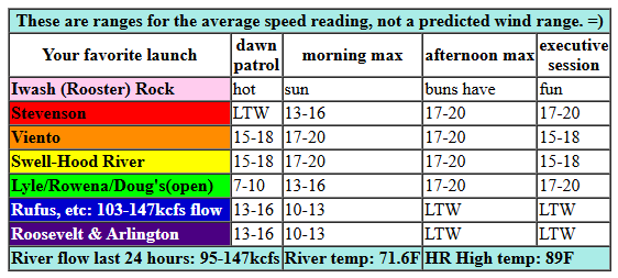
Monday started with pressures of 30.13/30.06/30.04 for early gradients of 0.07/0.02. The sky was clear all the way from the coast to the metro area. Early wind was 15-18mph between Viento and the Hatch with 10mph or less everywhere else. Mid-morning wind rises to 17-20mph from Viento to Hood River. It won’t be long before we see 17-20mph between Stevenson and Mosier. Afternoon: 16-19mph from Stevenson to Hood River with 18-21mph from Mosier to Doug’s. East of there: not much at all. River flow over the last 24 hours was 95-147kcfs, river temp is 71.6F, and high temp forecast is 89F.
RIVER FLOW FOR SITES BETWEEN AVERY (EAST OF THE DALLES) AND RUFUS: CLICK HERE FOR JOHN DAY DAM FLOW.
RIVER FLOW FOR SITES BETWEEN STEVENSON AND DOUG’S BEACH (WEST OF THE DALLES): CLICK HERE FOR THE DALLES DAM FLOW

tomorrow’s gorge wind forecast
Another round of moderate westerlies is in the cards for Tuesday, and so is heat. You’ll be very glad for any wind we get! The day starts with 14-17mph from Viento to Swell. Westerlies rise to 17-20mph from Stevenson to Mosier in the afternoon. High temp: 95F and muggy with a chance of thunder. Any storms that do develop will eventually shut down the wind. Maybe this goes without saying, but if you see thunderheads, or if you hear thunder or see lighting, get off the river!
extended Gorge wind forecast
Moderate westerlies continue on Wednesday, but thunderstorm chances skyrocket. Thanks to a relatively hot start, we could see a true (super early) Dawn Patrol at 20-23mph from Viento to the Hatch. The wind dips to 17-20mph midday, and may return at 20-23mph in the evening. I say it may, because thunderstorm chances ramp way up in the afternoon. These are elevated storms, so we could see the surface wind continue, but still… get off the water if you see storms building. It’d be a bummer if the first lightning strike of a particular storm cell struck you! High temp: mid 90s.
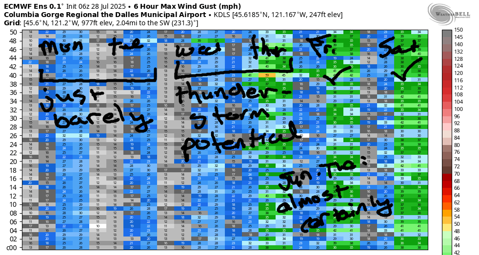
Stronger wind is forecast on Thursday, but thunderstorm chances will persist, especially in the desert. For now, let’s call the wind 25mph, but it could potentially be much stronger. The atmosphere stabilizes some on Friday, which hints at stronger westerlies. Generally speaking, the setup looks good for moderately strong to strong westerlies Friday through next Monday. Details are unclear – you can see the spread in the ensembles – but I feel hopeful. Have a great day on the river today!
Was that helpful? I knew it was! Guess what? All of this crucial work – from your personal wind and snow reports to the invaluable TATAS updates – is made possible by my relentless efforts. Maintaining this labor of love isn’t easy. Each daily forecast takes hours. Website hosting, weather model access, and back-end admin work takes time and money. That’s where you come in.
YOUR CONTRIBUTION MAKES A DIFFERENCE
- SUPPORT ACCURATE, HYPER-LOCAL WEATHER FORECASTING
- ENABLE ACCESS FOR ALL, EVEN THOSE WITH LESS MEANS
- SUPPORT A COOL HUMAN WHO WORKS HARD SO YOU CAN PLAY
Take a moment to click one of the buttons below. Donate $19.99 or more (how much does this forecast enhance your life?) and get the email in your inbox. Whether it’s a renewing subscription (auto-renew) or a one-time donation, every contribution makes a real difference. Help me keep this labor of love alive, so we can all continue playing, commuting, and living in the Gorge with peace of mind and the best weather forecasts possible. Thank you!


Hood River, Oregon 97031


JONES BEACH, SAUVIE ISLAND, & COAST FORECAST
Wind northerly unless otherwise indicated. For coast, it’s North/Central/South with the “central” at approximately Florence. Swell forecast from NWS for central coast. Jones: westerly unless otherwise stated. Sauvie Island: northerly unless otherwise stated. Coast Monday: NW10/NNW10/N20, NW swell 3′ at 8 seconds. Tuesday: N15-20/20/25-30, W 3′ @ 7. Wednesday: NNW10-15/N15/30-35, NW 3′ @ 8. Jones Monday: 19-22. Tuesday: 21-24. Wednesday: 23-26. Sauvie Island Monday: 8-11. Tuesday: 13-16. Wednesday: 16-19.
BARE BONES HOOD RIVER WEATHER FORECAST
A few high clouds stick around all day Monday. Temps start near 60 and rise to the upper 80s. Moderate westerlies. No rainbows. Tuesday will be clear then partly high cloudy with a slight chance of thunderstorms. Temps start in the low 60s and rise to the mid 90s. Muggy. Moderate westerlies. No rainbows. Wednesday will be partly high cloudy then overcast with a solid chance of thunderstorms. Temps start in the mid 60s and rise to the mid 90s. Moderate westerlies. No rainbows.
TEMIRA’S AWESOME TRAVEL ADVISORY SERVICE – MONDAY 7/28
HYPERLOCAL WEATHER FORECAST FOR THE COLUMBIA GORGE
THE DALLES, HOOD RIVER, WHITE SALMON, TROUT LAKE, STEVENSON, CASCADE LOCKS, PARKDALE, ODELL, HUSUM, BZ, MILL A, WILLARD, GOLDENDALE, RUFUS, ARLINGTON, boardman
Good morning, neighbors! Fun stuff in the forecast this week: heat, humidity, thunderstorms, and … I forgot what the fourth thing was. Just make it “kindness”, okay, cuz that won’t have any downsides. Speaking of kindness, let’s check in with our thoughtful and compassionate friends in Glenwood…
GLENWOOD THIS MORNING
It’s a chilly morning there – 44 degrees on the backup sensor, which probably puts Glenwood proper at 42 degrees, yet again, making Glenwood the answer to Life, The Universe, and Everything, yet again. Everyone in Glenwood is contemplating the question to that answer this morning. And while they may not find the question, the act of sincere contemplation can be a wisdom-producing activity either way.
TODAY’S GORGE WEATHER FORECAST
Here’s some wisdom to start your Monday: open all the doors and all the windows and capture some of this 44-60 degree air. Temps soar to 90 (west) and 95 (The Dalles eastward) today. While we’ll have a few high clouds, they won’t do much to lower temps. West wind helps you feel a little cooler: 15-20mph between Stevenson and Mosier this morning and 20mph between Stevenson and Avery this afternoon. East of there: less, which makes the Bighorn Sheep happy. They don’t like it when they have dust in their eyes. When they do, they have to remove the dust from their eyes before they can help others remove the dust.
TUESDAY’S GORGE WEATHER FORECAST
You’ll eventually be able to open your windows tonight: overnight lows will generally be in the low 60s. Capture all the cool air you can on Tuesday morning cuz Tuesday afternoon looks hot: 95 degrees on the west side and 100 degrees from The Dalles eastward. Humidity increases during the day as southerly flow sets up across the region. Thanks to the southerly flow and the humidity, there’s a slight chance of thunder along the Cascades. There’s a much higher chance of you sweating your ass off all day long. Stay hydrated! Wind: 15-20mph between Stevenson and Mosier.
WEDNESDAY’S GORGE WEATHER FORECAST
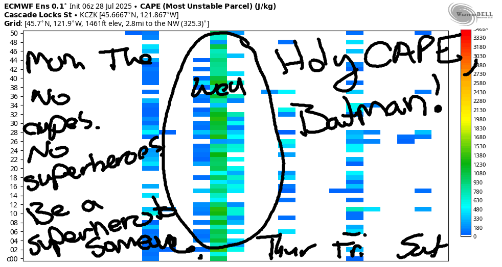
Moving on to Wednesday, hump day, and also the most interesting day this week. It’ll be too hot to hump unless you get your humping done really early! High humidity, hot weather, and southerly flow takes full advantage of a disturbance moving northward. Check out the convective available potential energy on the CAPE image. Awesome! So much CAPE that you’ll want to keep an eye out for cape-wearing superheros and supervillains and vampires and clergy and nobility and actors portraying all these folks and also for Robin saying, “Holy CAPE, Batman!” Morning temps: mid 60s or higher. Eek! Record high low that morning: 65 degrees. That one is at risk of falling!
All of this stuff sets us up for decent thunderstorm chances in the afternoon and overnight. With PWAT (available moisture) at 2.1-2.5 sigmas, any storms that do develop could drop lots of rain. PLEASE LET IT RAIN! One thing to note: with all those sigmas around, you’ll want to keep an eye out for sorority girls. While they have the best of intentions, they tend to be young, meaning they do not have a fully-developed pre-frontal cortex. They may not have the best judgment. Wind on Wednesday will be 20mph or so between Viento and Hood River in the morning and between Stevenson and The Dalles in the afternoon.
EXTENDED GORGE WEATHER FORECAST
Thunderstorm chances continue on Thursday. The day starts hot AF with the potential for a 70 degree start. Record high-low that day: 72 degrees in Hood River. High temps will be down on the west side: 85 degrees. They’ll be down near The Dalles: 91 degrees. But high temps won’t be down at all in the desert, where it’ll still be 100 degrees in the afternoon. The temp gradient across the Cascades gives us potential for very strong (maybe) west wind. Somewhat cooler, rather windy weather is forecast Friday, Saturday, Sunday, and next Monday, when somehow, we’ll already be in August. How in the world did that happen so fast? Safe travels. -TATAS
HEY! DON’T STOP READING! Is this community-focused forecast helpful to you? It sure is! It takes me a couple hours a day to write. Please join your friends and neighbors in contributing to keep it going. Venmo: @thegorgeismygym PayPal: twomirrors@gmail.com USPS: Temira / PO Box 841 / Hood River, Oregon 97031 You can test out the forecast subscription for a few days for free by signing up below. Easy! Do it!
