

GORGE WIND FORECAST
If you’re still seeing yesterday’s and it’s after 9am, try opening this in an incognito window
today’s gorge wind forecast
Hi friends! Cheers to all of you who made it on the water out near Rufus yesterday where reality beat the forecast! After that lovely west wind day, we fall into an east wind pattern for the next few days. Despite lack of agreement on the overall picture, Gorge wind forecastmodels do agree on a decent west wind day on Thursday. Seems okay at this point to pencil it in. Beyond that, uncertainty increases enough to warrant you putting the pencil down.
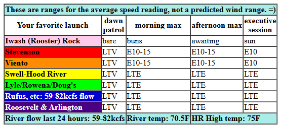
Looking at Monday morning, we have a bit of lingering onshore gradient to start the day: 30.18/30.17/30.15 for gradients of 0.01/0.02. Pressures turn offshore midday. We’ll see easterlies build to 10mph at Iwash (Rooster) Rock, 15mph near Stevenson, and 10mph near Home Valley and Viento. After 2pm, the wind drops to 10mph along the river. River flow over the last 24 hours was 59-82kcfs, river temp is 70.5F, and high temp forecast is 75F under clear sky.
RIVER FLOW FOR SITES BETWEEN AVERY (EAST OF THE DALLES) AND RUFUS: CLICK HERE FOR JOHN DAY DAM FLOW.
RIVER FLOW FOR SITES BETWEEN STEVENSON AND DOUG’S BEACH (WEST OF THE DALLES): CLICK HERE FOR THE DALLES DAM FLOW

tomorrow’s gorge wind forecast
Tuesday sees stronger easterlies thanks to west side heating that outpaces desert heating. Add in a nice cap that keeps the wind on the river (for the most part), and you’ll have enough wind to get you out there. The day starts with 30mph at Iwash (Rooster) Rock, 25mph near Stevenson, and 20mph at Viento and Home Valley. Easterlies hold through the morning. Standard-issue afternoon fade kicks in and leaves us with: 15-20mph at Iwash, 15mph at Stevenson, 5-10mph near Hood River, and 10mph east of Hood River. High temp: 82F with clear sky.
extended Gorge wind forecast
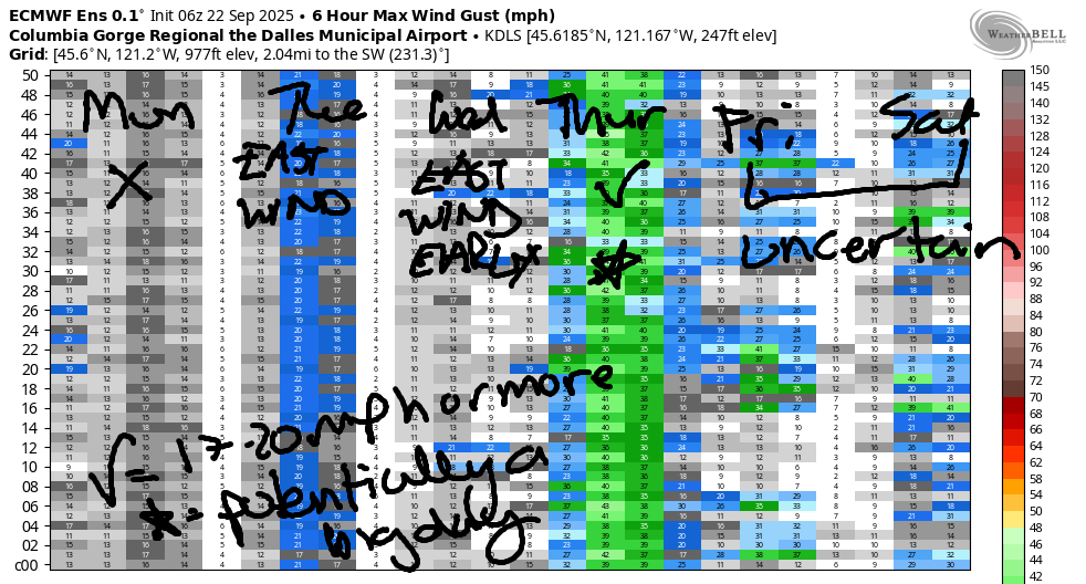
Wednesday starts with easterlies at 15mph near Stevenson and 15-20mph near Iwash Rock. A quick drop-off is forecast. Late afternoon sees the wind (maybe?) turn onshore with 10mph from Stevenson to Viento or perhaps to Hood River. High temp: 85F with sunshine.
Westerlies return on Thursday as a trough drops south, brings cooler air to the west side, and nudges the warm ridge out into the desert. Result: strong onshore pressure gradients. As of this morning, marine clouds look minimal, which will limit the strength of the wind somewhat; that said, I think we’ll see 26-29mph in the Corridor (Viento-Hood River) and Near East (Rowena area) with some potential for Rufus. Beyond Thursday, uncertainty skyrockets. There is decent agreement on some sort of ridging over the weekend which would either bring too-light westerlies or some sort of easterlies, but let’s wait a bit before making any plans. Have a great day out there today! See you on the Nch’i Wana!
Was that helpful? I knew it was! Guess what? All of this crucial work – from your personal wind and snow reports to the invaluable TATAS updates – is made possible by my relentless efforts. Maintaining this labor of love isn’t easy. Each daily forecast takes hours. Website hosting, weather model access, and back-end admin work takes time and money. That’s where you come in.
YOUR CONTRIBUTION MAKES A DIFFERENCE
- SUPPORT ACCURATE, HYPER-LOCAL WEATHER FORECASTING
- ENABLE ACCESS FOR ALL, EVEN THOSE WITH LESS MEANS
- SUPPORT A COOL HUMAN WHO WORKS HARD SO YOU CAN PLAY
Take a moment to click one of the buttons below. Donate $19.99 or more (how much does this forecast enhance your life?) and get the email in your inbox. Whether it’s a renewing subscription (auto-renew) or a one-time donation, every contribution makes a real difference. Help me keep this labor of love alive, so we can all continue playing, commuting, and living in the Gorge with peace of mind and the best weather forecasts possible. Thank you!


Hood River, Oregon 97031


JONES BEACH, SAUVIE ISLAND, & COAST FORECAST
Wind northerly unless otherwise indicated. For coast, it’s North/Central/South with the “central” at approximately Florence. Swell forecast from NWS for central coast. Jones: westerly unless otherwise stated. Sauvie Island: northerly unless otherwise stated. Coast Monday: 15/20/30, W swell 7′ at 11 seconds. Tuesday: 20/15-20/15, NW 6′ @ 11. Wednesday: 20-25/20-25/25-30, NW 7′ @ 10. Jones Monday: LTW. Tuesday: LTE. Wednesday: 13-16. Sauvie Island Monday: 5-8. Tuesday: LTN. Wednesday: 14-17.
BARE BONES HOOD RIVER WEATHER FORECAST
Clear sky today. Temps start in the upper 40s and rise to the mid 70s. Light easterlies. No rainbows. Tuesday will be sunny. Temps start in the upper 40s and rise to the low 80s. Light easterlies. No rainbows. Wednesday will be sunny. Temps start in the low 50s and rise to the mid 80s. Light easterlies becoming very light westerlies late. No rainbows.
TEMIRA’S AWESOME TRAVEL ADVISORY SERVICE
HYPERLOCAL WEATHER FORECAST FOR THE COLUMBIA GORGE
THE DALLES, HOOD RIVER, WHITE SALMON, TROUT LAKE, STEVENSON, CASCADE LOCKS, PARKDALE, ODELL, HUSUM, BZ, MILL A, WILLARD, GOLDENDALE, RUFUS, ARLINGTON, boardman
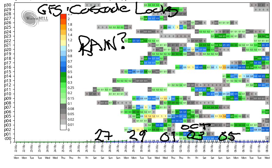
Good morning, neighbors! It’s officially fall, and official fall weather has started with a clear, cool, calm morning. We’ll see a few of those this week. Models continue to hold off on rain until the very end of the month, and even then, the timing and certainty of a soaking are unclear.
Glenwood this morning. COLD!
Before we dive in to all that, let’s dive into something quite clear: the sky this morning. Thanks to the clear sky, light wind, and 850mb temps around 7C, Glenwood dropped to 31 degrees this morning. Wow. Everyone in Glenwood is shaking their heads this morning, but also recognizing that this isn’t a particularly early first frost there. Other cool spots: 38F on Trout Creek Ridge Road (Parkdale), 40F near Centerville, and a few 39 degree readings near Dufur. Temps climb to the mid 70s (west and east) and near 80F (The Dalles). Light/variable wind this morning picks up to E 10-15mph near Iwash (dick) Rock, Cascade Locks, and Viento midday. UP in the hills, easterlies rise to 15mph. To the east of Viento along the river, easterlies remain under 10mph.
Tomorrow’s Gorge weather forecast
Tuesday will be another brilliant (but warm) fall day: clear sky, sunshine, east wind. Morning easterlies max out at 30mph near Iwash (cock) Rock and 25mph near Stevenson with 15-20mph as far east as Viento. East of Viento, easterlies rise to 5-10mph in the afternoon. Away from the river and up in the hills, we’ll see easterlies at 15-20mph. Go high enough, and you’ll find south wind at 10-15mph. Go even higher in elevation, and you’ll run out of oxygen and pass out. You’ll probably need a plan or a helicopter to get that high, so don’t worry too much about that happening. High temps on Tuesday range from 82F (west) to 87F (The Dalles) and 81F (watermelon-growing zones near Hermiston).
Wednesday’s (succinct) Gorge weather forecast
Wednesday looks warm (85-91F) and sunny (Sol) with easterlies (15-20mph) in the morning and westerlies (5-10mph) in the evening.
Extended Gorge weather forecast
Moving on to Thursday: something different happens. A system up near Alaska nudges cooler air towards us. This doesn’t change the dry weather, but it does take temps down a bit: 77F-86F is the forecast range from west to east. The presence of this cool, dense air to the west brings back the west wind. As of this morning, we’re looking at 25-30mph. Beyond Thursday, there’s less agreement in the forecast models. Next weekend, FWIW, looks dry. Beyond that, we start to see some sign of rain in the models, but the exact timing and exact likelihood of rain is difficult to ascertain. So I’ll leave it here for now. Safe travels. -TATAS
HEY! DON’T STOP READING! Is this community-focused forecast helpful to you? It sure is! It takes me a couple hours a day to write. Please join your friends and neighbors in contributing to keep it going. Venmo: @thegorgeismygym PayPal: twomirrors@gmail.com USPS: Temira / PO Box 841 / Hood River, Oregon 97031 You can test out the forecast subscription for a few days for free by signing up below. Easy! Do it!
MT HOOD SNOW FORECAST

CURRENTLY ON VACATION. WILL RETURN SOMETIME BEFORE THE START OF SKI SEASON AT MEADOWS, TIMBERLINE AND SKIBOWL. SAME GOES FOR THE NORDIC SKIING SEASON AT MEADOWS AND TEACUP!
