

GORGE WIND FORECAST
If you’re still seeing yesterday’s and it’s after 9am, try opening this in an incognito window
today’s gorge wind forecast
Hi friends! East wind is on the schedule for today and tomorrow (Monday and Tuesday). That’ll be followed by enough west wind to get you on the water on Wednesday. On Thursday, not much happens (other than gardening). Friday and Saturday have potential out in the eastern Gorge, especially Saturday, which could be quite windy… still lots of uncertainty in the Gorge wind forecast for the weekend, but start watching that Saturday forecast closely!
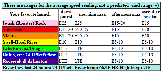
Monday starts off with clear sky across the region and pressures of 30.12 (PDX) and 30.20 (DLS). That’s 0.08 offshore, but it should build into the morning. Working against us is the fact that the easterlies will also spill over the Cascades; wind speeds are generally much higher when that doesn’t happen. So… As of last look, the forecast for this morning is 25mph at Iwash (Rooster) Rock and 20-25mph at Stevenson, Home Valley, and Viento. The wind holds until early afternoon and then starts to fade. Iwash ends the day at 15mph, and Stevenson ends at 10-15mph. Areas east of Viento all the way into the desert pick up to E 10mph this afternoon. River flow over the last 24 hours was 74-119kcfs, river temp is 66.9F, and high temp forecast is 71F for Hood River after a 38F start. Brr!
RIVER FLOW FOR SITES BETWEEN AVERY (EAST OF THE DALLES) AND RUFUS: CLICK HERE FOR JOHN DAY DAM FLOW.
RIVER FLOW FOR SITES BETWEEN STEVENSON AND DOUG’S BEACH (WEST OF THE DALLES): CLICK HERE FOR THE DALLES DAM FLOW

tomorrow’s gorge wind forecast
Tuesday sees the easterlies stay where they belong – on the river – but they’ll fade faster. We’ll have an early 30mph session at Iwash and 25mph at Stevenson. By noon, the wind drops to 15-20mph or less, and by early evening, it goes calm. High temp: 74F after a low 40s start.
extended Gorge wind forecast
On Wednesday, a weak little low approaches the coast from the NNW. This nudges the warmest weather to the east and sets up a decent cross-Cascade temp/pressure gradient. Models have low clouds settled in the metro area for much of the day. As of this morning, models have 18-21mph from Viento to Mosier early with 10-13mph east to Arlington. Afternoon wind is forecast to rise to 24-27mph from Stevenson to Rufus with 18-21mph at Arlington. Given the active weather pattern, this forecast is likely to change some.
Unlikely to change: Thursday’s forecast, when models have under 15mph out of the west. Continued onshore temp gradients set us up for (probably) a mid 20s day out east on Friday. A system moves inland on Saturday. Models currently have this accompanied by very strong WNW wind aloft; if this plays out, we’ll see a big day for Rufus and potentially Arlington. Fingers crossed. Sunday’s forecast has continued westerlies, but probably lighter, and probably focused in the Corridor. Next weekend is a long ways out, and this forecast is subject to change. For now, keep watching Saturday. Enjoy the beautiful fall weather today. I’ll see you on the Nch’i Wana!
Was that helpful? I knew it was! Guess what? All of this crucial work – from your personal wind and snow reports to the invaluable TATAS updates – is made possible by my relentless efforts. Maintaining this labor of love isn’t easy. Each daily forecast takes hours. Website hosting, weather model access, and back-end admin work takes time and money. That’s where you come in.
YOUR CONTRIBUTION MAKES A DIFFERENCE
- SUPPORT ACCURATE, HYPER-LOCAL WEATHER FORECASTING
- ENABLE ACCESS FOR ALL, EVEN THOSE WITH LESS MEANS
- SUPPORT A COOL HUMAN WHO WORKS HARD SO YOU CAN PLAY
Take a moment to click one of the buttons below. Donate $19.99 or more (how much does this forecast enhance your life?) and get the email in your inbox. Whether it’s a renewing subscription (auto-renew) or a one-time donation, every contribution makes a real difference. Help me keep this labor of love alive, so we can all continue playing, commuting, and living in the Gorge with peace of mind and the best weather forecasts possible. Thank you!


Hood River, Oregon 97031


JONES BEACH, SAUVIE ISLAND, & COAST FORECAST
Wind northerly unless otherwise indicated. For coast, it’s North/Central/South with the “central” at approximately Florence. Swell forecast from NWS for central coast. Jones: westerly unless otherwise stated. Sauvie Island: northerly unless otherwise stated. Coast Monday: 20/15/20-25, NW swell 5′ at 12 seconds. Tuesday: 20/15-20/5-10, NW 5′ @ 11. Wednesday: LTW/LTW/N10-15, NW 7′ @ 8. Jones Monday: LTE. Tuesday: 16-19. Wednesday: LTV. Sauvie Island Monday: E 10. Tuesday: LTV. Wednesday: LTS.
BARE BONES HOOD RIVER WEATHER FORECAST
Clear sky this morning. Temps start in the upper 30s and rise to the low 70s. Light easterlies. No rainbows. Tuesday will be sunny. Temps start in the low 40s and rise to the mid 70s. Light easterlies. No rainbows. Wednesday will be cloudy then partly cloudy. Temps start in the mid 40s and rise to the upper 60s. Moderately strong westerlies. No rainbows.
TEMIRA’S AWESOME TRAVEL ADVISORY SERVICE
HYPERLOCAL WEATHER FORECAST FOR THE COLUMBIA GORGE
THE DALLES, HOOD RIVER, WHITE SALMON, TROUT LAKE, STEVENSON, CASCADE LOCKS, PARKDALE, ODELL, HUSUM, BZ, MILL A, WILLARD, GOLDENDALE, RUFUS, ARLINGTON, boardman
Good morning, neighbors! It’s official – we have our first hard frost of the season, and we also have our first light frost in many areas. With temps at 850mb (~5000′) forecast to be 4-5C warmer tomorrow, today’s the coldest morning we’ll see for a bit. Keep a close eye on the start of next week – 850mb temps are forecast to drop to +1C, cold enough for more widespread frost if we can get clear sky and light wind… More importantly, keep an eye on the snow level this weekend: starting Saturday, it’ll be below 6000′ for four days straight, potentially enough to get a nice layer of snow at the ski resort bases!
Glenwood this morning
In the meantime… Glenwood dropped to 27F this morning according to NWS. That’s the end of tomato season there! Other locations below freezing: Centerville (28), Steel Road area in The Dalles (31), and probably some others. Parkdale was in the 32-36F range, just cold enough for a light frost (it doesn’t have to be 32F for frost to occur – radiational cooling can drive ground frost at warmer air temps!).
Today’s Gorge weather forecast
Today eventually warms up to the low 70s most places in the lowlands with 74F in The Dalles. East wind wind be 20-25mph between Iwash (pee-pee) Rock and Viento this morning and will drop to 15mph this afternoon. East of Viento, easterlies rise to 5-10mph this afternoon. Stronger east wind is forecast in the hills: 15-20mph. Overnight: clear sky and chilly.
Tuesday’s Gorge weather forecast
We’ll wake to 37-42F most places on Tuesday morning with 32F likely in Glenwood. Clear sky starts the day. Afternoon sees a few high clouds, but that won’t affect highs: 74F for Hood River, 78F for The Dalles, and 72F out in the desert. After a breezy start (20mph near Stevenson, 30mph near Iwash Rock), the wind eventually goes calm or nearly calm all through the Gorge and at all elevations.
Extended Gorge weather forecast
Low clouds swing inland early Wednesday morning thanks to a weak little low offshore. In response, the heat low moves from Portland, which is war-ravaged by a few people wearing inflatable costumes, to the desert, where costumed people don’t constitute an invasion. PEOPLE, WAKE UP! HAVING THE MILITARY DEPLOYED AGAINST PROTESTORS IS NOT AMERICAN. FREE SPEECH IS A THING. DEFEND IT. GRAB YOUR FLAG AND STAND UP AGAINST THIS!
What were we talking about?
Oh, Wednesday. Yeah, some clouds move in for the morning on the west side. Afternoon: partly cloudy everywhere, but unlikely to have any raindrops. Sad. West wind rises to 25mph all the way from Stevenson to Rufus and perhaps to Arlington in the afternoon. Temps range from 67F (west) to 73F (desert). Ridging (calmer, warmer, sunnier weather) moves in for Thursday. More active weather is forecast Friday through Monday with increasing chances of rain as we move towards next week. As of right now, the high temp forecast for Hood River for Saturday is a mere 59F. That’s cold. You’ll want a warm jacket for Harvest Fest! Safe travels. -TATAS
HEY! DON’T STOP READING! Is this community-focused forecast helpful to you? It sure is! It takes me a couple hours a day to write. Please join your friends and neighbors in contributing to keep it going. Venmo: @thegorgeismygym PayPal: twomirrors@gmail.com USPS: Temira / PO Box 841 / Hood River, Oregon 97031 You can test out the forecast subscription for a few days for free by signing up below. Easy! Do it!
MT HOOD SNOW FORECAST

CURRENTLY ON VACATION. WILL RETURN SOMETIME BEFORE THE START OF SKI SEASON AT MEADOWS, TIMBERLINE AND SKIBOWL. SAME GOES FOR THE NORDIC SKIING SEASON AT MEADOWS AND TEACUP!
