

GORGE WIND FORECAST
If you’re still seeing yesterday’s and it’s after 9am, try opening this in an incognito window
today’s gorge wind forecast
Hi friends! Nice day we had yesterday, eh? We’ll have another windy one today! After today, the setup is less conducive to strong wind, but westerlies of some sort continue through at least Thursday. Looking at next Friday through Sunday, there’s soooooooo much uncertainty in the models. This is due to uncertainty about the strength and placement of a ridge of high pressure and associated warmer weather. Models for next weekend currently have anything from light easterlies to strong westerlies. We’re all going to have to wait to make plans if those plans rely on knowing the Gorge wind forecast!
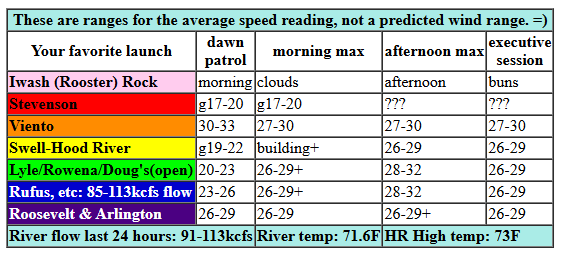
Today’s forecast is more clear: windy. Little fluffy low clouds (and the marine layer) were past Hood River as I was writing this. Pressures at 7am were 30.12/30.01/29.94 for gradients of 0.11 (PDX-DLS) and 0.07 (DLS-PSC). This screams “Mosier to Rufus”, and indeed, that’s how the day started. Also worth noting: low clouds will stick around in the metro area and perhaps as far east as Cascade Locks all day. When they burn back west of Swell, hold on! Early wind was 17-20mph between Stevenson and The Dalles (except Viento: 30mph). The Maryhill-Arlington zone started at 22-25mph with 17-20mph out at Threemile.
Moving pieces offshore (an approaching low and associated front and ridging shifting eastward) may impact wind quality. Still… by late morning, we’ll have 27-30mph from Viento to Rufus with 23-26mph from Philippi Canyon to Threemile. Swell is going to be slow to join – it won’t fill in until the clouds burn back to Underwood or sites farther west. Afternoon: 28-32mph from Viento to Rufus with 26-29mph from Philippi Canyon to Threemile. Stevenson really depends on what the clouds do today. If they stay, it’ll be gusty and light. If they go, it’ll still be gusty, but it’ll be stronger. The wind drops 3-6mph everywhere after 5pm, but it’ll still be plenty windy for the Executive Session! River flow over the last 24 hours was 85-113kcfs, river temp is 71.6F, and high temp forecast is 73F for Hood River and low 80s out in the desert.
RIVER FLOW FOR SITES BETWEEN AVERY (EAST OF THE DALLES) AND RUFUS: CLICK HERE FOR JOHN DAY DAM FLOW.
RIVER FLOW FOR SITES BETWEEN STEVENSON AND DOUG’S BEACH (WEST OF THE DALLES): CLICK HERE FOR THE DALLES DAM FLOW

tomorrow’s gorge wind forecast
Moving on to Tuesday, we see another breezy day. This day will be affected by a couple of week weather impulses. Opening gambit looks like 18-21mph from Stevenson to Arlington (more at Viento) with lots of clouds. Those clouds keep building through late morning, which shifts the wind east. For the early afternoon session, you’ll find gusty 14-18mph from Stevenson to Hood River with 21-24mph from Mosier to Avery and 17-20mph from Rufus to Arlington. As desert heating kicks in mid afternoon, westerlies rise to 25-28mph from Lyle to Arlington. Remember that this forecast predicts to the sensors, and that the sensors out east do not match Swell. 25-28mph out east is about equivalent to 20-23mph at Swell. Still windy, tho! High temps: 80F for Hood River and 87F out at Rufus.
extended Gorge wind forecast
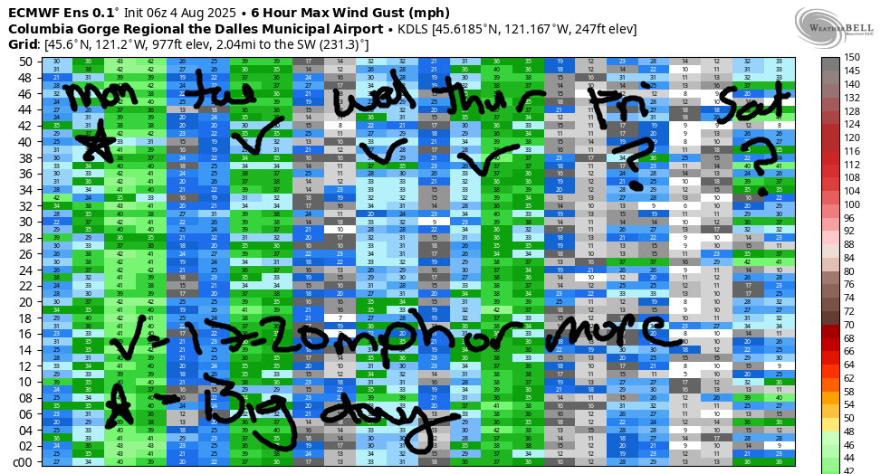
A cool, cloudy, and still-breezy day is forecast Wednesday. The day starts with less than 10mph near Hood River and 17-20mph from Lyle to Arlington. Westerlies eventually rise to 21-24mph from Lyle to Rufus with 18-21mph at Arlington. The west side is likely to stay below 15mph with lots of clouds. Ensembles have a windier day on Thursday, perhaps 23-26mph, as cool air on the west side combines with heat in the desert. Looking at Friday and the weekend, all I see is uncertainty. It’s so uncertain that I’m not even going to guess at this point – models have everything from easterlies to strong westerlies! So, that’s it for now. Have a great day on the river today!
Was that helpful? I knew it was! Guess what? All of this crucial work – from your personal wind and snow reports to the invaluable TATAS updates – is made possible by my relentless efforts. Maintaining this labor of love isn’t easy. Each daily forecast takes hours. Website hosting, weather model access, and back-end admin work takes time and money. That’s where you come in.
YOUR CONTRIBUTION MAKES A DIFFERENCE
- SUPPORT ACCURATE, HYPER-LOCAL WEATHER FORECASTING
- ENABLE ACCESS FOR ALL, EVEN THOSE WITH LESS MEANS
- SUPPORT A COOL HUMAN WHO WORKS HARD SO YOU CAN PLAY
Take a moment to click one of the buttons below. Donate $19.99 or more (how much does this forecast enhance your life?) and get the email in your inbox. Whether it’s a renewing subscription (auto-renew) or a one-time donation, every contribution makes a real difference. Help me keep this labor of love alive, so we can all continue playing, commuting, and living in the Gorge with peace of mind and the best weather forecasts possible. Thank you!


Hood River, Oregon 97031


JONES BEACH, SAUVIE ISLAND, & COAST FORECAST
Wind northerly unless otherwise indicated. For coast, it’s North/Central/South with the “central” at approximately Florence. Swell forecast from NWS for central coast. Jones: westerly unless otherwise stated. Sauvie Island: northerly unless otherwise stated. Coast Monday: LTNW/NW5-10/N15-20, W swell 2′ at 14 seconds. Tuesday: WSW10-15/variable to 10/N10-15, W 2′ @ 14. Wednesday: LTV/LTV/N15, W 5′ @ 11. Jones Monday: 5-10. Tuesday: 10-13. Wednesday: LTW. Sauvie Island Monday-Wednesday: 9-12ish.
BARE BONES HOOD RIVER WEATHER FORECAST
Partly cloudy sky this morning. Mostly clear this afternoon. Temps start near 60 and rise to the low 70s. Strong westerlies. No rainbows. Tuesday will be mostly cloudy. Temps start in the mid 50s and rise to the low 80s. Moderate westerlies. No rainbows. Wednesday will be cloudy with a chance of drizzle or sprinkles. Temps start in the low 60s and rise to the upper 70s. Light to moderate westerlies. No rainbows.
TEMIRA’S AWESOME TRAVEL ADVISORY SERVICE
HYPERLOCAL WEATHER FORECAST FOR THE COLUMBIA GORGE
THE DALLES, HOOD RIVER, WHITE SALMON, TROUT LAKE, STEVENSON, CASCADE LOCKS, PARKDALE, ODELL, HUSUM, BZ, MILL A, WILLARD, GOLDENDALE, RUFUS, ARLINGTON, boardman
Good morning, neighbors! An unseasonably cool week is on tap. TATAS approves! Soak it up. Next weekend looks hotish. Highlights this week include lots of clouds, a slight chance of drizzle on Wednesday, and excellent sleeping conditions as overnight temps (mostly) stay around 60 degrees or less.
glenwood this morning
Looking at Monday morning, I am doing so with sleepy eyes. But I seem to remember that we always check in with Glenwood first. It’s 52 degrees in Glenwood this morning, and everyone is getting ready for work. Work, in Glenwood, is internal before it’s external. Everyone is reminding themselves to be kind to themselves and others. I heard somewhere that everyone in Glenwood is taking a stand for kindness and a stand against cruelty and ill-will. Be. Like. Glenwood.
today’s gorge weather forecast
The rest of us started this morning between 50 (a random station near The Dalles) and the mid 60s (locations east of The Dalles, mainly). Temps rise to the low 70s (west), 80 (The Dalles), and mid 80s (out where the watermelons roam). We’ll see low clouds west of Hood River for much of the day with a few high clouds scattered about for areas east of that low cloud zone. As you may know, this setup in summer results in strong west wind. Indeed, that’s what we’re expecting today: westerlies rise to 25-35mph between Viento and the Arlington Triangle, strongest between noon and 5pm. Stevenson, being mostly cloudy today, will have sleepier wind, but it’ll still rise to 20mph or so. One thing to watch out for today is censorship. As you can see from the photo, it’s getting really, really bad. This is what happens under authoritarian regimes – books are banned, words are banned, progressive ideas are banned, and then people are banned. It starts small, but then… First they came for the … Don’t wait to resist until you’re part of the oppressed. It’ll be too late then.
tuesday’s gorge weather forecast
If that disrupts your sleep, take heart: tonight will be great for sleeping – cool and breezy and cloudy. . As a matter of fact, many of us will have our windows open to the outside air all the way through from last night (Sunday night) to Tuesday morning. Back to Tuesday’s weather… an approaching system nudges low clouds inland through mid-morning. East of Hood River, there will be high clouds. Mid-level clouds slide inland mid-morning. With all these clouds dancing around, you might think there would be rain. No, sadly, probably not on Tuesday. Temps eventually rise near 80 (west), 85 (The Dalles), and 89 (out east in the land of free-range watermelons). West wind will be 15-20mph to start all the way from Stevenson to Arlington. Afternoon wind holds at 20mph west of Lyle and builds to 25-30mph from Lyle to the Arlington dodecahedron.
wednesday’s gorge weather forecast
Another great sleeping night is on tap Tuesday into Wednesday. Let that rejuventate and re-energize you. All sorts of clouds – low, middle, and high – greet us all day long. Temps start near 60. They rise to the mid 70s (west), low 80s (The Dalles), and mid 80s (where cowboys are eyeing each other hungrily as they lasso up those escaped watermelons – there’s nothing sexier to cowboys than cowboys with ropes). Models are all over the place on the potential for rain Wednesday. GFS deterministic: not enthusiastic at all. Euro ensembles: trace to 0.19” for The Dalles and 0.07” to 0.22” for Cascade Locks. West wind will be less than 15mph west of Mosier all day. East of Mosier: 15-20mph in the morning and 20-25mph in the afternoon.
Valuable Advice (for) Gardeners Inhabiting Neighboring Areas: the possibility of rain (and accompanying high humidity) makes me think of powdery mildew. Actually, I’m thinking about it because I noticed it starting on my pumpkin plants yesterday despite having sprayed last week. While there’s no non-toxic systemic application for your garden plants, there are good innocuous topicals: milk and baking soda. I’ll let you consult with AI for the application rates and frequency of application. I consulted AI about my hardcore, punk rock, straight-edge sprays this morning. Remember to coat both the top and bottom of the leaves if you’re spraying topicals.
extended gorge weather forecast
Moving on to the rest of the week (after you spray for powdery mildew): Thursday brings continued cool weather. Starting Friday, temps begin to climb. Peak heat: probably Monday. Models continue to have a wide range of temps and duration for this “heat wave”. It really depends on where the ridge sets up and how far inland it extends. A clear sign of this uncertainty is visible in the wind speed and direction, which has a lot to do with the location of hottest weather: the forecast has everything from easterlies to strong westerlies! Generally speaking, next week looks normal-ish after the short-lived heat wave. Still no significant rain in the forecast. Safe travels. -TATAS
HEY! DON’T STOP READING! Is this community-focused forecast helpful to you? It sure is! It takes me a couple hours a day to write. Please join your friends and neighbors in contributing to keep it going. Venmo: @thegorgeismygym PayPal: twomirrors@gmail.com USPS: Temira / PO Box 841 / Hood River, Oregon 97031 You can test out the forecast subscription for a few days for free by signing up below. Easy! Do it!
