

GORGE WIND FORECAST
If you’re still seeing yesterday’s and it’s after 9am, try opening this in an incognito window
today’s gorge wind forecast
Hi friends! It was good spending some time on the river with you again yesterday! Chances of that happening again today are good as a system swings through in the afternoon. Lesser wind on Tuesday gives way to somewhat stronger wind on Wednesday and Thursday. Beyond that, model uncertainty increases. I’ll be gone again this weekend helping on a retreat. I might have time while I’m there to write The Gorge wind forecast, but also might not. After that – I’m around until early December. But enough about me… on to your forecast!
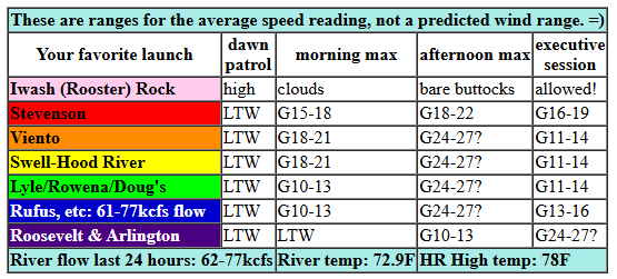
Monday started off with pressures of 30.03/29.98/29.96 for gradients of 0.05/0.02. Marine clouds: non-existent. Incoming weather system: check, with rain or showers forecast after 2pm. Morning wind totters along at 10mph or less. By late morning, the wind ramps up to gusty 18-21mph from Stevenson to Mosier with 11-14mph in the Lyle-Doug’s zone. Out east: nothing this morning.
As a weather system approaches from the south, the atmosphere destabilizes and the wind increases. If we get lucky, we’ll have a couple hours of very up-and-down 24-27mph from Viento to Mosier, then from Mosier to Rufus, then farther out east. It’s possible we could see a short period of very gusty 28-31mph at the near east (Rowena zone) and Rufus areas mid-afternoon, but you’ll probably need to be pre-positioned to catch it. Models hint at a brief Executive Session (>5pm) blast at Arlington as well. This whole setup is low-probability and high risk of failure. Fingers crossed anyway for some high-wind fun. River flow over the last 24 hours was 61-77kcfs, river temp is 72.9F (potentially lethal to salmon), and high temp forecast is 78F for Hood River and 84F out east.
RIVER FLOW FOR SITES BETWEEN AVERY (EAST OF THE DALLES) AND RUFUS: CLICK HERE FOR JOHN DAY DAM FLOW.
RIVER FLOW FOR SITES BETWEEN STEVENSON AND DOUG’S BEACH (WEST OF THE DALLES): CLICK HERE FOR THE DALLES DAM FLOW

tomorrow’s gorge wind forecast
On Tuesday, a cool low will settle in over our region. Surface-based instability will disrupt the quality of the wind. The days starts with 10-13mph from Stevenson to Arlington. By late morning, westerlies rise to 14-17mph from Stevenson to the Hatch with 17-20mph between Hood River and Doug’s. Avery joins mid to late afternoon. In the evening, we’ll also have 17-20mph from Avery to Arlington. High temp: 72F for Hood River and 78F in the desert.
extended Gorge wind forecast
Wednesday’s setup includes cool air offshore and a hot low moving north into the Washington desert in the afternoon. Morning wind will be 17-20mph from Viento to Hood River with 10-13mph east of Hood river to Arlington. We should see a period of 21-24mph from Viento to Mosier mid to late morning thanks to a nice marine layer in the metro area. Afternoon wind shifts east: 25-28mph from Mosier to Arlington with gusty 16-19mph from Stevenson to Hood River. Instability could be an issue on Wednesday, meaning the wind may be gustier than normal and up-and-down throughout the day. High temp: 73F for Hood River and 79F out in the desert.
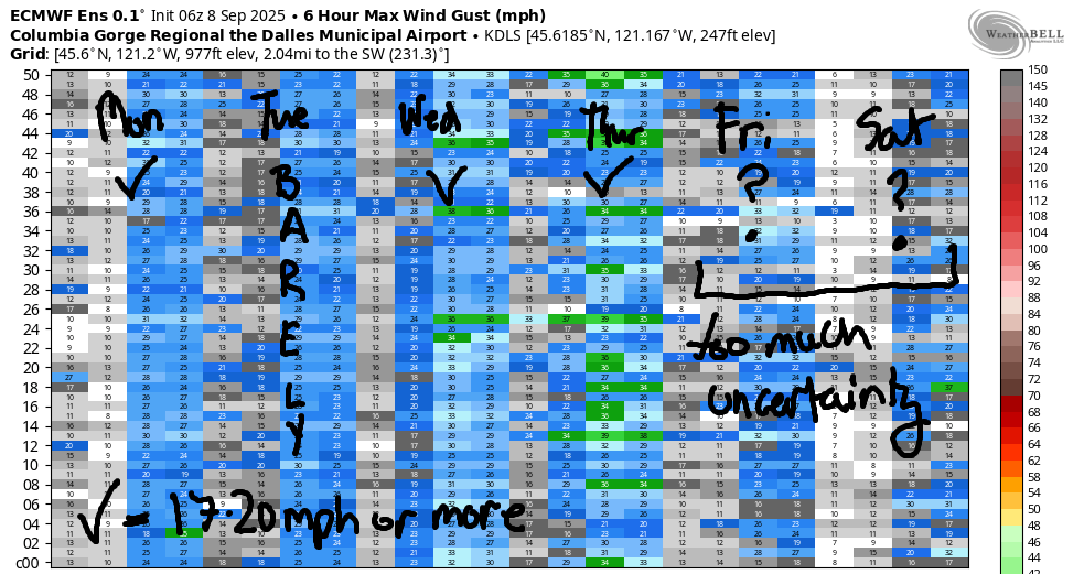
Looking at the extended forecast… Thursday currently looks about the same strength as Wednesday if you believe the Euro ensembles. GFS deterministic really wants a big day on Thursday, but there’s no clear sign of that in the Euro. Uncertainty increases as we head into the weekend. Friday’s a maybe with potential for upper teens. As of right now, the Euro ensembles have Saturday as a light day and Sunday/Monday with some potential for westerlies. Honestly, there’s way too much uncertainty to make plans yet based on what I’m seeing. So… let’s just plan for today. See you on the Nch’i Wana!
Was that helpful? I knew it was! Guess what? All of this crucial work – from your personal wind and snow reports to the invaluable TATAS updates – is made possible by my relentless efforts. Maintaining this labor of love isn’t easy. Each daily forecast takes hours. Website hosting, weather model access, and back-end admin work takes time and money. That’s where you come in.
YOUR CONTRIBUTION MAKES A DIFFERENCE
- SUPPORT ACCURATE, HYPER-LOCAL WEATHER FORECASTING
- ENABLE ACCESS FOR ALL, EVEN THOSE WITH LESS MEANS
- SUPPORT A COOL HUMAN WHO WORKS HARD SO YOU CAN PLAY
Take a moment to click one of the buttons below. Donate $19.99 or more (how much does this forecast enhance your life?) and get the email in your inbox. Whether it’s a renewing subscription (auto-renew) or a one-time donation, every contribution makes a real difference. Help me keep this labor of love alive, so we can all continue playing, commuting, and living in the Gorge with peace of mind and the best weather forecasts possible. Thank you!


Hood River, Oregon 97031


JONES BEACH, SAUVIE ISLAND, & COAST FORECAST
Wind northerly unless otherwise indicated. For coast, it’s North/Central/South with the “central” at approximately Florence. Swell forecast from NWS for central coast. Jones: westerly unless otherwise stated. Sauvie Island: northerly unless otherwise stated. Coast Monday: NW5-10/LTN/LTS, W swell 2′ at 15 seconds. Tuesday: 15/15/15, W 2′ @ 13. Wednesday: LTNW/LTNW/N20, W 4′ @ 12. Jones Monday: 5-8. Tuesday: 10-13. Wednesday: 14-17. Sauvie Island Monday: LTN. Tuesday: 7-10. Wednesday: 5-8.
BARE BONES HOOD RIVER WEATHER FORECAST
Increasing clouds today with showers or sprinkles tonight. Temps start in the upper 50s (OPEN ALL THE WINDOWS) and rise to the upper 70s. Moderate to moderately strong westerlies in the afternoon. 18% chance of rainbows. Tuesday will be mostly cloudy with a chance of showers. Temps start in the upper 50s (open windows) and end in the low 70s (keep them open!). Muggy. Moderate westerlies. 7% chance of rainbows. Wednesday will be cloudy then partly cloudy. Temps start in the mid 50s (open windows) and end in the low 70s (open windows all day!). Muggy. Moderate to moderately strong westerlies. No rainbows.
TEMIRA’S AWESOME TRAVEL ADVISORY SERVICE – MONDAY
HYPERLOCAL WEATHER FORECAST FOR THE COLUMBIA GORGE
THE DALLES, HOOD RIVER, WHITE SALMON, TROUT LAKE, STEVENSON, CASCADE LOCKS, PARKDALE, ODELL, HUSUM, BZ, MILL A, WILLARD, GOLDENDALE, RUFUS, ARLINGTON, boardman
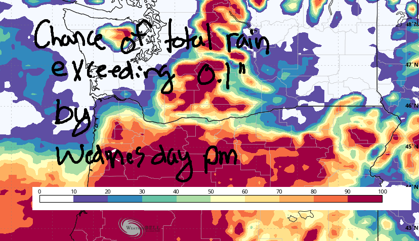
Good morning, neighbors! Something different this way comes today, namely a weather system from the south. Models have been backing off on rain amounts with this system as the associated low stays just far enough south that associated moisture does (mostly) the same. Take a look at the Euro ensemble prediction for rain totals of 0.1” or more. Not super hopeful. Oh well. At least temps will be lower. Humidity, however will be high, and humidity without rain is like sexual stimulation without orgasm… somewhat frustrating.
Glenwood this morning
Speaking of… in Glenwood this morning, nobody is frustrated by the temps: it’s 44 degrees, cool enough that a brisk walk won’t cause anyone to break a sweat. Especially not the dogs being walked. Dogs don’t sweat. That’s why they pant. Humans pant as a last resort.
Today’s Gorge weather forecast
Weather today includes increasing clouds (from the south, not the west). We’ll see showers/sprinkles after 2pm or maybe after 5pm. Expect them first in South Wasco and the Parkdale area and then slowly moving north. West wind picks up with the arrival of this system. Early wind will be 5-10mph out of the west all through the Gorge. By late morning: 15-20mph from Stevenson to Mosier. Afternoon: a 60-120 minute burst of strong wind is possible. It’ll move from west to east. Out fishing? Be prepared for a sharp uptick from no wind to very strong wind this afternoon or evening.
Tomorrow’s Gorge weather forecast
Overnight, humidity sticks around, but temps drop below 60 degrees. Sleep well, everyone! Previous forecasts had some rain on Tuesday, but the current forecast just has humidity. And associated sexual frustration. It’s possible instability could trigger some afternoon showers. Fingers crossed for that. Other than that… a cloudy morning gives way to a partly cloudy afternoon. West wind starts at 10-15mph from Stevenson to Arlington and rises to 15-20mph from Stevenson to Avery with 15mph east of Avery. Highs range from 72F (west) to 79F (desert).
Extended Gorge weather forecast
Wednesday looks muggy, again. SO FRUSTRATING! After a mid 50s start, temps rise to 73F-79F. In the morning, areas west of Mosier should have some refreshing low clouds. Eastern Gorge starts partly cloudy. Afternoon looks partly cloudy everywhere. And muggy. Did I mention that? West wind starts at 15mph and rise to 25-30mph. Thursday: similar. Looking at the weekend (when I’ll be at Cloud Mountain again and not forecasting), we have a fair bit of uncertainty. That uncertainty continues into next week. Know what’s not present? A clear sign of signficant rain. That’s all I have for now. Safe travels. -TATAS
HEY! DON’T STOP READING! Is this community-focused forecast helpful to you? It sure is! It takes me a couple hours a day to write. Please join your friends and neighbors in contributing to keep it going. Venmo: @thegorgeismygym PayPal: twomirrors@gmail.com USPS: Temira / PO Box 841 / Hood River, Oregon 97031 You can test out the forecast subscription for a few days for free by signing up below. Easy! Do it!
MT HOOD SNOW FORECAST

CURRENTLY ON VACATION. WILL RETURN SOMETIME BEFORE THE START OF SKI SEASON AT MEADOWS, TIMBERLINE AND SKIBOWL. SAME GOES FOR THE NORDIC SKIING SEASON AT MEADOWS AND TEACUP!
