

GORGE WIND FORECAST
If you’re still seeing yesterday’s and it’s after 9am, try opening this in an incognito window
today’s gorge wind forecast
Hi friends! Westerlies back off for a few days, giving you a rest and fire crews some breathing room. Stronger wind returns to the Gorge wind forecast Thursday and sticks around for at least a couple of days. Speaking of fire crews, they are asking that people not recreate in the fire area due to aircraft using the river as a water source. Doug’s Beach and the Lyle Sandbar are in the level 3 evac zone and are closed. I heard that Mosier closed the gate yesterday, so you can consider that closed. While Rowena is open, it is adjacent to the fire, and wisdom (and respect) would suggest you avoid the area. SR 14 remains closed between Bingen and Lyle.
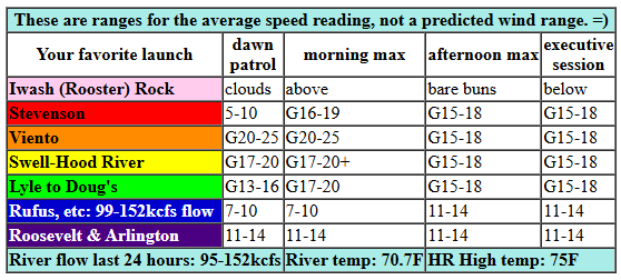
Let’s take a look at the forecast: Monday started with pressures of 29.94/29.86/29.84 for gradients of 0.08 (PDX-DLS) and 0.02 (DLS-PSC). With a disturbance overhead and forecast to move through, and with instability present all day, the wind will be lighter, gustier, and less reliable than it has been lately. Ensembles of the Euro and the GFS deterministic are giving conflicting information: the GFS has us at 10-13mph all day between Stevenson and Avery while the Euro calls for 18-21 from Stevenson to Avery and the HRRR (really digging in deep today!) has the wind at 14-17 from Stevenson to Celilo.
Let’s call it gusty, up-and-down 17-20 from Viento to Swell early with 13-16 from Mosier to Doug’s and less than 10mph east of Doug’s. Stevenson: less than 10mph for the morning. As this system moves east this morning, a brief period of stronger wind, perhaps 5mph stronger, is likely between Stevenson and Avery. Afternoon wind is a bit trickier as instability increases. How about gusty 15-18 from Stevenson to Avery with 11-14mph to the east? Any thunderstorms that arise will render this forecast moot. River flow over the last 24 hours was 95-152kcfs (99-152kcfs at Rufus), river temp is 70.7F, and high temp forecast is 75F.
RIVER FLOW FOR SITES BETWEEN AVERY (EAST OF THE DALLES) AND RUFUS: CLICK HERE FOR JOHN DAY DAM FLOW.
RIVER FLOW FOR SITES BETWEEN STEVENSON AND DOUG’S BEACH (WEST OF THE DALLES): CLICK HERE FOR THE DALLES DAM FLOW

tomorrow’s gorge wind forecast
Instability sticks around on Tuesday, and that makes for another tricky forecasting day. For now, let’s call it 14-17mph to start the day from Stevenson to Arlington. Westerlies rise to 17-20mph between Stevenson and Mosier mid-morning and fill in as far east as Rowena in the afternoon. East of Rowena, afternoon wind will be 11-14mph. Once again, any thunderstorms will have an impact on the wind speed, quality, and reliability. High temp: 85F.
extended Gorge wind forecast
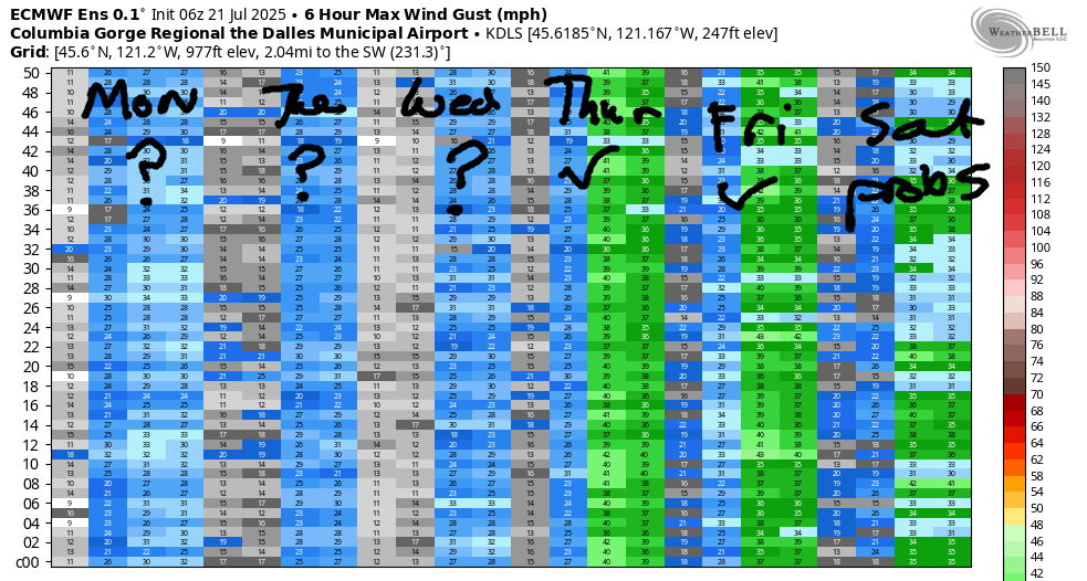
Heat builds across the region on Wednesday and knocks the wind speed down. The day starts with 11-14 from Viento to Swell, drops below 10mph midday, and returns in the afternoon. For the afternoon, we’re currently looking at 14-17mph from Stevenson to Hood River, 17-20 from Mosier to Avery, and 14-17mph at Rufus. High temp: 90F. Looking deeper into the future… cooler air from the NW swings around an offshore high and sets us up for better cross-Cascade temp gradients starting Thursday or Friday. Models gives us 20-25mph average speeds for Thursday, Friday, and Saturday. Uncertainty increases on Sunday, but we should still see 17-20mph or more. That’s all for now. Keep the folks affected by the Burdoin Fire in your hearts as you play on the river, and please avoid any launch sits within the fire zone per the request of the incident management team.
JONES BEACH, SAUVIE ISLAND, & COAST FORECAST
Wind northerly unless otherwise indicated. For coast, it’s North/Central/South with the “central” at approximately Florence. Swell forecast from NWS for central coast. Jones: westerly unless otherwise stated. Sauvie Island: northerly unless otherwise stated. Coast Monday: LTNW/LTNW/N15-20, NW swell 3′ at 13 seconds. Tuesday: NW5-10/N15-20/N20-25, NW 3′ @ 12. Wednesday: NW10/NNW10/N10-15, NW 3′ @ 114. Jones Monday: 15-18. Tuesday: 13-16. Wednesday: 16-19. Sauvie Island Monday: 8-11. Tuesday: 9-12. Wednesday: 10-13.
BARE BONES HOOD RIVER WEATHER FORECAST
Clouds and some light drizzle this morning give way to partly cloudy sky and a slight chance of thunderstorms this afternoon. Temps start near 60 and climb to the mid 70s. Light westerlies. 4% chance of rainbows. Tuesday will be partly cloudy then clear. Temps start in the mid 50s and rise to the mid 80s. Moderate westerlies. No rainbows. Wednesday will be mostly clear. Temps start near 60 and rise to 90. Moderate westerlies. No rainbows.
TEMIRA’S AWESOME TRAVEL ADVISORY SERVICE – MONDAY 7/21
HYPERLOCAL WEATHER FORECAST FOR THE COLUMBIA GORGE
THE DALLES, HOOD RIVER, WHITE SALMON, TROUT LAKE, STEVENSON, CASCADE LOCKS, PARKDALE, ODELL, HUSUM, BZ, MILL A, WILLARD, GOLDENDALE, RUFUS, ARLINGTON, boardman
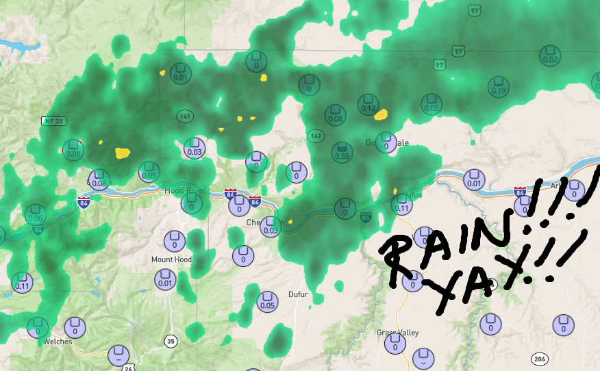
Good morning, neighbors! The most amazing thing happened last night: IT RAINED! While we didn’t get a ton of rain on the fire, we did get some. But check this out: parts of the metro area got half an inch of rain. Wow. Send some of that our way, please! Humidity is up this morning, and wind speeds are down. The fire remains 0% contained and is over 10,000 acres, but we have better weather for fighting it for the next few days – less wind, notably, through Wednesday. Before we dive in…
GLENWOOD THIS MORNING
Glenwood was drizzly (I think – I’m guessing) this morning with a 48 degree start. While that’s not cold enough for snow by any means, it is a chilly start when mist is falling. Everyone in the little hamlet is thanking Ma Nature today on behalf of Glenwood and everyone affected by fire. You too can take a moment to express gratitude in whatever way feels fit to you – gratitude first thing in the morning will get your day off on a good note. Promise!
TODAY’S GORGE WEATHER FORECAST
In a fun and calming change from recent weather, we’ll have a cloudy morning. These clouds start to burn off in the afternoon, but instability causes other kinds of clouds to form. We have a slight chance of thunder today focused on the Cascade Crest (or was it the Cascade Aquafresh? I can’t remember.) and areas just east of the crest/Aquafresh. The GFS model has the eastern edge of the Burdoin fire within the highest possibility for convective showers. Fingers crossed! Temps today rise to the mid 70s (west), low 80s (The Dalles) and upper 70s (out in the desert). Wind models are all over the place, so the wind forecast won’t be super reliable. I’m going with 15-20mph between Viento and White Salmon this morning with 15-20mph from Stevenson to Avery this afternoon.
TUESDAY’S GORGE WEATHER FORECAST
Tuesday sees this weather system shift east. Know what will stick around for the day? Humidity. Expect a muggy one for these parts as dewpoints hold at 50-55 degrees. We start the day with low clouds in the west and clear sky to the east. Afternoon brings another round of instability, little fluffy clouds, and thunderheads. Rain chances are less than on Monday. Highest chances: near Goldendale, which seems to attract thunderstorms like big, round butts attract TATAS. Wind will be 15mph to start between Stevenson and Arlington.. Afternoon wind rises to 15-20mph between Stevenson and The Dalles and drops to 10-15mph east of The Dalles. High temps will be 85 (west) to 90 (The Dalles and areas to the east).
EXTENDED GORGE WEATHER FORECAST
Even less wind is forecast for much of Wednesday, but hotter temps are also forecast. We’ll have mostly clear sky all day. A few convective clouds pop up in the afternoon east of The Dalles where instability will linger. Wind will be 10mph early west of Mosier. Afternoon: 15, maybe 20mph between Mosier and Avery with 15mph to the west of Mosier and 15mph east of Avery to Rufus. It’ll be too hot for TATAS: 90 (west) and 95 (The Dalles and areas to the east).
Looking towards the end of the week, we see temps drop a few degrees. As that happens, the west wind surges back. From this vantage point, we’re looking at 20-25mph each day west of The Dalles and potentially for areas to the east. That’s all I got for now. I woke up late today, so I”m going to go get this forecast out. Be kind to each other. Safe travels. -TATAS
HEY! DON’T STOP READING! Is this community-focused forecast helpful to you? It sure is! It takes me a couple hours a day to write. Please join your friends and neighbors in contributing to keep it going. Venmo: @thegorgeismygym PayPal: twomirrors@gmail.com USPS: Temira / PO Box 841 / Hood River, Oregon 97031 You can test out the forecast subscription for a few days for free by signing up below. Easy! Do it!
