

GORGE WIND FORECAST
today’s gorge wind forecast
Hi friends! That was quite the day yesterday, wasn’t it! Hopefully everyone reading this got some of the fun. Our next chance for big wind like that in the Gorge wind forecast is Wednesday evening in the Corridor and Thursday out east. That’s followed by another shot late next weekend or maybe at the start of the following week. In between those days, we have a short-lived heat wave that will turn the wind easterly for about 36 hours. Let’s take a look at the deets, shall we?
Monday opens up with a weak weather system moving from west to east. Pressures at 6am were 30.06/30.01/29.97 for gradients of 0.04/0.04. That’s pretty minimal, and the wind reflects that: at daybreak, it was below 15mph at all our usual windsport spots. After a slow start today, westerlies pick up late morning or early afternoon. Near the Corridor, persistent clouds are likely to result in a poor showing; you’ll want to head east of Hood River for best results. Not much happens before 11am today.
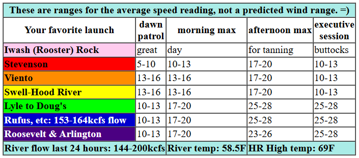
After that, with thermal assistance, the Stevenson-Hood River (or maybe Mosier, depending on the clouds) zone rises to 17-20mph. After 5pm, it drops back below 15mph. After 11am, the Lyle-Rufus zone rises to 25-28. Arlington, Threemile, and Boardman join at 23-26 after 5pm. It’s worth a reminder that this forecast predicts wind speeds on the iWind/iKite sensors; yesterday’s reading at Swell was 28mph. That’s equivalent to about 33mph on the sensors east of The Dalles. In other words, the forecast for 25-28mph out east today is about the same as a 21-24mph reading at Swell. Gosh, wind sports are complicated! River flow over the last 24 hours was 144-200kcfs, river temp is 58.5F, and high temp forecast is 69F for Hood River and 72F for Arlington.

tomorrow’s gorge wind forecast
High pressure builds inland on Tuesday and turns the wind weakly offshore, aka easterly. The day starts dead calm. By late morning easterlies rise to 15mph at both Stevenson and Iwash (Rooster) Rock as well as at Viento. The wind drops to 10mph in the afternoon at those spots and rises to 5-10mph from Hood River eastward. High temp: 82F and mostly sunny.
extended Gorge wind forecast
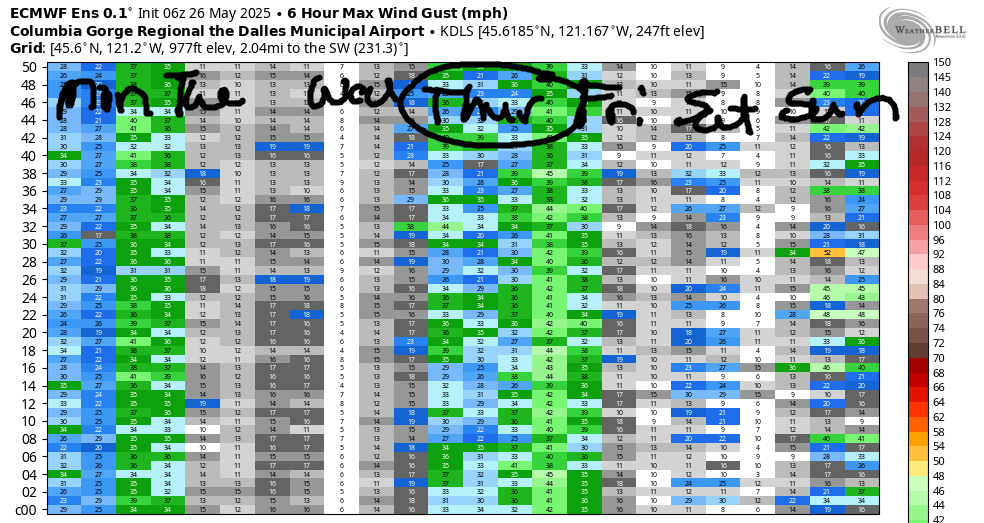
Wednesday starts with inland high pressure and offshore wind. Early easterlies will be 20-25mph at Stevenson and 15-20mph at both Iwash and Viento. The wind goes calm (briefly) midday. Depending on the timing of an approaching front, we could see a late-day blast in the Corridor. Timing will be everything, but as of now, 25+mph looks possible between Stevenson and Avery late in the day. Looking out deeper into the future… ensembles give us a moderately-strong to strong day on Thursday, probably out east. Not much happens Friday, but there’s potential for a late strong blast on Saturday. Or maybe that will wait until Sunday. Ensembles are very excited about wind potential late Saturday into Monday. Fingers crossed. See you on the Nch’i Wana!
Was that helpful? I knew it was! Guess what? All of this crucial work – from your personal wind and snow reports to the invaluable TATAS updates – is made possible by my relentless efforts. Maintaining this labor of love isn’t easy. Each daily forecast takes hours. Website hosting, weather model access, and back-end admin work takes time and money. That’s where you come in.
YOUR CONTRIBUTION MAKES A DIFFERENCE
- SUPPORT ACCURATE, HYPER-LOCAL WEATHER FORECASTING
- ENABLE ACCESS FOR ALL, EVEN THOSE WITH LESS MEANS
- SUPPORT A COOL HUMAN WHO WORKS HARD SO YOU CAN PLAY
Take a moment to click one of the buttons below. Donate $19.99 or more (how much does this forecast enhance your life?) and get the email in your inbox. Whether it’s a renewing subscription (auto-renew) or a one-time donation, every contribution makes a real difference. Help me keep this labor of love alive, so we can all continue playing, commuting, and living in the Gorge with peace of mind and the best weather forecasts possible. Thank you!


Hood River, Oregon 97031


JONES BEACH, SAUVIE ISLAND, & COAST FORECAST
Wind northerly unless otherwise indicated. For coast, it’s North/Central/South with the “central” at approximately Florence. Swell forecast from NWS for central coast. Jones: westerly unless otherwise stated. Sauvie Island: northerly unless otherwise stated. Monday: LTW/LTW/N20-25, W swell 6′ at 11 seconds and SW 2′ @ 17. Tuesday: 20/20/25, W 5′ @ 10 and SW 2′ @ 16. Wednesday: LTW/LTW/LTV, W 6′ @ 11 and SW 2′ @ 16. Jones Monday/Tuesday: LTW. Wednesday: 23-26. Sauvie Island Monday: 11-14. Tuesday: 13-16. Wednesday: 16-19.
BARE BONES HOOD RIVER WEATHER FORECAST
Mostly cloudy sky this morning turns mostly clear then adds some high clouds. Temps start in the upper 50s and rise to the upper r60s. Moderate westerlies. No rainbows. Tuesday will be partly high cloudy / mostly clear. Temps start in the upper 40s and rise to the lo w80s. Calm wind early. Light easterlies later. No rainbows. Wednesday will be sunny. Temps start in the mid 50s and rise to 90 degrees. Light easterlies in the morning. Strong westerlies in the evening. No rainbows.
TEMIRA’S AWESOME TRAVEL ADVISORY SERVICE
HYPERLOCAL WEATHER FORECAST FOR THE COLUMBIA GORGE
THE DALLES, HOOD RIVER, WHITE SALMON, TROUT LAKE, STEVENSON, CASCADE LOCKS, PARKDALE, ODELL, HUSUM, BZ, MILL A, WILLARD, GOLDENDALE, RUFUS, ARLINGTON, boardman

Good morning, neighbors! Well, after all my chatter about the weather being not-hot, we have a couple of rather warm days in the next week: Wednesday and potentially Saturday – both of those could touch or exceed 90 degrees. Other than those, temps bounce around all over the place. There’s some hint of cooler weather at the end of next weekend, but there’s also a 15 degree spread in the high temp possibilities. Rain? Just a little today west of Hood River and possibly a little next Thursday in the same zone.
our friends in glenwood this morning
Checking in with Glenwood this morning, we have a bunch of nice country people enjoying coffee on the deck with a mild morning at 53 degrees. We’re just three weeks out from the Ketchum Kalf Rodeo, and it’s a big year. This is year 90! Wow! Mark your calendar for June 13-15.
monday’s gorge weather forecast
Back to today… Nice day on tap. After a partly cloudy start (west) and mostly sunny start (east), we end up mostly clear and then add some high clouds. Temps make it to 69 (the most confusing temp) in the west and low 70s to the east. Westerlies rise to 25-30mph east of Hood River and hang at 15-20mph west of Mosier. Drizzle west of Wyeth sticks around until early afternoon, and then we’ll all be dry. Like saltines. They’re really dry.
tuesday’s gorge weather forecast
High pressure builds inland on Tuesday. In response, the hottest temps set up over the Valley Of Willies (VOW), resulting in all those city folks melting into puddles. When city folk melt, they turn into concrete. This results in a feedback loop where more and more city folk melt and more and more concrete forms and temps get ever hotter in the city. This is a great reason to live in the country like we do. Anyway, around here, temps rise to the low 80s (west) and upper 70s (east). Wind will be calm as a clam to start (clams are calm because you can rearrange the letters to spell “calm”). Wind speeds climb to E 15mph between Iwash (dick) Rock and Viento and eventually build to E 5-10mph east of Viento out in to the desert, where the tumbleweeds will take one look at 5-10mph wind and refuse to move. Strike that. I just asked Claude, and it says tumbleweeds can move in 3-5mph “if the ground is smooth”. That’s amazing!
wednesday’s gorge weather forecast
Wednesday brings our first 90 degree weather of the year. Boo hiss to that. TATAS will melt like a city folk. The day starts clear and mid 50s with east wind at 20mph in the usual east wind spots (west of Hood River). Midday, the wind goes calm. Depending on the timing of some shit and stuff happening to the west of us, we could see super-strong west wind near Hood River in the evening. Even if it doesn’t arrive before sunset, it will arrive overnight. Secure your rubbish bin.
extended gorge weather forecast
Looking out into the far future… Thursday looks cool and breezy. Friday and Saturday look warm (85+ degrees) and not so breezy. Model agreement then falls apart on Sunday. Everything depends on how the cooldown happens and how strong the happenings are. If you like TATAS and apprecite them and want them to have lots of conditional joy and good times with friends, please vote for a massive cooldown accompanied by offshore high pressure and a heat low in the desert. TATAS is a Wind Johnny, and TATAS likes strong wind. Safe travels. -TATAS
HEY! DON’T STOP READING! Is this community-focused forecast helpful to you? It sure is! It takes me a couple hours a day to write. Please join your friends and neighbors in contributing to keep it going. Venmo: @thegorgeismygym PayPal: twomirrors@gmail.com USPS: Temira / PO Box 841 / Hood River, Oregon 97031 You can test out the forecast subscription for a few days for free by signing up below. Easy! Do it!
