

GORGE WIND FORECAST
today’s gorge wind forecast
Hi friends! It’s Monday, and we have a windy week on tap. Uncertainty rears its head for the weekend with a questionable day on Saturday and hot, not-windy weather likely for Sunday and potentially Monday. After 1-3 days of heat, we’ll fall right back into a west wind pattern when the cooldown arrives. Cross your fingers for The Cooldown You’ve Been Looking For!
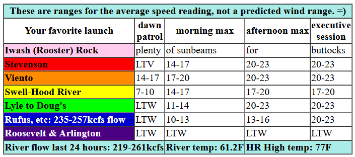
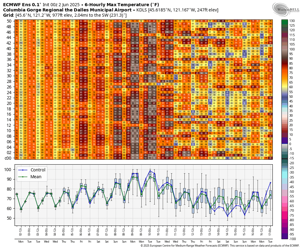
Monday starts off with pressures of 30.27/30.21/30.19 and clear sky in the metro area. A weak system is forecast to move through today, but it won’t do much other than add high clouds; we’re relying on offshore high pressure and desert heat. The day started with light/variable wind. By late morning, we’ll have 14-17 from Stevenson to Mosier. In the afternoon, Stevenson-Doug’s rises to 20-23. Swell is likely to be a bit lighter with 17-20, although a short period of 20-23 late morning to early afternoon can’t be ruled out. Rufus joins in the evening. River flow over the last 24 hours was 219-261kcfs, river temp is 61.2F, and high temp forecast is 77F with sunshine all day.

tomorrow’s gorge wind forecast
Models suggest low clouds for the metro area on Tuesday morning. Robust offshore high pressure persists. If this pans out, we’ll have a stronger day than Monday thanks to a beefier thermal gradient. Dawn Patrol kicks off with 21-24 from Viento to Mosier with 10-13 at (cloudy?) Stevenson, 17-20 between Lyle and Doug’s, and 7-10 to the east. Midday wind rises to 25-28 from Stevenson to Avery with 20-23 at Rufus. Between Mosier and Rufus, westerlies rise to 27-31 from mid-afternoon on. Arlington joins for the Executive Session, after 5pm. High temp: 78F and partly high cloudy.
extended Gorge wind forecast
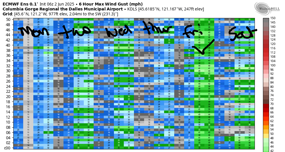
Westerlies continue on Wednesday with a 20-23mph start near the Hatch and a 24-27 finish between Stevenson and Doug’s with Rufus and Arlington joining in the evening. Thursday looks similar but potentially a little stronger. It’s worth noting that there’s some hint each day, Monday through Thursday, of Corridor wind fading in the afternoon. Ensembles have Friday pegged as the strongest day of the bunch, and the GFS deterministic maintains the strong wind wind in the Corridor (Swell to Hood River) into the evening. So, we’ll cross our fingers for that!
For those of you who need to plan well in advance… let’s take a look at the weekend. As of this morning, Saturday is 50/50 for westerlies thanks to the potential for ridging; models have a ten degree spread in possible high temps. That’s a lot of uncertainty. About 30% of the ensemble members have wind on Sunday, but they’re all agreeing on hot weather Sunday and Monday with about a 10 degree spread in possible high temps. Uncertainty increases after the weekend – generally speaking the weather is forecast to turn cooler, but the range of possible outcomes is huge with 10-15 degrees of spread in the ensembles. Translating to simple language: there’s really too much uncertainty to make a call for the weekend yet, but Sunday/Monday are the least likely west wind days of the next ten. Hope that’s helpful! Have a great day out there on the Nch’i Wana today!
Was that helpful? I knew it was! Guess what? All of this crucial work – from your personal wind and snow reports to the invaluable TATAS updates – is made possible by my relentless efforts. Maintaining this labor of love isn’t easy. Each daily forecast takes hours. Website hosting, weather model access, and back-end admin work takes time and money. That’s where you come in.
YOUR CONTRIBUTION MAKES A DIFFERENCE
- SUPPORT ACCURATE, HYPER-LOCAL WEATHER FORECASTING
- ENABLE ACCESS FOR ALL, EVEN THOSE WITH LESS MEANS
- SUPPORT A COOL HUMAN WHO WORKS HARD SO YOU CAN PLAY
Take a moment to click one of the buttons below. Donate $19.99 or more (how much does this forecast enhance your life?) and get the email in your inbox. Whether it’s a renewing subscription (auto-renew) or a one-time donation, every contribution makes a real difference. Help me keep this labor of love alive, so we can all continue playing, commuting, and living in the Gorge with peace of mind and the best weather forecasts possible. Thank you!


Hood River, Oregon 97031


JONES BEACH, SAUVIE ISLAND, & COAST FORECAST
Wind northerly unless otherwise indicated. For coast, it’s North/Central/South with the “central” at approximately Florence. Swell forecast from NWS for central coast. Jones: westerly unless otherwise stated. Sauvie Island: northerly unless otherwise stated. Monday: 20-25/25/35+, N swell 9′ at 8 seconds and W 3′ @ 12. Tuesday: 10-15/15-20/35+, N 4′ @ 6 and W 2′ @ 12. Wednesday: 15-20/20/30-35, NW 6′ @ 7 and W 3′ @ 13. Jones Monday: 20-23. Tuesday: 21-24. Wednesday: 12-15. Sauvie Island Monday: 17-20. Tuesday: 15-18. Wednesday: 11-14.
BARE BONES HOOD RIVER WEATHER FORECAST
Clear sky today. Temps start in the upper 40s and rise to the upper 70s. Moderate westerlies. No rainbows. Tuesday will be partly cloudy then partly high cloudy. Temps start near 50 and rise to the upper 70s. Moderate to strong westerlies. No rainbows. Wednesday will be cloudy then clear. Temps start in the low 50s and rise to the mid to upper 70s. Moderately strong westerlies. No rainbows.
TEMIRA’S AWESOME TRAVEL ADVISORY SERVICE
HYPERLOCAL WEATHER FORECAST FOR THE COLUMBIA GORGE
THE DALLES, HOOD RIVER, WHITE SALMON, TROUT LAKE, STEVENSON, CASCADE LOCKS, PARKDALE, ODELL, HUSUM, BZ, MILL A, WILLARD, GOLDENDALE, RUFUS, ARLINGTON, boardman
Good morning, neighbors! Summery weather continues through this week with temps hovering right around 80 most days. Bare-ass naked tanning at Iwash (dick) Rock is going to be off the charts! Get some! As we move into the weekend, the weather gives us the big ol’ middle finger with 90+ degrees of heat for 2-3 days. Some of you are excited about this. I am excited for you! Things cool back down by the middle of next week, but there’s so much uncertainty that there’s nothing to hang a hat on… except your head. Hang a hat there to protect yourself from day after day of sunshine.
monday morning Gorge weather forecast and Glenwood’s start. Surprise community guest today!
It’s currently Monday morning, and hopefully it’ll stay Monday all day. Our friends in Glenwood (and High Prairie, where the men are gingers and the electricity is generated by solar panels) had a chilly start with 34 degrees. Don’t worry – no tomatoes were harmed by this weather. I hope.
Temps rapidly rise to the mid-upper 70s all across the land today, ripening the pie cherries and encouraging the Atlantic Giants (in particular the 2085 Toboyek and 2453 Sherwood and 1640 Lital) to grow big and wide. West wind picks up to 20-25mph between Stevenson and The Dalles this afternoon. Rufus joins the breezy club this evening with both a bit of wind and all sorts of cheerful, brisk, friendly patter on topics both weather-related and otherwises. You’ll find Rufus pontificating at Bob’s Texas T-Bone, which is a great name for a restaurant. BTTB has 4.3 stars on Google and opens at 6am. 6am?!?! Next time I need an early morning steak, I know where to go!
Tuesday, wednesday, thursday, friday, etc. Gorge weather forecast
To be perfectly honest, we don’t need paragraphs of text for the rest of the week; the weather for Tuesday, Wednesday, and Thursday looks nearly identical to Monday’s weather. Friday looks windier. Ensembles for Saturday are warmer than the rest of the week, but there’s a 10 degree range in the possible outcomes: 80-90 degrees and windy/not windy. The intraquartile range, a term only out-awesomed by “irrational exuberance”, gives us 89-97 degrees for Saturday and 91-98 degrees for Sunday. Monday: 79-92. Too much uncertainty in any of those days to accurately make predictions.
One thing I can say for sure: other than the possibility of a few lonely raindrops near Cascade Locks on Wednesday morning, there’s no sign of rain for us in the next 10 days. And remember that rain is not allowed between June 15th and July 15th in order to protect the cherry crop. So it’s going to be very dry around here for quite a while. Given the wind this week, please consider postponing any burning, and please consider doing all spark-causing stuff early in the morning when 1) humidity is higher and 2) the wind is lighter. Mahalo for your kokua. Safe travels. -TATAS
HEY! DON’T STOP READING! Is this community-focused forecast helpful to you? It sure is! It takes me a couple hours a day to write. Please join your friends and neighbors in contributing to keep it going. Venmo: @thegorgeismygym PayPal: twomirrors@gmail.com USPS: Temira / PO Box 841 / Hood River, Oregon 97031 You can test out the forecast subscription for a few days for free by signing up below. Easy! Do it!
