

GORGE WIND FORECAST
If you’re still seeing yesterday’s and it’s after 9am, try opening this in an incognito window
today’s gorge wind forecast
Hi friends! Looks like we’ll have westerlies today and early tomorrow before we drop into another round of east wind on Wednesday. Thursday and Friday bring light/variable wind, weather conducive to you getting all that outside stuff done.
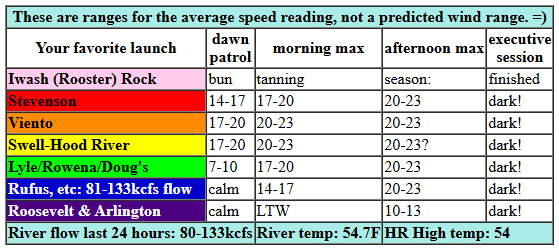
Monday morning started with pressures of 29.74/29.67/29.70 for gradients of W0.07 and E 0.03. We’re expecting 19-22mph from Viento to the Hatch mid-morning with 15-18mph at Stevenson and 15-18mph from Hood River to Avery. Afternoon wind rises to 20-23mph from Stevenson to Rufus. River flow over the last 24 hours was 80-133kcfs, river temp is 54.7F, and high temp forecast is 54F with increasing sunshine.
RIVER FLOW FOR SITES BETWEEN AVERY (EAST OF THE DALLES) AND RUFUS: CLICK HERE FOR JOHN DAY DAM FLOW.
RIVER FLOW FOR SITES BETWEEN STEVENSON AND DOUG’S BEACH (WEST OF THE DALLES): CLICK HERE FOR THE DALLES DAM FLOW

tomorrow’s gorge wind forecast
Tuesday starts off with westerlies, but building high pressure shuts them down quickly. Early in the morning we could see as much as 17-20mph from Viento to the Hatch with 13-16mph from Hood River to Mosier and 10-13mph east of Mosier. Afternoon wind drops to 13-16mph and fills in from Stevenson to Hood River. East of Hood River, the wind falls below 10mph by late morning. Afternoon wind drops below 10mph all through the gorge. High temp: 50F and partly cloudy.
extended Gorge wind forecast
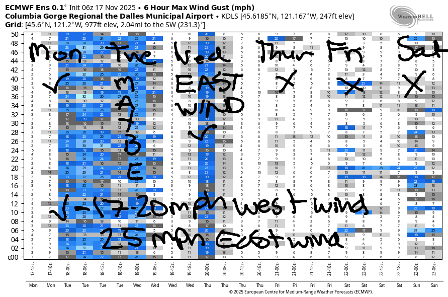
Wednesday sees high pressure build inland. Cool air lingers in the desert all day, and this drives the wind speeds up as the day progresses. Early morning starts light easterly. By midday, we’ll have east wind at 35-40mph at Iwash (Rooster) Rock, 30-35mph near Stevenson, and 25mph near Viento with 10-15mph east of Hood River. Afternoon wind falls to 30-35mph at Iwash and 25-30mph at Stevenson. High temp: 50F under partly high overcast sky.
Thursday’s forecast is currently for light/variable wind. On Friday, we’re looking at light westerlies. Models keep the light/variable wind going through Saturday and potentially through Sunday. That’s all I’ve got for you for now. Hope to see you on the Nch’i Wana!
Was that helpful? I knew it was! Guess what? All of this crucial work – from your personal wind and snow reports to the invaluable TATAS updates – is made possible by my relentless efforts. Maintaining this labor of love isn’t easy. Each daily forecast takes hours. Website hosting, weather model access, and back-end admin work takes time and money. That’s where you come in.
YOUR CONTRIBUTION MAKES A DIFFERENCE
- SUPPORT ACCURATE, HYPER-LOCAL WEATHER FORECASTING
- ENABLE ACCESS FOR ALL, EVEN THOSE WITH LESS MEANS
- SUPPORT A COOL HUMAN WHO WORKS HARD SO YOU CAN PLAY
Take a moment to click one of the buttons below. Donate $19.99 or more (how much does this forecast enhance your life?) and get the email in your inbox. Whether it’s a renewing subscription (auto-renew) or a one-time donation, every contribution makes a real difference. Help me keep this labor of love alive, so we can all continue playing, commuting, and living in the Gorge with peace of mind and the best weather forecasts possible. Thank you!


Hood River, Oregon 97031


MT HOOD SNOW FORECAST

Hey skiers and snowboarders! Looking back to the forecast from a week or so ago, models told us that today was the start of a cooler, wetter, accumulating-snow type of pattern. That seems to have changed. Not much, if any, snow is in the forecast this week. Models now point at NEXT Monday as the start of a cooler weather pattern. Given what I’m seeing in the models, it appears unlikely that we’ll have any riding other than Timberline open by Thanksgiving. Alas… we’ve been lucky for the last couple of years, but not every year has early-season dumpage!
Looking at Mt. Hood today, we have a little drizzle, 0.1”, in the morning as the snow level starts at 7000′ and falls to 6000′ this afternoon. While the freezing level will dip as low as 2000′ briefly overnight near Mt. Hood, there won’t be much if any precip to go along with it. Wind today: light south early, SW 10-15 this afternoon, and NW 25 after midnight, which could result in a few orographic snow flurries but no significant accumulation at 5000′.
Tuesday will be sunny (maybe a few orographic clouds/flurries early), then cloudy, then clear again overnight. The freezing level bounces around early with pockets of cold and warm air competing for dominance. By afternoon, the freezing level will be at 3500′. It drops to 2500′ after midnight. Wind will be NW 25 early, variable to 10 in the afternoon, and E 5-10 overnight. Wednesday: partly cloudy with light wind. The free air freezing level rises from 2500′ to 8000′ and drops back to 5500′ after midnight. Thursday: there’s some disagreement in the models – about 50% bring in up to 0.25” precip, but the others do not. After that, most of the ensembles hold off on moisture until Sunday, and they keep temps too warm for snow at 5000′ until next Monday. All right. That’s what I have for you this morning. Have a great day today!
TEMIRA’S AWESOME TRAVEL ADVISORY SERVICE
HYPERLOCAL WEATHER FORECAST FOR THE COLUMBIA GORGE
THE DALLES, HOOD RIVER, WHITE SALMON, TROUT LAKE, STEVENSON, CASCADE LOCKS, PARKDALE, ODELL, HUSUM, BZ, MILL A, WILLARD, GOLDENDALE, RUFUS, ARLINGTON, boardman

Good morning, neighbors! So much comedic material in the news today. Thank goodness the weather remains nonthreatening so we can spend a little time sussing out what’s going on. I am pretty certain that we’ve entered an alternate universe. Let’s look at the weather, first: a little drizzle this morning (it’s Monday) gives way to dry weather Tuesday and Wednesday as high pressure builds. On Thursday, we might or might not have a little rain. Friday and Saturday are likely to be dry. After that: increasingly uncertainty as the weather (probably) turns cooler and (probably) turns wetter.
Glenwood this morning
Checking in with Glenwood this morning… it’s 43 degrees and cloudy, and everyone named Bubba is vocally denying that they are in the Epstein Files. Just a gentle reminder: if you’re more upset about Trump potentially giving a man a BJ than you are about him having sex with female teenagers, you may want to revisit your moral compass. Next up, everyone named Bubba is practicing saying, “I did not have sexual relations with that man, Donald Trump,” while Donald Trump is practicing saying, “I did not have sex with that man (or horse), Bubba.” Know what else he’s up to: trying to remove DNA evidence from his blue suit.
OH FOR THE LOVE OF BUBBA, WHAT UNIVERSE ARE WE LIVING IN?!??!?!
Today’s Gorge weather forecast
Let’s avert our eyes and our minds from those horrifying images and move on to today’s weather. Clouds in the morning give way to partly cloudy weather this afternoon. Thanks to the clouds, temps were generally mild this morning. Thanks to the fact that it’s November, temps max out in the mid 50s (west) and upper 50s (The Dalles and eastward) this afternoon. West wind rises to 20mph or so between Stevenson and Rufus by this afternoon, which creates a froth of boardheads (a “froth” is a term for lots of Wind Johnnies, aka boardheads) dashing around seeking whitecaps.
Tuesday’s Gorge weather forecast
High pressure builds in overnight and leaves us mostly cloudy to start Tuesday. Temps fall into the upper 30s near the Nch’i Wana and below freezing many places away from it. Clouds penetrate the Gorge west of Mosier mid-morning like Bubba’s Iwash penetrating the president’s mouth. Clouds break up in the afternoon like MTG and DJT having a falling out. Also: what universe are we living in where MTG says, “I just want people to be kind to each other”?!?!?! I feel dizzy. Anyway, on Tuesday afternoon, we’re all left mostly clear. Wind will be 15-20mph west of Mosier in the morning and less than 10mph all through the Gorge in the afternoon.
Wednesday’s Gorge weather forecast
Ridging (dry, clear) persists on Wednesday and sets us up for a near-river Nothing on Wednesday. By afternoon, the Nothing breaks, but high clouds move in from the west in a piss-poor attempt to replace the Nothing. The sun shall triumph and shine through these clouds, giving us the impression we’re on TV, where the sun always shines. Wednesday morning temps will be in the mid 30s near the Nch’i Wana. They’ll be sub-freezing away from it where there’s clear sky, except where it’s windy. Those breezy spots will likely stay above freezing. Wind: light easterly in the morning. East 30-40mph at Iwash (RELEASE THE FILES) Rock in the afternoon with 30mph near Stevenson, 20mph near Viento, and 10-15mph east of Viento out into the desert. High temps: 50ish degrees, give or take a couple.
Extended Gorge weather forecast
Models haven’t decided if it’ll rain or stay dry on Thursday. Uncertainty: the spice of life. Models do predict light/variable wind and high temps near 50. Ditto for the temps and wind on Friday. Saturday: increasing uncertainty about moisture – that’s what happens, by the way, when people with vag*nas get older. I speak from experience. Moisture chances do increase as we move deeper into next weekend. Okay. That’s it for now. I’m going to see if I can find a froth of boardheads to join. Safe travels. -TATAS
HEY! DON’T STOP READING! Is this community-focused forecast helpful to you? It sure is! It takes me a couple hours a day to write. Please join your friends and neighbors in contributing to keep it going. Venmo: @thegorgeismygym PayPal: twomirrors@gmail.com USPS: Temira / PO Box 841 / Hood River, Oregon 97031 You can test out the forecast subscription for a few days for free by signing up below. Easy! Do it!
JONES BEACH, SAUVIE ISLAND, & COAST FORECAST
ON WINTER VACATION UNLESS DESPERATELY NEEDED.
