

MT. HOOD WEATHER FORECAST
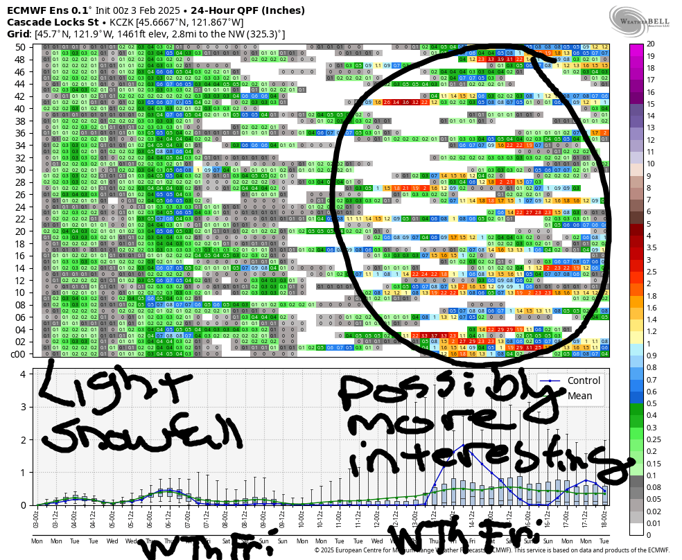
Hey skiers and snowboarders! Remember how the season started with the snow level bouncing around and rain alternating with snow? We’ll have none of that this week – temps stay cold, and we’ll pick up a few inches of snow here and there. Next chance for more significant snowfall comes next weekend, but it’s not a sure thing yet. In the meantime, we should see decent packed powder and hardpack groom with skier-packed powder off piste. Nordic: it’s going to be a blue wax week, great for you classic skiers and a lot of work for you skaters!
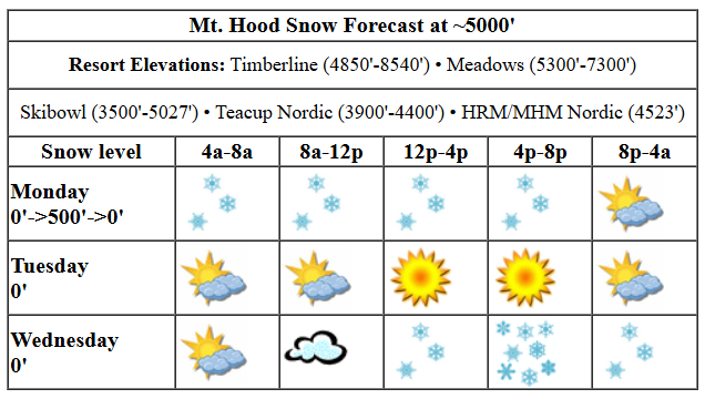
Between yesterday and today (it’s Monday), Ma Nature added another 6” of powder to the snowpack. That mostly fell during the day yesterday. Today we’ll pick up maybe an inch or two of additional powder. The snow level near Mt. Hood will be 0-500′ all day (it’s snowing at my house as I write this), and temps at 5000′ will be in the upper teens to low 20s. Wind: WSW 10-15 all day and WSW 5-10 after midnight.
Liking this forecast?
A dry day is forecast on Tuesday with partly cloudy sky in the morning, sunshine in the afternoon, and partly cloudy sky overnight. Temps will be in the low double digits in the morning and upper teens later with the free air freezing level at 0′ all day. Wind: variable to 10mph during the day and WSW 15mph after midnight.
Wednesday starts partly cloudy and turns snowy by mid-morning. The snow level near Mt. Hood will be 0′ with temps near 20F all day. About 0.2” water equivalent (WE) is forecast during the day for 2-3” powder. Overnight: another inch of new. Wind will be WSW 15 in the morning, SSW 15-25 in the afternoon, and light SW overnight.
Cloudy weather with flurries and increasing east wind is forecast for Thursday. A couple inches of snow is possible Thursday night into Friday from easterly orographic precipitation. The snow level will be 0′ all day Thursday with temps in the mid teens at 5000′. There’s a relatively wide range of precipitation possibilities for next weekend, so I’ll leave this here for now. See you on the snow!
Was that helpful? I knew it was! Guess what? All of this crucial work – from your personal wind and snow reports to the invaluable TATAS updates – is made possible by my relentless efforts. Maintaining this labor of love isn’t easy. Each daily forecast takes hours. Website hosting, weather model access, and back-end admin work takes time and money. That’s where you come in.
YOUR CONTRIBUTION MAKES A DIFFERENCE
- SUPPORT ACCURATE, HYPER-LOCAL WEATHER FORECASTING
- ENABLE ACCESS FOR ALL, EVEN THOSE WITH LESS MEANS
- SUPPORT A COOL HUMAN WHO WORKS HARD SO YOU CAN PLAY
Take a moment to click one of the buttons below. Donate $19.99 or more (how much does this forecast enhance your life?) and get the email in your inbox. Whether it’s a renewing subscription (auto-renew) or a one-time donation, every contribution makes a real difference. Help me keep this labor of love alive, so we can all continue playing, commuting, and living in the Gorge with peace of mind and the best weather forecasts possible. Thank you!


Hood River, Oregon 97031


GORGE WIND FORECAST

Hi friends! Cold weather and east wind is what you get through at least Thursday. Not much at all happens for Monday – pressures were 29.88/29.90 to start for a light offshore gradients. Light east wind this morning picks up to E 15mph midday near Stevenson, fades in the afternoon, and picks up overnight. River flow over the last 24 hours was 88-141kcfs, river temp is 39.92F, and high temp forecast is 39F.
Slight stronger east wind is in the cards for Tuesday, but so are colder temps. The day starts with 15-20mph at Iwash (Rooster), and rises to 20mph there. Stevenson starts with 15mph, rises to 25mph, and drops to 15-20mph in the afternoon. High temp: 35F with sun in the windy zones. Wednesday starts with 15mph at Stevenson, rises to 25mph, and drops back to 15mph. Iwash starts with 25mph, rises to 30-35mph, and drops to 15-20mph. High temp: 32F with light snowfall most of the day. The next chance for westerlies is a minimal chance – Friday, and even if it does happen, it’ll be very cold!
BARE BONES HOOD RIVER WEATHER FORECAST
Clouds all day with flurries in the morning and light snowfall tonight. Temps start at freezing and rise to the mid-upper 30s. Light easterlies. No rainbows. Tuesday will be partly cloudy them mostly clear. Temps start in the mid 20s and rise to the mid 30s. Light easterlies. No rainbows. Wednesday brings light snowfall in the morning with moderate snowfall in the afternoon. Temps start in the low 20s and rise to the low 30s. Light to moderate easterlies. No rainbows.
TEMIRA’S AWESOME TRAVEL ADVISORY SERVICE (HYPERLOCAL WEATHER FORECAST FOR THE COLUMBIA GORGE)
Good morning, neighbors! It’s finally snowing at my house! Barely, but there are flakes drifting down, and the view of snow-covered Underwood is spectacular. I left my panties outside last night (don’t ask, okay?), and the snow-covered underwear is spectacular too! (I can’t post a photo, because I don’t wear underwear and therefore couldn’t have left it outside last night). Coming up this week: cold weather with intermittent light snowfall. Somewhat more exciting weather is possible next weekend or maybe 10 days out, but no promises yet.
In the meantime, let’s take a gander at the geese in Glenwood. They’re chilly: 26 degrees with a dewpoint of 19 degrees. And in the TATAS Executive Order Of The Day, we have… the $5.9 billion in various state and federal subsidies received by Amazon will be matched by the feds and distributed to farms under 100 acres. (total federal cash farm subsidies are around $25 billion a year, and most of that goes to large farms growing soybeans and corn for animal feed). You’re welcome.
Support local farmers!
Speaking of support, today is The Day Without Immigrants. If you’d like to support your immigrant neighbors, show up for the protest at the Mercado Guadalajara in Hood River at 3pm today. If you’d like to support nurses, swing by the picket line at the corner of May and 13th any day. You’re welcome to pick up a sign and march or donate food/drinks.
MONDAY
Now, on to the weather! Chilly with flurries today and somewhat steadier light snowfall this afternoon into the night as far east as The Dalles. Total accumulation, if you get any, will be an inch or less. Hopefully you get more than an inch in your bed tonight! High temp: upper 30s. Wind: building to E 10-15mph at Stevenson and also from The Dalles eastward. Expect partly cloudy sky overnight with icy roads.
TUESDAY
Tuesday starts off in the mid 20s with partly cloudy sky to the west and high clouds to the east. East wind will be 15-20mph all day at Iwash (dick) Rock and Stevenson with easterlies at 10-15mph east of Hood River in the afternoon as cold air pushes in from the east side. High temps will be in the mid 30s.
WEDNESDAY
Expect a very chilly start – 20 degrees or so along the Columbia – for Wednesday. Temps only make it to the low 30s in the afternoon. Partly cloudy sky in the morning clouds up and adds snowfall. Flurries in the morning. Steady light snowfall to Lyle in the afternoon with very light snowfall to Amayah’s (the location formerly known as Biggs) in the evening. Total accumulation will be 1-3” for areas west of Mosier and also in Appleton and perhaps High Prairie. South Wasco and Sherman: trace amounts. Ditto east of The Dalles. Wednesday wind maxes out at 30-35mph near Iwash (cock) Rock before dropping to 15-20mph. Stevenson: 25mph falling to 15mph. East of Hood River: 10-15mph.
THURSDAY N’ FRIDAY
A cloudy, chilly day is forecast on Thursday with a shot at another round of light snowfall in the evening, especially in the east side foothills where easterly orographic support will aid snowfall totals. Friday looks cold and dry, probably.
THE WEEKEND AND BEYOND
Looking at the weekend, models suggest a chance for another round of light to moderate (probably light) snowfall. If we look way out towards the end of next week, we see a better chance of some more “interesting” weather. Given that the old curse (it’s not Chinese – it appears to be British, which makes a lot of sense given the irony) is already in place – “May you live in interesting times” – perhaps it’s best if we vote against “interesting” weather? See you at the Mercado this afternoon. Safe travels. -TATAS
HEY! DON’T STOP READING! Is this community-focused forecast helpful to you? It sure is! It takes me a couple hours a day to write. Please join your friends and neighbors in contributing to keep it going. Venmo: @thegorgeismygym PayPal: twomirrors@gmail.com USPS: Temira / PO Box 841 / Hood River, Oregon 97031 You can test out the forecast subscription for a few days for free by clicking this link: https://subscribepage.io/YhevGc
