MT. HOOD SNOW FORECAST

Hey skiers and snowboarders! Moving on from mixed precipitation madness, we have a mostly dry week on tap. But the moisture tap will be shut off, and the photons will be flowing instead of raindrops. Our next chance for precip, other than an unlikely opportunity Wednesday, is Friday. Beyond that, models look pretty dry again for a while. In the meantime, let’s talk a bit about sun! But first, if you have the means, please take a moment to donate to the Park City Professional Ski Patrol strike fund as these fine folks attempt to negotiate for a living wage.
But first, let’s look at where the snow surface will start the week: up high, we should have some packed powder or hardpack from the high-elevation snow. Down low, the snow was partially transformed, rather moist, and has picked up only a trace of new. Call it wet pack for now. Yep, just confirmed with a groomer buddy – low down it’s transitional snow. As temps warm up this week, we’ll be working our way towards spring conditions.
Monday will help with the snow surface transformation: after a cloudy start with mist down low, we’ll have sun for most of the day. The free air freezing level will be around 5000′ during the day, and it’ll rise to 8000′ after midnight. No precip today. Wind will be E 15mph all day long and will become light and variable overnight.
Liking this forecast?
With clear sky Monday night, the snow surface will refreeze despite temps (at least in some areas) staying above freezing. How is this possible? Radiational cooling, one of my favorite things! For Tuesday, we’ll have clear sky in the morning and increasing clouds in the afternoon. No precip. The free air freezing level will be 8000′ in the morning, 10,000′ in the afternoon, and back to 8000′ overnight. Temps at 5000′ max out in the low 40s. Wind: light/variable early, W 10-15 in the afternoon, and WNW 30-35 overnight. There’s a slight chance of a little drizzle overnight with that strong WNW flow – orographic precipitation (another one of my favorite things!)
Wednesday starts cloudy and warm and turns sunny and warm. There’s a slight chance of a little drizzle early, but that’ll be off the table by sunrise. The free air freezing level will be 8000′ in the morning, 7000′ most of the day, and 9000′ after midnight. Temps at 5000′ max out around 40F. Sunshine Thursday morning gives way to high clouds. Max temps: mid to upper 40s. Wind: light and variable.
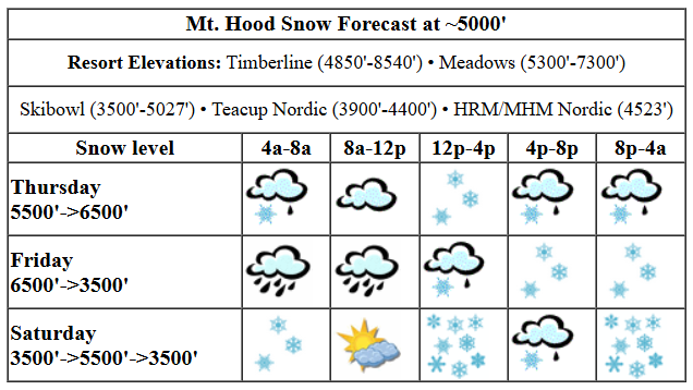
A cold front barrels in on Friday. Precip likely starts as rain and switches to snow. It’s going to be stormy and windy all day as westerlies rise to 40mph. Cross your fingers for lots of snow out of this (as of right now, we’re looking at 4-7”) because there’s not much in the forecast beyond that for a while. Have an awesome sunny week on the slopes!
Was that helpful? I knew it was! Guess what? All of this crucial work – from your personal wind and snow reports to the invaluable TATAS updates – is made possible by my relentless efforts. Maintaining this labor of love isn’t easy. Each daily forecast takes hours. Website hosting, weather model access, and back-end admin work takes time and money. That’s where you come in.
YOUR CONTRIBUTION MAKES A DIFFERENCE
- SUPPORT ACCURATE, HYPER-LOCAL WEATHER FORECASTING
- ENABLE ACCESS FOR ALL, EVEN THOSE WITH LESS MEANS
- SUPPORT A COOL HUMAN WHO WORKS HARD SO YOU CAN PLAY
Take a moment to click one of the buttons below. Donate $19.99 or more (how much does this forecast enhance your life?) and get the email in your inbox. Whether it’s a renewing subscription (auto-renew) or a one-time donation, every contribution makes a real difference. Help me keep this labor of love alive, so we can all continue playing, commuting, and living in the Gorge with peace of mind and the best weather forecasts possible. Thank you!


Hood River, Oregon 97031


GORGE WIND FORECAST
Hi friends! Plenty of east wind on the calendar this week, and there’s a chance of westerlies Friday and Saturday. Monday starts with pressures of 30.35/30.44 for an east 0.09 gradient. Easterlies start at 25mph at Iwash (Rooster) Rock and build to 35mph after noon. At Stevenson, the day starts with 20mph and slowly builds to 30-35mph. River flow over the last 24 hours was 109-184kcfs, river temp is 44.42F, and high temp forecast is 44F with sunshine in the windy zone.
Tuesday brings bigger gradients and more wind. The day starts with 50mph at Iwash and drops to 40-45mph. Stevenson starts with 25mph and slowly builds to 30-35mph, peaking after noon. High temp: 40F with sun in the morning and high clouds later. Wednesday won’t be strong enough for wind sports, sorry: easterlies start at 15-20mph, quickly fade to near-nothing, and return at 15mph only at Stevenson in the afternoon. Stronger easterlies are in the cards for Thursday. Offshore high pressure settles in as a cold front swings south from Alaska on Friday. With relatively strong wind aloft, this is a good setup for the Hatch and Rufus; both like this setup. At this point, it’s not a matter of if we’ll see westerlies, it’s a matter of whether they’ll be strong enough. There’s a decent chance the Hatch will give us a bonus session Saturday. Fingers crossed! Have fun on the river this week!
BARE BONES HOOD RIVER FORECAST
Nothing this morning, breaks midday, returning Nothing later. Temps start in the low 40s and rise to the mid 40s. Light easterlies. No rainbows. Tuesday will be Nothing. Temps start in the mid 30s and rise to the upper 30s. Easterlies. No rainbows. Wednesday will be Nothing and cloudy with a chance of a little drizzle (unlikely) in the morning. The weather then turns mostly clear. Temps start in the mid 30s and rise to the mid 40s. Light easterlies. 1.5% chance of rainbows.
TEMIRA’S AWESOME TRAVEL ADVISORY SERVICE (TATAS)

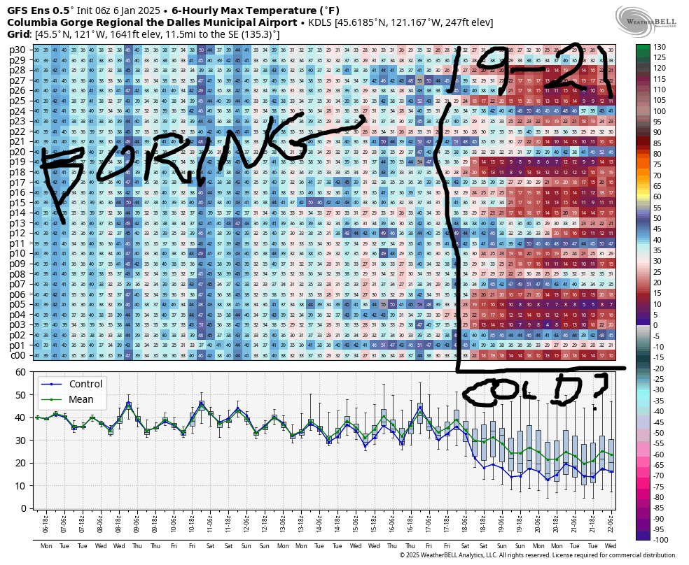
Good morning, neighbors! Finally… some weather that’s less time-consuming! Other than a wee chance of a little drizzle/ice for a few select folks Tuesday night, the week looks dry all the way through Thursday. We’ll even have some sunshine today and Wednesday. Yay! Looking way out into the future, models are hinting at some potential for our first real cold snap of the year (I still have a live outdoor tomato plant, which is batshit) around the 19th or 20th of this month. But you know how much we trust long-term models, right? About as far as we can throw the super computers powering them!
Monday kicks off partly Nothing, turns mostly clear, and sees the Nothing start to rebuild in the afternoon. Rather than throwing a hissy fit about the Nothing, head up or west to get away. Temps max out in the low 40s today. Wind will be light most places with E 30-35 this afternoon at Iwash (cock) Rock and Stevenson.
Clear sky above the Nothing overnight sends temps below freezing where the sky is clear. Wet roads ice up. Those of you in the Nothing have frosty roads. Below the Nothing on Tuesday, the day will be dark, gloomy, oppressive, and etcetera. Above it, you’ll find sun in the morning and high clouds later. Head to the mountains for 40 degrees. Stay down here for upper 30s along the river and freezing temps in the mid-level zones. Head to Stevenson for easterlies at 30-35mph and head to Iwash (schlong) Rock for 40-50mph wind.
Wednesday (my birthday, cards are welcome) could start with a wee bit of drizzle (ice in the middle elevations), but models are far from all-in on this. By afternoon, the sun busts up the clouds. Temps rise to the low-mid 40s. The wind turns light and variable with the exception of easterlies at 15mph near Stevenson.
Thursday: Nothing, strong easterlies in the usual spots, increasing high clouds aloft. On Friday, Alaska sends us our first (I think) NW system of the season. This will drop some snow on the mountain, and it’ll fire off moderately strong westerlies in the lowlands. Rain shadowing will be in full force with this one – precip should stay west of The Dalles and completely avoid south Wasco and Sherman counties, locations that take up a disproportionate number of characters when compared to their populations. I’ll need to find a shorter way to say “South Wasco and Sherman counties”. Suggestions are welcome. Plus, I’m never quite sure which words in that phrase need capitalization, so having a good (and dirty, of course) acronym would help.
Moving on… the weekend looks cool and dry with at least some sun. We’ll (probably) stick with dry weather next week. Models then, with a ton of range, are eyeing a cold snap around the 19th. That’s a couple of weeks out, so we’re going to see some regression to the mean. But seeing as how the GFS (see image), which is always overly aggressive with cold snaps, is calling for low double digits, there’s lots of room for regression while still retaining the label “cold”. Looking at the ECMWF, there are still ensemble members holding on to “normal” temps and completely refusing to engage in the frigid temp forecast. So, lots of time for things to change. And hopefully enough time for me to remember to top off the antifreeze in my truck. Safe travels. -TATAS


