MT. HOOD SNOW FORECAST

Hi skiers and snowboarders! Dumping snow continues through Tuesday morning. Yes! Models now give us a short window to make the most of it Tuesday before rain slams into Mt. Hood on Tuesday afternoon. Rain sticks around through Wednesday midday along with very strong wind. Don’t be surprised if the resorts throw in the towel on Wednesday. Beyond Wednesday: rather warm, intermittently damp weather for the rest of the week. A cooler period, maybe cool enough for snow, is possible for at least part of next weekend. The interquartile range (25th percentile through 75% percentile) for snow through Tuesday morning is 13-17”, in case you were wondering.
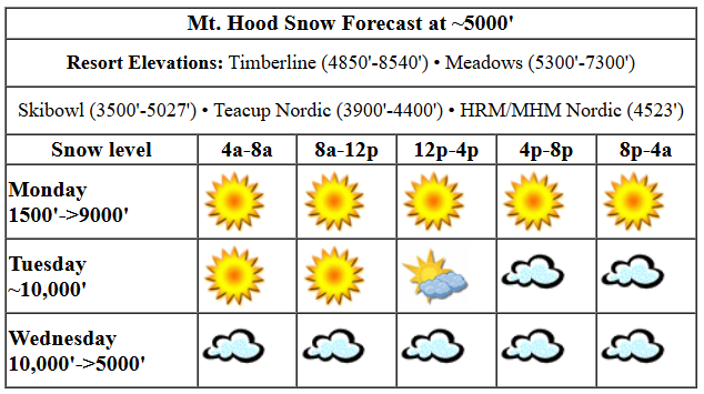
Monday just looks darn snowy. With temps hovering in the low 30s at 5000′, the snow will be heavy. Base-building snow, right? Timberline and Meadows picked up 7-9” overnight on top of about 18” in the last couple of days. Today, they’ll pick up more. The snow level will be around 4000′ today and will fall to about 3000-3500′ overnight thanks to very heavy precipitation rates (that’s a thing, you know!). During Tuesday daytime, prior to noon, about 0.6” water equivalent (WE) will fall for 4-6” heavy snow at 5000′. A brief break in the weather this afternoon – with sun breaks – gives way to very heavy snowfall overnight. About 1.2” WE is forecast for 9-12” dense new snow. Wind: SW 20-40 this morning fades to SSW 10-20 this afternoon and builds to W 25 after midnight.
As of the writing of this forecast, it looks like there will be a window on Tuesday morning to enjoy the fresh snow. Scattered flurries early give way to high clouds in the morning, mixed precip in the afternoon, and rain overnight. The snow level will be about 3500′ early, 6000′ by 4pm, and 9000′ after midnight. It’s worth noting that the timing of the warm air has been shifting later. Just a trace of snow is forecast in the morning. In the afternoon, perhaps 0.3” WE of mixed precip falls prior to the switch to rain right around closing time (4pm). Overnight, about half an inch of rain is forecast. Wind: W 25 early, W 15 midday, SW 20-35 in the afternoon, and WSW 50 after midnight.
Heavy rain is forecast on Wednesday with the snow level bouncing around between 6000′ (briefly) and 9000′. While models currently offer up an inch of rain, west wind in the 30-50mph range suggests we’ll see quite a bit more thanks to orographic enhancement. All that rain will fall in the morning; the afternoon looks dry. Will the resorts run lifts on Wednesday? I wouldn’t be surprised if the answer is “no”. Light rain Thursday morning gives way to dry weather in the afternoon. Models keep the weather warm with intermittent bouts of rain through Friday. Saturday’s system might be cold enough for snow… maybe. That’s a long ways out. Let’s leave it here for now, shall we? Have fun in the freshies today and tomorrow!
GORGE WIND FORECAST
Hi friends! Wet easterlies stick around today and tomorrow. On Wednesday, westerlies return, and models are trending higher with the wind strength. They’re also, in a fun twist, trending sunnier. For Monday, we’ll have easterlies, but not quite enough for much of the day. Iwash (Rooster) starts in the mid 20s, drops to 15mph or so, and climbs back to the mid 20s this afternoon. Stevenson starts with less than 10mph and slowly climbs to 20-25mph in the afternoon. River flow over the last 24 hours was 93-139kcfs, river temp is 45.86F, and high temp forecast is 42F with sunbreaks late morning to early afternoon and rain the rest of the day.
Tuesday brings a round of slowly increasing east wind. Iwash starts with 25 and slowly, ever so slowly builds to 30-35mph after 1pm. Stevenson starts with 15mph and rises to 25mph from mid-morning on through the afternoon. High temp: 42F with dry weather early and rain in the afternoon. Wednesday’s that west wind day. There’s still a lot of range in the model predictions. As of now, it looks like we have potential for upper teens near Swell and mid 20s near Rufus with less than 10mph between Mosier and Doug’s. We’ll refine that as we get closer. It’s worth saying the wind is frontally-driven (not ideal) and will be quickly suppressed by quickly building ridging in the afternoon. High temp: 51F with sunshine in the afternoon. Beyond that: easterlies of some sort day after day. Have a great day today!
BASIC HOOD RIVER FORECAST
Rain all morning. Intermittent drizzle/sprinkles this afternoon. Temps start in the mid 30s and rise to 40 or so. Light easterlies. 79% chance of rainbows.
Tuesday will be rainy early, dry midday, and rain again in the afternoon. Temps start in the mid 30s and rise to 40 or so. Light easterlies. No rainbows.
Wednesday will be rainy early and dry after 10am with mostly clear sky in the afternoon. Temps start in the upper 30s and rise to the low 50s. Moderate westerlies. 99% chance of rainbows.
TEMIRA’S AWESOME TRAVEL ADVISORY SERVICE

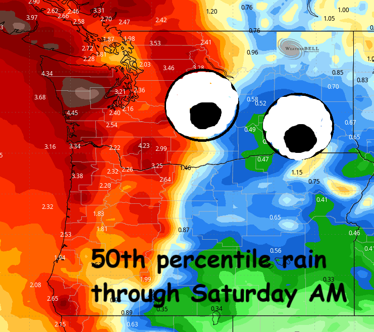
Good morning, neighbors! Looks like the “it’ll probably snow in a few places” forecast verified; Parkdale, Glenwood, and a few other locations are picking up sloppy snow this morning. Today’s probably not the end of the sloppy snow story. Down low – widespread rain, and not just today. Periods of heavy rain continue through Wednesday. Models have been all over the place on how much rain and when much rain, but rain we shall receive, and hopefully enough to erase the monthly/yearly rain deficit. Now’s the month! Carpe mensum – seize the month! It seems likely we’ll achieve that goal. The 50th percentile precip for the next week is impressive.
For today, rain tapers off into the evening (but still drizzles between Cascade Locks and Hood River all day). Don’t get all excited about dry weather, because it ain’t gonna last. Heavy rain returns this afternoon just in time to F up the commute – expect pouring rain for your drive home from the metro area. Rain progresses inland this evening. It accelerates into “downpour” zone as far east as Celilo Village with moderate rain to Amayah’s and in south Wasco and Sherman counties. Arlington Triangle: rain. Remember all the discussion about precipitation intensity and snow? Very intense precip tonight puts Parkdale, Snowden, and this morning’s other snowy areas at risk for wet, sloppy snowfall again tonight. Call it “sloppy seconds” because it’s round two. That’s what that phrase means, right? Today’s temps max out in the upper 30s in the lowlands. Wind: E 15-25mph at Iwash (wanker) Rock and Stevenson.
A brief period of mostly dry weather on Tuesday morning gives way to a system from the south late morning. This one drops heavy rain west of Hood River and moderate rain east to The Dalles and areas south of The Dalles. Between 1pm and 7pm, just in time to mess up your rural-urban commute, the heavens drop a downpour west of Mosier. High temp: upper 30s to low 40s. Wind: 25-35mph at Iwash (weenie) Rock and 15-25mph near Stevenson. Once again, very high precip rates in the morning put the usual cold spots at risk for sloppy snow.
Yet another round of heavy rain graces the Gorge Tuesday night into Wednesday morning. We should all be above freezing by then. Morning commute west of Hood River: unpleasant. Rain extent eastward: all the way past Boardman. South Wasco and Sherman: rain shadowed thanks to the westerly nature of this system. Up in the mountains, it’ll be pouring rain and super windy on Wednesday morning. Speaking of wind, it’s likely to turn westerly through the Gorge and scour out this cold, ucky air. Wind strength: 15-25mph out of the west. With the west wind comes clearing skies; expect sunshine on Sunday afternoon everywhere except locations aligned with the Cascade Crest. That’s what you get for aligning with Crest. You should have committed to Aquafresh instead. Thank the westerlies for a jump in temps. Lowland areas max out near 50 degrees.
Intermittent rain continues on and off for the rest of the week. Temps look unseasonably warm aloft. Down lower: no sign of significant winter weather. Safe travels. -TATAS


