

GORGE WIND FORECAST
today’s gorge wind forecast
Hi friends! A couple more days of westerlies are on tap in the Gorge wind forecast, and then we enter a period of well-deserved rest. In response to approaching cool air, we’ll have (eventually) moderately strong Corridor westerlies today and strong eastern Gorge westerlies tomorrow. An inland low pretty much shuts things down on Saturday. Cross-Cascades temps look equal (probably – there’s some uncertainty) Sunday through Tuesday, which will knock winds down to the light/variable range. Probably.
Before we dive into the forecast, let’s talk about a forecast legend who needs your help. Bingen Bart, now of Rowena, lost everything in the recent fires. Bart got me started as a forecaster, teaching me about these weather models and showing me how to interpret them. For that, I’ll be forever grateful. For years and years and years, Bart told each and every one of us where to spend the day on the water, and he gave us the inside scoop on conditions at Meadows. Now it’s time for us to step up and support him. I’m sure many of you have already donated to the GoFundMe for Bart, but here’s your chance to do so if you haven’t. Please do open up your hearts and wallets to support Bart, our friend and a pillar of the community.
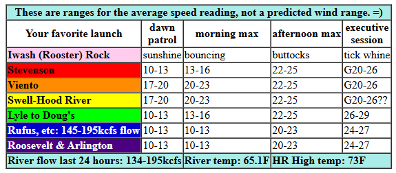
Okay. Forecast: Juneteenth started off with pressures of 30.09/30.02/30.00 for gradients of 0.07/0.02. Early wind was 20mph from Viento to Swell with 10mph or less everywhere else. If you’re seeking a mellow day on the water, get it early. Westerlies take advantage of an increasing thermal gradient this afternoon and build. By late morning, we’ll have 20-23 from Stevenson to Mosier Early afternoon: 22-25 from Stevenson to Doug’s with 18-22 at Avery. Evening wind rises to gusty 21-26 from Stevenson to Mosier with 27-30 from Lyle to Rufus. There’s some chance Swell-Hood River will drop below 20mph due to metro area clearing… Arlington builds to 23-36 in the evening, and we may see 17-20 at Threemile. East of there, the wind remains light. River flow over the last 24 hours was 134-195kcfs, river temp is 65.1F, and high temp forecast is 73F.
RIVER FLOW FOR SITES BETWEEN AVERY (EAST OF THE DALLES) AND RUFUS: CLICK HERE FOR JOHN DAY DAM FLOW.
RIVER FLOW FOR SITES BETWEEN STEVENSON AND DOUG’S BEACH (WEST OF THE DALLES): CLICK HERE FOR THE DALLES DAM FLOW

tomorrow’s gorge wind forecast
Friday sees cold air push into the Gorge thanks to a cold front and a trough. Much-needed rain falls west of Mosier. Models currently have areas west of The Dalles pretty light all day: 7-10mph in the morning and 15mph or so in the afternoon. East of The Dalles, from Avery to Boardman, we’re looking at 25-28mph in the morning and 29-33mph in the afternoon. High temp: 61F for Hood River with 67F at Arlington under partly cloudy sky.
extended Gorge wind forecast
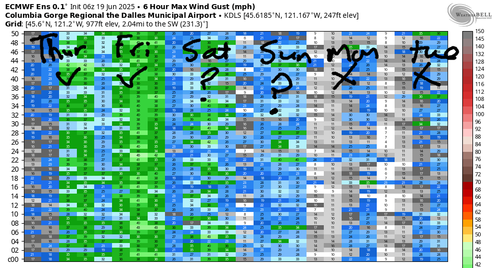
A stronger weather system is scheduled for Saturday. Areas west of The Dalles will be light all day: 10-13mph in the morning and less than 10mph in the afternoon. From Philippi Canyon to Boardman, the day starts with 20-23mph. Afternoon westerlies will be 12-15mph from Avery to Boardman. In other words, not much is happening on Saturday. There’s some range in the forecast for Sunday, Monday, and Tuesday, but as of now, the deterministic GFS says “light and variable”. Let’s just watch and see if any of those days turn stronger, but for now, the setup isn’t great. Westerlies are likely to return on Wednesday as the cross-Cascade thermal gradient and offshore high pressure return to lend a helping hand. Somewhere between Sunday and Tuesday you’re likely to find the rest day you’ve been looking for. Take full advantage of it. See you on the Nch’i Wana!
Was that helpful? I knew it was! Guess what? All of this crucial work – from your personal wind and snow reports to the invaluable TATAS updates – is made possible by my relentless efforts. Maintaining this labor of love isn’t easy. Each daily forecast takes hours. Website hosting, weather model access, and back-end admin work takes time and money. That’s where you come in.
YOUR CONTRIBUTION MAKES A DIFFERENCE
- SUPPORT ACCURATE, HYPER-LOCAL WEATHER FORECASTING
- ENABLE ACCESS FOR ALL, EVEN THOSE WITH LESS MEANS
- SUPPORT A COOL HUMAN WHO WORKS HARD SO YOU CAN PLAY
Take a moment to click one of the buttons below. Donate $19.99 or more (how much does this forecast enhance your life?) and get the email in your inbox. Whether it’s a renewing subscription (auto-renew) or a one-time donation, every contribution makes a real difference. Help me keep this labor of love alive, so we can all continue playing, commuting, and living in the Gorge with peace of mind and the best weather forecasts possible. Thank you!


Hood River, Oregon 97031


JONES BEACH, SAUVIE ISLAND, & COAST FORECAST
Wind northerly unless otherwise indicated. For coast, it’s North/Central/South with the “central” at approximately Florence. Swell forecast from NWS for central coast. Jones: westerly unless otherwise stated. Sauvie Island: northerly unless otherwise stated. Thursday: NNW15-20/N15-20/25-30, W swell 6′ at 12 seconds. Friday: W10/W10/SW10, W 5′ @ 10. Saturday: W20/W15-20/LTNW, W 7′ @ 9. Jones Thursday: 21-24. Friday: 11-14. Saturday: LTW. Sauvie Island Thursday: 16-19. Friday: LTV. Saturday: S 10-15.
BARE BONES HOOD RIVER WEATHER FORECAST
Clear sky this morning turns high overcast later. Temps start in the mid 50s and rise to the low 70s. Light westerlies early. Moderately strong later. No rainbows. Friday will be cloudy in the morning with mostly cloudy sky in the evening and a chance of intermittent showers in the afternoon. Temps start in the upper 40s and rise to the low 60s. Light to moderate westerlies. 87% chance of rainbows. Saturday will be cloudy with rain! Temps start in the upper 40s and rise to the upper 50s. Light to very light westerlies. No rainbows.
TEMIRA’S AWESOME TRAVEL ADVISORY SERVICE
HYPERLOCAL WEATHER FORECAST FOR THE COLUMBIA GORGE
THE DALLES, HOOD RIVER, WHITE SALMON, TROUT LAKE, STEVENSON, CASCADE LOCKS, PARKDALE, ODELL, HUSUM, BZ, MILL A, WILLARD, GOLDENDALE, RUFUS, ARLINGTON, boardman
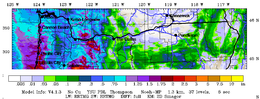
Good morning, neighbors! Remember when the Gorge use to have rainy days all the way into June? You know, when we had this thing called “Juneuary” and we wore hoodies and jackets in the sixth month? Well, Juneuary is forecast Friday through Sunday this weekend, and then it’s back to our regularly scheduled warm and sunny weather. So much for a hot and sunny summer solstice! Today’s graphic shows rainfall for the Gorge through Saturday evening from the 4/3k GFS. We’ll keep watching this one for a high-resolution picture of what might happen here; it’s worth noting that the current deterministic GFS seems to be at the high end of the rain possibilities from the ensembles. Maybe it’s right. Maybe it’ll back off. We’ll look again tomorrow.
today’s holiday
Before we dive into the forecast and Glenwood, let’s dive into Juneteenth. Today we celebrate the freeing of Black folks from enslavement. TATAS thinks it’s a damned fine thing that Juneteenth is a federal holiday – it’s been celebrated since at least 1866 by Black Americans. For me, as a White person, this is a day of both celebration and reflection: we’ve ended slavery mostly – the 13th amendment still allows us to enslave folks who are incarcerated – but we continue to engage in systemic, overt, covert, and other forms (microaggressions, segregation, etc) of racism that harm Black folks. It’s on us to do the internal work and to stand up against continued oppression of Black folks specifically and people of color in general. It’s also important for us to stand up against the 13th amendment exception that still allows some form of enslavement. This isn’t “woke”ness. It’s just plain old human decency and kindness. And you, reader, are a kind person. I see it in you.
glenwood and today’s gorge weather forecast
Juneteenth started out 40 degrees in Glenwood, where the tomato growing season lasts about 48 days, 7 hours, 5 minutes, and 53 seconds. At least it was sunny to start the day, and at least the sun has a lot of power this time of year.
Juneteenth weather will be sunny for all of us in the morning and increasingly high overcast in the afternoon. Temps rise to the low 70s (west), upper 70s (The Dalles), and low 80s (watermelon zones way out east). Morning westerlies will be spray-conducive at 10-15mph. Maude’s got spray going on right now. Be like Maude. Afternoon wind rises to 20-25mph from Stevenson to Murdoch with 25-30mph from The Dalles to Arlington.
friday’s gorge weather forecast
A weather system, a front accompanied by a trough to be specific, is on tap for Friday. This drags low, mid, and high clouds deep into the Gorge. We’ll see light to moderate rain west of Viento from 11am to 11pm with light rain possible to the west side of Hood River in the afternoon and evening. South Wasco picks up a few showers in the afternoon. Communities east of Hood River (with the exception of South Wasco) should be dry on Friday. Morning temps will be in the upper 40s, and afternoon temps rise to 60 (west), 67 (The Dalles), and 75 (watermelons). Wind will be 5-10mph west of The Dalles in the morning with 25-30mph east of The Dalles. Afternoon westerlies rise to 15-20mph west of The Dalles and 30mph east of The Dalles all the way past the Arlington Triangle and all the way to the bored men in Boardman.
saturday’s gorge weather forecast
Models now call for a wetter, potentially much wetter, system on Saturday. While there’s still quite a bit of range in how much rain will fall and how far east, the latest run has at least some steady drizzle all the way to Maryhill. Longer-lasting rain is forecast for The Dalles and areas to the west. That’s the GFS deterministic take on the situation. The ECMWF is less assertive with its rain forecast, but it still has 0.05-0.15” for The Dalles. Temps on Saturday will be in the upper 40s early. Afternoon: 59 (west, and potentially a record low-high), 65 (The Dalles), and 69 (watermelons). Wind will be light west of The Dalles and 20mph to the east. Cloud cover will be extensive for most of the day. This is, as you guessed, our highest risk day for damage to the cherry crops. Fingers and toes are crossed for our friends growing those cherries. Drivers: keep in mind that roads will be particularly slick with this recent rain as whatever makes roads slick decides to wake up and be slippery.
Enjoy the petrichor.
extended gorge weather forecast
Looking at Sunday, Monday, and Tuesday, we have dry, warming weather. By Tuesday, temps will be back to 90 degrees in The Dalles. In an interesting twist, models also give us a three-day (Sunday-Tuesday) break from the wind. Do with that as you like. Zero-wind days are great for tanning your buttocks at Iwash Rock. TATAS suggests you do this. TATAS will not being doing this, as TATAS prefers to keep their buttocks pale enough to blind folks. Safe travels. -TATAS
HEY! DON’T STOP READING! Is this community-focused forecast helpful to you? It sure is! It takes me a couple hours a day to write. Please join your friends and neighbors in contributing to keep it going. Venmo: @thegorgeismygym PayPal: twomirrors@gmail.com USPS: Temira / PO Box 841 / Hood River, Oregon 97031 You can test out the forecast subscription for a few days for free by signing up below. Easy! Do it!
