

GORGE WIND FORECAST
If you’re still seeing yesterday’s and it’s after 9am, try opening this in an incognito window
today’s gorge wind forecast
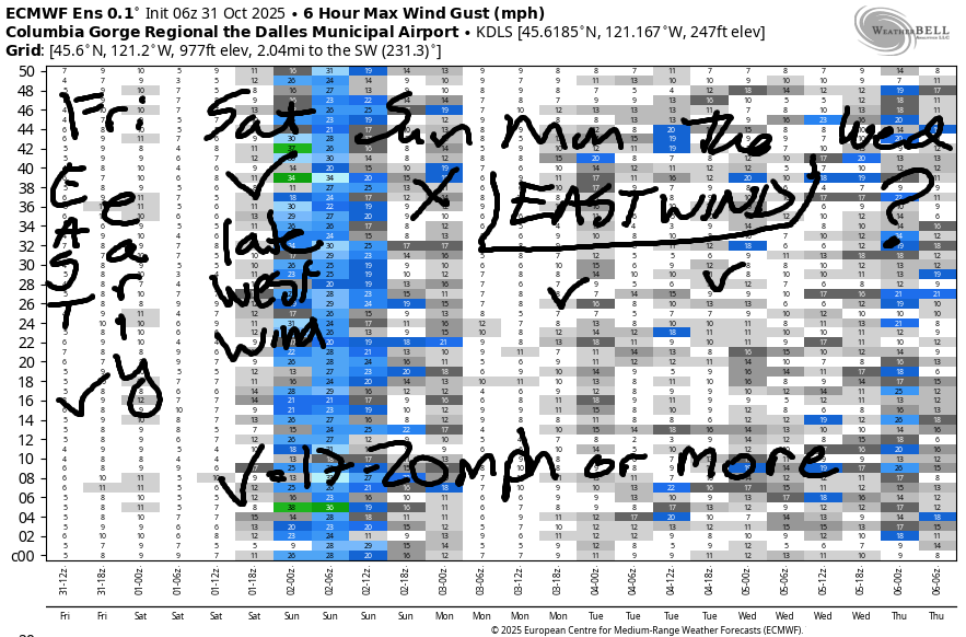
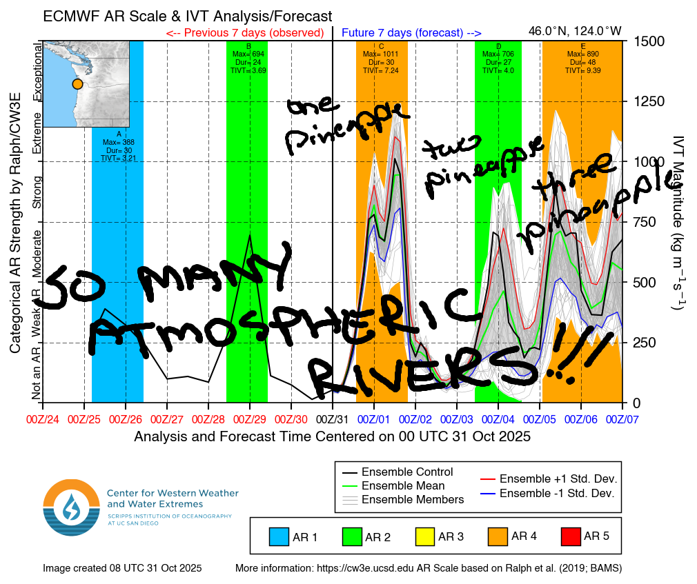
Hi friends! It’s Halloween, and another round of east wind is on tap. We do have a shot at westerlies late in the day on Saturday. Beyond that… not much on Sunday followed by east wind Monday and Tuesday. Models then drag us into a very active weather pattern with a series of atmospheric rivers and lows and all sorts of stuff. Details aren’t clear enough yet to pinpoint any possible wind, so I won’t try!
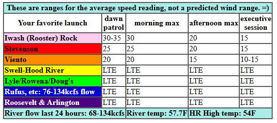
Friday started with pressures of 30.11/30.23/30.24 and solid easterlies: 37mph at Iwash Rock, 24mph at Stevenson, and 20mph at Viento. The wind holds until 11:34am or so and then starts to fade. By 2pm, we’ll be down to 20mph at Iwash/Stevenson with 15mph at Viento. By sunset, the wind will be down to 15mph as rain arrives. River flow over the last 24 hours was 68-134kfs, river temp is 57.7F, and high temp forecast is 54F.
RIVER FLOW FOR SITES BETWEEN AVERY (EAST OF THE DALLES) AND RUFUS: CLICK HERE FOR JOHN DAY DAM FLOW.
RIVER FLOW FOR SITES BETWEEN STEVENSON AND DOUG’S BEACH (WEST OF THE DALLES): CLICK HERE FOR THE DALLES DAM FLOW

tomorrow’s gorge wind forecast
Saturday starts with easterlies at 15mph at the usual spots. Late morning or early afternoon sees the wind go calm and then switch to westerly. Rain arrives from the west. With this setup, we generally see solid westerlies from Iwash to Stevenson to Viento with Swell 50/50 chance depending on how far east the rain extends. Models suggest the wind will switch after 2pm. Fingers crossed it happens before dark in the western Gorge! Models hint at gusty 20-25mph from Stevenson to Viento (maybe Swell) with light westerlies between Hood River and Doug’s and gusty 24-27 from Avery to Arlington. Those eastern Gorge sites aren’t going to pick up til late, and are even less likely to happen before dark. High temp: 61F for Hood River and 64F out in the desert with dry weather east of The Dalles.
extended Gorge wind forecast
Was that helpful? I knew it was! Guess what? All of this crucial work – from your personal wind and snow reports to the invaluable TATAS updates – is made possible by my relentless efforts. Maintaining this labor of love isn’t easy. Each daily forecast takes hours. Website hosting, weather model access, and back-end admin work takes time and money. That’s where you come in.
YOUR CONTRIBUTION MAKES A DIFFERENCE
- SUPPORT ACCURATE, HYPER-LOCAL WEATHER FORECASTING
- ENABLE ACCESS FOR ALL, EVEN THOSE WITH LESS MEANS
- SUPPORT A COOL HUMAN WHO WORKS HARD SO YOU CAN PLAY
Take a moment to click one of the buttons below. Donate $19.99 or more (how much does this forecast enhance your life?) and get the email in your inbox. Whether it’s a renewing subscription (auto-renew) or a one-time donation, every contribution makes a real difference. Help me keep this labor of love alive, so we can all continue playing, commuting, and living in the Gorge with peace of mind and the best weather forecasts possible. Thank you!


Hood River, Oregon 97031


MT HOOD SNOW FORECAST

Just a quick forecast since we have a lot of precip coming. Halloween on Mt. Hood will be cloudy with 15-20mph wind increasing overnight. Saturday will be (sad) rainy. The snow level starts at 12,000′. It falls to 10,000′ in the evening and down to 4000′ after midnight. Unfortunately, the bulk of the moisture will be wrung from the clouds prior to the drop in temps. How much rain? 1.8” or even more! How much snow at 5000′? Maybe an inch or so. Wind will be SW 25-35 in the morning, W 50 in the afternoon, W 35 around midnight, and WNW 25-30 after midnight.
A few flurries and clouds linger on Sunday morning before the sky clears in the afternoon. The snow level will be around 3500-4000′ during the day and will rise to 7000′ overnight. Wind: WNW 25-35 in the morning, light easterly in the afternoon, and E 25 overnight.
Beyond Sunday: next week brings a series of systems with the snow level fluctuating wildly. We’re set for several rounds of atmospheric river (Pineapple Express) with potentially heavy rainfall at times. We’ll dive into the details as we get closer to next week and the details become more clear.
BARE BONES HOOD RIVER WEATHER FORECAST
Clouds today with rain tonight. Temps start in the mid 30s and rise to the mid 50s. Light easterlies. No rainbows. Saturday will be cloudy with rain/showers into early evening. Temps start in the low 40s and rise to the low 60s. Light easterlies early. Moderate to moderately strong westerlies later. 99% chance of rainbows. Sunday starts with a little drizzle and ends dry. Temps start in the low 40s and rise to the upper 50s. Light westerlies early. Calm later. 28% chance of rainbows.
TEMIRA’S AWESOME TRAVEL ADVISORY SERVICE
HYPERLOCAL WEATHER FORECAST FOR THE COLUMBIA GORGE
THE DALLES, HOOD RIVER, WHITE SALMON, TROUT LAKE, STEVENSON, CASCADE LOCKS, PARKDALE, ODELL, HUSUM, BZ, MILL A, WILLARD, GOLDENDALE, RUFUS, ARLINGTON, boardman
Good morning, neighbors, and happy Halloween! May you be safe from the forces of greed, hatred, and delusion this evening – those are the scariest things around. May you also stay dry. This, at least, is likely. Rain is scheduled to arrive around 8pm in Cascade Locks and even later to the east.
One bummer this year: the price of Halloween candy is way up. Yup.
Glenwood this morning
On to Glenwood this morning, where hopefully ranchers are doing okay. And by okay, I mean financially, not temperature wise. We all know that it’s cold in Glenwood this time of year. This morning it’s 27 degrees there, cold enough to freeze the balls off even the manliest of Glenwood men. Because the manlier you are, the warmer your nuts are, but that also means that your sperm are less virile and… maybe I have it wrong. Maybe the manlier you are, the colder your balls are?
Today’s Gorge weather forecast
The rest of us start with cold (but hopefully not blue) balls today under high clouds. Temps rise to the mid 50s this afternoon pretty much all across the lowlands. The usual spots see east wind: Iwash with 35mph this morning, Stevenson with 25mph, and Viento with 20mph. Afternoon sees the wind fall below 20mph in those spots. Elsewhere, the wind stays light today. Rain arrives this evening around 8pm in Cascade Locks and extends as far east as Rowena (lowlands) and Centerville (hills) tonight. South Wasco: dry. Driving through the Gorge tonight? Expect very heavy rain and unpleasant conditions to the west of Hood River all night long. Snow level: 12,000′.
Saturday’s Gorge weather forecast
Heavy rain continues west of Hood River with light/moderate rain to Rowena into Saturday afternoon. This system finally slides east in the afternoon and drops a little rain on South Wasco and areas east of Rowena. As the system moves through, 1) the wind turns westerly; 2) rainbows proliferate; and 3) temps rise. Morning temps will be in the low 40s. Afternoon: low to mid 60s thanks to the tropical nature of this system. Wind will be E 15mph in the usual spots in the morning. Afternoon wind rises to 20-25mph west of Hood River, stays below 15mph (or even calm!) between Hood River and Murdoch, and rises to 25mph from Avery to the Arlington Triangle. Up in the exposed hills and passes: very windy. Snow level falling from 10,000′ to 4000′ overnight with little accumulation other than deciduous leaves and larch needles.
Extended Gorge weather forecast
Sunday starts with a little lingering drizzle then turns dry. Expect partly cloudy sky all day with rainbows in the morning and sunbeams in the afternoon. Morning temps: low 40s. Afternoon: 60ish. Wind: light westerly becoming calm. Monday looks mostly dry with a short period of drizzle possible midday. Overnight into Tuesday, rain (probably) arrives from the south. Rest of next week: rather wet as a series of atmospheric rivers cozies up to the Pacific Northwest and rains, rains, rains all over the place.
Snow level next week: mostly too high for accumulation at the ski resorts, all of which are struggling to get liability insurance thanks to a quirk of Oregon law. They’re kinda in the same boat as we are – struggling to get reasonably priced property insurance and/or reasonably priced health insurance, not to mention food. Maybe you shouldn’t be allowed to serve in Congress if you make more than 4x the poverty wage or have enough money in the bank to retire…If that were the case, our reps would have a better chance of understanding the lives of real people. Safe travels. -TATAS
HEY! DON’T STOP READING! Is this community-focused forecast helpful to you? It sure is! It takes me a couple hours a day to write. Please join your friends and neighbors in contributing to keep it going. Venmo: @thegorgeismygym PayPal: twomirrors@gmail.com USPS: Temira / PO Box 841 / Hood River, Oregon 97031 You can test out the forecast subscription for a few days for free by signing up below. Easy! Do it!
JONES BEACH, SAUVIE ISLAND, & COAST FORECAST
ON WINTER VACATION UNLESS DESPERATELY NEEDED.
