Downwinding In The Gorge
Photo by Alon B. Rider: Andy K.
WELCOME TO THE GORGE, DOWNWIND FROTHERS
If you’re reading this, YOU are a frother.
To froth: to get really, really excited about something. To be stoked.
We, the local downwind crew, welcome you to our home playground. We hope you’ll become part of our crew – share shuttles with us, be friendly, and encourage each other. Here in the Gorge, we celebrate each person’s successes. We cheer for the progress each person is making. We don’t objectify (judge attractiveness, talk about sexually) our female riders. We welcome folks of all gender identities, sizes, nationalities, religions, sexual orientations, and skin colors. Join us in keeping the vibe positive and supportive for all.
In addition to keeping the vibe friendly, we need your help in ensuring we retain access to our launch and takeout sites, especially near the Hatchery. In the summer of 2024, people disrespecting Spring Creek National Fish Hatchery staff resulted in parking being severly limited. Please read below and help us out!
The lower hatchery, aka The Basement, is on federal property and is not an Oregon State Park. Access is not guaranteed. There are around 25 people working out of the Spring Creek Fish Hatchery complex, including the normal facility staff to many former work-at-home federal employees who now must report to an office. These folks are working the 9-5 grind and many are facing additional stresses due to the actions of the current administration. Many employees were recently fired, and the remainder are working harder than ever.
When we park in the road, even for loading and unloading, we cause access problems for these folks. Parking along or in the road also results in restricted access for emergency vehicles. Doing so is not okay, and will put our access at risk. We have had several conversations with the hatchery manager and he is fairly strict with his requests.
Due to lack of compliance with requests by Hatchery employees, the majority of the parking at the Basement was lost last year when the roadside parking was blocked by the Hatchery staff with boulders. There are currently about 15 spots. If you are not actively involved in downwind shuttling, please park elsewhere, perhaps at the very end of the road in the “overflow” area near the actual hatchery. If you are not downwinding, please consider launching and landing from the Hatchery state park.
Help us out! If you’re loading boards, pull way off the road, turn on your blinkers, and move quickly. Time for conversation is when you’re in the van, not when you’re loading the van. If you see folks not following these guidelines, say something. To ensure access, we need to hold each other accountable. If you are approached by a hatchery employee, be respectful. Be kind. Immediately comply with their requests, and pass their requests along to others who are recreating that day.
Parking at Tunnel 4 and Tunnel 5 is also at risk. Per State Patrol, any accidents at these locations may result in “no parking” signs being installed. Tunnel 4 parking is on BNSF land. Do not block access to the railroad. Do not park overnight. When you leave Tunnel 4, drive WEST (right) about 1.5 miles to a safe turnaround. Do not turn east (left) – the sight line is minimal and there have been close calls. At Tunnel 5, go as far west as you can. Open your window. LIsten for cars coming in the tunnel. It is still safer to go right to the turnaround past Tunnel 4. Saving a couple minutes isn’t worth putting your life, others’ lives, and access at risk. Do the safe thing!
THE CORRIDOR – STEVENSON TO HOOD RIVER
STEVENSON (OR CASCADE LOCKS) TO…
- WIND DIRECTION: west wind
- SPORTS THAT DO THIS RUN: Generally speaking, this one is for Outrigger Canoes and Surfskis.
- LAUNCH/TAKEOUT: Launch at the boat ramp at the east end of Stevenson. Or launch at the boat ramp in Cascade Locks. Takeouts: Drano Lake is a boat ramp; Home Valley is a sandy/gravel walk up; Hood River Waterfront Park and Event Site are gravel / grass; Bingen is a boat ramp; Moiser is a gravel beach.
- SWELL SIZE: Small to start, potentially large to XL as you come through the Hatchery. Continuing M/L to Bingen and Moiser. Smaller on the OR side for the takeout in Hood River.
- LENGTH OF RUN: Varies – 5 miles to Home Valley, 13 miles to Hood River, 20ish miles to Mosier. You could keep going all the way to The Dalles (Klindt’s Cove or the Waterfront Park) if you wanted to!
- MAX CURRENT: not certain, but under 200kcfs is better than above
- COST / PARKING PASS: Free in Stevenson, Home Valley, Drano Lake, and Bingen. Hood River varies – street parking is free if you can find a spot; otherwise $2.75/hr or yearly parking pass for the Event Site / Waterfront Park. Moiser is paid parking as well.
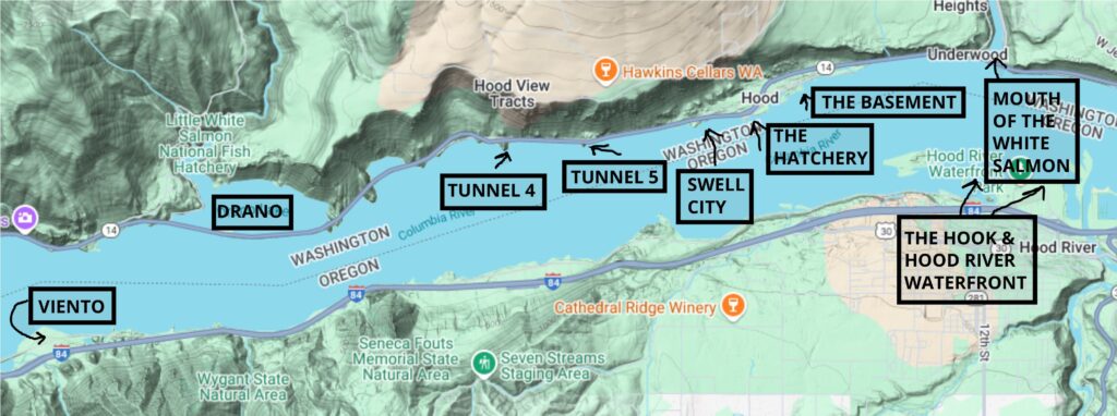
VIENTO TO HOOD RIVER
- WIND DIRECTION: west wind
- SPORTS THAT DO THIS RUN: Outrigger, Surfski, 14′ / 12’6″ SUP, wingers, and occasional SUP foilers
- LAUNCH/TAKEOUT: Slippery river rock at Viento for the launch. Takeout at the Hook is sand/gravel; takeout at Hood River Waterfront Park is (sometimes) slippery gravel to a grassy hangout.
- SWELL SIZE: Small to start, potentially large to XL as you come through the Hatchery, and small with lots of pumping to finish.
- LENGTH OF RUN: 7.5 miles to the Hook, 7.9 miles to the Event Site
- MAX CURRENT: not certain, but under 200kcfs is better than above
- IMPORTANT INFORMATION: Potential bail points at Tunnel 4, Tunnel 5, Swell City and the Hatchery, but you’ll be on the opposite side of the river from your cards. There’s also a private beach emergency takeout on the OR side across from the tunnels.
- COST / PARKING PASS: $10 daily, $30 for one year, $45 for two years via Oregon State Parks. Various passes / hourly fees required to park at the Hood River Waterfront for the takeout. 2-hour on street free parking at the Waterfront.
This run is more the purview of outrigger canoes, surfskis, and 14′ SUP boards, but if your cardio is tip-top, Viento could be for you. It has some advantages: no need to cross the Hood River Bridge (if you’re on the OR side); length; exercise…
The run starts at Viento State Park (camping available!) and finishes at the Hood River Waterfront Park. Theoretically, you could finish at the Hook, but the water can get quite shallow downstream of Wells Island (across from the Hatchery), and this probably isn’t safe. Most folks launching at Viento ride the swells through the Hatchery and beyond and then bear right (with lots of pumping) to the Hood River Waterfront Park.
Swell size is small for at the beginning of the run and steadily increases as you go downwind. Stay on the WA side of the river for the biggest, most consistent swell. Wind can be variable in this run. Read the forecast carefully and check the iWind/iKite sensors before attempting it. You don’t want a multi-mile schlong!
DRANO
- WIND DIRECTION: westerly
- SPORTS THAT DO THIS RUN: Outrigger, SUP foil, surfski
- LAUNCH/TAKEOUT: Park anywhere near the Drano Lake boat ramp. Put in there, and paddle west until you come to the bridge. Paddle under the bridge and out into the Columbia. Classic takeout is at the basement of the Hatchery, but you can also continue the run to the White Salmon Bridge.
- LENGTH OF RUN: 5 miles to the Hatchery, ~ 8 miles to the White Salmon Bridge
- MAX CURRENT: uncertain, but under 200kcfs is better than above
- SWELL SIZE: small to start, large to very large potential through the Hatchery. Stay on the WA side for the biggest swell.
- IMPORTANT INFORMATION: DO NOT try this during salmon fishing season. There are way too many boats in Drano Lake and at the mouth of the Little White Salmon River.
- COST/PARKING PASS: Free to park at Drano and the White Salmon Bridge. For the Hatch: as of 2025, you need a Discover Pass. $11.50 daily, $30 annual prior to October 2025, then $45 through Washington State Parks
Putting in at Drano lake gives you a couple miles more shredding than the Tunnel runs. The first half is likely to have small bumps. Paddling? It’s probably going to be a lot of work. Bump size increases, potentially exponentially, for the second half of the run. Be prepared for varying conditions, and bring your cardio for the potential pumpfest.
To do this run, you’ll park near the Drano Lake boat ramp. Paddle to the west end of Drano Lake, under the bridge, and out into the Columbia. Stay out of the way of fishing boats, and please do not do this during fishing season. We don’t want to cause conflict with our fishing friends.
Traditional takeouts for this run are the Basement (bottom of the Hatchery) or the White Salmon Bridge (lots of pumping, a sketchy takeout, and limited parking).
TUNNEL 4 & TUNNEL 5
- WIND DIRECTION: westerly
- SPORTS THAT DO THIS RUN: SUP foil
- SKILL LEVELS YOU MIGHT SEE HERE: intermediate to pro
- CURRENT: strong in spring, less in summer
- LAUNCH: You’ll be walking across SR-14 for both launches and walking down a rocky path. Having a spotter when you cross the road is advised.
- LENTH OF RUN: Tunnel 4 is 2.6-3.0 miles. Tunnel 5 is 2.0-2.3 miles. Depends how many turns you make!
- IMPORTANT INFORMATION: To access the parking, you’ll be pulling off the highway right after you go through a tunnel. Please use your hazards and/or signal early. When leaving Tunnel 5 (the closest one to the Hatchery), pull directly into the eastbound lane from as far west as possible. Open your window – you can hear cars entering the tunnel far before you can see them. When leaving Tunnel 4, do not pull into the eastbound lane. Head west about a mile where there is a safe turnaround. Both launches rely on WSDOT allowing us to park. Any interference / accidents may result in access being removed. Please take the extra time to avoid disrupting traffic. Do not block BNSF access to tracks/equipment at Tunnel 5.
- COST / PARKING PASS: Free at the Tunnels. For the Hatch: as of 2025, you need a Discover Pass. $11.50 daily, $30 annual prior to October 2025, then $45 through Washington State Parks
Tunnel 4 and Tunnel 5 are the two most popular runs in the Hood River area. Please see the information at the top of this page for parking and access concerns. We, the locals, need your help to retain access.
Both access points are on WSDOT land, and both points require both a walk across the freeway (limited sightlines) and a walk down a steep dirt/rock path. Be very careful crossing the roads, and use a spotter for the limited sight lines when crossing the road. Any accidents put us at risk for access being revoked, and more importantly, we don’t want anyone hurt. Be careful! Crossing freeways on foot is never a good idea!
Now, on to the run description: on many days, bump (swell) size and wind between T4 and T5 are quite different. T5 is more of a sure thing, but T4 gets you an additional 3/4 mile. At the T4 start, the bumps can be a bit disorganized, but they usually clean up halfway to T5. T5: usually a clean, easy takeoff not far from the beach.
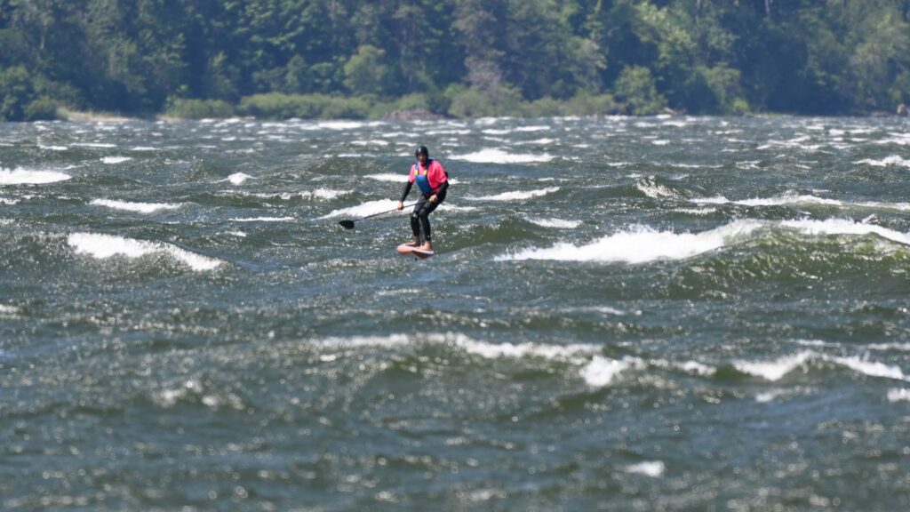
Swell size grows as you approach Swell City, and then chaos hits: from Swell to the point of the Hatchery, conditions can get 1) super disorganized or 2) ginormous if the wind is strong enough. We locals call this “paddle purgatory”; fall off here, and it can be tricky to get back up. Bring your turning game to stay on the bumps. Once you hit the Hatchery, the swell usually cleans up and gets steeper, but then you have traffic to contend with: windsurfers, wingers, e-foilers, kiters, outriggers, surfskis… you name it. Everyone goes through the Hatch. Make eye contact. Holler. Have a whistle, or be super-rad and carry a small airhorn. Below the cove at the Hatch, you’ll find less people and also less-steep bumps.
On a light day, you can take out at the cove, or you can continue another 1/2 mile to the Basement, where the locals will be hanging around waiting to cheer your arrival at the parking lot.
SWELL CITY
- WIND DIRECTION: westerly
- SPORTS THAT DO THIS RUN: SUP foil, wing, parawing, windsurf
- SKILL LEVELS YOU MIGHT SEE HERE: intermediate on up
- CURRENT: strong in spring, less in summer
- LAUNCH: Easy walk down to sheltered pea gravel cove.
- LENTH OF RUN: About 1-1.5 miles to the Hatch basement.
- IMPORTANT INFORMATION: The river can be quite disorganized in this section – make sure your balance skills are on point as are your quick turns if you come ripping through here. This zone is sometimes referred to as “paddle purgatory”. Watch for windsurfers who are not watching for you coming from upwind.
- COST / PARKING PASS: You will need a membership in CGW2 and a season launch pass ($80) for Swell City. Launch passes are per person or family, not per car.
Sometimes there’s not enough wind at Tunnel 4 or Tunnel 5 for your skill level (or mine). If that’s the case, Swell City, about 1/2 mile west of the Hatchery, is a launch option. You will need a pass to launch here. The pass is not for parking – the parking is on WSDOT land. It’s a launch pass, and you’ll need one for each person launching. Policing by Swell City passholders is consistent, so do purchase a pass. You’ll be supporting the organization that works to keep river access open. It’s a good cause! Don’t poach!
HATCH LAPS & THE BASEMENT
- WIND DIRECTION: westerly
- SPORTS THAT DO THIS RUN: SUP foil and parawing
- SKILL LEVELS YOU MIGHT SEE HERE: beginner on up
- CURRENT: strong in spring, less in summer
- LAUNCH & TAKEOUT: rocky launch at the point of the Hatchery. Slippery rocks. Takeout is up slippery rocks in the basement.
- LENTH OF RUN: About 0.75-1.0 miles
- IMPORTANT INFORMATION: Launching at the point of the Hatch puts you right in the middle of all the other watersport traffic. Wear a bright rashguard and be alert.
- COST / PARKING PASS: as of 2025, you need a Discover Pass. $11.50 daily, $30 annual prior to October 2025, then $45 through Washington State Parks
Many folks begin their downwind journey by hopping in at the Hatch Point or the Cove at the Hatch. Bumps at the Point are steeper and easier to catch, but you’ll be contending with the whole rainbow of floating objects: windsurfers, kites, wingers, paddlecraft, barges, photographers, SUP foilers, parawingers… Make sure you wear a bright jersey so you can be seen, and be alert for folks not seeing you coming from upwind.
Bumps at the point are generally steep and often large. They flatten out as you head downwind, but they can also clean up. Looooooooong, glassy rollers are possible here. If you put in at the Cove, you can expect less river traffic, but also less steep bumps. Below the Cove is a great place to work on your balance if it’s your first few times out in the river.
This doesn’t mean the Hatch is a beginner spot. On the contrary, the combo of crowds, strong current, and big swell demand some familiarity with high-wind conditions in the Columbia River. If you’re brand new, spend some time at other locations (Nichols Boat Basin, the Hook, Rowena, for example) getting use to the power of the river.
The Hatch point and Cove are short laps, and you can self-shuttle by walking back upwind. This takes maybe 10-15 minutes, or you might be able to get a ride with someone else back to the point. You can also prone paddle back upwind – this too takes 10-15 minutes. Again, make sure you have a bright jersey and helmet so you’re obvious to folks zipping back and forth across the river while windsurfing, winging, or doing other N-S-N-S sports.
LYLE TO RUGS / ROWENA TO THE DALLES
- WIND DIRECTION: westerly
- SPORTS THAT DO THIS RUN: desperate SUP foilers
- LAUNCH/TAKEOUT: slippery rocks at Rowena / sketchy cliff toss in Lyle
- SWELL SIZE: small to large depending on wind and location
- LENGTH OF RUN: 4-5 miles
- IMPORTANT INFORMATION: only try it if you’re desperate
- COST/PARKING PASS: Oregon State Parks pass at Rowena. Discover Pass for Doug’s Beach. No pass for Rugs or the takeouts in The Dalles.
If you’re desperate, you could try this. The put-in at Lyle involves a sketchy tossing of gear off a small rock cliff. The takeout at Rugs (about 1/2 miles downwind of Doug’s Beach) is fine. Expect flat water at the beginning transitioning to medium-large disorganized swell at the end. The Rowena run starts small, gets medium-large and disorganzied, and ends with a horrific flatwater, swirling-wind paddle/pump fest to various spots in The Dalles. You are not this desperate. If you’re learning, you could try practicing at Rowena or Doug’s. Doug’s, the one time I tried this, resulted in me getting blown all the way to the WA side of the river. I never did it again. I have not tried Rowena, but it does seem like it would be a good place to practice standing up in small bumps. You’d need to prone paddle back upwind. Takeout at Rowena: rocky and very slippery. Doug’s: sandy.
EASTERN GORGE
SILOS TO RUFUS BOAT RAMP (BIGGS TO RUFUS)
- WIND DIRECTION: westerly
- SPORTS THAT DO THIS RUN: Seems like any sport could do this one!
- SKILL LEVELS YOU MIGHT SEE HERE: advanced to expert
- CURRENT: never less than moderate. Anything over 200kcfs is a lot for paddling. Anything over 250kcfs is really, really difficult. Over 325kcfs, the current washes away the swell. Check the current here.
- LAUNCH: Easy walk in at the silos grain silos west of Maryhill Bridge. This is private property, and access depends on our good behavior. Do not park on the south side of the road under the trees. Park in the gravel as tight as you can on the north side of the road (river-side). If there is no more space, launch from Maryhill instead: there is a boat launch at the west end of the park and also one at the east end of the park. Both are easy access.
- SWELL SIZE: Large to massive and ginormous.
- LENGTH OF RUN: 7 miles from the silo to the Rufus boat ramp. ~4 miles to The Wall boat ramp. ~5 miles to the Rufus rock piles.
- IMPORTANT INFORMATION: Possible bail-out points are Maryhill, Peach Beach, The Wall, and the rock piles at Rufus. Relatively easy access to the freeway for the whole run.
- COST/PARKING PASS: Free at the Silos, Wall, and Rufus. Discover Pass required at Maryhill State Park.
Silos. When this is on, it’s spectacular. Big, clean, glassy swell stretches far across the river. For seven miles. Seven. Miles. Add in an easy shuttle on a 70mph highway, and there’s not much more you could want. How about Indian food? There’s a great food cart in Biggs on your way home.
The run starts with you setting shuttle at the Rufus boat ramp. Once that’s done, drive back to Biggs. Head through the stoplight towards the grain silos. Park on the right side of the road as tight as you can. DO NOT park on the left side of the road heading to the silos – this whole area is private property, and we’ve been asked not to park on the left. Walk to the water – the launch point is obvious. Expect slippery river rock and weeds. Paddle out about 50-100 yards, and you’ll be in short, steep swell.
The trickiest part of this run is the beginning when you’re shooting the gap on the Maryhill Bridge. Watch out. The water is chaotic, and those pilings are hard. Don’t hit them! Once you’re past the bridge, the water cleans up quickly. You’re in for a treat – when The Wall sensor is reading over 30mph, this run has big, glassy swell the whole way. Biggest, steepest waves are found between The Wall and The Wall boat ramp. Below that, the swell is still big, but it’s more rolling. And long, sometimes halfway across the river or more.
Watch for crowds of windsurfers at The Wall. Watch out for crowds of every water sport you can imagine when you go through Rufus. Once you’re past the Rock Piles, river traffic lessens. In that zone, there’s about 1/2 mile of somewhat disorganized water. But don’t despair – Rufus’ version of “disorganized” is pure bliss compared to most places.
Finish the run at the boat ramp. It’s past another grain silo and behind a short breakwater. You’ll see the parking lot – it’s about 10 feet above the river – before you see the dock and boat ramp. Most days you can catch a swell almost all the way in. This run is awesome.
Other options for this run include Maryhill-Rock Piles; Maryhill-Rufus Boat Ramp. The advantage of these two runs are that they are 1) shorter and 2) don’t require you to go under the Maryhill Bridge.
RUFUS ROCK PILES TO RUFUS BOAT RAMP
- WIND DIRECTION: westerly
- SPORTS THAT DO THIS RUN: SUP foil, parawing, or anyone else wanting a short (2 mile) run.
- SKILL LEVELS YOU MIGHT SEE HERE: beginner on up (but not beginner friendly in spring when the current is high)
- CURRENT: very strong in spring. less in summer.
- LAUNCH: Easy, but slippery, launch on river rock. Weeds. Drive to the far western end of the rock pile area at Rufus and launch upwind of the majority of the wing/windsurf/kite traffic.
- SWELL SIZE: Medium to large. Swell is small and steep at the beginning of the run and makes for easy paddle pop-ups. Bigger, less steep swell for the rest of the run can be hard to pop up on. Waves are clean and long, and the swell is generally organized. Easy place to balance!
- LENGTH OF RUN: 2 miles
- IMPORTANT INFORMATION: There’s lots of wing/kite/windsurf traffic. Wear a bright jersey and make eye contact with other water traffic. Watch for fishing nets during fishing season.
- COST/PARKING PASS: free
This run, despite being only a couple miles, is awesome. To access it, get off I-84 and head towards the Columbia. When the road Ts, head right to the takeout (Rufus boat ramp) or left to the put-in (Rufus rock piles). While there are often people to shuttle with, bike shuttling (mountain or e-bike) is a possibility. YStart upwind of the (dozens, hundreds of) wingers and kiters, and you’ll find short, steep, clean ramps that make it easy to get on foil. As you go towards the WA side of the river, the swell gets bigger and bigger. It also gets less steep, and for paddlers, it can be harder to get back up if you come off foil.
There’s a somewhat disorganized section about 2/3 through the run, but compared to anywhere else, it’s still clean and blissful. Thanks to the friendly water conditions, this is a good place to practice and learn. Just watch out for the crowds on the river – make sure you’re wearing a bright jersey and helmet so you can be seen.
One thing to be careful of here is the current. Anything over 200kcfs is very hard for paddling up, and the swell starts to get disorganized over 275kcfs. Over 325kcfs is no-go for all sports. Take the current seriously – make sure you have the fitness to manage a potentially long swim in strong current if something goes wrong, and expect runs to take longer than expected due to the current.
THE WALL TO …
- WIND DIRECTION: westerly
- SPORTS THAT DO THIS RUN: SUP foil, parawing
- SKILL LEVEL: Advanced to expert
- LAUNCH/TAKEOUT: various options, but generally gravel of some sort
- SWELL SIZE: large to massive AND steep!
- LENGTH OF RUN: varies
- IMPORTANT INFORMATION: watch out for fishing nets during commercial salmon season. If you bike shuttle to Maryhill, watch out for the two dogs near the group of five trailers – those dogs have bitten at least one person in our crew.
- COST/PARKING PASS: free
The Wall is generally the domain of windsurfers thanks to massive, steep, breaking swell. It can be tricky to find – take the road that parallels the entrance to Maryhill park until there’s a Y. Right goes to a home. Left goes down a gravel road (cherry trees on the left) to The Wall. If it’s windy, you’ll see the windsurfers parked at the upwind launches; there’s a cove upwind and a second, trickier launch near the island downwind (you’ll see the “41” marker on the island). The boat ramp is about 1.5 miles down the road from the main windsurfer launches.
The main launches at The Wall are not beginner friendly due to lots of cross chop from windsurfers combined with huge, steep swell. If you’re learning, there’s a good spot about 100 yards upwind of the boat ramp – you’ll need to launch at the ramp and paddle upwind to it. With those warnings…
This can be a super-fun run if you don’t have the time or energy for a full silos run, and it can also be a quicker option early in the season when the current is strong. Launch at the upwind coves at The Wall. The water is a bit disorganized here, but the bumps are steep. Go 100 yards downwind, and you’ll be in MASSIVE swell (assuming it’s windy enough for massivness). These waves do not mess around – they get steep, and they break like crumbly ocean waves. Be alert and wear a bright jersey – this area gets very crowded with very skilled windsurfers doing huge aerial tricks. This run is short, but it’s awesome the entire way. You take out at the boat ramp past the actual “wall” – a 30′ tall cliff along the WA side of the river. Watch for fishing nets at the takeout during commercial salmon season.
BLALOCK TO …
- WIND DIRECTION: westerly
- SPORTS THAT DO THIS RUN: Pretty much any of the sports
- SKILL LEVELS YOU MIGHT SEE HERE: intermediate to pro. Absolutely NOT beginner friendly.
- CURRENT: moderate to strong in spring, less in summer
- SWELL SIZE: small and steep at the beginning, clean rollers for a while, small for a bit, then MASSIVE at Arlington. Paddlers: bring a good pop-up game for the middle – the swells are not steep, and it can be tricky to get back up if you come off foil.
- LAUNCH: easy gravel launch to culvert paddle. Approximately 100 yard paddle from the culvert out to the swell line. Watch for fishing nets in when commercial salmon season is on.
- LENTH OF RUN: Approximately 9 miles to Arlington, 23 to Threemile Canyon, and even further (47?) to Boardman
- IMPORTANT INFORMATION: There is a mile-long section in the middle of the run that tends to be quite flat and can also have less wind. Be prepared. The entire run is remote. If you break down in the middle, you will have a long walk on the railroad tracks to get back to your car. Consider carrying self-rescue equipment.
- COST / PARKING PASS: Free.
- Wind speed: minimum of 28 on the Arlington sensor. Better at 32+.
- Setup: Set your downwind car at the Arlington point. Launch is at Blalock Canyon. Drive under I-84 to the dirt road near the railroad tracks. Go east down a steep hill to a pond that accesses a culvert to the Columbia.
This one might just be the capstone on your Gorge trip. It’s nine miles of remote bumps, strong wind, and good friends. Do not attempt this without a strong self-rescue game. For the entire route, the river is far from the freeway. There are no road access points between Blalock and Arlington. If something goes wrong, you’ll be hoofing it a long way to the freeway or a long way along the railroad tracks back to the takeout or put-in.
After setting shuttle, park at Blalock Canyon. Access the river by paddling east in the parking lot pond to a culvert that accesses the river. Bumps start about 100-150yards from the mouth of the culvert. At the beginning of the run, the bumps are small and clean for easy balancing and easy paddling up. They get progressively larger for a couple miles, and then they disappear. The wind might also drop way off in the middle of the run. Even if it does, it usually gets windier with huge swell as you get closer to Arlington.
Consider carrying two sizes of parawings on this run, or make sure you have the skill to handle a too-big wing. Paddlers – make sure your pop-up game is good; that middle section can be really tricky. You’ll also want the cardio for extended pumping.
Pull out of the river at Arlington – there are three options, two of which are viable. The first is the safest: go behind the breakwater and in to the sheltered boat launch. Second: don’t even try it – there’s a small cove where windsurfers and other folks launch. It’s right in the big swell and often has breaking waves. Third: go below the big swell, pass the grain silos, and tuck in behind the point. There’s a trail/scramble up the rocks. It’s better than option 2 but not as nice as option 1.
If nine miles isn’t enough, keep going to Threemile Canyon, perhaps another 9 miles. You’ll need to set your visual markers yourself – the takeout is tricky to describe. It’s also full of boulders, so be very careful. On the biggest of days, it’s possible to continue the run all the way to Boardman, a place I haven’t been and am unlikely to ever possess the fitness to try as a SUP foiler. Ask Tre Hendricks about this one. I believe he and some friends paddled from Philippi Canyon (several miles west of Blalock) to Boardman for about 47 miles. That is an epic day!
EAST WIND DOWNWINDING – THIS SECTION IS STILL A WORK IN PROGRESS
HOME VALLEY TO STEVENSON
- WIND DIRECTION: westerly
- LAUNCH/TAKEOUT:
- SWELL SIZE:
- LENGTH OF RUN:
- SWELL SIZE:
- IMPORTANT INFORMATION:
- COST/PARKING PASS:
DALTON POINT TO ROOSTER ROCK
- WIND DIRECTION: westerly
- LAUNCH/TAKEOUT:
- SWELL SIZE:
- LENGTH OF RUN:
- SWELL SIZE:
- IMPORTANT INFORMATION:
- COST/PARKING PASS: