

MT HOOD WEATHER FORECAST
Hey skiers and snowboarders! It’s going to be another gorgeous day on the mountain today, and ditto tomorrow. Get it early, because it’ll get soft and sticky fast. Snow type: a mix of hardpack and frozen granular early, corn later, and slush even later. Back to frozen granular tonight. And have some yellow (warm) wax around for the afternoon. Mt Hood weather for the weekend: sunshine sticks around for Saturday, high clouds move in Sunday, and there’s a chance of mixed precip transitioning to snow on Sunday night. Models are about 50/50 for precip next week, but the chances for snow, potentially lots of it, look better starting around the 10th or 11th. Geez… that’s way out there, isn’t it. Well, we’d all better just go ride in the sun now!
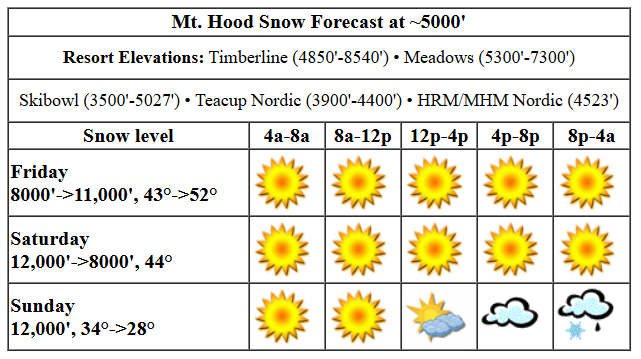
Friday looks warm and sunny. The free air freezing level will be 10,000′ this morning, 11,000′ this afternoon, and 12,000′ overnight. Temps start in the low 40s and rise to the low 50s. Wind will be W 20mph this morning becoming SW 10-15mph midday into the evening. Snow surface today will be hardpack and frozen granular early with corn snow and sticky slush later depending on how the snow started.
Saturday will be sunny all day. The free air freezing level will be above 10,000′ all day and will fall to 8000′ overnight. Temps max out in the low 50s and will fall to the low 40s in the afternoon before dropping to the mid 30s overnight. Same snow conditions as Friday. Wind: SW 10 in the morning, light/variable in the afternoon, and N 10 overnight.
Sunday will be sunny in the morning with increasing clouds in the afternoon. The free air freezing level will be 8000′ in the morning, 6500′ in the afternoon, and 5000′ after midnight. Models bring anywhere from a trace to half inch of precip overnight. With temps slowly falling, this is likely to start as mixed precip and switch to snow, but there’s too much uncertainty to guess how much snow, yet. Wind will be N 10 in the morning, NW 10-20 in the afternoon, and NW 20-30 after midnight.
Models have a bit of snow Monday with the snow level down around 2500′. By afternoon, the sky clears. For the next few days after that, there’s quite a bit of range in the precip amounts, but temps do look cold enough for snow. Models then hint at the possibility of an atmospheric river next weekend, but again, that’s only 50/50 at this point with the Euro way more aggressive about it than the GFS. So, get out there and enjoy the sunshine and warm weather today. T-shirt skiing in February is a rare treat!
Liking this forecast?
Was that helpful? I knew it was! Guess what? All of this crucial work – from your personal wind and snow reports to the invaluable TATAS updates – is made possible by my relentless efforts. Maintaining this labor of love isn’t easy. Each daily forecast takes hours. Website hosting, weather model access, and back-end admin work takes time and money. That’s where you come in.
YOUR CONTRIBUTION MAKES A DIFFERENCE
- SUPPORT ACCURATE, HYPER-LOCAL WEATHER FORECASTING
- ENABLE ACCESS FOR ALL, EVEN THOSE WITH LESS MEANS
- SUPPORT A COOL HUMAN WHO WORKS HARD SO YOU CAN PLAY
Take a moment to click one of the buttons below. Donate $19.99 or more (how much does this forecast enhance your life?) and get the email in your inbox. Whether it’s a renewing subscription (auto-renew) or a one-time donation, every contribution makes a real difference. Help me keep this labor of love alive, so we can all continue playing, commuting, and living in the Gorge with peace of mind and the best weather forecasts possible. Thank you!


Hood River, Oregon 97031


GORGE WIND FORECAST

Hi friends! Thanks for the day off yesterday. I needed that! Not much happens in wind land for the next two days, but models are optimistic about westerlies for both Sunday and Monday. Friday starts with easterlies at 12mph at both Iwash and Stevenson. The wind rises to 15mph at Iwash mid-morning before fading in the afternoon and falling below 10mph. Stevenson rises to 15-20mph and fades to 15mph. River flow over the last 24 hours was 85-172kcfs, river temp is 38.66F, and high temp forecast is 61F with sunshine all day.
Saturday starts with easterlies at 25mph at Iwash and 15mph at Stevenson. Iwash quickly fades and turns light/variable. Stevenson rises to 20mph mid-morning and fades to 10mph in the afternoon. High temp: 59F and sunny. Sunday sees offshore high pressure build during the day. We should start with 17-20 from Viento to Swell and see 22-25 from Stevenson to Doug’s in the afternoon. East of there, the wind might pick up to 13-16mph, but that’s about it. High temp: 54F and cloudy. Models suggest similar wind strength on Monday, but they shift it east. That said, about half of the euro ensemble members have a stronger day on Monday near Rufus, perhaps 25-28, which is right on the edge for “good”. We’ll keep a close eye on both Sunday and Monday as we get closer! See you on the river.
BARE BONES HOOD RIVER WEATHER FORECAST
Clear sky this morning stays that way. Temps start in the mid 30s and rise to the low 60s. Light easterlies. No rainbows. Saturday will be partly Nothing then sunny. Temps start in the upper 30s and rise to the upper 50s. Light easterlies early. Calm wind later. No rainbows. Sunday will be mostly cloudy. Temps start in the low 40s and rise to the mid 50s. Moderate westerlies. No rainbows.
TEMIRA’S AWESOME TRAVEL ADVISORY SERVICE
HYPERLOCAL WEATHER FORECAST FOR THE COLUMBIA GORGE
THE DALLES, HOOD RIVER, WHITE SALMON, TROUT LAKE, STEVENSON, CASCADE LOCKS, PARKDALE, ODELL, HUSUM, BZ, MILL A, WILLARD, GOLDENDALE, RUFUS, ARLINGTON, boardman
Good morning, neighbors! Gosh golly is it a nice day out there. Tomorrow looks a lot like today, and then we’re back to cloudy with a chance of meatballs… I mean cloudy with a chance of rain… from Sunday afternoon on into next week. Models have a lot of uncertainty about next week, but they generally look at least somewhat wet with a possibility of much wetter weather next weekend. Or not.
glenwood & TATAS EOOTD
Let’s check in with the 220 souls in chilly Glenwood: 26 degrees there this morning and sunny. TATAS Executive Order Of The Day: books cannot be banned unless they are merely vessels for hate speech. Signed with all the colors.
Now, let’s look at this sunny day, which has a dark cloud over it from the House passing a bill that gives $1.1 billion in tax cuts to the top 1% while directing the office that manages Medicaid to cut $880 billion and directing the office that manages SNAP (food stamps) to cut $230 billion. Note the important wording “directing the office to cut”. It doesn’t tell them what to cut, but it’s obvious what they’ll have to cut to partially balance out those tax cuts which won’t put a dime more in your pocket or mine, unless you’re in the 1%, in which case I implore you to share your wealth! But wait, there’s more. I did a little searching this morning. It costs the federal government about $7593 to insure one person on Medicaid through the private insurers that handle that program. If people are kicked off Medicaid, they will end up on the Exchange (most jobs worked by poor folks don’t offer health insurance), where the federal government will then pay subsidies of about the same amount *or more* to the same private insurers (PacificSource, Blue Cross, United Healthcare, etc) to provide insurance to the same person, but that insurance will have higher deductibles and limits and will cost the insured person more! Recap: It actually costs you, as the taxpayer, the same or more to kick people off Medicaid which provided much better coverage and much less hassle. End of today’s newsflash!
Your anti-authoritarian task today, should you choose to accept it is to: buy nothing. If you must buy something essential, do so at a local business, and pay with cash to avoid giving money to credit card issuers. Why the hell is this forecast talking about political stuff? Let’s set aside policy differences and simply look at the National Weather Service. You do not want me as your sole forecaster. You want NWS too, and you also want all the federally-funded weather models we use. Without those models, forecasts will really suck, as all we can do is look at the sky. That is not a good way to forecast. A 50% funding cut has been proposed to NWS. You do not want that. If you support this administration, you are supporting that. On to the weather!
today’s & Saturday
Sunshine today gives us max temps in the low 60s. Wind will be nearly calm most places with light easterlies in the usual spots. That wind dies down below 10mph at Iwash this afternoon, meaning you are welcome to head there for the first nude tanning of 2025. Another option, best done while clothed: there’s an anti-authoritarian protest on the 2nd street overpass in Hood River from 2-4pm today. Oh, and there’s one weekly at The Dalles post office at 4pm. Saturday: pretty darn similar to today, except the protest happens from noon to 1pm at the bottom of the 2nd Street stairs in Hood River.
sunday
Mostly cloudy weather with sunbreaks is forecast for Sunday, which won’t really live up to its name. So if you want to switch Saturday and Sunday, feel free. Temps max out in the mid 50s after a 40 degree start. West wind rises to 15-25mph between Stevenson and The Dalles with 10-15mph to the east. There’s a chance of some rain overnight, but models are all over the place on how much rain.
monday and beyond
Somewhat cooler, potentially showery weather (on the west side, anyway) is forecast for Monday. East: sun and breezy. Models then are kind all over the place on whether it’ll rain or not next week. Let’s call it on and off rain for now. About 50% of the members of the Euro give us another round of Pineapple Express next weekend, but the GFS, at this point, is less excited about that possibility. No boner on the GFS. Half-mast and uncut on the Euro, because, well, it’s European. Beyond that possibly warm/wet scenario, we have cooler, wetter weather (who – there are two bald eagles fighting outside my window right now!).
Valuable Advice for Gardeners Inhabiting Neighboring Areas: get out there and shove a thermometer in your soil. If it’s 40 degrees or more, you can go ahead and plant peas, radishes, arugula, and lettuce. You can also go ahead and start peppers indoors. You should already have started artichokes and onions. If not, you still can. Happy gardening. Safe travels. -TATAS
HEY! DON’T STOP READING! Is this community-focused forecast helpful to you? It sure is! It takes me a couple hours a day to write. Please join your friends and neighbors in contributing to keep it going. Venmo: @thegorgeismygym PayPal: twomirrors@gmail.com USPS: Temira / PO Box 841 / Hood River, Oregon 97031 You can test out the forecast subscription for a few days for free by clicking this link: https://subscribepage.io/YhevGc
