

MT HOOD WEATHER FORECAST
Hey skiers and snowboarders! Spring continues to dish up snowfall, and it’ll keep this up for a while. There are hints of warmer weather late next week, but between now and then… Mt Hood weather stays winter! We’ll have light snow this morning, a mostly dry Saturday, a dry first half to Sunday, and snow Sunday night. Dry weather returns early Monday and is followed by more snow into Tuesday. And after that? I’ll be gone for a month, but the skiing and snowboarding shall continue!
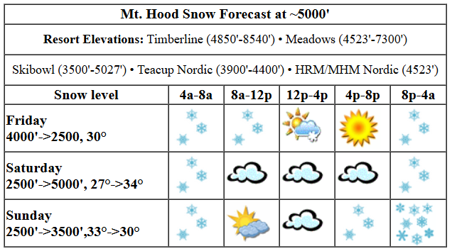
friday’s mt hood weather
Friday kicks off with light snowfall. By afternoon, we’ll have sunshine on the slopes. The snow level today will be around 4000′ in the morning. Overnight, it drops to 2500′. Temps at 5000′ will be around 30F all day. Up to 0.2” water equivalent (WE) is forecast this morning for 1-2” additional snow, probably the low end of that. Overnight, up to 0.1” WE is forecast for a trace to an inch. Wind will be SW 20-40 this morning, SW 20-35 this afternoon, and W 15 after midnight.
saturday’s mt hood weather
Saturday starts with clear sky up high and clouds to 6000′ or so. By afternoon: sunshine. High clouds return Saturday night. The snow level will be 2500′ in the morning, 4000′ in the afternoon, and 5000′ overnight. Temps will be around 27F in the morning and 34F in the afternoon. A trace of snow is possible early, and a trace of snow is possible late, but we’re not expecting any measurable accumulation. Wind: W 15 in the morning, light NW in the afternoon, and SE 20 after midnight.
Sunday kicks off with high clouds. Snow returns mid-afternoon. The snow level will be 4000′ early, 5000′ in the afternoon, and 3000′ after midnight. Temps start around 33F and fall to 30F in the afternoon and 30F overnight. About 0.2” WE is forecast in the afternoon for an inch or so of wet snow at 5000′. Overnight, models drop another 0.2” WE for a couple inches additional dense snow. Wind: SE 20 most of the day and SW 20-35 after midnight.
extended mt hood weather forecast
Monday starts dry and turns snowy with up to half a foot in the forecast. Snow continues into Tuesday afternoon with another half a foot possible. It’s worth noting that in spring, models tend to drop the precip amounts as we get closer to an event, so the probability of us actually getting a foot of snow isn’t all that great. That’s all for today. Have a great day on the snow!
Was that helpful? I knew it was! Guess what? All of this crucial work – from your personal wind and snow reports to the invaluable TATAS updates – is made possible by my relentless efforts. Maintaining this labor of love isn’t easy. Each daily forecast takes hours. Website hosting, weather model access, and back-end admin work takes time and money. That’s where you come in.
YOUR CONTRIBUTION MAKES A DIFFERENCE
- SUPPORT ACCURATE, HYPER-LOCAL WEATHER FORECASTING
- ENABLE ACCESS FOR ALL, EVEN THOSE WITH LESS MEANS
- SUPPORT A COOL HUMAN WHO WORKS HARD SO YOU CAN PLAY
Take a moment to click one of the buttons below. Donate $19.99 or more (how much does this forecast enhance your life?) and get the email in your inbox. Whether it’s a renewing subscription (auto-renew) or a one-time donation, every contribution makes a real difference. Help me keep this labor of love alive, so we can all continue playing, commuting, and living in the Gorge with peace of mind and the best weather forecasts possible. Thank you!


Hood River, Oregon 97031


GORGE WIND FORECAST

Hi friends! Spring weather and inconsistent, middling-strength wind continues until I leave for my retreat. For today, Friday, we start the day with very light onshore gradients and light wind. As a weather system swings through late morning or early afternoon,w easterlies pick up. We should see 12-15 from Stevenson to Doug’s from late morning into the evening. From Avery to Boardman, the wind rises to 19-23. A short period of stronger wind out east is possible but not guaranteed in the evening, but it will still be marginal out in the desert. River flow over the last 24 hours was 173-219, a big jump from recent readings, river temp is 46.8F, and high temp forecast is 55F. That’s 101.8F total! Expect rain in the morning on the west side and mostly clear sky everywhere this afternoon.
Saturday starts with very light west wind or calm wind. Midday brings 10mph or so from Stevenson to The Dalles. It won’t last long – we’ll be back to a glassy or near-glassy river in the afternoon. High temp: 55F with high clouds in the morning and partly cloudy sky in the afternoon. First thing in the morning on Sunday, you’ll find 30mph east wind at both Iwash (Rooster) Rock and Stevenson. Wind strength drops quickly and ends the day at 10-15mph. High temp: 58F with high clouds early and rain after 2pm. Monday starts with easterlies and turns westerly. Tuesday starts calm and ends with light westerlies. There’s a hint of stronger westerlies next Thursday, but ensembles are far from certain on this. It does look warmer, so that’s something! By then, I’ll be in western Mass, where it will be cold!
BARE BONES HOOD RIVER WEATHER FORECAST
Rain through midday, sun later. Temps start in the upper 40s and rise to the mid 50s. Light to moderate westerlies. 99% chance of rainbows. Saturday will be cloudy then partly cloudy. Temps start in the upper 30s and rise to the mid 50s. Calm wind followed by light westerlies followed by calm wind. No rainbows. Sunday starts with high clouds and turns rainy in the afternoon. Temps start in the mid 30s and rise to the upper 50s. Light easterlies. 15% chance of rainbows.
TEMIRA’S AWESOME TRAVEL ADVISORY SERVICE
HYPERLOCAL WEATHER FORECAST FOR THE COLUMBIA GORGE
THE DALLES, HOOD RIVER, WHITE SALMON, TROUT LAKE, STEVENSON, CASCADE LOCKS, PARKDALE, ODELL, HUSUM, BZ, MILL A, WILLARD, GOLDENDALE, RUFUS, ARLINGTON, boardman
Good morning, neighbors! Cool, intermittently drizzly weather continues all the way into next Tuesday, which happens to be when I take off for a month-long silent retreat. Silence, of course, includes letting go of the internet and forecasting and work. Naturally, the weather looks like it will turn warmer as soon as I leave, and it looks cold and dreary where I’m headed back east. So, you all are going to have to enjoy the beautiful Gorge spring and blossoms for me! Need a dry window? You’ll get it this afternoon through midday Sunday.
glenwood
Let’s say good morning to Glenwood: Good morning, Glenwood! It’s 42 degrees and cloudy there this morning. They must have had quite the rain shower yesterday – the station is reporting 0.34” rain over the last 24 hours.
New Indian food!
Most important news today: Hindustani, the new Indian food restaurant going in to the China Gorge space, opens today at 3pm!
today’s weather
You too may have a rain shower today! We’re expecting drizzle as far east as Hood River (lowlands) and Goldendale (hills) into late morning or early afternoon. Cascade Locks, situated in the western Gorge rainforest, holds on to some drizzle into the evening. High temps today will be in the mid 50s. After a calm start, the wind picks up to 10-15mph west of The Dalles and 20-25mph east of The Dalles starting mid-morning. A bit of instability hangs around too. We can’t rule out a thunderstorm, and nor can we rule it in. Speaking of instability… should you want to protest the governmental variety, the weekly protest at The Dalles Post Office is on this afternoon 4:30pm-5:30pm
Next big nationwide protest is the Hands Off protest on April 5th.
saturday’s gorge weather
Right. Weather for tomorrow. Saturday looks dry. The day starts cloudy in the west and east and clear near The Dalles. By afternoon, the weather will be partly cloudy everywhere which of course means at least some sun everywhere, yay. Wind stays under 15mph out of the west all day, and it’ll be calm early (spray, baby, spray) and late. High temp: 55F after a 40 degree start.
sunday’s gorge weather
Sunday: dry through about 2pm. Rainy as far east as Lyle starting mid-afternoon and rainy to Amayah’s, the location formerly known as Biggs, in the evening. South Wasco and Sherman Counties join the evening rain and stay drizzly through Monday morning. Sunday’s high temp: 58 degrees or so after an upper 30s start. Sunday’s wind: E 30-35mph near Stevenson and Iwash (cock) Rock until early afternoon. Easterlies at 10-15mph all the way from Iwash to Boardman in the afternoon. Rain returns midday morning and continues through Tuesday. Models hint at a bit of a warming trend (not as hot as the last one) starting late next week. You lucky dogs. It’s supposed to be cold, potentially really cold, where I’ll be back east. Safe travels. -TATAS
