

Support it with a contribution!

Thank you for using this forecast. Writing it takes 60-120 minutes a day; I can only keep it going with your generous financial support. Make a contribution or subscribe and get it in your inbox with bonus material. What’s that cost? Not $99 a year. Nope. Not $49. Contribute $19.99 or more, and you’re on the list for a year. People are added to this list on Thursday and Sunday. Thanks for your patience! Click below to contribute and keep the forecast going for everyone, nearly every day.
Click here to use your PayPal
Venmo: @theGorgeismyGym
Snail Mail: Temira Lital, PO Box 841, Hood River, Oregon 97031
(note: I am not a non-profit entity. The only way to accept credit cards with a user-defined amount is to use the ‘donate’ button. Thanks for understanding!)
Auto-renewing subscription. New! Awesome!
The Forecast
Today’s Gorge Wind – these are ranges for the average speed, not a predicted wind range. =)
Your favorite beach
Dawn
Patrol
9am-
11:30a
11:30a-
3pm
3pm-
dusk
Rooster Rock
cool
clouds
chill
buns
Steven’s Locks
13-16
13-16
16-20
G22-26
Viento
13-16
13-16
16-20
G22-26
Swell-Hood River
13-16
13-16
16-20
G22-26
Lyle to Doug’s
11-14
11-14
16-20
G22-26
Rufus, etc.
23-26
23-26
23-26
26-30
Roosevelt & Arlington
23-26
23-26
23-26
26-30
Patrol
11:30a
3pm
dusk
Gorge Wind Forecast
Westerlies stick around in the “strong” range somewhere in the Gorge for the next few days before backing off into the teens to start next week. Temps during the period will remain seasonable or slightly below – no sign of hot weather (90+) out there at all! Before I forget, I am on call from tonight at 5pm to midnight Saturday. Depending on how my shift goes, I may or may not be able to do a forecast the next two days.
Looking at Friday, we see deep marine clouds in the western half of the state with a low moving inland from the NW. Westerlies increase as the low makes it to Central Oregon this afternoon. Morning gradients: 0.11 pdx-dls and 0.06 dls-psc. The day starts with 11-14 at many places with 24-27 at Viento and Rufus. Keep an eye on Rufus today. By midday, westerlies rise to 24-27 all the way from Avery to Threemile with gusty 13-16 under partly cloudy sky in the western Gorge. It’ll take until late afternoon for the strongest wind to materialize today: after 2pm, you’ll find 26-30 from Rowena to Threemile with gusty 22-26 between Stevenson and Mosier. Today’s smoke caveat: dense elevated smoke east of Biggs will limit heating potential in the desert, and this could limit the afternoon wind strength. River flow is 125kcfs. River temp is 71F. High temp Hood River: 69F. Biggs: 74F.
Westerlies continue on Saturday as a low moves eastward and increases gradients. Hood River should be cloudy all day, meaning you’ll be driving east for the best wind. Sounding models suggest clouds all the way to Maryhill. That’s not a great sign for wind quality. That said, models predict 14-17 between Stevenson and The Dalles in the morning with 20-23 out east. Afternoon westerlies rise to 25-28 between Lyle and Threemile while the western Gorge drops to gusty 11-14 thanks to persistent clouds. That said, those clouds in the sounding model are worrisome, and could lead to low-quality, under-performing wind. High temp: 73F for Hood River and 78F for Biggs.
On Sunday, a trough of low pressure is forecast to move into BC and increase gradients in the afternoon. Morning wind will be 13-16 or so from Viento to Arlington with 5-10 at Stevenson. Midday: 20-23 from Viento to Mosier with 13-16 at Stevenson and east of The Dalles to Arlington. Afternoon gradients smash together over the western Gorge, leading to 25-28 mid-afternoon onward between Viento and Doug’s. East of there: 20-23 to Arlington. High temp: 73F for Hood River under sunny sky.
Looking at the beginning of next week, we have 14-17 on Monday and 11-14 on Tuesday with a chance of stronger wind late in the day. No promises that forecast will actually hold. What we don’t have in the next two weeks or so is any sign of extreme heat. Nothing over 90F. The only day that might be too calm for wind sports is Tuesday, but even that day has potential. Enjoy!
Coast, Jones, Coast
Coast (north/central/south, waves. Wind direction north unless otherwise noted. Swell forecast from NWS.) Friday: NW5-10/N5-10/N30-40, NW swell 8′ at 9 second. Saturday: NW5/LTNW/N30-35, NW 6′ @ 9. Sunday: NW5-10/N10-15/N30-35+, NW 6′ @ 8. Jones Friday: LTW. Saturday: LTW. Sunday: 7-10. Sauvie’s Friday: LTNW. Saturday: LTV. Sunday: NNW7-10.
Mt. Hood Weather forecast
On vacation unless some wintry weather happens.
Hood River Weather Forecast
Partly cloudy sky this morning stays that way. Temps will be near 60 early and near 70 later. Moderate to possibly strong westerlies. No rainbows. Saturday will be partly cloudy, then cloudy, then partly cloudy again. Temps will be in the mid 50’s early and low 70’s later. Moderate westerlies. No rainbows. Sunday starts partly cloudy and turns clear. Temps will be in the mid 50’s early and low 70’s later. Moderate westerlies become strong in the afternoon. No rainbows.
Looking for a complete Columbia Gorge forecast? Looking for more humor in your weather? Obscenities? You’re looking for my TATAS: Temira’s Awesome Travel Advisory Service on Facebook.
Cycling
SDS (Whoopdee, Underwood), BLC, HFM, DGS, and Kreps Land (Hospital Hill) are now closed until the end of fire season. It is also vital that people respect this closure to maintain positive relationships between the landowners and trail users. DNR land in Eastern Washington (Buck Creek / Nestor Peak) is all closed to recreation due to fire danger.
Open trails: Post, Falls Creek, Lewis River, Sandy Ridge, Columbia Hills, Gorge 400, Plains of Abraham / Ape Canyon. 44 Road: Eightmile, Fifteenmile, Bottle Prairie, Dog River, Superconnector, Cedar, Knebal, Cooks Meadows, 450 to the top, Gunsight, Underhill. Siouxon has reopened. Huffman: not sure.
Maple Road in Post Canyon is closed. DO NOT drive past the closed signs. If you do so, you will jeopardize TRAIL access for the entire summer. This is the road that runs to the west, just north of the Binns/Riorden intersection. Also, the trail from the bottom of Post Canyon to Seven Streams Staging Area is now closed. It’s on private land. Respect the closure.
Local Events
This weekend, Friday through Sunday, is Pacific Crest Trail Days at Thunder Island in Cascade Locks. It’s a great place to see all the latest, greatest camping gear.
IFPL 3 restrictions west of Highway 35 went into effect on 7/16. No more motorized use in Post Canyon trails. Mountain View Cycles women’s ride is every Thursday, bottom of Post at 5:30pm. They have an all-genders ride at 6pm on Wednesday, end of the pavement on Post Canyon Road. Their shop road ride leaves at 9am on Saturday for a 2 hour ride. Dirty Fingers has the Post n’ Pint on Thursday evenings at 5:30pm from the shop. They also have the women’s Post n’ Pinot Wednesday evening at 5:30pm from the shop. Oregon E-Bikes has ladies’ rides at 7:30am Sunday and Monday. The Small Boat Group does paddles every Thursday evening at 6pm at the Hatchery.
Other weekly events. Normally on Tuesday night there’s meditation with the Pacific Hermitage Monks at 5:15 (1 hour) and 6:30 (30 minutes followed by a talk) at Yoga Samadhi in White Salmon. In-person meditation is on “pause” due to the recent Covid surge. It will happen on the Pacific Hermitage YouTube page at 6:30. Triathlon practice with the Tri Club is Tuesday at 6pm at West Mayer State Park. Sailboat races happen Wednesday night from the Hood River Marina. There are also lesser races on Friday nights. Cheno’s workout is every Saturday at 10am at the Ferment Lawn in Hood River ($10). Families in the Park starts August 5th at Jackson Park and runs for several weeks on Thursday evening.
Sprinter Van of the Week!
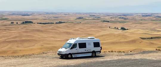 Click here for the Sprinter Van map of the world!!!
Have an awesome day!
Click here for the Sprinter Van map of the world!!!
Have an awesome day!
