

For almost 30 years, Temira (they/them) has been making the most of what the Gorge has to offer: riding river swell on a foil or windsurf board, carving fresh lines through the snow, and cycling all the gravel and pavement and trails. This is Temira’s playground, their gym… their life’s work. That’s why in 2006, Temira took it upon themselves to create the most accurate, hyper-local weather forecasts possible. Inaccurate predictions had left too many fellow adventurers caught off-guard and in harm’s way. Temira was determined to change that. Today, Temira’s forecasts have become an essential resource for thousands of skiers, snowboarders, wind sports enthusiasts and travelers through the Gorge. With their guidance, you can plan ahead, time your sessions perfectly, and stay safer on the water, snow, and trails. But the story doesn’t end there. Temira also authors the TATAS Facebook page – the Gorge’s premier source for microclimate forecasts. When winter storms, extreme heat, or other hazardous conditions (avalanches on SR-14 and I-84, for example!) threaten, this community lifeline becomes a vital resource for locals and visitors alike, helping to keep everyone safe.
The best snow forecast for Mt. Hood.
The best weather forecast. Period.Meet Temira,
your Gorge and Mt. Hood forecaster
Go ahead – support Temira
All of this crucial work – from your personal wind and snow reports to the invaluable TATAS updates – is made possible by Temira’s relentless efforts. But maintaining this labor of love isn’t easy. Each daily forecast can take hours to research and analyze. The website, forecast model subscriptions, and back-end admin work take time and money. That’s where you come in.
Your Subscription Makes a Difference:
✓ Support accurate, hyper-local weather forecasting
✓ Enable access for everyone, even those with less means
✓ Support a cool human who works hard so you can play hard
By becoming a contributing member, you’re not just supporting Temira’s passion project – you’re investing in the safety and well-being of the entire Gorge community. Your financial support ensures these essential forecasts remain accessible to all, free of charge.
So please, take a moment to click one of the buttons below. Donate $19.99 or more (how much does this forecast enhance your life?) and get the email in your inbox. Whether it’s a monthly subscription or a one-time donation, every contribution makes a real difference. Help Temira keep this labor of love alive, so we can all continue playing, commuting, and living in the Gorge with peace of mind and the best weather forecasts possible. Thank you!
Electronic payments not your thing? Temira / PO Box 841 / Hood River, OR 97031


Mt. Hood Snow Forecast
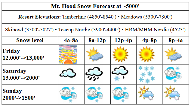
Hi skiers and snowboarders! One last day of mostly sunny weather, and then we’re in for a bit of a roller coaster ride this weekend: rain Saturday morning, snow Saturday afternoon, and snowy, stormy weather all day Sunday. That’s followed by a few days of warmer, dry weather for the first half of next week. And then… finally… we return to a cooler, snowy pattern for at least a few days!
Friday will be mostly sunny with a few high clouds scattered about. Snow surface: mostly hardpack with some areas of transitional snow and scattered granular/corn. The free air freezing level rises to nearly 13,000′, and temps max out near 50F. Wind: Light SW early rising to WSW 15 this afternoon and WSW 30 after midnight.
Friday looks sunny to start and high overcast. It also looks warm: temps start near 40 and rise to 50 before dropping overnight. The free air freezing level will be 11,000′ in the morning and will slowly rise to 12,000′ or more overnight. Wind: variable to 10 early, W 15 in the afternoon, and WSW 30-35 after midnight.
A wet and windy cold front slams into Mt. Hood on Saturday morning. A period of pouring rain in the morning gives way to snowy, blowy conditions in the afternoon. The snow level falls from 13,000′ early to 9500′ around noon and 3500′ in the afternoon. Overnight, it drops to 2000′. About 0.7” rain/mixed precip falls before the transition to snow around 2pm. We then see 0.2” to 0.3” water equivalent (WE) as snow overnight for 2-3” new snow. While there won’t be much moisture around, orographics (terrain-enhanced precip) will be doing its best to help us out; we could see 30-50% more snowfall if we’re lucky. Wind: WSW 30-35 in the morning turning to WNW 35-40 in the afternoon and W 45-50 overnight.
Sunday will be snowy and blowy with scattered sun breaks possible late. The snow level will be 2000′ in the morning, 2500′ in the afternoon and down around 1500′ as the sky clears overnight. Temps at 5000′ will be in the mid-upper 20s. About 0.3” to 0.6” WE is forecast during the day for 4-7” decent quality, relatively dry powder. Overnight, another 0.2” to 0.3” WE is forecast for another 2-4” powder. Once again, orographics could give us 25-40% more snow. Fingers crossed! Wind: W 45-50 in the morning, WNW 35-40 in the afternoon, and N 10 overnight. That’s enough wind to shut down the highest lifts and potentially affect lift speeds on some of the lower lifts. It definitely won’t be a total shutdown – just normal Mt. Hood storm skiing. Fun!
Monday looks clear and sunny and cool with excellent packed powder and powder conditions. The free air freezing level (FAF) will be 1500′ in the morning, 4000′ in the afternoon, and 6500′ after midnight. Temps at 5000′ rise to the low-mid 30’s in the afternoon. Wind: N 10 in the morning, NW 10-15 in the afternoon, and light NW overnight. Sunny, 40 degree weather is forecast for Tuesday with light wind. Dry, warm weather persists for a few days. Precipitation returns on Thursday or Friday. There seems to be plenty of snow in the forecast at the end of next week and into the weekend. Details, of course, aren’t yet clear. Have a great day on the snow today!
[DISPLAY_ULTIMATE_SOCIAL_ICONS]Gorge Wind Forecast

Hi friends! Friday brings another round of nuking east wind. In a fun twist, both weekend days carry a good chance of “enough” west wind to get folks on the river. There’s still quite a bit of range in the ensemble predictions, especially on Saturday, but let’s just dive in and talk about it, shall we? Friday starts with pressures of 30.39/30.57 for a 0.18 easterly gradient. Iwash (Rooster) Rock was at 54mph when I woke up, Stevenson at 31mph, and Viento at 20mph. That’s the morning. The wind fades a bit this afternoon and lands at 20mph at Stevenson and 30mph at Iwash. River flow over the last 24 hours was 76-164kcfs, river temp is 48.2F, and high temp forecast is in the upper 30s with sunshine in the windy zone.
Before I forget… the Big Winds Locals Only Sale is Saturday – doors at 9am. A very powerful, very wet cold front is headed this way on Saturday. Sometimes this setup works out great, and sometimes it fizzles. I’m still trying to work out which cold fronts are windy and which are not. So… here’s the best case scenario: for about 90 minutes ahead of the incoming rain (probably mid-morning) we have a shot at 24-27 from Stevenson to Hood River followed by, as the rain moves east, 28-32 from Avery to Arlington. When the rain hits, areas west of The Dalles drop to gusty 20-23. And by rain, I mean “downpour”. High temp: 48F. Offshore high pressure on Sunday keeps the westerlies going. Areas west of Rowena will be intermittently rainy, but we should still see westerlies at gusty 19-22 from Stevenson to Mosier all day. From Lyle to Boardman, there’s a shot at 26-29 for a few hours mid-morning into early afternoon. Models suggest that high pressure building inland will drive the wind speed down in the afternoon. Watch the Swell-Doug’s zone for a shot at over-performing conditions. High temp: 47F. Despite it being Friday as I write this, the weekend forecast is likely to change tomorrow morning. Be safe out there today!
Very basic Hood River weather forecast
Don’t plan your life around this. You really should read Temira’s Awesome Travel Advisory Service on Facebook for a detailed weather forecast.
For Friday: Nothing. Temps start in the mid 30s and stay there. Light easterlies. 0% chance of rainbows.
Saturday starts with Nothing, turns very wet and windy, and ends the day rainy and cloudy. Some areas will see freezing rain prior to the wind turning westerly. Temps start in the low-mid 30s and rise to the mid 40s. Strong westerlies. 93% chance of rainbows.
Sunday will be cloudy and showery then partly cloudy. Temps start in the upper 30s and rise to the upper 40s. Moderately strong westerlies. 99% chance of rainbows.
Stay Connected with Local Events!
Want to know what’s happening in and around the Gorge? Check out my curated calendar of local outdoorsy events!
Local-ish Outdoorsy Events Calendar
Know of an outdoor-related local-ish event? Let me know! If you don’t tell me, I don’t know about it!
Cycling Update
Right now, as of 12/5, there’s some great riding! It’s frozen up high and good dirt down low. Get it before the rain returns. When it’s wet and muddy, [lease don’t ride, or you’ll do significant trail damage. Then peeps have to fix your mess rather than building new trails. Nobody wants that! Everyone wants new trails. Be a good steward, and pick a different activity
Remember: E-bikes are not allowed on USFS non-moto trails. They are allowed on moto trails.
Make Today Awesome!
Whether you’re shredding fresh powder on Mt. Hood, surfing swell on the Columbia, or just enjoying our stunning home… remember that every day here is a gift. Make the most of it.
Have an absolutely epic day out there!
~ Temira
