

GORGE WIND FORECAST
today’s gorge wind forecast
Hi friends! Today’s gorge wind forecast has us with another relatively light wind day here in the Gorge. There’s a chance of just enough wind late afternoon to get you on the river. Stronger wind is forecast over the weekend, but the quality and predictability will be compromised by lots of moving parts. Westerlies continue Monday afternoon, and a couple of stronger wind days are forecast for Tuesday and Wednesday. After that: continued westerlies, if you believe the ensembles, which I do!
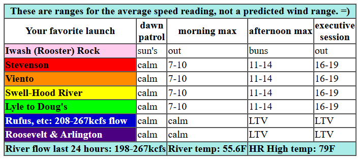
Friday kicks off with completely flat gradients through the Gorge and very little wind to speak of. With weak high pressure offshore and a supportive thermal gradient forecast for the afternoon, we’ll see the wind pick up to the “maybe enough” range. A slow build this morning meets midday with 10-13mph from Stevenson to Mosier. Westerlies slowly increase to 16-19 between Stevenson and The Dalles this evening with the strongest wind forecast for the executive session. River flow over the last 24 hours was 198-267kcfs (Rufus: 208-267kcfs), river temp is 55.6F, and high temp forecast is 79F with partly cloudy sky this afternoon.

tomorrow’s gorge wind forecast
Saturday brings an approaching frontal system to our zone with a low approaching BC and high pressure off NoCal. Generally speaking, this setup usually gives us an early, short session near the Hatch with a quick shift east for the strongest wind. Indeed, this is what models suggest: Dawn Patrol at 20-23 from Stevenson (or Viento) to Arlington. Mid to late morning, the wind falls to 17-20 from Stevenson to Hood River (Viento will probably over-perform) with up-and-down 25-28 from Mosier to Threemile. The Lyle-Doug’s stretch could touch 27-30mph intermittently. After 5pm, areas east of Mosier drop to gusty 22-26 while the Swell zone surges back with gusty 19-22. High temp: 71F with increasing clouds as the day goes on.
extended Gorge wind forecast
That frontal system swings through early on Sunday, and it’s replaced by a weak low off the coast. Not ideal. Early wind will be 7-10mph out of the west all through the Gorge. We’ll see a slow build to 14-17 between Stevenson and Mosier with gusty 19-23 from Lyle to Rufus or maybe Arlington after 2pm. High temp: 65F with clouds in the morning and clearing sky later.
Monday starts calm and rises to the low-mid 20s, but we’ll be fighting atmospheric instability which makes the day highly unpredictable. Ensembles then give us a couple days of stronger wind for Tuesday and Wednesday. They’ve been switching back and forth between which will be the stronger, steadier day, which means I’ve been bouncing my metro area commitment between the two. With more moving parts forecast for Tuesday, Wednesday currently holds an edge on wind speed and quality in my mind. Either way, both days will get you on the river. Beyond that: ensembles keep us in west wind of some sort for the foreseeable future. High temps Sunday through the end of next week will be running around 60 degrees, and there are several days with a chance of showers. All-in-all – pretty optimistic forecast we’ve got here. Make sure you schedule some time for rest too! See you on the Nch’i Wana!
Was that helpful? I knew it was! Guess what? All of this crucial work – from your personal wind and snow reports to the invaluable TATAS updates – is made possible by my relentless efforts. Maintaining this labor of love isn’t easy. Each daily forecast takes hours. Website hosting, weather model access, and back-end admin work takes time and money. That’s where you come in.
YOUR CONTRIBUTION MAKES A DIFFERENCE
- SUPPORT ACCURATE, HYPER-LOCAL WEATHER FORECASTING
- ENABLE ACCESS FOR ALL, EVEN THOSE WITH LESS MEANS
- SUPPORT A COOL HUMAN WHO WORKS HARD SO YOU CAN PLAY
Take a moment to click one of the buttons below. Donate $19.99 or more (how much does this forecast enhance your life?) and get the email in your inbox. Whether it’s a renewing subscription (auto-renew) or a one-time donation, every contribution makes a real difference. Help me keep this labor of love alive, so we can all continue playing, commuting, and living in the Gorge with peace of mind and the best weather forecasts possible. Thank you!


Hood River, Oregon 97031


JONES BEACH, SAUVIE ISLAND, & COAST FORECAST
Wind northerly unless otherwise indicated. For coast, it’s North/Central/South with the “central” at approximately Florence. Swell forecast from NWS for central coast. Friday: 10-15/10/15, W swell 5′ at 11 seconds. Saturday: SW15/LTW/LTN, W 4′ @ 10. Sunday: SW15/S20/S20-25, W 6′ @ 9. Jones Friday: 16-19. Saturday: LTW. Sunday: LTW. Sauvie Island Friday: 7-10. Saturday: 10-13. Sunday: LTW.
BARE BONES HOOD RIVER WEATHER FORECAST
Mostly clear sky this morning adds a few high and mid clouds later. Temps start in the low 40s and rise to the upper 70s. Light westerlies this morning. Moderate later. No rainbows. Saturday will be mostly cloudy. Temps start near 50 and rise to the low 70s. Moderately strong westerlies. No rainbows. Sunday will be cloudy then partly cloudy with a chance of light drizzle. Temps start in the upper 40s and rise to the mid 60s. Light westerlies in the morning. Moderate later. 86% chance of rainbows.
TEMIRA’S AWESOME TRAVEL ADVISORY SERVICE
HYPERLOCAL WEATHER FORECAST FOR THE COLUMBIA GORGE
THE DALLES, HOOD RIVER, WHITE SALMON, TROUT LAKE, STEVENSON, CASCADE LOCKS, PARKDALE, ODELL, HUSUM, BZ, MILL A, WILLARD, GOLDENDALE, RUFUS, ARLINGTON, boardman
Good morning, neighbors! Another sunny, warm, buttock-tanning day is on tap today. Get it now, because high temps fall to 70 on Saturday and drop into the 60s and stay there starting Sunday. More clouds are forecast, and we even have a chance of a little drizzle during several of the upcoming days. It won’t be enough to make a difference in soil moisture, but it’ll be enough to shift your perspective a bit.
glenwood
But there’s no rain today. Wait, I almost forgot about Glenwood! It’s 29 degrees there this morning. Trout Lake is at 31, and Centerville is at 32, and that’s it for freezing temps as best I can tell. With 850mb temps forecast to dip as low as -2C several days next week, we’ll be keeping a close eye on frost potential.
today’s gorge weather forecast (it’s Friday)
Back to today, Friday: we all warm up to the upper 70s to low 80s today. Hopefully we can warm up to each other a little bit too rather than eyeing each other with suspicion. My new thing is that I just smile and say hi or wave to everyone. Going forward, I’m going to assume that everyone wants to be treated with friendliness. If you care to join me in this, that’d be cool. Back to the weather, or at least the wind: westerlies rise from near-zero this morning to 15-20mph this afternoon west of The Dalles. To the east: light wind. This will put the Wind Johnnies on edge, as it’s right on the edge of enough/not. Be extra friendly to them today, as they might be stressing out!
tomorrow’s gorge weather forecast
Saturday morning brings high clouds all the way east to the Tri-Cities area. East of there, models have clear sky. Somewhere under those high clouds, we’ll have a spectacular sunrise. Morning temps will be near 50. Afternoon: low 70s (that’s PERFECT – as you know, TATAS has a 65-75 degree bias). West wind starts at 20mph from Stevenson to Arlington and rises to 25mph east of Hood River mid to late morning. We’ll keep the high clouds all day, and we’ll add some mid-level clouds west of The Dalles. No rain. You’ll have to wait for Sunday for that.
Sunday’s gorge weather forecast
Models give us a little drizzle west of The Dalles, east of The Dalles to Celilo, and in South Wasco county on Sunday morning. Drizzle sticks around west of Hood River into the evening, but the rest of us will be dry for most of the day. Clouds in the morning give way to sun in the afternoon. West wind starts at 5-10mph. It rises to 20-25mph east of Mosier with 15-20mph west of Mosier in the afternoon. Highs only make it into the low 60s on the west side with upper 60s to the east.
extended gorge weather forecast
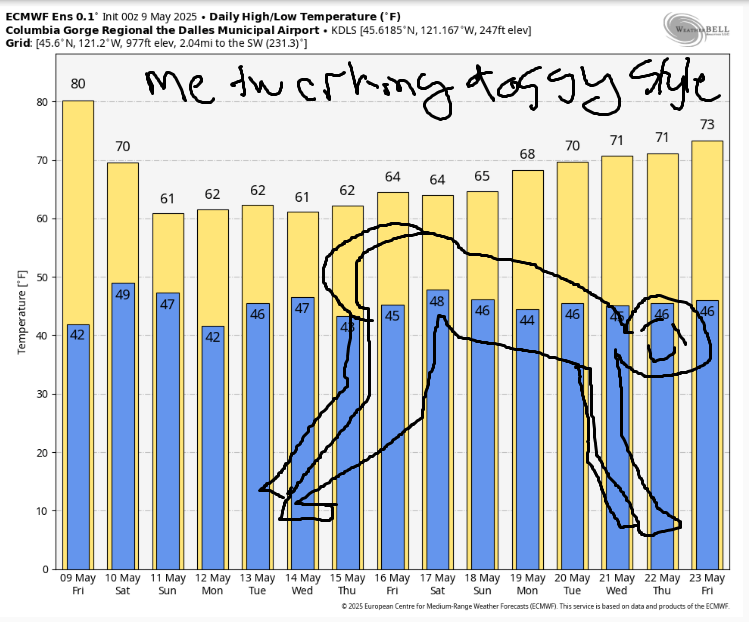
Drizzle chances with highs in the low 60s are planned for the first few days of next week. After that: dry with low 60s. Notable next week is the wind potential on Tuesday and Wednesday: those are not going to be spray days, and they will be windy enough to send your rubbish bin tumbling eastward in search of a new home. Wind Johnnies will also be tumbling eastward in search of giant river swell and camaraderie as they pack as many people and as much gear as possible into a cargo van. It’s like Tetris, only more expensive and with far more laughter. Five stars, highly recommend. I’ll get yous a video one of these days if I can when we try and set a record. I believe it’s currently 13 people and gear in on van. Don’t try that at home, and also, I thought about trying to draw a picture of that, but no, I’m not that talented. Instead, you get me twerking doggy style on the upcoming temps. Safe travels. -TATAS
HEY! DON’T STOP READING! Is this community-focused forecast helpful to you? It sure is! It takes me a couple hours a day to write. Please join your friends and neighbors in contributing to keep it going. Venmo: @thegorgeismygym PayPal: twomirrors@gmail.com USPS: Temira / PO Box 841 / Hood River, Oregon 97031 You can test out the forecast subscription for a few days for free by signing up below. Easy! Do it!
