

MT HOOD WEATHER FORECAST
Hey skiers and snowboarders! Ma Nature wasn’t quite cooperating as I was writing this forecast – our Mt Hood weather morning started with mixed precip at 5000′. But temps will drop a few degrees during the day, and we’ll still pick up some snow. That’s followed by dry weather Saturday and then a collapse into warm, drizzly weather on Sunday. Don’t despair – that rain will help ease the transition to corn snow for the warm, sunny weather forecast next Monday, Tuesday, and Wednesday.
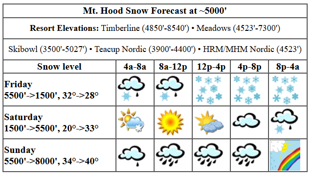
It’s a disappointing start to Friday with the snow level somewhere above 5000′. Snow surface: wet pack. Do not panic! The snow level will drop to 4000′ midday, 3500′ this afternoon, and 1500′ after midnight. Temps at 5000′ will be right at 32F this morning, they’ll drop to 28-29F this afternoon, and fall to 20F or so overnight under mostly clear sky. During the day, 1.3” water equivalent (WE) is forecast for 8-11” dense new snow. Another 0.5” WE arrives overnight for 5-7” powder. Wind today will be W 45 in the morning, W 30-35 for the rest of the daylight hours, and WNW 35-40 overnight.
Saturday kicks off clear to partly cloudy with fresh powder on the ground. Mixed precip returns in the evening. The resorts are almost certain to park out on Saturday, so please carpool or take the CAT bus. The free air freezing level starts the day around 1500′, rises to 3000′ in the afternoon, and climbs to 5000-5500′ overnight. Fortunately, the system bringing this warm air and moisture will only clip us; most of the moisture stays north. About 0.1” to 0.2” mixed precip, becoming drizzle, is forecast overnight. Wind: WNW 35-40 early, WSW 10-15 in the afternoon, SW 10-20 in the evening, and WSW 30-35 overnight.
extended mt hood weather forecast
Sunday looks warm, wet, and windy. Uncertainty still exists in the amplitude of the warmth, wind, and moisture. As of right now, we’re looking at around 0.5” to 1.0” rain with temps in the upper 30s and wind between 30-50mph out of the west. Models do hint at enough wind in the afternoon to put at least some lifts on standby. Drizzle continues into Monday morning before dissipating and leaving warm, high overcast conditions on the slopes. Tuesday and Wednesday will likely be very warm, 50 degrees or warmer, with sunshine. We’re back to winter on Wednesday night. Have fun on the snow!
Was that helpful? I knew it was! Guess what? All of this crucial work – from your personal wind and snow reports to the invaluable TATAS updates – is made possible by my relentless efforts. Maintaining this labor of love isn’t easy. Each daily forecast takes hours. Website hosting, weather model access, and back-end admin work takes time and money. That’s where you come in.
YOUR CONTRIBUTION MAKES A DIFFERENCE
- SUPPORT ACCURATE, HYPER-LOCAL WEATHER FORECASTING
- ENABLE ACCESS FOR ALL, EVEN THOSE WITH LESS MEANS
- SUPPORT A COOL HUMAN WHO WORKS HARD SO YOU CAN PLAY
Take a moment to click one of the buttons below. Donate $19.99 or more (how much does this forecast enhance your life?) and get the email in your inbox. Whether it’s a renewing subscription (auto-renew) or a one-time donation, every contribution makes a real difference. Help me keep this labor of love alive, so we can all continue playing, commuting, and living in the Gorge with peace of mind and the best weather forecasts possible. Thank you!


Hood River, Oregon 97031


GORGE WIND FORECAST

Hi friends! Gusty, unreliable wind continues for the next few days. With the arrival of warm weather, things settle down a bit next week. Keep an eye on Tuesday for marginal easterlies, and keep an eye on Wednesday for a decent chance at westerlies. Friday kicks off with light onshore gradients. Wind remains under 10mph west of Avery into late afternoon. From Avery to Arlington, gusty 18-22 is possible during the day today. Models suggest stronger westerlies after 5pm as a system moves in, but they also suggest pouring rain all the way out to the desert. So, it’s possible that wind will not materialize, or if it does, it’ll be off-the-charts up-and-down. Definitely not an ideal setup today. River flow over the last 24 hours was 96-162kcfs, river temp is 44.2F, and high temp forecast is 51F with rain.
Saturday doesn’t look much better. The day starts with 11-14 from Stevenson to The Dalles and gusty 16-19 from Avery to Boardman. Eastern Gorge sites drop to 11-14, and the west side drops below 10mph in the afternoon. High temp: 53F with clouds, then some sun, then clouds. Another system approaches on Sunday but stalls west of us. Calm wind starts the day. Westerlies pick up to 15-25mph from Iwash (Rooster) Rock to Viento in the afternoon but probably don’t make it farther inland. High temp: 55F and drizzly.
extended gorge wind forecast
Monday: light and variable. Tuesday: E 25-30 and 70 degrees! Wednesday has a chance at afternoon or evening thermals as a colder system approaches from the west. The setup isn’t ideal (yet again), but the thermals could be enough to get us on the river along with temps in the upper 60s. That sounds amazing. Hope to see you out there!
BARE BONES HOOD RIVER WEATHER FORECAST
Drizzle this morning. Heavy rain this evening. Temps start in the mid 40s and rise to the low 50s. Light westerlies. 38% chance of rainbows. Saturday will be cloudy to start, partly cloudy midday, and cloudy later. Temps start in the upper 30s and rise to the low 50s. Moderate westerlies. 11% chance of rainbows. Sunday will be cloudy with drizzle. Temps start in the low 40s and rise to the mid 50s. Calm wind. 16% chance of rainbows.
TEMIRA’S AWESOME TRAVEL ADVISORY SERVICE
HYPERLOCAL WEATHER FORECAST FOR THE COLUMBIA GORGE
THE DALLES, HOOD RIVER, WHITE SALMON, TROUT LAKE, STEVENSON, CASCADE LOCKS, PARKDALE, ODELL, HUSUM, BZ, MILL A, WILLARD, GOLDENDALE, RUFUS, ARLINGTON, boardman
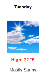
Good morning, neighbors! TGIF! There’s a good bit of drizzle in the forecast through Monday morning, but hope returns in the form of 70 degree sunshine on Tuesday. We’ll also have some dry weather Saturday daytime. Plan around that. Starting next Wednesday night, we fall back into damp weather and stay there at least until I leave for my month long retreat on 4/1.
That is not an April Fool’s joke.
glenwood & tatas eootd
Let’s check in with Glenwood this morning: 43 degrees, overcast, and damp. TATAS Executive Order Of The Day: The standard judicial ethical code shall be applied to SCOTUS, and there shall be enforceable penalties for violations, up to and including removal. The code shall be enforced by the American Bar Association.
friday (today)
Speaking of SCOTUS, make sure your scrot-us is protected from the damp today. Damp it shall be – drizzly to Hood River all morning, and pouring rain all the way to the Arlington Triangle this evening. While it’ll be raining all day in the western Gorge, it’ll be absolutely pouring from 11am to 8pm. Expect an unpleasant drive to/from the metro area. SW and Sherman Counties: you too shall get a soaking tonight. Temps today max out near 50 degrees. Wind will be light in the morning, light west of The Dalles in the afternoon, and W 15-25mph east of The Dalles this afternoon. Overnight, westerlies pick up all through the Gorge, but shouldn’t reach damaging strengths.
One last thing: the snow level will drop to 1500-2000′ late tonight. Parkdale, Mill A, Willard, Snowden, Trout Lake, York Hill, and Parkdale could pick up 0.5” to 1.5” wet snow before the precip stops.
saturday
If you’re in the just the right spot Saturday – under the clouds but within site of east side clearing – you’ll have a gorgeous sunrise. We should all have a period of sun midday prior to clouds returning in the afternoon. Rain returns in the evening making it to Cascade Locks around 8pm and to The Dalles round 11pm. High temp: 53F or so. Wind will be W 10-15mph.
sunday
It’s not quite clear exactly how far south Sunday’s rain will extend. It’s likely we’ll see drizzle all day at least as far east as Hood River and perhaps into the desert. A tropical tap means a bit more warmth to this rain: we should see temps in the mid 50s. Wind starts calm and stays calm most places most of the day. West of Hood River, the wind picks up to W 15-25mph in the evening.
extended gorge weather forecast
On to the warm days! Partly cloudy weather Monday sets us up for 65 degrees or so. Tuesday: sunny and low 70s. Wednesday: increasing clouds late with temps in the upper 60s and increasing west wind. By Wednesday night, we’ll be back to cool, damp weather. Enjoy the brief foray into summer. Safe travels. -TATAS
HEY! DON’T STOP READING! Is this community-focused forecast helpful to you? It sure is! It takes me a couple hours a day to write. Please join your friends and neighbors in contributing to keep it going. Venmo: @thegorgeismygym PayPal: twomirrors@gmail.com USPS: Temira / PO Box 841 / Hood River, Oregon 97031 You can test out the forecast subscription for a few days for free by signing up below. Easy! Do it!
