

MT HOOD WEATHER FORECAST
Hey skiers and snowboarders! Sunshine and corn snow continues on the slopes through Sunday. We’ll pick up a little snow late Sunday, and then we fall into a colder pattern next week. Models haven’t decided just how much snow we’ll pick up next week, but the potential is good for a complete refresh of the conditions. There’s some indication of a possible warm/wet event mixed in there perhaps Wednesday and/or the following Sunday, but that’s far from assured. Over the next ten days, models have about 3-6” total moisture. Let’s cross our fingers for all snow. Back to today… chilly and frozen granular to start with corn snow in the afternoon. Skating? Violet worked yesterday.
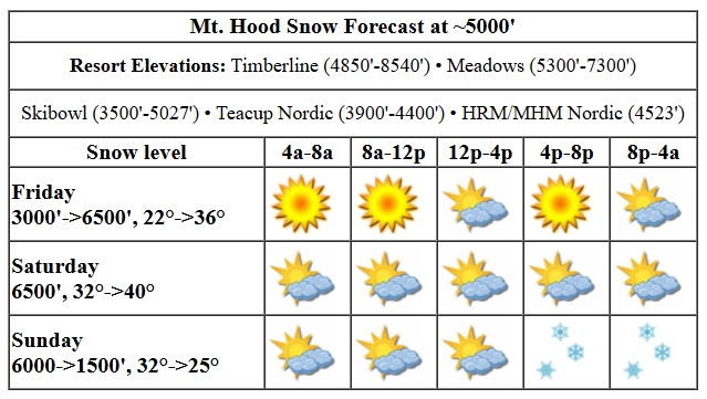
Friday’s Mt Hood weather starts sunny, adds some clouds midday, and turns clear again late. Those clouds should help the snow last longer and be less sticky than recently. The free air freezing level will be 3000′ in the morning. It rises to 6500′ by this evening. Temps start the day in the low 20s and rise to the mid 30s. Wind will be NW 15 early, WSW 10-15 in the afternoon, and WSW 20-25 after midnight.
Saturday brings filtered sun and plain-old-sun as high clouds move in and out. The free air freezing level will be around 6500′ all day. Temps rise to 40F in the afternoon. Wind: WSW 20-25 in the morning, SW 15-20 in the afternoon, and SW 20-30 overnight.
High clouds Sunday morning give way a period of clear sky then increasing clouds. Snow arrives in the evening. The snow level will be 6000′ in the morning, 4000′ in the afternoon, and 1500′ overnight. About 0.2” to 0.3” water equivalent (WE) is forecast for 2-3” new snow. Wind: SW 20-30 in the morning, SW 25-40 in the afternoon, and NW 20-25 after midnight.
extended mt hood weather forecast
Monday morning flurries give way to sun. Dry weather sticks around through Tuesday afternoon. Models give us a couple inches of snow Tuesday night. On and off light to moderate snowfall with low snow levels continues into Friday or Saturday. While there don’t seem to be any guaranteed huge powder days coming up, there does seem to be enough snow in the forecast to turn the groom and parks back to packed powder. Sounds fun. See you out there!
Was that helpful? I knew it was! Guess what? All of this crucial work – from your personal wind and snow reports to the invaluable TATAS updates – is made possible by my relentless efforts. Maintaining this labor of love isn’t easy. Each daily forecast takes hours. Website hosting, weather model access, and back-end admin work takes time and money. That’s where you come in.
YOUR CONTRIBUTION MAKES A DIFFERENCE
- SUPPORT ACCURATE, HYPER-LOCAL WEATHER FORECASTING
- ENABLE ACCESS FOR ALL, EVEN THOSE WITH LESS MEANS
- SUPPORT A COOL HUMAN WHO WORKS HARD SO YOU CAN PLAY
Take a moment to click one of the buttons below. Donate $19.99 or more (how much does this forecast enhance your life?) and get the email in your inbox. Whether it’s a renewing subscription (auto-renew) or a one-time donation, every contribution makes a real difference. Help me keep this labor of love alive, so we can all continue playing, commuting, and living in the Gorge with peace of mind and the best weather forecasts possible. Thank you!


Hood River, Oregon 97031


GORGE WIND FORECAST

Hi friends! Looks like a fun day was had on the river yesterday while I was working. Light westerlies are on tap today followed by nearly-calm wind Saturday and a chance at westerlies late in the day on Sunday. Generally speaking, the weather turns more active next week. That gives us at least some chance for gusty, frontally driven westerlies. Friday kicks off with pressures of 30.20/30.12/30.11 and westerlies in the 5-10mph range. Models say we’ll have 13-16ish all the way from Stevenson to Arlington this morning. Given the early pressure reading, a period of 17-20 seems possible from Viento to Swell or perhaps Hood River before the wind drops. And drop it shall! The wind fades in the afternoon and turns calm after 4pm. River flow over the last 24 hours was 114-172kcfs, river temp is 41.18F, and high temp forecast is 56F.
Saturday will be calm in the morning with westerlies at less than 10mph in the afternoon. High temp: 62F with high clouds. Depending on the timing of an approaching front on Sunday, we may or may not have westerlies prior to dark. As of right now, it looks like most of the day will be calm. Westerlies just might rise to 17-20 or so from Stevenson to Swell (or Hood River) and also near Rufus late in the day. They’ll pick up more overnight and fade again by dawn Monday. High temp: 62F with high clouds followed by increasing afternoon clouds. Not much happens for the first half of next week. Ensembles hint at next Thursday as the next best chance after Sunday. Have a fun day out there today!
BARE BONES HOOD RIVER WEATHER FORECAST
Clear sky this morning. Temps start in the mid 30s and rise to the mid 50s. Moderate westerlies. No rainbows. Saturday will be partly high cloudy. Temps start in the mid 30s and rise to the low 60s. Calm wind early. Light westerlies later. No rainbows. Sunday will have high clouds all day with increasing clouds late afternoon and rain in the evening. Temps start in the upper 30s and rise to the low 60s. Light and variable wind until late afternoon. Then moderate westerlies. No rainbows.
TEMIRA’S AWESOME TRAVEL ADVISORY SERVICE
HYPERLOCAL WEATHER FORECAST FOR THE COLUMBIA GORGE
THE DALLES, HOOD RIVER, WHITE SALMON, TROUT LAKE, STEVENSON, CASCADE LOCKS, PARKDALE, ODELL, HUSUM, BZ, MILL A, WILLARD, GOLDENDALE, RUFUS, ARLINGTON, boardman

Good morning, neighbors! It’s another damned fine day out there. Make the most of it – we only have a couple more of these damned fine days before we plunge right back into colder, wetter weather with a chance of a little snow down to river level.
glenwood and the tatas eootd
Let’s do our morning check-in with Glenwood: It’s 21 degrees there this morning with clear sky and dewpoint of 17 degrees. TATAS Executive Order Of The Day: It’s imperative that the federal government fund scientific studies and also agencies that practice science (like NOAA). You know, because we just can’t trust corporations to be unbiased when they fund things. This is hereby deemed to be a government mandate. Thus shall they be funded! Signed with a blue sharpie. Speaking of science, there are “Stand up for Science” rallies all across the country today. Not sure if there’s one here. But there’s one here tomorrow for International Women’s Day. Noon at the bottom of the Second Street Stairs in Hood River.
today’s gorge weather forecast
Weather today: sunny early except in the far west, where it’s cloudy. Clouds increase midday, and high clouds stick around tonight. Temps max out in the mid 50s in the lowlands. West wind will be 15ish mph from Stevenson to Hood River and 10-15mph to the east this morning. Late in the afternoon, the wind goes calm.
saturday & sunday
Saturday: glorious, despite the presence of some thin high clouds. After a mid-30s start in the lowlands (frosty up higher), temps rise into the low 60s. OMG, I hear my garden calling! Wind will be under 10mph all day. Sunday’s the last of the warmth for a bit. With high clouds in the forecast, temps should be above freezing most places. Clouds deepen during the day west of Hood River (ish) with high clouds to the east. In the evening, light rain moves in as far east as Rowena, and perhaps to The Dalles and SW after midnight. Total rainfall will be under 0.25” even in the wettest areas. Despite all these clouds, temps will peak in the low 60s. Wind: light most of the day with westerlies at 15-25mph from Stevenson to Hood River and perhaps east of the Dalles in the afternoon and night.
extended forecast
Cooler weather is in the cards for next week with intermittent light to moderate precipitation. We’ll dive more into the details as we get closer. Generally speaking, it looks like we’ll have neutral wind or light westerlies, which should keep the snow level off the deck (the deck being the Nch’i Wana). But we can’t rule out some intermittent light snowfall down to the river on some of the colder nights. There’s no sign of a bitterly cold snap – this is just Alaska sending cold air this way. Guess we’d better get all that gardening stuff and nude tanning at Iwash done now, eh? Safe travels. -TATAS
HEY! DON’T STOP READING! Is this community-focused forecast helpful to you? It sure is! It takes me a couple hours a day to write. Please join your friends and neighbors in contributing to keep it going. Venmo: @thegorgeismygym PayPal: twomirrors@gmail.com USPS: Temira / PO Box 841 / Hood River, Oregon 97031 You can test out the forecast subscription for a few days for free by clicking this link: https://subscribepage.io/YhevGc
