

MT HOOD SNOW FORECAST

Hey skiers and snowboarders! Chaos continues on Mt. Hood… Timberline had to shut down due to wind yesterday, and Meadows was only able to run Mt. Hood Express and Buttercup. Timberline is going for it today, and Meadows has all sorts of warnings about lift ops and snow quality on the website. Due to the saturated snowpack (it’s been raining below 6000′), Teacup is not grooming today.
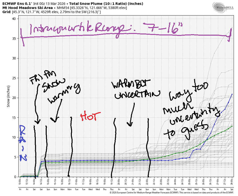
Short term Mt Hood snow forecast
Weather today: after a brief bout of lesser rain, the downpour returns. The snow level will be around 6500′ early and 6000′ in the evening. Around 2am, the snow level crashes to 1000′ or less, but most of the precip will be done by then. Prior to the drop in temps, we’ll see 1.1” rain (daytime) followed by 2.2” water equivalent (WE) mostly as rain overnight. If we get lucky, we’ll pick up 3-6” at the tail end of this system at 5000′. Above 6500′ today: lots and lots of snow. Wind will be problematic: W 55 all day long briefly dropping to W 45 overnight before rising to W 50 around sunrise Saturday.
Saturday morning starts mostly clear with some orographic clouds/flurries. The snow level will be (briefly) as low as 500′ before rising to 1500′ in the afternoon. Overnight, the free air freezing level drops to 1000′ under clear sky as temps at 5000′ hover right around 32F. It’s possible we could see up to an inch of snow during the day Saturday, but that would be the high end of possible. Wind: W 50 prior to dawn, NW 40 (shutdown) around 8am, NW 25-30 the rest of the day, and variable to 10 overnight. Delayed opening of lifts due to wind is likely as is the necessity for some deicing operations.
Extended Mt Hood Snow Forecast
Sunday will be high overcast with the potential for a short period of light drizzle in the evening. The snow level will be 0′ (isothermal at 32F) early, 7000′ in the afternoon, and 11,000′ overnight. Just a trace of rain is possible overnight. Wind will be variable to 10 in the morning, W 20 in the afternoon, and W 40 overnight.
Monday looks windy and cloudy in the morning and less windy with clear sky later. The free air freezing level will be higher than 10,000′ with temps rising to near 50F at 5000′. Wind will be W 40 (fine for most lifts) in the morning, SW 20-35 in the afternoon, and W 50 (problematic) overnight.
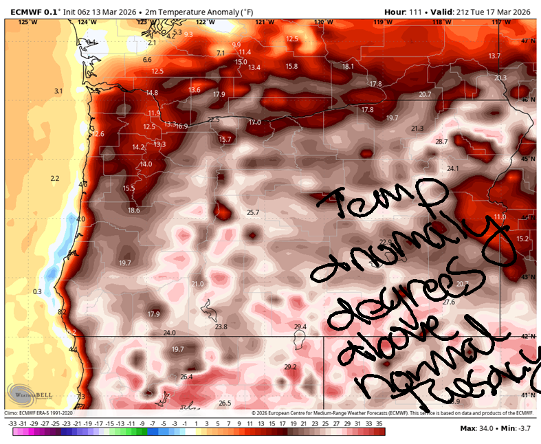
Tuesday and Wednesday look quite warm as an atmospheric river aims at BC and a hot (99th percentile) ridge builds over the western US. This one will send temps soaring towards 90 in the Bay Area and 100 for the desert southwest. For us, we’re looking at 50+ degrees on the slopes and 70F in the lowlands. Beyond that, uncertainty rises. Cooler weather returns sometime late next week or early the following week, but models are not optimistic about it being cold enough for snowfall on Mt. Hood. The intraquartile range through March 28 is 7-16”. Better get out there and enjoy what we’ve got!
Was that helpful? I knew it was! Guess what? All of this crucial work – from your personal wind and snow reports to the invaluable TATAS updates – is made possible by my relentless efforts. Maintaining this labor of love isn’t easy. Each daily forecast takes hours. Website hosting, weather model access, and back-end admin work takes time and money. That’s where you come in.
YOUR CONTRIBUTION MAKES A DIFFERENCE
- SUPPORT ACCURATE, HYPER-LOCAL WEATHER FORECASTING
- ENABLE ACCESS FOR ALL, EVEN THOSE WITH LESS MEANS
- SUPPORT A COOL HUMAN WHO WORKS HARD SO YOU CAN PLAY
Take a moment to click one of the buttons below. Donate $19.99 or more (how much does this forecast enhance your life?) and get the email in your inbox. Whether it’s a renewing subscription (auto-renew) or a one-time donation, every contribution makes a real difference. Help me keep this labor of love alive, so we can all continue playing, commuting, and living in the Gorge with peace of mind and the best weather forecasts possible. Thank you!


Hood River, Oregon 97031


GORGE WIND FORECAST
If you’re still seeing yesterday’s and it’s after 9am, try opening this in an incognito window
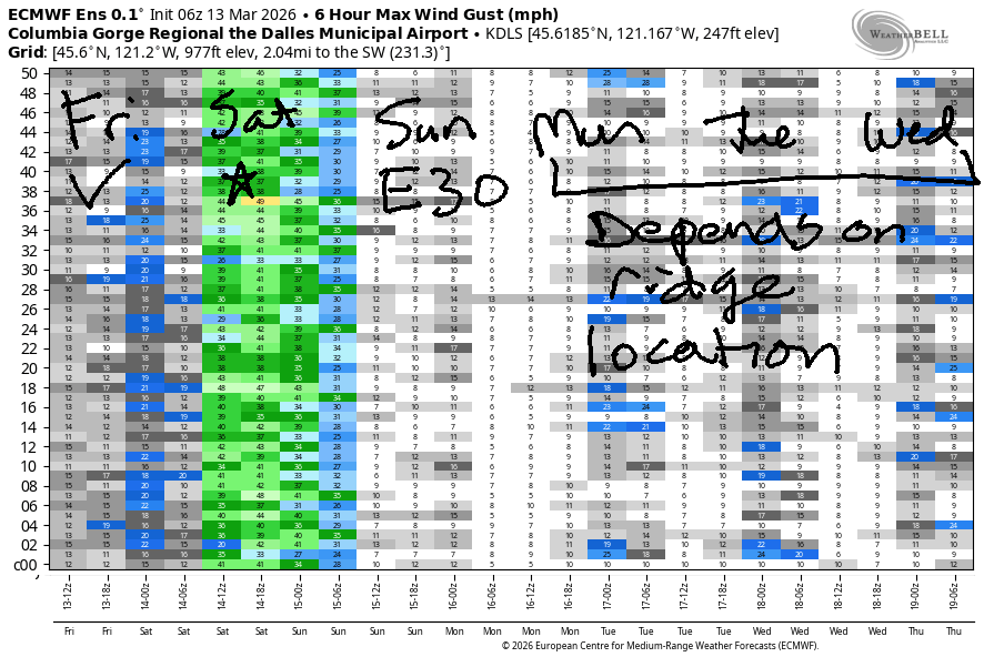
SHORT-TERM gorge wind forecast
Hi friends! We have some opportunities for you to get some river time in the next couple of days. Do be careful out there if you go – feeder rivers are running high, and there’s going to be a lot of debris in the Nch’i Wana (Columbia). We’ll have west wind (and heavy rain) today. On Saturday, strong westerlies are forecast. Ridging builds in on Sunday and brings a round of moderate easterlies. The location of that ridge over the rest of next week will determine what direction of wind we get; whether it’s easterlies or westerlies or nothing at all, it’s going to be nearly 70 degrees!
Looking at Friday, we started with pressures of 30.10/29.97/30.03 for gradients of 0.13 and E 0.05. Viento was reading 30mph when I got up, and the Hatch has been bouncing around in the 20-30mph range. Models suggest the Hatch will continue with very gusty 20-30mph wind all day. Expect pouring rain after 11am or so. Not much happens between Hood River and The Dalles – less than 10-15mph all day. At Rufus, you’re likely to find gusty 20-25mph, potentially slightly stronger, from mid-morning on. That wind, much like the wind at the Hatch, may respond negatively to incoming heavy rain from mid-morning on. River flow over the last 24 hours was 176-206kcfs (187-203 at Rufus). River temp is 45F, and high temp forecast is 56F in Hood River, 61F in the The Dalles, and 54F way out east.
RIVER FLOW FOR SITES BETWEEN AVERY (EAST OF THE DALLES) AND RUFUS: CLICK HERE FOR JOHN DAY DAM FLOW.
RIVER FLOW FOR SITES BETWEEN STEVENSON AND DOUG’S BEACH (WEST OF THE DALLES): CLICK HERE FOR THE DALLES DAM FLOW

LONGER-TERM gorge wind forecast
High pressure builds offshore overnight and sends the Viento-Mosier zone into the “nuking” range. Expect 30+ prior to dawn on Saturday. As high pressure pushes inland, we could see the Hatch drop some – models suggest it’ll drop to 17-20mph, but I wouldn’t be surprised if it beats the models by quite a bit, at least until mid-afternoon when high pressure may push far enough inland to knock areas west of Mosier down to the 14-17mph range. Looking out east… we’ve got 30-33mph (potentially a bit more!) from Lyle to Arlington, slowly fading into the afternoon. All locations drop precipitously after 5pm. All that said, a small shift in the timing could keep blasting westerlies going everywhere all day. This looks like a good one! High temp: 48F in Hood River, 50F out east with sunny sky everywhere.
Sunday sees the wind turn easterly in response to 1) cold overnight temps in the desert and 2) warmth moving in to the Valley of Willies (Willamette Valley) from the south. This gives us easterlies at 30-35mph at Iwash (Rooster) Rock and 20-25mph at Stevenson. High temp: 50F.
Beyond Sunday, we’re waiting to see exactly where the ridge of high pressure locates itself. Light westerlies seem possible, but I’m going to hold off on any solid predictions. Be careful out there – stay on the lookout for debris, and keep an eye on your buddies.

BARE BONES HOOD RIVER WEATHER FORECAST
Clouds all day with increasing rain after 11am. Temps start in the low 50s and rise to the mid 50s. Moderate westerlies. 4% chance of rainbows. Saturday will be sunny. Temps start in the mid 30s and rise to the upper 40s. Strong westerlies. 0.5% chance of rainbows. Sunday will be cloudy. Temps start in the mid 30s and rise to 50 or so. Light easterlies. No rainbows.
TEMIRA’S AWESOME TRAVEL ADVISORY SERVICE
HYPERLOCAL WEATHER FORECAST FOR THE COLUMBIA GORGE
THE DALLES, HOOD RIVER, WHITE SALMON, TROUT LAKE, STEVENSON, CASCADE LOCKS, PARKDALE, ODELL, HUSUM, BZ, MILL A, WILLARD, GOLDENDALE, RUFUS, ARLINGTON, boardman
Good morning, neighbors! This morning, l as I write this, we’re in a short break from the downpour. It’ll be back late morning, and it’ll stick around into the night. Expect a downpour from 11am into the wee hours o Saturday for your city-country commute. Dry (or mostly dry) weather arrives early Saturday and sticks around (probably) for a while. Highlight of next week: nearly 70 degrees Monday through Wednesday.
Glenwood this morning
Friday started off warm, potentially record warm, but HRW and I have to discuss this. Glenwood was 48F this morning, warm enough for folks to milk the cows in a banana hammock. There’s no ice or snow on the roads this morning, and there’s no !CE as best we can see. Road conditions may change tonight…
Today’s Gorge weather forecast
After a rainy, rainy day all the way east to Idaho, we’ll see colder air arrive tonight. Those of you above 1000′ could see a few snowflakes after midnight, but accumulation in our inhabited zones is unlikely. Temps on Friday max out in the mid 50s (west and desert) to low 60s (The Dalles). Wind will be 20-30mph west of Hood River, 10mph from Hood River to Lyle, and 20-25mph from Avery to Rufus.
Saturday’s Gorge weather forecast
As I said, colder air arrives after midnight and may result in a few snowflakes above 1000′. Saturday morning lowland temps will be in the mid 30s. Sub-freezing temps are possible above 500-1000′, but strong west wind will minimize cooling. Icy windshields are more likely than icy roads as road temps are pretty warm. Still… do be careful out there Saturday morning just in case. For the rest of the day: clear sky, 50ish degrees, and strong west wind all the way from Stevenson to Hermiston, strongest near Biggs.
Sunday’s Gorge weather forecast
If clear sky sticks around long enough Saturday night, we could see some sub-freezing temps on Sunday morning. Except a cloudy Sunday with high temps near 50. West wind: no. East wind: yes – 30mph near Iwash (pen*s) Rock and Stevenson.
Starting Monday, warming takes over. High temps will be 60-70F (so much uncertainty in the models) Monday trough (definitely) Wednesday and potentially longer. As of this morning, we’re not expecting strong wind along with the warmth; this looks like perfect weather to get outside. Beyond the middle of next week, uncertainty rises, but nothing out of the ordinary is forecast other than unseasonably dry/warm weather… We broke the planet. I don’t think there’s an award for that. Safe travels. -TATAS
HEY! DON’T STOP READING! Is this community-focused forecast helpful to you? It sure is! It takes me a couple hours a day to write. Please join your friends and neighbors in contributing to keep it going. Venmo: @thegorgeismygym PayPal: twomirrors@gmail.com USPS: Temira / PO Box 841 / Hood River, Oregon 97031 You can test out the forecast subscription for a few days for free by signing up below. Easy! Do it!
JONES BEACH, SAUVIE ISLAND, & COAST FORECAST
ON WINTER VACATION UNLESS DESPERATELY NEEDED.

Leave a Reply