

MT HOOD SNOW FORECAST

Hey skiers and snowboarders! A dry and warm weekend on Mt. Hood gives way to another round of very active weather next week. Both the GFS and Euro have a period of heavy snowfall Tuesday night into Wednesday. That’s good news, for sure!
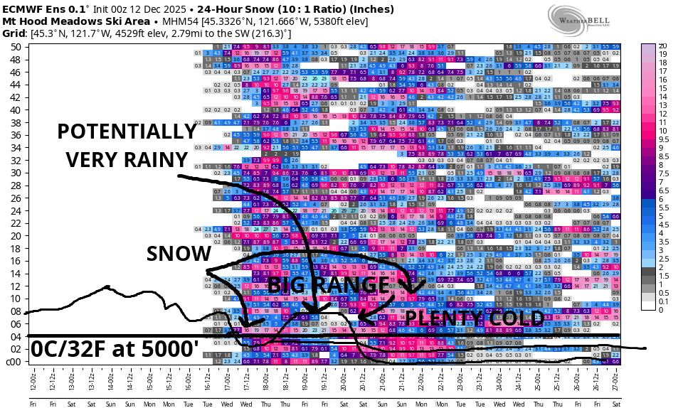
For the Thursday pm to Saturday morning period, there’s vast uncertainty in the models as yet another atmospheric river takes aim at the West Coast. Our good friend the GFS keeps us on the cold side of this system – all of its ensemble members are on board with this. On the bummer side of things, the Euro has about an 80%-90% chance of Mt Hood being on the warm side of this system; it’s calling for another round of multi-inch rainfall. Better news returns around the 20th, when both the Euro and the GFS drive temps at 5000′ below 32F/0C and keep them there for the extended period.
Let’s look at the easy parts of the forecast first. Friday and Saturday look warm and sunny on Mt. Hood. The free air freezing level will be well above 10,000′ for this time period. Wind Friday starts at W 10mph, rises to W 20-30mph, and drops to W 20mph overnight. Saturday’s wind starts at W 20mph, drops to SW 10mph in the afternoon, and rises to WSW 30mph overnight.
Clouds thicken throughout Sunday. The free air freezing level starts well above 10,000′ and eventually falls to 9000′ after midnight. Wind: WSW 30 in the morning, SW 20-35 in the afternoon, and SW 20-30 after midnight.
On Monday, we’re expecting steady and potentially heavy rain. As of this morning, the GFS sounding model has the snow level around 8000′ to 9000′ all day and down to 7000′ after midnight. In that time period, 2.5” to 3.0” rain is forecast. Wind: SW 20-30 in the morning rising to SW 40-55 in the evening and WSW 40-45 after midnight.
Tuesday starts with rain and eventually switches to snow late in the evening. Most of the moisture will fall during the day (a couple inches, perhaps) before the switch to snow. Overnight, given strong orographic (terrain-enhanced) support, we could see half a foot of snow.
Looking at the Wednesday through early Thursday time period, our friendly models give us at least 1.0” water equivalent as snow – that’s at least a foot of snow on top of what falls at the end of the Tuesday system. Uncertainty skyrockets late next week as the GFS and ECMWF disagree on the aim of the next system. We could pick up significant snowfall. We could also pick up massive rainfall. There’s way too much uncertainty to make plans yet; we’ll certainly be keeping a very close eye on this together! Fingers crossed. I’m sure ready to get my skis underneath me, and I’m guessing you feel the same way about your skis or snowboard. Hope to see you on the slopes soon!
Was that helpful? I knew it was! Guess what? All of this crucial work – from your personal wind and snow reports to the invaluable TATAS updates – is made possible by my relentless efforts. Maintaining this labor of love isn’t easy. Each daily forecast takes hours. Website hosting, weather model access, and back-end admin work takes time and money. That’s where you come in.
YOUR CONTRIBUTION MAKES A DIFFERENCE
- SUPPORT ACCURATE, HYPER-LOCAL WEATHER FORECASTING
- ENABLE ACCESS FOR ALL, EVEN THOSE WITH LESS MEANS
- SUPPORT A COOL HUMAN WHO WORKS HARD SO YOU CAN PLAY
Take a moment to click one of the buttons below. Donate $19.99 or more (how much does this forecast enhance your life?) and get the email in your inbox. Whether it’s a renewing subscription (auto-renew) or a one-time donation, every contribution makes a real difference. Help me keep this labor of love alive, so we can all continue playing, commuting, and living in the Gorge with peace of mind and the best weather forecasts possible. Thank you!


Hood River, Oregon 97031


GORGE WIND FORECAST
If you’re still seeing yesterday’s and it’s after 9am, try opening this in an incognito window
today’s gorge wind forecast
Hi friends! Not much happening for the next three days. At best, we might see some light easterlies on Saturday. Looking at next week, there’s a shot at westerlies in the Monday through Wednesday, maybe Thursday too, time period, but it’s all going to be frontally-driven and timing dependent.
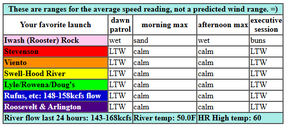
Looking at Friday morning, we have lingering west gradients – 30.21/30.18/30.15 – but not much wind out there. Models have the wind turning calm most of the day and then swinging light westerly, 10mph or less, after 1pm. River flow over the last 24 hours was 143-168kcfs, river temp is 50.0F, and high temp forecast is 60F with plenty of sun.
RIVER FLOW FOR SITES BETWEEN AVERY (EAST OF THE DALLES) AND RUFUS: CLICK HERE FOR JOHN DAY DAM FLOW.
RIVER FLOW FOR SITES BETWEEN STEVENSON AND DOUG’S BEACH (WEST OF THE DALLES): CLICK HERE FOR THE DALLES DAM FLOW

Weekend gorge wind forecast
Saturday brings easterlies at 15, maybe 15-20mph, all day at Stevenson. Iwash (Rooster) Rock starts at 15mph and turns light/variable in the afternoon. High temp: 57F and mostly sunny. Sunday looks light westerly, under 10mph, in the morning and calm in the afternoon. High temp: 55F and cloudy.
extended Gorge wind forecast
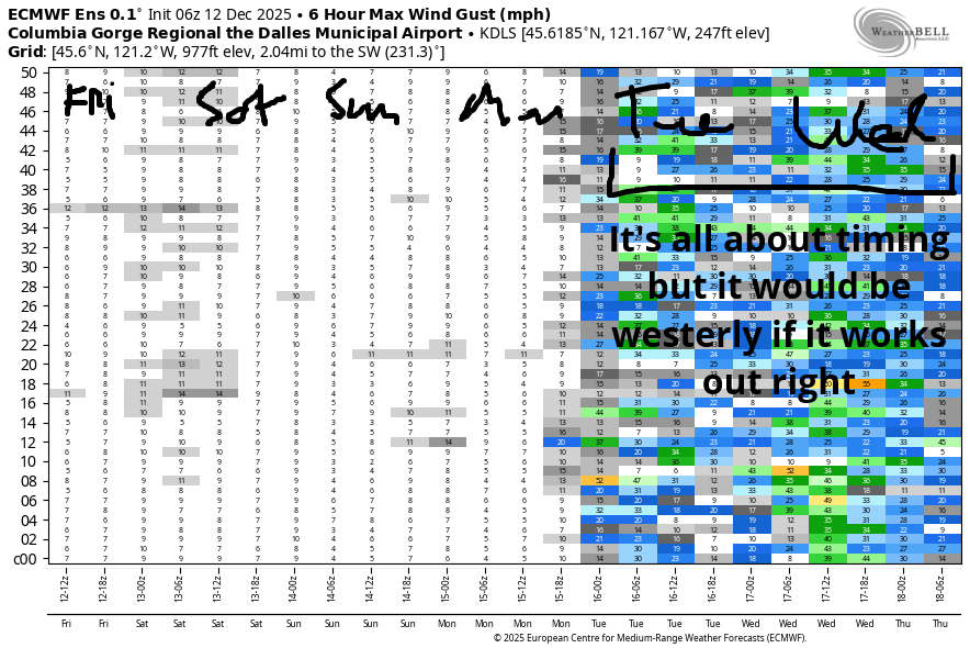
Active weather returns next week as an atmospheric river takes aim (again) at the Pacific Northwest. As impulses push through, we could see associated surface wind, but it’s going to be timing-dependent; we don’t have much daylight now to work with. Fingers crossed!
BARE BONES HOOD RIVER WEATHER FORECAST
Cloudy this morning and mostly clear this afternoon. Temps start in the mid 40s and rise to 60 or so. Calm wind becoming light westerly. No rainbows. Saturday will be partly Nothing then clear then partly high cloudy. Temps start in the low 40s and rise to the upper 50s. Light easterlies. No rainbows. Sunday will be cloudy. Temps start in the low 40s and rise to the mid 50s. Light westerlies. No rainbows.
TEMIRA’S AWESOME TRAVEL ADVISORY SERVICE
HYPERLOCAL WEATHER FORECAST FOR THE COLUMBIA GORGE
THE DALLES, HOOD RIVER, WHITE SALMON, TROUT LAKE, STEVENSON, CASCADE LOCKS, PARKDALE, ODELL, HUSUM, BZ, MILL A, WILLARD, GOLDENDALE, RUFUS, ARLINGTON, boardman
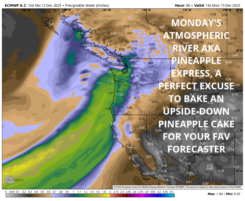
Good morning, neighbors! I woke up ridiculously early this morning for no particular reason, so here we are with an early forecast. On tap: definitely not any sort of tap into the Pineapple Express this weekend. Instead, we’re set for three days of dry weather Friday through Sunday. Rain returns on Monday and sticks around for a good portion of next week. Once again, we’ll be linking up with the Pineapple Express for part of the week. Up on the mountain passes: significant snowfall on Wednesday into Thursday and potentially beyond, so do plan your travels accordingly!
Glenwood this morning
Looking around the Gorge this morning, it’s another unseasonably warm start. Glenwood was 44F this morning. Everyone was shaking their heads at the vastness of the stacks of firewood which aren’t diminishing at their usual rates. Creatures living in those stacks – rats, mice, and the occasional Sasquatch – were happy at not having their homes disturbed (ala Mrs. Frisby And The Rats of NIMH). Elsewhere in the Gorge, roads appeared to be free of ¡CE this morning, but it’s still early and folks are still watching.
Today’s Gorge weather forecast
It’ll be a beautiful day today for cruising around and marveling at the beauty of our home. The west side starts cloudy, and the east side starts with a few high clouds. By afternoon, we’ll all be mostly clear and… wait for it… 60 DEGREES! Today’s record high in Hood River (where I have easiest access to records) is 60F, so it might just fall. We did set a new record high yesterday with 59F. Today’s wind: light westerly or calm depending on where you’re located.
Saturday’s Gorge weather forecast
Overnight, we’ll have mostly clear sky. Great for that all time combo of stargazing and masturb*ting! This (the clear sky, not your self-s*x) results in a partial Nothing Saturday, but it’ll burn off fast and leave us with sunshine. High clouds move in late. WHAT A GLORIOUS DAY TO BE OUTSIDE! Sadly, I’m in a Zoom training almost all day. You go outside for me! Temps start in the low 40s and rise to the upper 50s. Add in light east wind (15-20mph max at Stevenson and Iwash), and you have a ridiculously lovely day for the middle of December.
Extended Gorge weather forecast
Sunday will be filled with clouds, but it’ll still be dry with light wind. After a low-40s start, everyone in the lowlands maxes out in the mid 50s. Rain returns on Monday as another Pineapple Express (an atmospheric river with a tropical tap) makes contact. This continues into Tuesday. A kinda-break in the weather is possible on Wednesday before we’re maybe/maybe not impacted by another Pineapple Express later in the week. Or maybe that one will stay too far south to drench us. Depends on which model you ask.
As I mentioned earlier, there will be a period of heavy snowfall on the passes late Tuesday night into Wednesday (maybe beyond, maybe not), so be prepared for winter driving conditions above 2500′ or so. We’ll look more closely at that in coming days. Other travel impacts will be heavy rain in the western Gorge related to these atmospheric rivers. We’ll explore the details as the time nears. In the meantime… Safe travels. -TATAS
HEY! DON’T STOP READING! Is this community-focused forecast helpful to you? It sure is! It takes me a couple hours a day to write. Please join your friends and neighbors in contributing to keep it going. Venmo: @thegorgeismygym PayPal: twomirrors@gmail.com USPS: Temira / PO Box 841 / Hood River, Oregon 97031 You can test out the forecast subscription for a few days for free by signing up below. Easy! Do it!
JONES BEACH, SAUVIE ISLAND, & COAST FORECAST
ON WINTER VACATION UNLESS DESPERATELY NEEDED.
