

MT HOOD SNOW FORECAST

Hey skiers and snowboarders! It’s Friday morning, and it’s a packed pow day on Mt. Hood. Get it as early as you can, because the sun will warm the snow quickly and turn it sticky. The snow surface will be transitioning towards granular over the weekend thanks to 50+ degree highs on the slopes. We’re back to colder weather Tuesday (ish), but at best, a trace of snow is forecast. Not much precip is in the forecast through next week. As a matter of fact, the intraquartile range through the 18th of April is just 2-8” snowfall.
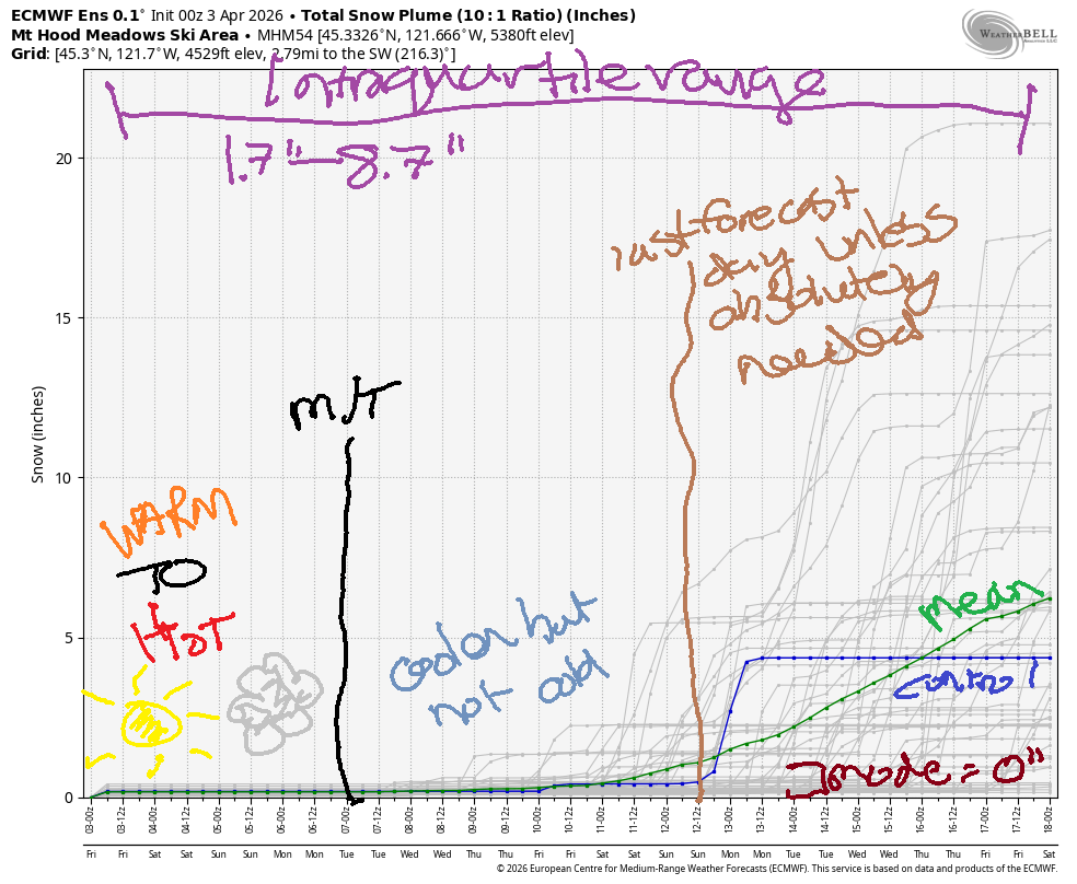
Short term Mt Hood snow forecast
Friday starts with a few high clouds (pretty sunrise incoming!) and stays mostly clear. The free air freezing level will be 4000′ early, 6500′ in the afternoon, and 7500′ after midnight. Temps at 5000′ rise to the mid 40s today. Don’t forget your sunscreen and warm wax! Wind will be light westerly all day, and then it’ll become light and variable overnight. Snow surface: packed powder early and sticky warming snow later.
Saturday starts clear and adds high clouds later. The free air freezing level rises from 7500′ in the morning to 10,000′ in the afternoon. At 5000′, temps rise to the low 50s. You better wax warm to account for that! Wind will be light and variable all day and S 10-20 overnight. Snow surface: hardpack in the morning and sticky transitioning snow in the afternoon.
Extended Mt Hood Snow Forecast
Sunday will be sunny and warm. The free air freezing level holds at 10,000′ or higher all day, and temps max out in the (gasp) mid 50s. Wind will be S 10-20 early, S 5-10 in the afternoon, and light westerly overnight. Given the clear sky and light wind, it’s likely the snow surface will freeze overnight leaving us with a hard/fast (briefly) start to the day. Maybe we’ll even see corn snow if Saturday’s heat transitions the snow fully to granular.
Monday also looks sunny and warm with increasing west wind. Snow surface: spring skiing. Cooler, potentially quite windy weather is in the cards Tuesday as a (mostly dry) cold front arrives from the NW. Beyond that: cooler conditions, but very little chance of snow. As I keep saying… get it while you can! Hope to see you on the snow soon!
Was that helpful? I knew it was! Guess what? All of this crucial work – from your personal wind and snow reports to the invaluable TATAS updates – is made possible by my relentless efforts. Maintaining this labor of love isn’t easy. Each daily forecast takes hours. Website hosting, weather model access, and back-end admin work takes time and money. That’s where you come in.
YOUR CONTRIBUTION MAKES A DIFFERENCE
- SUPPORT ACCURATE, HYPER-LOCAL WEATHER FORECASTING
- ENABLE ACCESS FOR ALL, EVEN THOSE WITH LESS MEANS
- SUPPORT A COOL HUMAN WHO WORKS HARD SO YOU CAN PLAY
Take a moment to click one of the buttons below. Donate $19.99 or more (how much does this forecast enhance your life?) and get the email in your inbox. Whether it’s a renewing subscription (auto-renew) or a one-time donation, every contribution makes a real difference. Help me keep this labor of love alive, so we can all continue playing, commuting, and living in the Gorge with peace of mind and the best weather forecasts possible. Thank you!


Hood River, Oregon 97031


GORGE WIND FORECAST
If you’re still seeing yesterday’s and it’s after 9am, try opening this in an incognito window
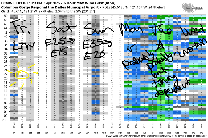
SHORT-TERM gorge wind forecast
Hi friends! Hopefully each and every one of you found some fun on the river on Thursday. Not much happens over the next couple of days – light westerlies today (Friday), moderate easterlies for the weekend, and westerlies of some sort Monday and Tuesday. It’s possible we could see a period of strong west wind Tuesday, but it’ll be timing-dependent.
Friday kicks off with pressures of 30.40/30.36/30.33 and light west wind. The wind turns dead calm midday and picks up to W 7-10mph from Stevenson to Hood River or Mosier late afternoon. River flow over the last 24 hours was 188-236kcfs, river temp is 47.1F, and high temp forecast is 63F and mostly sunny.
Saturday starts with E 25mph at Iwash/Rooster and 15-20mph at Stevenson. Both locations peak at 25mph mid-morning before slowly fading to 15mph late afternoon. High temp: 69F with increasing high clouds in the afternoon after a sunny start.
RIVER FLOW FOR SITES BETWEEN AVERY (EAST OF THE DALLES) AND RUFUS: CLICK HERE FOR JOHN DAY DAM FLOW.
RIVER FLOW FOR SITES BETWEEN STEVENSON AND DOUG’S BEACH (WEST OF THE DALLES): CLICK HERE FOR THE DALLES DAM FLOW

LONGER-TERM gorge wind forecast
Sunday looks slightly windier to start: 35mph at Iwash Rock and 25mph at Stevenson. By late morning, the fade starts. Evening wind lands at 15-20mph at Iwash and 15mph at Stevenson, which will really mess up your naked-tanning plans at Iwash Rock. High temp: 71F with high clouds.
Depending on the timing of the Monday-Tuesday system, we could see strong-enough westerlies (17-20mph or more) on Monday. A massive high temp drop, at least 10 degrees but possibly 20 degrees, is forecast between Monday and Tuesday thanks to an incoming cold front from the NW. We should see moderately strong to strong westerlies at some point as this happens, but the timing and details are far from clear. Have fun out there on the Nch’i Wana!

BARE BONES HOOD RIVER WEATHER FORECAST
Partly cloudy sky this morning. Mostly clear later. Temps start near 40 and rise to the low 60s. Light westerlies, then calm, then light westerlies. No rainbows. Saturday will be clear then high cloudy. Temps start in the upper 30s and rise to the upper 60s. Light easterlies. No rainbows. Sunday will be partly high cloudy. Temps start in the mid 40s and rise to the low 70s (WARM!!!). Light easterlies. No rainbows.
TEMIRA’S AWESOME TRAVEL ADVISORY SERVICE
HYPERLOCAL WEATHER FORECAST FOR THE COLUMBIA GORGE
THE DALLES, HOOD RIVER, WHITE SALMON, TROUT LAKE, STEVENSON, CASCADE LOCKS, PARKDALE, ODELL, HUSUM, BZ, MILL A, WILLARD, GOLDENDALE, RUFUS, ARLINGTON, boardman

Good morning, neighbors! Sadly, there’s no news to report this morning on additional motivational and/or musical signs on the Hood River Bridge, but at least it’s going to be a “gorge”-eous day. For the next few days, the weather falls into what TATAS describes as “PERFECT” temperatures. Those of you who prefer your weather not-windy (exception, areas west of Hood River) will like the next few days too!
Glenwood this morning and today’s Gorge weather forecast
Checking things out this Friday (TGIF!!!) morning, we see a low of 26F in Glenwood, where it’s… cold. Parkdale and Trout Lake lows were 30-33F, and similar temps were seen near The Dalles and Goldendale. Mosier and Centerville were a bit warmer this morning with mid 30s, and everyone else was above freezing. We’ll keep a few clouds today on the west side, but the forecast is crystal clear east of Rowena. High temps will be right around 63F all across the lowlands. We’ll have a respite from the wind today – max wind will be under 10mph, and many places will be dead calm all day. Dead calm, by the way, is not what I’m trying to achieve by partaking in this online meditation retreat. The goal is closer to “alive calm”.
Saturday’s Gorge weather forecast
Mostly clear sky tonight combines with light wind and dewpoints around 28-36F for a mild Saturday morning. Lows likely hold in the mid 30s or higher thanks to +8C temps at 5000′. High clouds increase during the day which sets us up for a beautiful sunset. I’m talking to you photographers! During the day, east wind will be 20-25mph near Stevenson and Iwash (pen*s) Rock. Elsewhere: light easterlies. Max temps rise to 69F (you know what to do!) to the west and in the desert with 71F in The Dalles, where everyone is flocking to Fred Meyer’s annual Fuchsia Saturday sale!
Sunday’s Gorge weather forecast
Sunday, thanks to high clouds, even warmer temps aloft (+13C!!!!!) and slightly more east wind, starts warmer: mid 40s. Afternoon temps rise to 71-74F. I know you want to go to the naked beach at Iwash Rock. Unfortunately, you’ll encounter east wind at 35mph in the morning and 15-20mph in the afternoon. Not a good day to tan naked. Same goes for Stevenson (there is no naked beach there, but it’s a GREAT place to exercise your constitutional rights), where the easterlies will be 25mph in the morning and 15mph in the afternoon. Elsewhere; light easterlies at most, and calm many places.
Extended Gorge weather forecast
On Monday, Ma Nature has a treat planned: 75 degrees and light west wind. The only thing TATAS likes more is 75 degrees and nuking west wind. High temps fall at least 10 degrees as we move into Tuesday. From then on into the rest of next week, highs will be around 60F. Rain chances are minimal all through next week. This results in zero additional snow water equivalent being added to the Mt. Hood snowpack which currently sits at the 4th percentile and 41% of normal SWE. Things do not look good for irrigation water this year. Fingers crossed for our farmers. Safe travels. -TATAS
HEY! DON’T STOP READING! Is this community-focused forecast helpful to you? It sure is! It takes me a couple hours a day to write. Please join your friends and neighbors in contributing to keep it going. Venmo: @thegorgeismygym PayPal: twomirrors@gmail.com USPS: Temira / PO Box 841 / Hood River, Oregon 97031 You can test out the forecast subscription for a few days for free by signing up below. Easy! Do it!
JONES BEACH, SAUVIE ISLAND, & COAST FORECAST
ON WINTER VACATION UNLESS DESPERATELY NEEDED.

Leave a Reply