

MT HOOD SNOW FORECAST

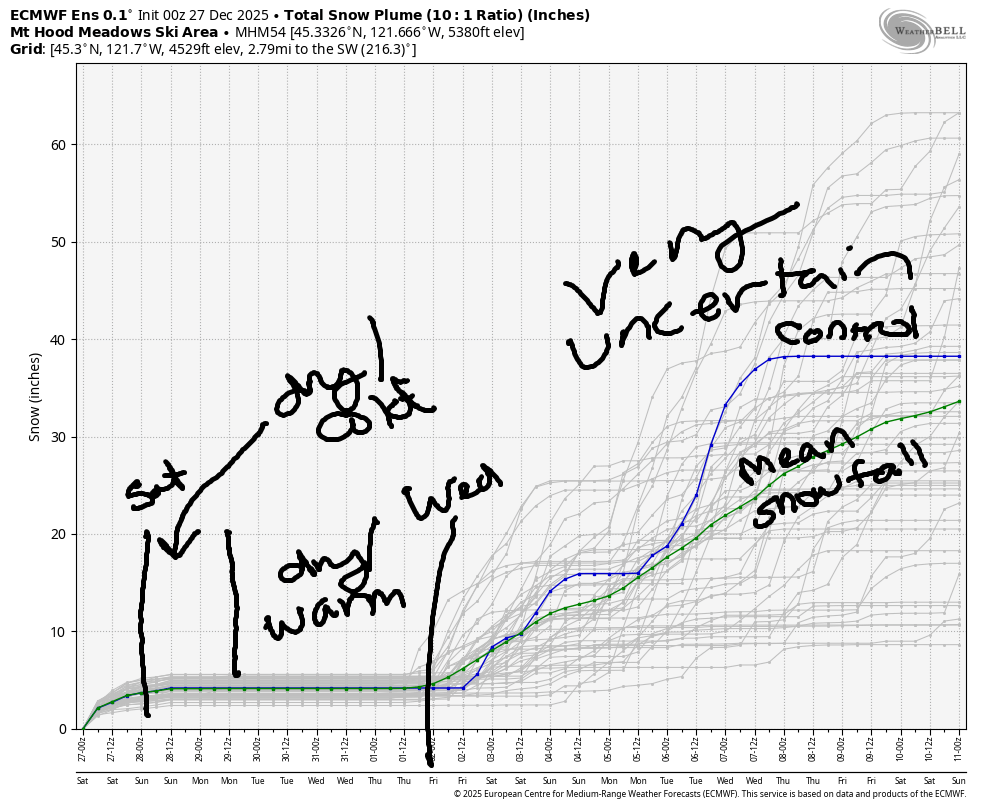
Hey skiers and snowboarders! Spring skiing returns to Mt. Hood through Tuesday as a rather summer-like synoptic-scale pattern settles over the Northwest. Next chance of snowfall comes next Wednesday with a system out of the NW.
That pattern looks to stick around for a few days. I sure hope it does – that particular setup is generally a very good one for Mt. Hood. Details, of course, are unclear this far out. Looking longer range… the intraquartile range through March 13th gives us 15.5” to 36.5” new snow for Mt. Hood.
Short term Mt Hood snow forecast
Before I forget… next weekend is Ski ALS at Meadows. One of my dear friends was recently diagnosed with ALS. He too is a skier. If you feel moved to contribute to my fundraising efforts for the ALS Northwest foundation, I’d really appreciation it! Even a few dollars is helpful!
No new snow is forecast on Friday. Nope. All we get is sunbeams. The free air freezing level will be 6500′ in the morning and 8000′ from this afternoon on into the night. Temps max out in the upper 30s at 5000′. Wind will be WNW 15-20 all day long. Overnight, it drops to NW 5-10mph.
Extended Mt Hood Snow Forecast
Saturday may start clear, but it’s likely to add some high clouds. The free air freezing level rises from 8000′ to 9500′ before falling back to 8500′ overnight. Temps max out in the low 40s at 5000′. Wind will be light and variable. On Sunday, a partly cloudy start gives way to sunshine. Freezing level: 8000′, give or take 500′. Temps rise to the low 40s, and the wind will be light and variable. Monday looks nearly identical.
On Tuesday, we start with sunshine and hold on to it into the afternoon. Overnight, a cold front arrives from the northwest and brings snow to the slopes. The freezing level starts around 8500′, but the snow level will fall to 4000′ with the arrival of this system. Just a few inches of snow are forecast by Wednesday morning, but more snow is in the cards for the latter half of next week. Given the overall pattern, it’s likely to be windy as well. Let’s all do the snow dance thing in support of these weather systems – come on cold and wet! See you on the snow!
Was that helpful? I knew it was! Guess what? All of this crucial work – from your personal wind and snow reports to the invaluable TATAS updates – is made possible by my relentless efforts. Maintaining this labor of love isn’t easy. Each daily forecast takes hours. Website hosting, weather model access, and back-end admin work takes time and money. That’s where you come in.
YOUR CONTRIBUTION MAKES A DIFFERENCE
- SUPPORT ACCURATE, HYPER-LOCAL WEATHER FORECASTING
- ENABLE ACCESS FOR ALL, EVEN THOSE WITH LESS MEANS
- SUPPORT A COOL HUMAN WHO WORKS HARD SO YOU CAN PLAY
Take a moment to click one of the buttons below. Donate $19.99 or more (how much does this forecast enhance your life?) and get the email in your inbox. Whether it’s a renewing subscription (auto-renew) or a one-time donation, every contribution makes a real difference. Help me keep this labor of love alive, so we can all continue playing, commuting, and living in the Gorge with peace of mind and the best weather forecasts possible. Thank you!


Hood River, Oregon 97031


GORGE WIND FORECAST
If you’re still seeing yesterday’s and it’s after 9am, try opening this in an incognito window
SHORT-TERM gorge wind forecast
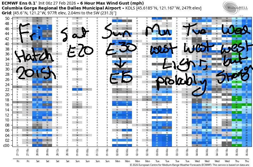
Hi friends! Our anomalous winter westerly streak continues today, and then we fall into a couple days of easterlies. Models suggest westerlies of some sort are possible next week, especially after Tuesday, when the flow switches to northwesterly.
Friday starts with pressures of 30.38/30.30/30.25 for gradients of 0.08/0.05. Despite the presence of eastern Gorge gradients this morning, models insist that the Hatch is the place to be today. We starts with 14-17 from Viento to Hood River. The wind should pick up to 19-22 for a couple hours before dropping back to 14-17 midday. In the afternoon, 18-21mph is likely form Stevenson to Hood River with 13-16mph from Mosier to The Dalles. Out east: not much today. River flow over the last 24 hours was 162-206kcfs, river temp is 41.5F, and high temp forecast is 55F with sunshine.
RIVER FLOW FOR SITES BETWEEN AVERY (EAST OF THE DALLES) AND RUFUS: CLICK HERE FOR JOHN DAY DAM FLOW.
RIVER FLOW FOR SITES BETWEEN STEVENSON AND DOUG’S BEACH (WEST OF THE DALLES): CLICK HERE FOR THE DALLES DAM FLOW

LONGER-TERM gorge wind forecast
Saturday switches direction: the day starts with light easterlies. Peak wind happens mid-morning with 20-25mph at Stevenson and 20mph at Iwash/Rooster. Afternoon wind drops to 10mph at Iwash and 15mph at Stevenson. High temp: 54F and cloudy. Sunday starts with 20mph at Iwash and drops to 20mph midday before finishing at 15mph. Stevenson starts with 20mph, holds most of the day, and ends the day with 15mph. High temp: 55F with clouds in the morning and sun later.
As we start next week, offshore high pressure locates itself in a spot conducive to light westerlies. As of this morning, it looks like the wind will stay below 15mph on Monday and Tuesday (which is good, because I wont’ be able to forecast those days!). On Wednesday, an approaching cold front from the NW gives us a shot at stronger westerlies; this particular setup is Rufus-conducive. We’ll keep an eye on it! Have fun out there. Stay warm, and keep an eye on each other!
BARE BONES HOOD RIVER WEATHER FORECAST
Sunshine all day. Temps start in the mid 30s and rise to the upper 50s. Moderate westerlies. No rainbows. Saturday will be cloudy. Temps start in the mid 30s and rise to the mid 50s. Light easterlies. No rainbows. Sunday will be mostly cloudy then mostly clear. Temps start in the upper 30s and rise to the mid 50s. Light easterlies. No rainbows.
TEMIRA’S AWESOME TRAVEL ADVISORY SERVICE
HYPERLOCAL WEATHER FORECAST FOR THE COLUMBIA GORGE
THE DALLES, HOOD RIVER, WHITE SALMON, TROUT LAKE, STEVENSON, CASCADE LOCKS, PARKDALE, ODELL, HUSUM, BZ, MILL A, WILLARD, GOLDENDALE, RUFUS, ARLINGTON, boardman
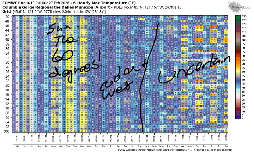
Good morning, neighbors! Another anomalously beautiful winter day is on tap – this one’s going to resemble a standard summer day (minus 20 degrees) more than it resembles February. I wish I could tell you “winter’s just around the corner”, but it’s not! All we have coming up is 50+ degrees for the next three days, a couple of beautiful days to start next week, some cooler weather midweek, and then a hint of another round of warmer temps to start the following week.
Glenwood this morning
There’s not all that much to say today, so I’m gonna try and keep it short (like my friend Carly – she’s short!). Glenwood is proud of itself this morning with 24F – pretty much everyone else is 32F (Parkdale) or warmer. West side Hood River is a balmy 42F this morning, the answer to Life, The Universe, And Everything. Everyone there is reading that book and chuckling. Everyone is also standing up and protesting the banning of books, which strangely enough, mostly seem to be books by or about BIPOC folks, LGBTQ+ folks, women, or people fomenting change…. so strange!
Today’s Gorge weather forecast
Your TGIF weather (this is my only day “off”, so I’m TG’ing the fuck outta it – gratitude for the win!) brings sunshine, west wind at 15-20mph west of The Dalles (light to the east), and temps pushing the mid 50s in the west and LOW 60s SO WARM from The Dalles eastward. “Normal” high for today is 50F.
Weekend Gorge weather forecast
Clouds arrive on Saturday, but they don’t bring any moisture. After a mid-30s start, we finish up in the mid 50s. Add in east wind at 20mph at Iwash (STOP PROTECTING THE PEDOS) Rock and Stevenson with light wind elsewhere. Nudge temps up to the mid 50s. And that’s your Saturday. Sunday looks identical except for the cloud cover: morning clouds give way to afternoon sunshine.
Extended Gorge weather forecast
I’ll be gone Monday and Tuesday, which is super-duper-sad, because here in the Gorge, we’re expecting 60 degrees, sunshine, and light west wind both days. (crying faces for me) A weather system slides in from the NW on Tuesday night, and cooler, damper weather is forecast for the next few days.
With the systems coming from the NW, the Cascade Rain Shadow System (it’s like a missile defense system, but way more peaceful and likely to help people) will be operating. Rain is likely to stay west of Mosier. If we end up with enough moisture (unlikely), we might also see rain between The Dalles and Rufus, but that’s probably not going to happen. Nor is lowland snow. Up in the mountains, the snow level will be around 4000′, and some much-needed snow should fall.
That pattern sticks around through next weekend, and then uncertainty rises. Generally speaking, the uncertainty trends towards “warmer” rather than “colder”. Seems about right for those year, The Winter That Wasn’t. Safe travels. -TATAS
HEY! DON’T STOP READING! Is this community-focused forecast helpful to you? It sure is! It takes me a couple hours a day to write. Please join your friends and neighbors in contributing to keep it going. Venmo: @thegorgeismygym PayPal: twomirrors@gmail.com USPS: Temira / PO Box 841 / Hood River, Oregon 97031 You can test out the forecast subscription for a few days for free by signing up below. Easy! Do it!
JONES BEACH, SAUVIE ISLAND, & COAST FORECAST
ON WINTER VACATION UNLESS DESPERATELY NEEDED.
