

MT HOOD SNOW FORECAST

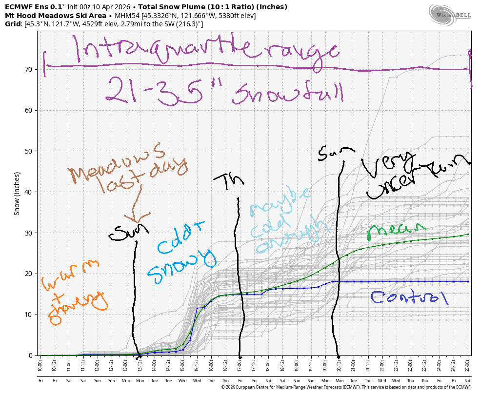
Hey skiers and snowboarders! Now that the season at Meadows is wrapping up, snow is going to reenter the picture next week. It won’t be enough snow to make a huge difference, but we’re likely to see at least a foot. Those of you with Timberline passes might just have some powder days in your future! Intraquartile range for snow for the next couple of weeks is 21-35”, and much of next week has the potential to be cold enough for snow and cloudy enough for long-lasting groomers evne with the strong April sun.
Short term Mt Hood snow forecast
Friday won’t be snowy. It’s too warm. The snow level will be 9000′ in the morning, 8000′ in the afternoon, and 6500′ overnight. Instability this afternoon could fire off some thunderstorms, and we’re expecting some rain overnight. Models give us anywhere from 0.1” to 0.5” rain tonight – they do not handle instability-driven precipitation amounts well. Wind today will be light and variable except during any thunderstorms – if those happen, strong, gusty wind is possible.
Saturday starts with rain or mixed precipitation, turns clear midday, and adds a chance of thundershowers in he afternoon with some rain possible overnight. Precip totals are really impossible to predict in this setup, but they won’t be massive. The snow level will be 6000′ early, 7000′ in the afternoon, and 6000′ overnight. Given the lapse rates, we could see wet snow (not sticking snow) down to lower elevations. Wind will be W 20 in the morning, SW 10-15 in the afternoon, and light/variable overnight.
Extended Mt Hood Snow Forecast
Sunday brings a few mixed precip showers before partly cloudy sky returns in the afternoon. The snow level will be 6000′ in the morning, 6500′ in the afternoon, and 3000′ after midnight. Temps max out in the upper 30s. Wind will be variable to 5mph in the morning, WNW 20-30 in the afternoon, and W 30 overnight.
Monday looks clear and cooler with max temps in the low to mid 30s. Tuesday will be cool and high overcast. Snow returns Tuesday sometime (probably late) and continues into Wednesday. Up to a foot is possible! That’s followed by a few days of cool weather and the potential for a little more snow. Uncertainty climbs Thursday and continues into the deeper future. The potential for a foot or more of snow is exciting – we’ll take anything we can get to support the summer snowpack. See you on the snow soon!
Was that helpful? I knew it was! Guess what? All of this crucial work – from your personal wind and snow reports to the invaluable TATAS updates – is made possible by my relentless efforts. Maintaining this labor of love isn’t easy. Each daily forecast takes hours. Website hosting, weather model access, and back-end admin work takes time and money. That’s where you come in.
YOUR CONTRIBUTION MAKES A DIFFERENCE
- SUPPORT ACCURATE, HYPER-LOCAL WEATHER FORECASTING
- ENABLE ACCESS FOR ALL, EVEN THOSE WITH LESS MEANS
- SUPPORT A COOL HUMAN WHO WORKS HARD SO YOU CAN PLAY
Take a moment to click one of the buttons below. Donate $19.99 or more (how much does this forecast enhance your life?) and get the email in your inbox. Whether it’s a renewing subscription (auto-renew) or a one-time donation, every contribution makes a real difference. Help me keep this labor of love alive, so we can all continue playing, commuting, and living in the Gorge with peace of mind and the best weather forecasts possible. Thank you!


Hood River, Oregon 97031


GORGE WIND FORECAST
If you’re still seeing yesterday’s and it’s after 9am, try opening this in an incognito window
SHORT-TERM gorge wind forecast
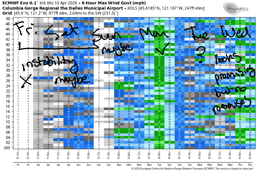
Hi friends! Active weather over the next several days gives us some potential for westerlies, but lingering instability will impact wind quality and reliability. Best setup for westerlies looks to be Sunday or Monday. Generally speaking, the overall setup suggests west wind into next week.
Friday, however, started with easterlies, and it’ll stay that way. Peak wind will be mid-morning at Stevenson where you’ll find gusty 15-20mph for a few hours. By afternoon, the wind in the usual spots drops to 10mph or less. Thanks to an offshore low, easterlies pick up to 15mph east of The Dalles for a few hours this afternoon. River flow over the last 24 hours was 141-208kcfs, river temp is 48.9F, and high temp forecast is 68F under cloudy sky with a chance of showers and thundershowers.
RIVER FLOW FOR SITES BETWEEN AVERY (EAST OF THE DALLES) AND RUFUS: CLICK HERE FOR JOHN DAY DAM FLOW.
RIVER FLOW FOR SITES BETWEEN STEVENSON AND DOUG’S BEACH (WEST OF THE DALLES): CLICK HERE FOR THE DALLES DAM FLOW

LONGER-TERM gorge wind forecast
West wind is in the cards on Saturday, but widespread surface instability will decrease quality and reliability. The day starts with 5-10mph west of The Dalles and 18-21mph from Avery to Arlington. Areas from Lyle to Boardman climb to gusty 20-23mph late morning while the western Gorge stays at 10mph or less. After 2pm, all locations fall to the 10-13mph range or less. The higher wind speeds will only be achieved if instability doesn’t interfere too much. High temp: 65F with intermittent showers, clouds, and a chance of thunderstorms.
Things start to settle down on Sunday as a low pressure system exits east and high pressure builds offshore. We’re left with a decent onshore temp/pressure gradient. After a light start, westerlies build to gusty 15-18mph from Stevenson to Hood River with 25-28mph from Mosier to Rufus. After 5pm, as the west side stabilizes thanks to marine influence, westerlies climb even more. Cross your fingers this timing holds – we keep getting after-dark westerlies, and that could be the case again Sunday. High temp: 63F and mostly cloudy with scattered sprinkles.
On Monday, cool air penetrates far into the Gorge. The desert retains at least some heat. For now, models have us with gusty teens west of Lyle and 26-29mph from Lyle to Threemile. Given that Monday is still several days away, this forecast could change some. A weather system approaches on Tuesday from the northwest and triggers another round of gusty westerlies. Details are unclear on the timing and details of all this, but generally speaking, the weather will be cool and showery for several days with west wind of some sort. Hope to see you on the Nch’i Wana soon!

BARE BONES HOOD RIVER WEATHER FORECAST
Cloudy today with thundershowers possible and rain overnight. Temps start in the upper 40s and rise to the upper 60s. Light easterlies. 84% chance of rainbows. Saturday will be cloudy with rain early then partly cloudy with a chance of thundershowers. Temps star tint he upper 40s and rise to the mid 60s. Light westerlies. 97% chance of rainbows. Sunday will be mostly cloudy with scattered showers. Temps start in the mid 40s and rise to the low 60s. Light westerlies early. Moderate most of the day. 31% chance of rainbows.
TEMIRA’S AWESOME TRAVEL ADVISORY SERVICE
HYPERLOCAL WEATHER FORECAST FOR THE COLUMBIA GORGE
THE DALLES, HOOD RIVER, WHITE SALMON, TROUT LAKE, STEVENSON, CASCADE LOCKS, PARKDALE, ODELL, HUSUM, BZ, MILL A, WILLARD, GOLDENDALE, RUFUS, ARLINGTON, boardman
Good morning, neighbors! So much for sunshine… a couple days of unstable, warm weather (NOT A STABLE GENIUS!) precede cooler weather next week. With so many clouds around this weekend, frost is not in the picture. Maybe next week when even cooler temps combine with periods of clear sky. I’m a bit nervous about that! Biggest excitement other than the instability? Actual rain with actual mountain snow for the middle part of next week!
Glenwood this morning & Today’s Gorge weather forecast
Looking around the Gorge this morning, we’re mostly in the upper 40s. Glenwood, the family overachiever, was 38F this morning. Today’s highs rise to the upper 60s. If clouds break up mid-afternoon (vote for this!), instability will get triggered and we might see some thunderstorms. If nothing else, we’re likely to see some rain overnight as far east as Biggs and into South Wasco County. Rain + blossoms is not a good combo. Blossoms + you on a bicycle in Odell is a good combo – SO PRETTY RIGHT NOW! Go check it out and make your heart happy. Today’s wind will be somewhere between calm (right now) and E 15mph (Stevenson midday, east of The Dalles this afternoon) with light easterlies in the hills.
Saturday’s Gorge weather forecast
Overnight, thanks to cloud cover, temps barely fall into the 40s in the lowlands. Elevated areas: upper 30s to low 40s on Saturday morning. Showers linger as far east as The Dalles until late morning. Temps eventually rise to the mid 60s (west side, Hood River, The Dalles) and low 70s (out in the desert). This temp gradient leads to west wind at 20-25mph from Lyle to Boardman (10mph to the west) after a light wind start. Afternoon heating leads to another round of possible thundershowers.
Sunday’s Gorge weather forecast
More stable air arrives Sunday. We’ll still be mostly cloudy most of the day. Morning temps start in the mid 40s. Afternoon: 63-64F west of The Dalles and 69F (you know what to do!) out in the desert. Light wind early gives way to 15-20mph west of Mosier and 25-30mph from Mosier to Rufus with less wind to the east.
Extended Gorge weather forecast
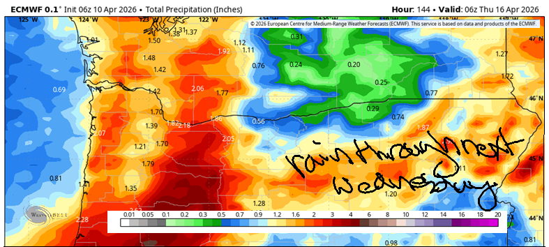
Monday looks cloudy to the west and sunny to the east with highs in the upper 50s and moderately strong west wind. Tuesday: cloudy and a couple degrees cooler with actual rain arriving overnight into Wednesday. On Wednesday, the snow level falls to 3000′. Expect snow on the mountain passes. Cool weather lingers into the end of next week, and then uncertainty rises. No hot weather or lowland snow is forecast. In an interesting historical note, the latest significant snowfall is 4/11/2022 when about 8” snow fell across the Gorge and on all the blooming orchards. Not gonna happen this year, thankfully. Safe travels. -TATAS
HEY! DON’T STOP READING! Is this community-focused forecast helpful to you? It sure is! It takes me a couple hours a day to write. Please join your friends and neighbors in contributing to keep it going. Venmo: @thegorgeismygym PayPal: twomirrors@gmail.com USPS: Temira / PO Box 841 / Hood River, Oregon 97031 You can test out the forecast subscription for a few days for free by signing up below. Easy! Do it!
JONES BEACH, SAUVIE ISLAND, & COAST FORECAST
ON WINTER VACATION UNLESS DESPERATELY NEEDED.

Leave a Reply