

MT HOOD SNOW FORECAST

Hey skiers and snowboarders! Big hope in the forecast once again…. Not much happens (other than a lot of wind) through Monday morning, but then our fortunes may shift. Colder air drops down from Canada and encounters straight westerly flow coming in from the Pacific. At various times next week, W or NW flow has the potential to encounter moderate amounts of atmospheric moisture. Combine the direction of the flow, the temps, and the moisture for significant orographically-enhanced snowfall potential on Mt. Hood.
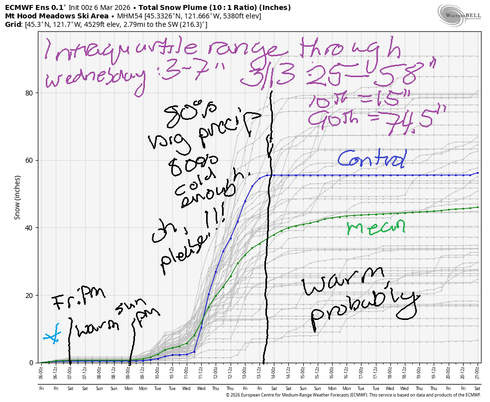
Uncertainty remains high after Tuesday as we wait to see exactly how far south the cold air progresses. As long is it’s far enough south, we’ve got a chance for goodness! The intraquartile range through the end of that pattern, approximately 3/13, is 25-58”. The intensity of the uncertainty is visible in the 10th-90th percentile range: 15”-75” for that same time period!
Last thing before we dive into the deets – tomorrow (Saturday) is Ski ALS at Meadows. One of my dear friends was recently diagnosed with ALS. If you feel moved, please make a contribution and help me with my fundraising efforts for ALS Northwest. If you do it now, before you read the forecast, you won’t forget!
Looking at Friday, we have warming in the forecast along with the possibility for some light mixed precip. The snow level starts around 3500′, rises to 6000′ in the afternoon and 11,000′ overnight. During the day, we’re expecting 0.1” to 0.2” water equivalent (WE) for an inch or so of wet snow. Snow transitions to drizzle in the afternoon, but only a trace is expected overnight. Wind will be WNW 20 in the morning, NW 25 in the afternoon, and NW 30-35 overnight. That’s probably enough to take out the highest lifts, but the rest should run. Different story on Saturday….
I’m most familiar with the wind impacts at Meadows, and there will likely be impacts on Saturday. First… the snow level will be 11,000′ in the morning, 12,000′ in the afternoon, and 10,000′ overnight. High clouds in the morning give way to clear sky in the afternoon. A bit of orographic drizzle is possible in the morning, but it won’t be a measurable amount. Wind… right now, the forecast calls for NW 35 in the morning, NW 30 in the afternoon, and W 35 overnight. That wind strength and direction will affect lift ops. At Meadows, the six-pack Mt. Hood Express can sometimes handle this much wind. So… fingers crossed!
Sunday brings sun up high and clouds below about 6000′. The snow level will be 10,000′ in the morning, 6000′ in the afternoon, and it’ll crash to 1000′ or so overnight. Up to 0.1” WE drizzle is forecast during the day thanks to orographic assistance. Chances are good we’ll see less precip than that at the base and none at all if you can get above the clouds. Good luck with that – the wind will take out the high lifts, but the regular slate of lifts should run despite a stiff breeze: W 35 early, W 35-40 for the rest of the daylight hours, and NW 20-25 overnight.
Monday looks colder with high clouds in the morning and a few flurries overnight. The snow level will be under 1500′ all day long. Up to an inch of snow is forecast overnight. Wind: NW 25-30 in the morning, W 25-30 in the afternoon, and W 20 overnight.
Light snow is forecast on Tuesday along with cold temps. The forecast gets a LOT more interesting starting Wednesday when uncertainty also increases. Most (about 80%) of the ensembles members like the idea of cold air, W or NW flow, and decent moisture. Go ahead and vote for ALL the moisture combined with the cold air dropping plenty far south to convert that moisture to snow. Not only do we have a shot a big snowfall, we also have a shot at shutdown winds. Well, fine, be that way, Ma Nature. We’ll take the snow even if we have to wait a day to shred it. Fingers crossed, everyone! See you on the snow soon!
Was that helpful? I knew it was! Guess what? All of this crucial work – from your personal wind and snow reports to the invaluable TATAS updates – is made possible by my relentless efforts. Maintaining this labor of love isn’t easy. Each daily forecast takes hours. Website hosting, weather model access, and back-end admin work takes time and money. That’s where you come in.
YOUR CONTRIBUTION MAKES A DIFFERENCE
- SUPPORT ACCURATE, HYPER-LOCAL WEATHER FORECASTING
- ENABLE ACCESS FOR ALL, EVEN THOSE WITH LESS MEANS
- SUPPORT A COOL HUMAN WHO WORKS HARD SO YOU CAN PLAY
Take a moment to click one of the buttons below. Donate $19.99 or more (how much does this forecast enhance your life?) and get the email in your inbox. Whether it’s a renewing subscription (auto-renew) or a one-time donation, every contribution makes a real difference. Help me keep this labor of love alive, so we can all continue playing, commuting, and living in the Gorge with peace of mind and the best weather forecasts possible. Thank you!


Hood River, Oregon 97031


GORGE WIND FORECAST
If you’re still seeing yesterday’s and it’s after 9am, try opening this in an incognito window
SHORT-TERM gorge wind forecast
Hi friends! It was fun seeing y’all and getting some rides with you yesterday! More opportunities are coming over the next 7 to 10 days to get yourself some westerlies. Looks like easterlies are out of the picture for a while, in case you wanted that question answered!
Friday started with pressures of 30.41/30.34/30.30 for gradients of 0.07/0.04. Models aren’t all that optimistic about today. They give us 11-14mph from Stevenson to the Hatch mid-morning with 17-20mph east of The Dalles by midday. Afternoon brings 19-22mph east of Rufus with lees than 10mph west of Rufus. Models bring some rain to the eastern Gorge, east of The Dalles, through 1pm. That won’t help the cause. River flow over the last 24 hours was 144-203kcfs (148-203kcfs at Rufus), river temp is 42.6F, and high temp forecast is 52F with lots of clouds.
RIVER FLOW FOR SITES BETWEEN AVERY (EAST OF THE DALLES) AND RUFUS: CLICK HERE FOR JOHN DAY DAM FLOW.
RIVER FLOW FOR SITES BETWEEN STEVENSON AND DOUG’S BEACH (WEST OF THE DALLES): CLICK HERE FOR THE DALLES DAM FLOW

LONGER-TERM gorge wind forecast
Strong offshore high pressure Saturday combines with an onshore temp gradient (mid 50s to the west and mid 60s to the east) and low clouds on the west side for a solid west wind day. Right off the bat, we’ll have 19-22mph from Viento to the Hatch, 13-16mph from Hood River to Doug’s, and 21-24mph from Rufus to Threemile. Midday sees Stevenson-Mosier rise to 25-28mph (if the clouds persist at the Hatch, it’ll be less and also super-gusty), 18-21mph from Lyle to Doug’s, and 24-27mph from Avery to Arlington. Areas east of The Dalles hold into the evening. Models suggest that areas west of The Dalles will drop to 19-22mph in the afternoon. High temps were discussed above, and the sky will have low clouds to the west and clear sky to the east. Enjoy!
On Sunday, we’ll continue with low 20s at the Hatch and potentially mid-20s out east. High temp will be 55F to the west and 64F way out in the desert, which adds thermals support to the offshore high. Monday brings more uncertainty to the picture, but it also has the potential to be windy-enough. Westerlies (probably) back off on Tuesday. Let’s keep a close eye on the second half of next week – there’s some potential for stronger westerlies to return. Fingers crossed! See you on the Nch’i Wana!

BARE BONES HOOD RIVER WEATHER FORECAST
Mostly cloudy sky today with a few sprinkles possible. Temps start in the mid 40s and rise to the low 50s. Light westerlies early and later with moderate westerlies in the middle. 15% chance of rainbows. Saturday will be cloudy early and possibly partly cloudy later. Temps start in the mid 40s and rise to the upper 50s. Moderate westerlies early. Strong westerlies later. 1% chance of rainbows. Sunday will be cloudy. Temps start in the upper 40s and rise to the mid 50s. Moderate to moderately strong westerlies. 1% chance of rainbows.
TEMIRA’S AWESOME TRAVEL ADVISORY SERVICE
HYPERLOCAL WEATHER FORECAST FOR THE COLUMBIA GORGE
THE DALLES, HOOD RIVER, WHITE SALMON, TROUT LAKE, STEVENSON, CASCADE LOCKS, PARKDALE, ODELL, HUSUM, BZ, MILL A, WILLARD, GOLDENDALE, RUFUS, ARLINGTON, boardman
Good morning, neighbors! We’re 48 hours out from an extra hour of daylight in the evening. Hooray! We made it through the Darkness! In an ironic twist, the weather turns colder starting Monday, and there’s even low potential for lowland snow over the next ten days. Uncertainty remains high, so we’ll start with something more certain…
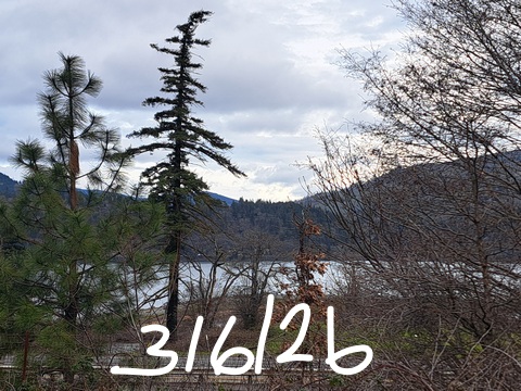
Glenwood this morning
Glenwood started at 38 degrees today, where people are certainly bemused by the ridiculous warmth there this winter. Glenwood is supposed to be frigid. The year, it’s been barely cold enough to qualify as a refrigerator overnight. Maybe this is why we haven’t see !CE for a while – it’s just too warm for them! Haven’t seen them this morning either, despite people looking.
Today’s Gorge weather forecast
Elsewhere in the Gorge today, we’re starting in the mid 40s. We’ll make it to the low 50s (west), mid 50s (The Dalles) and upper 50s (The Desert) this afternoon. Drizzle is possible west of Hood River and east of The Dalles (more sprinkles than steady rain) until late morning or early afternoon. Wind rises to 10-15mph west of The Dalles and 15-25mph east of Rufus.
Saturday’s Gorge weather forecast
Wind is our weather highlight on Saturday along with very warm temps out in The Desert. The day starts with mid-40s in the lowlands along with clouds sky and west wind at 15-25mph all the way from Stevenson (windiest place in the Gorge) to Arlington’s Triangle (most triangular place in the Gorge). Westerlies pick up to 25-35mph from Stevenson to Threemile Canyon (most 3 place in the Gorge) midday. Temps will be impressive: upper 50s (west) to mid 60s (The Desert). After a mostly cloudy start, we finish with sunshine east of Hood River and low clouds to the west. In Wind Johnny world, this is known as a “Classic Gorge Setup” and will result in an orgasmic day for both Boardheads and tumbleweeds.
Sunday’s Gorge weather forecast
A transition day is in the cards on Sunday. Expect drizzle west of Hood River pretty much all day with a short period of drizzle in south Wasco in the evening. Clouds increase during the day for everyone. Morning temps will be in the upper 40s in the lowlands with the snow level at an unseasonably high 10,000′. Afternoon brings mid50s (west) to 60F (The Dalles) to mid 60s (The Desert – SO WARM). West wind will be 20-25mph west of The Dalles and 20-30mph to the east.
Extended Gorge weather forecast
A cold front swings through Sunday night and leaves us, duh, colder on Monday morning. The snow level may fall as low as 1000′. Nothing more than flurries is forecast. Icy roads are possible, but it’s also possible that road temps are too warm to support the formation of ice. Hard to say. Cooler weather is forecast on Tuesday, but moisture is unlikely.
Things get more interesting on Wednesday for a couple reasons: 1) uncertainty is super-duper high, so I can’t actually tell you what will happen; and 2) one of the possible outcomes is snow for folks west of, well, west of somewhere – this particular setup leads to significant rain shadowing.
Looking deeper into the forecast, we have very high uncertainty. Everything depends on how far south the Canadians send their cold air. It’s very kind of them to to share it – after all we’ve done to warm the planet, we would be hard-pressed to make a case for cold air sharing. But Canadians are modeling the goodness of generosity. Hopefully we can model generosity and working towards the common good by implementing common-sense climate protection strategies before we tip over the tipping points. We’re all in this together! Safe travels. -TATAS
HEY! DON’T STOP READING! Is this community-focused forecast helpful to you? It sure is! It takes me a couple hours a day to write. Please join your friends and neighbors in contributing to keep it going. Venmo: @thegorgeismygym PayPal: twomirrors@gmail.com USPS: Temira / PO Box 841 / Hood River, Oregon 97031 You can test out the forecast subscription for a few days for free by signing up below. Easy! Do it!
BARE BONES HOOD RIVER WEATHER FORECAST
Clouds today with rain from mid-morning on. Temps start in the low 40s and rise to the low 50s. Calm wind. 11% chance of rainbows. Thursday will be showery all day. Temps start in the upper 30s and rise to the upper 40s. Moderate westerlies. 99.99% chance of rainbows. Friday will be High overcast and dry in the morning with rain in the afternoon. Temps start in the low-mid 30s and rise to the mid 40s. Light easterlies. 4% chance of rainbows.

Leave a Reply