

MT HOOD SNOW FORECAST

Hey skiers and snowboarders! Apologies for the lack of forecast yesterday – I had a community emergency I was dealing with. I’m setting that aside this morning to get a forecast out. Yesterday’s system provided snow, torrential rain, and a little more snow. It also caused landslides: Highway 35 is closed between MP 76 and 73 (the few miles around Cooper Spur Road) due to landslides. It’s also closed at the 26/35 intersection for the same reason. Why? 5.51” precip yesterday on Mt Hood. Wow. Prior to all that rain melting the snow, there was perhaps half a foot on the ground. Only 2-4” has fallen at the tail end of this system, a lot less than I was expecting.
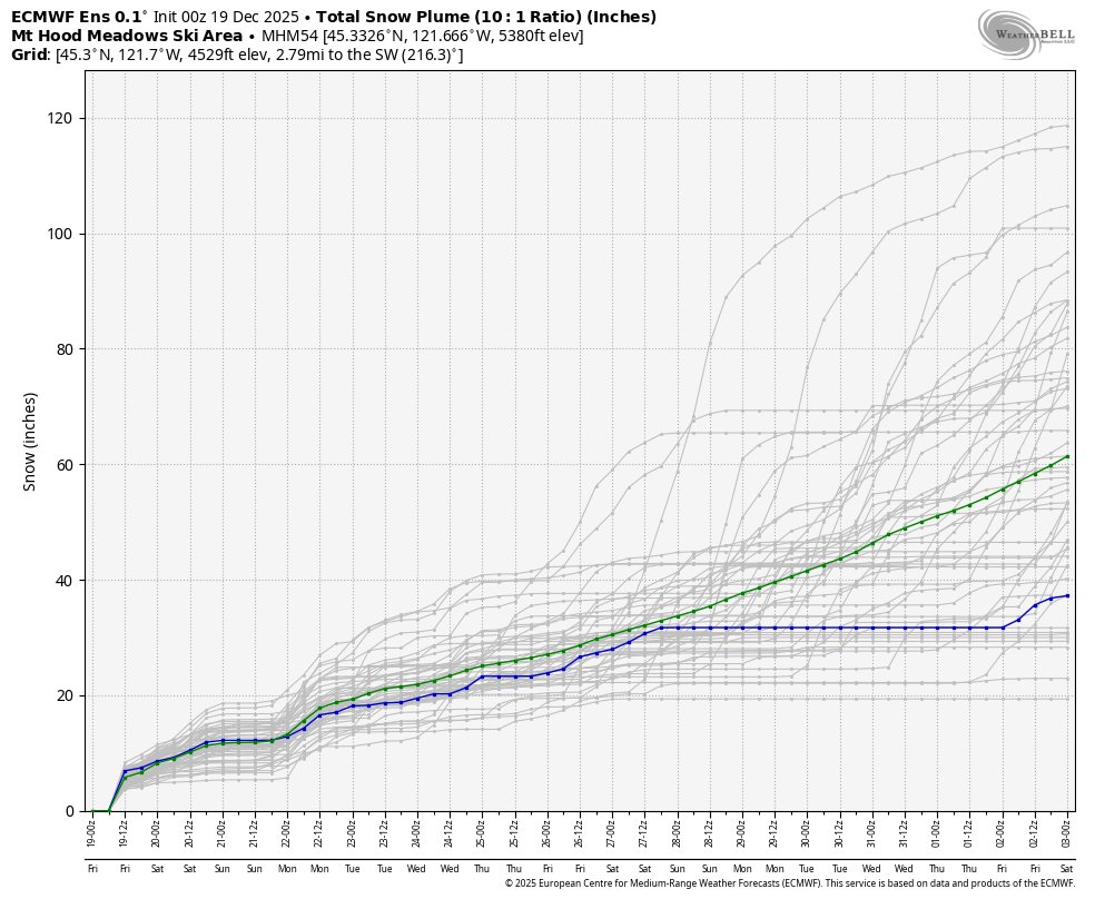
Coming up over the next four to five days, we have perhaps 12-18” total snowfall coming. Is that going to be enough? Meadows says they’ve moved into startup mode – no more hiking/uphill traffic. So… maybe? Teacup has made it happen with 8-12” snowfall, so fingers crossed there, although the warm/wet ground is going to make things tricky. Let’s look at the forecast, shall we?
Short term Mt Hood snow forecast
Light snowfall continues on Friday. The snow level will be around 1500′ all day. A couple inches of snow are forecast this morning. A brief break in the afternoon gives way to a couple more inches of snow. Overnight: another couple inches. Total for the 24 hour period: 4-6”. Wind will be WNW 20-30 early and will turn to SW 15-30 in the afternoon. It holds overnight.
Saturday looks partly cloudy in the morning with clouds and a few flurries in the afternoon. The snow level will be 1500′ early then 2000′ from mid-afternoon on. Wind: SW 15-30 in the morning, SW 10-20 overnight.
Extended Mt Hood Snow Forecast
Sunday starts clear but quickly turns cloudy. The snow level will be 2000′ in the morning, 3500′ midday, and 1500-2000′ overnight. A trace of snow falls during the day. Heavier precip is forecast overnight, perhaps 0.6” WE. That falls as relatively dense snow as temps at 5000′ warm to 30-31F. Call it 4-5” of base-building quality snow. Wind: SW 10-20 in the morning, SW 30-45 in the afternoon, and SW 20-30 overnight.
Monday daytime looks dry. Heavier snow is forecast overnight. Beyond Monday, we’re looking at periods of light snowfall; temps generally look to stay at 32F/0C around 5000′ for a while. That said, uncertainty rises on Tuesday. One thing not seen in the ensembles for the next couple of weeks: Pineapple Express / atmospheric river style rain. Whew. Hope to see you on the snow soon!
Was that helpful? I knew it was! Guess what? All of this crucial work – from your personal wind and snow reports to the invaluable TATAS updates – is made possible by my relentless efforts. Maintaining this labor of love isn’t easy. Each daily forecast takes hours. Website hosting, weather model access, and back-end admin work takes time and money. That’s where you come in.
YOUR CONTRIBUTION MAKES A DIFFERENCE
- SUPPORT ACCURATE, HYPER-LOCAL WEATHER FORECASTING
- ENABLE ACCESS FOR ALL, EVEN THOSE WITH LESS MEANS
- SUPPORT A COOL HUMAN WHO WORKS HARD SO YOU CAN PLAY
Take a moment to click one of the buttons below. Donate $19.99 or more (how much does this forecast enhance your life?) and get the email in your inbox. Whether it’s a renewing subscription (auto-renew) or a one-time donation, every contribution makes a real difference. Help me keep this labor of love alive, so we can all continue playing, commuting, and living in the Gorge with peace of mind and the best weather forecasts possible. Thank you!


Hood River, Oregon 97031


GORGE WIND FORECAST
If you’re still seeing yesterday’s and it’s after 9am, try opening this in an incognito window
today’s gorge wind forecast
Hi friends! It’s very early in the morning on Friday. Apologies for the no-forecast yesterday. I was almost through writing it when a community emergency pulled me away. Anyway… not much happens in wind world the next few days. It’s probably worth checking out the smaller rivers this morning, tho – they’re raging!
Early this morning, big eastern-Gorge gradients were driving wind in the mid to upper 20s, but that will fade quickly. We’re left with 10mph or so west of The Dalles and 18-22mph from Avery to Hermiston. River lover over the last 24 hours was 199-246kcfs (wow, high for winter!), river temp is 49.1F (that’s WARM for winter), and high temp forecast is 44F with increasing drizzle after a morning break.
RIVER FLOW FOR SITES BETWEEN AVERY (EAST OF THE DALLES) AND RUFUS: CLICK HERE FOR JOHN DAY DAM FLOW.
RIVER FLOW FOR SITES BETWEEN STEVENSON AND DOUG’S BEACH (WEST OF THE DALLES): CLICK HERE FOR THE DALLES DAM FLOW

Gorge wind forecast beyond today
Saturday starts with light westerlies. Wind east of The Dalles picks up to gusty SW 17-20mph mid-morning before the entire Gorge goes calm in the afternoon. High temp: 45F with cloudy sky. Sunday brings light easterlies, then calm wind, then light westerlies west of Viento. High temp: 443F. Not much more is forecast fro Monday and Tuesday: easterlies Monday, and light/variable wind Tuesday. I’m not sure which sport to substitute right now with everything drenched… maybe trail running?
extended Gorge wind forecast
BARE BONES HOOD RIVER WEATHER FORECAST
Drizzle this morning, maybe a break for a little bit, then rainy into the night. Temps start in the low 40s and rise to the mid 40s. Light westerlies. 99% chance of rainbows. Saturday will be dry in the morning, drizzly in the afternoon, and dry overnight. Temps start in the mid 30s and rise to the mid 40s. Light westerlies. 99% chance of rainbows. Sunday will be dry early then wet the rest of the day. Temps start in the low-mid 30s and rise to the low 40s. Light easterlies early. Calm wind later. 18% chance of rainbows.
TEMIRA’S AWESOME TRAVEL ADVISORY SERVICE
HYPERLOCAL WEATHER FORECAST FOR THE COLUMBIA GORGE
THE DALLES, HOOD RIVER, WHITE SALMON, TROUT LAKE, STEVENSON, CASCADE LOCKS, PARKDALE, ODELL, HUSUM, BZ, MILL A, WILLARD, GOLDENDALE, RUFUS, ARLINGTON, boardman

Good morning, neighbors! Thanks for understanding the lack of forecast yesterday due to a community emergency. Thankfull, weather-wise, we all knew what was coming. It was very exciting to see the snow part of the forecast verify even lower in elevation than I’d expected. EVAPORATIVE COOLING FOR THE WIN!!! Unfortunately, the snow contributed to slippery roads along with the dangerously ¡CY roads around Hood River. Around the region, we set numerous rain records – definitely in Hood River. Rain totals in the western Gorge were in the 4-5” range. That’s incredible! Contrast that with Meadows, which got 5.51”. Just wow. Take a look at the rivers this morning – they’ll be raging. Fortuantely, the Hood seems to have peaked around 12′ rather than the forecast of 16′. Whew. Coming up in the next five days or so, some snow is possible for 1500′ and above at times.
Checking out today’s start… unfortunately it started around midnight or 1am with ¡CY roads in both Hood River and near Van Horn Drive (2 White, 1 black SUV, white ones lacking plates; black Chevy Impala). Act as if the entire Gorge is ¡CY today. Glenwood was 38 degrees to start this morning. Highway 35: closed between MP 73 and 76 (the S-curves area near Cooper Spur Road) due to a landslide. It’s also closed at the 26/35 intersection for the same reason. As of the time of this forecast (prior to 5am), both SR-14 and I-84 were open. Do be cautious out there – slopes will be unstable from all this rain.
Today’s weather has light rain early west of Mosier, a short break for some, and then increasing rain again into the evening. Rain returns to The Dalles by 1pm and to the Arlington Triangle by 4pm. Out near Arlington, the rain will fall in the shape of triangles! Acros the river in Roosevelt, the rain will fall in the shape of strikers. Combine the two for the sounds of an elementary school holiday concert! Rain intensity: mostly light, but it’ll be heavy 10pm-1am west of Hood River. Temps rise to the mid 40s (west) and upper 40s (east) today. I can’t rule out a few snowflakes mixed in for our higher elevations. Above 1500′, a trace to an inch of snow is likely tonight with the potential for a a little more between Willard and Underwood.
Saturday will be dry in the morning. Rain returns west of Viento mid-morning and continues until sunset. Light rain. Morning temps will be in the mid 30s under cloudy sky to the west and clear sky to the east. This puts areas like Centerville and Goldendale and elevated ares of The Dalles and Mosier at risk for icy roads. Afternoon temps rise to the mid 40s. Wind will be under 10mph west of The Dalles with 15-20mph out of the west to the east of The Dalles.
Thanks to clear sky for part of Sunday night, we’re likely to see temps dip near or below freezing in many areas. As of right now, precip is forecast to return mid-morning. That’s just early enough we could see a few snowflakes for those of you up high and west of Hood River. Rain eventually spreads as far east as Hermiston. For the gauntlet (Troutdale to Viento), we’ll have heavy rain (but not torrential) from around 4pm to around 10pm. High temps: low 40s.
Monday daytime looks non-impactful – maybe a few showers. Moderate rain returns overnight with the snow level around 2500′. Non-impactful, intermittently rainy weather continues into next week. Uncertainty increases on Tuesday. One impact to note: starting right now, you can expect snow on the mountain passes for the foreseeable future. Take care out there. Safe travels. -TATAS
HEY! DON’T STOP READING! Is this community-focused forecast helpful to you? It sure is! It takes me a couple hours a day to write. Please join your friends and neighbors in contributing to keep it going. Venmo: @thegorgeismygym PayPal: twomirrors@gmail.com USPS: Temira / PO Box 841 / Hood River, Oregon 97031 You can test out the forecast subscription for a few days for free by signing up below. Easy! Do it!
JONES BEACH, SAUVIE ISLAND, & COAST FORECAST
ON WINTER VACATION UNLESS DESPERATELY NEEDED.
